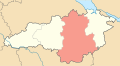
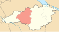
Oblast (region) of Ukraine
Oblast in Ukraine
Kirovohrad Oblast
(
Ukrainian
:
К?ровоградська область
,
romanized
:
Kirovohradska oblast
), also known as
Kirovohradshchyna
(
Ukrainian
:
К?ровоградщина
), is an
oblast
(region) in central
Ukraine
. The
administrative center
of the oblast is the city of
Kropyvnytskyi
. Its population is
903,712 (2022 estimate).
[2]
It is Ukraine's second least populated oblast, behind
Chernivtsi
.
In 2019, the
Constitutional Court of Ukraine
approved the change of the oblast's name to
Kropyvnytskyi Oblast
(
Ukrainian
:
Кропивницька область
,
romanized
:
Kropyvnytska oblast
, unofficially
Kropyvnychchyna
(
Ukrainian
:
Кропивниччина
)).
[4]
The change is not yet implemented. The largest cities of the region are
Kropyvnytskyi
,
Oleksandriia
,
Znamianka
and
Svitlovodsk
.
Geography
[
edit
]
The area of the province is 24,600 square kilometres (9,500 sq mi).
The city of
Dobrovelychkivka
is the geographical center of Ukraine.
Most of the region is located within historic
Right-bank Ukraine
and
Zaporizhzhia
, and the western outskirts are part of historic
Podolia
.
History
[
edit
]
The lands of the modern Kirovohrad Oblast were first inhabited by
Scythians
.
[5]
[6]
In the Middle Ages, during the time of
Kyivan Rus'
, the East Slavic tribe of Ulichis lived here.
[7]
After the liberation of the former Kyivan Rus' from the Tatars in the
Battle of Blue Waters
and the unification of the principalities of Kyiv, Pereyaslav, and Chernihiv with the
Grand Duchy of Lithuania
,
[8]
[9]
there was a need to protect the southeastern borders from attacks by the
Crimean Khanate
and
Moscovy
- states that were formed after the collapse of the
Golden Horde
at the end of the 15th century. For this,
Dmytro Vyshnevetsky
founded the first
Zaporozhian Sich
on the island of
Khortytsia
, thus the Ukrainian Cossacs appeared.
[10]
On the territory of the modern Kirovohrad region the Zaporozhians founded many villages. From 1569, the territory formed of the
Kingdom of Poland
within the
Polish?Lithuanian Commonwealth
.
These lands were under the rule of the Ukrainian Cossacks of
Hetmanate
and
Zaporozhian Sich
from XV to XVIII century.
[11]
 One of the unique granite columns with which the Cossacks marked their territory
As a result of the
destruction of Ukrainian Cossacks
and the
enslavement
of Ukrainians by the Russian government at the end of the 18th century, these lands came under the direct power of Russia.
[12]
[13]
In 1752, the territory of
New Serbia
was founded with the capital in
Novomyrhorod
.
In the 1800s, majority of the landed was owned by the noble
Skar?y?ski
family.
[14]
They played a large role in the development of the region. An emphasis was placed on the development of its agriculture and the Skarzynskis opened a school in
Migeya
dedicated to this.
[15]
The oblast was created as part of the
Ukrainian SSR
on January 10, 1939 out of the northern raions of
Mykolaiv Oblast
. Before establishment, its territory was part of
Kherson Governorate
(most of it) and
Podolia Governorate
(smaller portion) until 1925. Earlier before occupation of Ukraine in 1920s, in 1918 there were plans to introduce own Ukrainian administrative territorial division with territory of modern Kirovohrad Oblast being split between lands of Nyz (Lower land), Pobozhia (Boh land), and Cherkasy.
During the
Soviet repressions
, over 40,000 residents of the region were killed.
[16]
[17]
[18]
[19]
In 1954, the oblast lost some raions to the newly created
Cherkasy Oblast
, but later that year received its western raions from the
Odesa Oblast
.
Between 1939 and 2016, the oblast administrative center, Kropyvnytskyi, was called Kirovohrad and was named after the First Secretary of the
Leningrad City Committee
of the
All-Union Communist Party (Bolsheviks)
Sergei Kirov
.
[20]
Due to
decommunization laws
(on 14 July 2016) the name of the city was changed to Kropyvnytskyi.
[20]
Kirovohrad Oblast was not renamed because as such it is mentioned in the
Constitution of Ukraine
, and the Oblast can only be renamed by a
constitutional amendment
by the
Verkhovna Rada
.
[21]
On 20 June 2018, the Committee on State Building, Regional Policy and Local Self-Government of the
Ukrainian parliament
backed the proposal to rename Kirovohrad Oblast to
Kropyvnytskyi Oblast
.
[22]
In February 2019, the
Constitutional Court of Ukraine
declared constitutional the bill on renaming Kirovohrad Oblast to Kropyvnytskyi Oblast.
[23]
[24]
The renaming was supported by the local Oblast Council in March 2021.
[25]
[26]
The process then stalled in the parliament, with the oblast council asking the
Verkhovna Rada
to speed up the process in September 2022.
[27]
Points of interest
[
edit
]
The following sites were nominated for the
Seven Wonders of Ukraine
:
The oblast also has a number of archaeological sites, such as
Nebelivka site
and
Melgunov Kurgan
.
Administrative divisions
[
edit
]
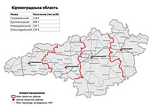 Raions of Kirovohrad Oblast as of August 2020.
| Kirovohrad Oblast
|
| As of January 1, 2022
|
| Number of districts (райони)
|
4
|
| Number of hromadas (громади)
|
49
|
Raions
| No.
|
Name
|
Coat of arms
|
Population,
(2020).
|
Area,
km²
|
Density,
per km²
|
Administrative
center
|
Map
|
Subdivisions
|
| 1
|
Holovanivsk
|

|
122,952
|
4,244
|
28.97
|
Holovanivsk
|

|
10 hromadas
|
| 2
|
Kropyvnytskyi
|

|
442,997
|
9,709
|
45.62
|
Kropyvnytskyi
|
|
17 hromadas
|
| 3
|
Novoukrainka
|

|
140,539
|
5,196
|
27
|
Novoukrainka
|
|
13 hromadas
|
| 4
|
Oleksandriia
|

|
226,721
|
5,405
|
41.94
|
Oleksandriia
|

|
9 hromadas
|
Before the
July 2020 reform
, Kirovohrad Oblast was administratively subdivided into 21
raions
(
districts
) as well as 4 cities (
municipalities
) which were directly subordinate to the oblast government:
Oleksandriia
,
Svitlovodsk
,
Znamianka
, and the administrative center of the oblast,
Kropyvnytskyi
.
Demographics
[
edit
]
Language
[
edit
]
According to the
2001 Ukrainian census
,
Ukrainian
was the mother tongue of 88.9% of the population, for 10.0% it was
Russian
, and for 1.1% it was another language.
According to a survey "Is the language (ir)relevant?" (
Ukrainian
:
"Мова (не) на час??"
), which took place in Kirovohrad Oblast from 12 to 22 October 2023, 96.7% of respondents named Ukrainian as their mother tongue, while 2.6% named Russian as their mother tongue. In everyday life, 66.4% of respondents spoke Ukrainian, 29.4% spoke
Surzhyk
, and 3.4% spoke Russian.
[28]
Age structure
[
edit
]
- 0-14 years:
14.3%
 (male 72,646/female 68,970)
- 15-64 years:
68.7%
 (male 324,698/female 355,058)
- 65 years and over:
17.0%
 (male 55,718/female 111,666) (2013 official)
Median age
[
edit
]
- total:
41.2 years
- male:
37.7 years
- female:
44.5 years
(2013 official)
Nomenclature
[
edit
]
Most of Ukraine's oblasts are named after their
capital
cities, officially referred to as "oblast centers" (
Ukrainian
:
обласний центр
,
translit.
oblasnyi tsentr
). The name of each oblast is a
relative
adjective
, formed by adding a feminine
suffix
to the name of the respective center city:
Kirovohrad
was the former name of the center of the
Kirovohrads’ka oblast’
(Kirovohrad Oblast). Most oblasts are also sometimes referred to in a feminine noun form, following the convention of traditional regional place names, ending with the suffix "-shchyna", as is the case with the Kirovohrad Oblast,
Kirovohradshchyna
.
Facts
[
edit
]
Gallery
[
edit
]
See also
[
edit
]
References
[
edit
]
- ^
Syvak, Nina; Ponomarenko, Valerii; Khodzinska, Olha; Lakeichuk, Iryna (2011). Veklych, Lesia (ed.).
Toponymic Guidelines for Map and Other Editors for International Use
(PDF)
. scientific consultant Iryna Rudenko; reviewed by Nataliia Kizilowa; translated by Olha Khodzinska. Kyiv: DerzhHeoKadastr and Kartographia. p. 20.
ISBN
978-966-475-839-7
. Retrieved
2020-10-06
.
- ^
a
b
Чисельн?сть наявного населення Укра?ни на 1 с?чня 2022
[
Number of Present Population of Ukraine, as of January 1, 2022
]
(PDF)
(in Ukrainian and English). Kyiv:
State Statistics Service of Ukraine
.
Archived
(PDF)
from the original on 4 July 2022.
- ^
"Валовии рег?ональнии продукт"
.
- ^
"The Opinion of the Constitutional Court of Ukraine in the case of renaming the Kirovohrad oblast is given"
.
Укра?нське право - ?нформац?йно-правовий портал
. 5 February 2019.
- ^
Антрополог?чний склад укра?нського народу: етногенетичний аспект. ? К.: Видавництво ?м. Олени Тел?ги, 2001
- ^
Геродот ≪?стор?я≫ Кн. 4. Абз. 11.
- ^
Повесть временных лет, т. I. М.; Л., 1950. С. 20, 21
- ^
Stryjkowski, Kronika Polska... 1846: 6?7.
- ^
Брайченко Олекс?й. Синьоводська проблема: перспективи комплексних кра?знавчих досл?джень // Синьоводська проблема у нов?тн?х досл?дженнях. ? К., 2005. ? С. 37.
- ^
?дине в?доме на сьогодн? писемне джерело, котре ясно вказу? на м?сце буд?вництва замку (хрон?ка Йоахима та Мартина Б?льських), назива? остр?в Малу Хортицю
- ^
Громко Т. В. Семантичн? особливост? народно? географ?чно? терм?нолог?? Центрально? Укра?ни (на матер?ал? К?ровоградщини). ? К?ровоград, 2000
- ^
Яворницький Д. ?. ?стор?я запорозьких козак?в. ? К., 1991. ? Т. ?.
- ^
Ключевский В. О. Происхождение крепостного права в России / В. Ключевский. ? СПб., 1885.
- ^
"Скаржинские"
. 21 February 2011.
- ^
"Ольгинская сельскохозяйственная школа /Ольгинско-Скаржинская сельскохозяйственная школа, Ольгинско-Скаржинское сельскохозяйственное училище/"
. 31 October 2012.
- ^
Виконавчий ком?тет Знам'янсько? м?сько? ради, Арх?вний в?дд?л м?сько? ради, В?дд?л внутр?шньо? пол?тики м?ськвиконкому Чорна смуга довжиною в два роки. Книга пам'ят? м?ста Знам'янки та смт. Знам'янка Друга К?ровоградсько? област? ? Знам'янка, 2008
- ^
Олександр Рябошапка Знам'янка: зал?зниця, ?стор?я, люди. ? К?ровоград, Цетрально-Укра?нське видавництво, 1995 (ст. 20 ? 21).
- ^
Олександр?я. Гео?нформац?йна система м?сць ≪Голодомор 1932?1933 рок?в в Укра?н?≫. Укра?нський ?нститут нац?онально? пам'ят?.
- ^
?стор?я м?ста. Новоукра?нська м?ська рада (uk-ua) . Процитовано 17 листопада 2021
- ^
a
b
Goodbye, Lenin: Ukraine moves to ban communist symbols
,
BBC News
(14 April 2015)
(in Ukrainian)
Verkhovna Rada renamed Kirovograd
,
Ukrayinska Pravda
(14 July 2016)
- ^
Ukraine
,
The World Factbook
- ^
Ukraine's parliament committee backs renaming of Dnipropetrovsk, Kirovohrad regions
,
UNIAN
(20 June 2018)
- ^
"Надано Висновок Конституц?йного Суду Укра?ни в справ? щодо перейменування К?ровоградсько? област? | Конституц?йний Суд Укра?ни"
.
www.ccu.gov.ua
. Retrieved
2019-06-13
.
- ^
"Constitutional Court Declares Bill Renaming Kirovohrad Region As Kropyvnytskyi Region Constitutional"
.
ukranews.com
. 2019-02-06
. Retrieved
2019-06-13
.
- ^
"Перейменування К?ровоградсько? област? - звернення до ВРУ"
.
Suspilne
(in Ukrainian). 2021-03-30.
- ^
Купюр, Без (2021-04-22).
"Верховна Рада в?дреагувала на звернення про перейменування К?ровоградщини формально | Без Купюр - Новини Кропивницького ? К?ровоградщини"
.
Без Купюр
(in Ukrainian)
. Retrieved
2023-02-04
.
- ^
"К?ровоградська облрада закликала Верховну Раду пришвидшити перейменування област?"
.
hromadske.ua
(in Ukrainian). 2022-09-21
. Retrieved
2023-02-04
.
- ^
https://suspilne.media/603693-za-cas-vijni-stavlenna-ukrainciv-do-derzavnoi-movi-pomitno-zminilosa-dani-opituvanna-sodo-movi-na-kirovogradsini/
[
bare URL
]
- ^
Укра?н? ? озеро, яке не ма? дна ? н?коли не замерза?
- ^
Пам’ятн? знаки Семену Климовському
External links
[
edit
]
- "Main"
.
Official web-site of the Kirovohrad Oblast State Administration
(in Ukrainian). Archived from
the original
on 13 August 2006
. Retrieved
7 April
2014
.
|
|---|
| International
| |
|---|
| National
| |
|---|
| Geographic
| |
|---|
| Other
| |
|---|