Division of the Habsburg Monarchy
The
Kingdom of Croatia
(
Croatian
:
Kraljevina Hrvatska
;
Latin
:
Regnum Croatiae
;
Hungarian
:
Horvat Kiralysag
,
German
:
Konigreich Kroatien
) was part of the
Lands of the Hungarian Crown
, but was subject to direct Imperial Austrian rule for significant periods of time, including its final years. Its capital was
Zagreb
. It was also a part of the lands of the
Habsburg monarchy
from 1527, following the
Election in Cetin
, and the
Austrian Empire
from 1804 to 1867.
The Kingdom of Croatia had large territorial losses in
wars with the Ottoman Empire
in the 16th century. Until the 18th century, the kingdom included only a small north-western part of present-day
Croatia
around Zagreb, and a small strip of coastland around
Rijeka
, that were not part of the
Ottoman Empire
or part of the
Croatian Military Frontier
. Between 1744 and 1868, the Kingdom of Croatia included a subordinate autonomous kingdom, the
Kingdom of Slavonia
. The territory of the Slavonian kingdom was recovered from the Ottoman Empire, and was subsequently part of the Military Frontier for a short period. In 1744, these territories were organized as the Kingdom of Slavonia and included within the Kingdom of Croatia as an autonomous part. In 1868, they were merged into the newly formed
Kingdom of Croatia-Slavonia
.
History and government
[
edit
]
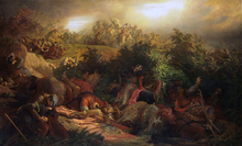 Battle of Mohacs
1526
by
Bertalan Szekely
Battle of Mohacs
1526
by
Bertalan Szekely
Habsburg rule
[
edit
]
Following the fall of the
medieval Kingdom of Hungary
at the
Battle of Mohacs
, in 1527 the
Croatian
and
Hungarian
nobles needed to decide on a new king. The bulk of the Croatian nobility
convened the Croatian Parliament in Cetin
and chose to join the
Habsburg monarchy
under the Austrian king
Ferdinand I
of
Habsburg
.
[3]
[4]
Some nobles dissented and supported
John Zapolya
, but the Habsburg option fully prevailed in 1540, when John Zapolya died.
Territory recovered by the Austrians from the
Ottoman Empire
was formed in 1745 as the
Kingdom of Slavonia
, subordinate to the Croatian Kingdom. In 1804 the
Habsburg monarchy
became the
Austrian Empire
which annexed the
Venetian Republic
in 1814 and established the
Kingdom of Dalmatia
. After the
Austro-Hungarian Compromise of 1867
(by which the Austrian Empire became the
Austro-Hungarian Empire
) and the
Croatian?Hungarian Settlement
(
Nagodba
) of 1868, the Kingdom of Croatia and Kingdom of Slavonia were joined to create the
Kingdom of Croatia-Slavonia
within the
Hungarian part
of the empire, while the Kingdom of Dalmatia remained a
crown land
in the
Austrian part
of the empire.
Croatian-Ottoman Wars
[
edit
]
The change of leadership was far from a solution to the war with the Ottomans, in fact, the
Ottoman Empire
gradually expanded in the 16th century to include most of
Slavonia
,
western Bosnia
and
Lika
. Croatian territory under Habsburg rule was 25 years later reduced to about 20,000 km
2
(7,700 sq mi). In 1558, the parliaments of Croatia and Slavonia were united after many centuries into one. The centre of the Croatian state moved northward from coastal Dalmatia, as these lands were conquered by the Ottomans. The town of Zagreb gained importance, as did nearby
Vara?din
.
[5]
Taking advantage of the growing conflict between King
Sigismund II of Poland
and
Maximilian II, Holy Roman Emperor
,
Suleiman the Magnificent
started his sixth raid of Hungary in 1565 with 100,000 troops. They successfully progressed northwards until 1566 when they took a small detour to capture the outpost of Siget (
Szigetvar
) which they failed to capture ten years previously. The small fort was defended by Count
Nikola IV Zrinski
and 2,300?3,000 men. They were able to hold their ground for a month, and decimated the Ottoman army before being wiped out themselves. This siege, now known as the
Battle of Szigetvar
, bought enough time to allow Austrian troops to regroup before the Ottomans could reach
Vienna
.
[6]
[5]
 Nikola ?ubi? Zrinski
by
Oton Ivekovi?
. The work depicts Croatian Ban
Nikola IV Zrinski
defending against the Ottomans at the
Battle of Szigetvar
Nikola ?ubi? Zrinski
by
Oton Ivekovi?
. The work depicts Croatian Ban
Nikola IV Zrinski
defending against the Ottomans at the
Battle of Szigetvar
 An old map of Croatia from the end of the 16th century (1593)
 Flag of Croatia from 1848 until it was banned in 1852. It was during that time replaced with the Red-White flag, but was allowed again in 1860.
[1]
[2]
Flag of Croatia from 1848 until it was banned in 1852. It was during that time replaced with the Red-White flag, but was allowed again in 1860.
[1]
[2]
By orders of the king in 1553 and 1578, large areas of Croatia and Slavonia adjacent to the Ottoman Empire were carved out into the
Military Frontier
(
Vojna krajina
or
Vojna granica
) and ruled directly from Vienna's military headquarters. Due to the dangerous proximity to the Ottoman armies, the area became rather deserted, so Austria encouraged the settlement of
Serbs
,
Germans
,
Hungarians
,
Czechs
,
Slovaks
and
Rusyns
/
Ukrainians
and other Slavs in the Military Frontier, creating an ethnic patchwork.
The negative effects of
feudalism
escalated in 1573 when the peasants in northern Croatia and
Slovenia
rebelled against their feudal lords over various injustices such as unreasonable taxation or abuse of women in the
Croatian and Slovenian peasant revolt
.
Matija Gubec
and other leaders of the mutiny raised peasants to arms in over sixty fiefs throughout the country in January 1573, but their uprising was crushed by early February. Matija Gubec and thousands of others were publicly executed shortly thereafter, in a rather brutal manner in order to set an example for others.
After the
Biha? fort finally fell
to the army of the Bosnian
pasha
Hasan Pasha Predojevi?
in 1592, only small parts of Croatia remained unconquered. The remaining 16,800 km
2
(6,500 sq mi) where around 400,000 inhabitants lived were referred to as the "
remnants of remnants of the once great and renowned Kingdom of Croatia
" (
Latin
:
reliquiae reliquiarum olim magni et inclyti regni Croatiae
).
[7]
[8]
The Revived Croatia
[
edit
]
By 1699, the Ottoman Empire was driven out of Ottoman Hungary and Croatia, throughout the course of
Great Turkish War
, and Austria brought the territory back under central control.
 Kingdom of Croatia (including the so-called
Turkish Croatia
(
Turkisch Kroatien
), a green marked territory occupied by the Ottomans) on a 1791 map by Austrian cartographer Franz J.J. von Reilly
Kingdom of Croatia (including the so-called
Turkish Croatia
(
Turkisch Kroatien
), a green marked territory occupied by the Ottomans) on a 1791 map by Austrian cartographer Franz J.J. von Reilly
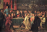 The Croatian Parliament (
Sabor
) in 1848. The tricolour flag can be seen in the background.
The Croatian Parliament (
Sabor
) in 1848. The tricolour flag can be seen in the background.
 The Habsburg Kingdom of Croatia (red) at its largest territorial extent in late 1848. The
Kingdom of Slavonia
(light red) was at the time an autonomous Kingdom subordinate to the Kingdom of Croatia.
The Habsburg Kingdom of Croatia (red) at its largest territorial extent in late 1848. The
Kingdom of Slavonia
(light red) was at the time an autonomous Kingdom subordinate to the Kingdom of Croatia.
 Map of the Kingdom of Croatia (red) in late 1867 and early 1868, before the
Nagodba
. Other lands of the
Austrian Empire
are in light grey.
Map of the Kingdom of Croatia (red) in late 1867 and early 1868, before the
Nagodba
. Other lands of the
Austrian Empire
are in light grey.
The Enlightened Absolutism Period
[
edit
]
Croatia was one of the crown lands that supported Emperor
Charles VI
's
Pragmatic Sanction of 1713
[4]
and supported Empress
Maria Theresa
in the
War of the Austrian Succession
of 1741?48 and the
Croatian Parliament
signed their own
Pragmatic Sanction of 1712
. Subsequently, the empress made significant contributions to Croatian matters, by making several reforms in the administrative control of the Military Frontier, the feudal and tax system. In 1767 she founded the Croatian Royal Council (
Croatian
:
Hrvatsko kraljevinsko vije?e
) as royal government of Croatia and Slavonia, with its seat in Vara?din, later in Zagreb, presided by the
ban
, but it was abolished in 1779 when Croatia was relegated to just one seat in the governing council of Hungary (the Royal Hungarian Council of Lieutenancy, also known as the Hungarian Vice-regency Council, headed by the
palatine
), held by the
ban
of Croatia. The empress also gave the independent port of
Rijeka
to Croatia in 1776. However, she also ignored the Croatian Parliament.
Napoleonic Wars
[
edit
]
With the
fall
of the
Venetian Republic
in 1797, its possessions in the eastern
Adriatic
mostly came under the authority of
France
which passed its rights to Austria the same year. Eight years later they were restored to
France
as the
Illyrian Provinces
, but won back to the
Austrian
crown by 1815.
19th century
[
edit
]
 Field Marshal
count
Josip Jela?i?
,
Ban
of the
Kingdom of Croatia-Slavonia
and Commander of the
Croatian Military Frontier
.
Field Marshal
count
Josip Jela?i?
,
Ban
of the
Kingdom of Croatia-Slavonia
and Commander of the
Croatian Military Frontier
.
In the 19th century Croatian
romantic nationalism
emerged to counteract the non-violent but apparent
Germanization
and
Magyarization
. The Croatian national revival began in the 1830s with the Illyrian movement. The movement attracted a number of influential figures and produced some important advances in the
Croatian language
and culture. The champion of the Illyrian movement was
Ljudevit Gaj
who also reformed and standardized Croatian. The official language in Croatia was Latin until 1847 when it became Croatian.
[4]
By the 1840s, the movement had moved from cultural goals to resisting Hungarian political demands. By the royal order of January 11, 1843, originating from the chancellor
Metternich
, the use of the Illyrian name and insignia in public was forbidden. This deterred the movement's progress but it couldn't stop the changes in the society that had already started.
Springtime of Nations - 1848
In the
revolutions of 1848 in the Austrian Empire
, the Croatian
Ban
Josip Jela?i?
cooperated with the Austrians in suppressing the
Hungarian Revolution of 1848
by leading a military campaign into Hungary, successful until the
Battle of Pakozd
. Despite this contribution, Croatia was later subject to Baron Alexander von
Bach's absolutism
as well as Hungarian hegemony under Ban
Levin Rauch
when the Austrian Empire was transformed into a dual monarchy of
Austria-Hungary
in 1867.
From 1848 to 1850 Croatia was governed by the Ban's Council (
Croatian
:
Bansko vije?e
) appointed by the Ban and the
Parliament
or the
Croatian-Slavonian Diet
(Croatian:
Sabor
; in 1848 first Diet with the elected representatives was summoned). In 1850 the Ban's Council was transformed into Ban's Government (Croatian:
Banska vlada
) which, after the introduction of the
absolutism
(31 December 1851), was under the direct control of the Austrian Imperial Government in Vienna. From 1854 to 1861 the
Imperial-Royal
Croatian-Slavonian Lieutenancy (presided by the ban) in Zagreb (Croatian:
Carsko-kraljevsko namjesni?tvo za Hrvatsku i Slavoniju
), under the Austrian Ministry of Interior, was the main governing body of the Croatian-Slavonian crown land (
Kronland
). After the fall of
Bach's absolutism
(the
October Diploma
of 1860 and the
February Patent
of 1861), the Royal Croatian-Slavonian Court Chancellery (Croatian:
Kraljevska hrvatsko-slavonska dvorska kancelarija
) in Vienna - from 1861 to 1862 "courtly (aulic) department for Croatia and Slavonia" (ministry) - and the Croatian-Slavonian-Dalmatian Royal Council of Lieutenancy (also known as the Croatian-Slavonian-Dalmatian Vice-regency Council, it was headed by the ban; Croatian:
Kraljevsko namjesni?ko vije?e
) in Zagreb were founded. These remained Croatian-Slavonian government until 1868.
[9]
Ban Jela?i? had succeeded in the abolition of
serfdom
in Croatia, which eventually brought about massive changes in society: the power of the major landowners was reduced and arable land became increasingly subdivided, to the extent of risking famine. Many Croatians started emigrating to the
New World
countries in this period, a trend that would continue throughout the next hundred years and create a large Croatian
diaspora
.
The Illyrian movement was rather broad in scope, both
nationalist
and
pan-Slavist
. It would eventually develop into two major causes:
Dual Monarchy Period
[
edit
]
The loss of Croatian domestic autonomy was rectified a year after the
Austro-Hungarian Compromise of 1867
, when in 1868 the
Croatian?Hungarian Settlement
was negotiated, which combined Croatia and Slavonia into the autonomous
Kingdom of Croatia-Slavonia
. With this agreement, the Kingdom of Croatia received autonomy in administrative, educational, religious and judicial affairs.
[10]
However, the
governor (ban)
was still appointed by Hungary, 55% percent of all tax money went to
Budapest
, and Hungary had authority over the biggest sea port of
Rijeka
(something that was reportedly not part of the Settlement actually agreed upon).
Subdivisions
[
edit
]
The Kingdom of Croatia was divided into counties (Croatian:
?upanije
;
German
:
Comitate
(modern spelling
Komitate
) or
Gespanschaften
;
Hungarian
:
varmegyek
;
Latin
(also in other languages):
comitatus
).
Until 1848
[
edit
]
For most of the period of Habsburg rule the Kingdom of Croatia was divided into three counties:
These were direct continuations of the medieval counties of Croatia. (The remainder had fallen to the
Ottomans
, and when conquered by the Habsburgs had become part of either the
Military Frontier
or the
Kingdom of Slavonia
.) In the late 18th century a fourth ?
Severin County
? existed, carved out of the part of Zagreb County west of the
Kupa
, but it lasted for less than a decade before being reintegrated; however, the coastal area was instead attached to the
Corpus separatum
of Fiume (Rijeka) as the
Hungarian or Croatian Littoral
.
The Littoral and most of Zagreb County, although not Zagreb itself or anything north of the Sava, was annexed to the Napoleonic
Illyrian Provinces
in the 1809
Treaty of Schonbrunn
. After the Napoleonic wars in 1815 this territory was returned to Austria but initially formed part of the
Kingdom of Illyria
(as the
Karlstadter
Kreis
and part of the
Fiumaner Kreis
); it was returned to Zagreb County and the Littoral in 1822. As of 1842 the Littoral included (in addition to Fiume) the settlements of
Bakar
(Buccari),
Kraljevica
(Porto-Re) and
Novi Vinodolski
(Novi).
[11]
The counties remained more-or-less unchanged until the
revolutions of 1848
.
From 1848
[
edit
]
In the period following the revolutions of 1848 substantial changes took place in the region. The Slavonian
Syrmia County
de facto
became part of the self-declared
Serbian Vojvodina
in 1848; the eastern half of Syrmia officially became part of the
Voivodeship of Serbia and Banat of Temeschwar
crown land in 1849.
Međimurje
, Fiume and the Littoral became part of Croatia. Croatia and Slavonia were formally a single crown land in 1853.
[12]
The counties were restructured in 1850
[13]
and again in 1854.
[14]
In 1850 the counties were formally referred to in German as
Gespanschaften
and were divided into political districts akin to
those of modern Austria
,
[13]
much like most of the rest of the Empire. In 1854 they were referred to as
Comitate
and a different system of
Bezirke
subordinate to the counties was introduced,
[14]
which mirrored the structure introduced to the re-established
Kreise
in other crown lands. The city of Zagreb/Agram was also made directly subordinate to the kingdom and several other cities were directly subordinate to their counties (rather than a
Bezirk
).
[14]
In 1850 the Slavonian
Virovitica County
became Osijek (Essek) County and it absorbed the rump of Syrmia.
[13]
In 1854 the western exclave of
Po?ega County
(
Kutina
) went to Zagreb (Agram) and western parts of Osijek County (the area around Virovitica) went to Po?ega County.
[14]
In 1850 Vara?din (Varasdin) County absorbed Međimurje (
die Murinsel
), except for the area around
Legrad
, which went to Kri?evci (Kreutz) County.
[13]
Fiume (Rijeka), the Hungarian/Croatian Littoral and western parts of Zagreb (the
Processus
Montanus
) became the new Rijeka (Fiume) County.
[13]
Kri?evci County was dissolved in 1854 and partitioned between Zagreb and Vara?din counties.
[14]
Croatian and Slavonian counties 1850?54:
- Zagreb County (
Agramer Gespanschaft
), comprising the districts (
Bezirke
):
- Rijeka County
(
Fiumer Gespanschaft
), comprising the districts:
- Vara?din County (
Warasdiner Gespanschaft
), comprising the districts:
- Kri?evci County (
Kreutzer Gespanschaft
), comprising the districts:
- Po?ega County (
Po?eganer Gespanschaft
), comprising the districts:
- Osijek County
(
Esseker Gespanschaft
), comprising the districts:
Croatian and Slavonian counties from 1854:
- City of
Agram
(Zagreb)
- Zagreb County (
Comitat Agram
), comprising the districts (
Bezirke
):
- Vara?din County (
Comitat Varasdin
), comprising the districts:
- Rijeka County
(
Comitat Fiume
), comprising the districts:
- Po?ega County (
Comitat Po?ega
), comprising the districts:
- Osijek County
(
Comitat Essek
), comprising the districts:
The Zagreb, Vara?din and Rijeka counties constituted Croatia, while Po?ega and Osijek counties constituted Slavonia.
After 1860
[
edit
]
In 1860 the pre-1848
status quo
was largely restored and the counties reverted to their pre-1848 state. However, Rijeka County was retained until the restructuring of the counties of Croatia-Slavonia in 1886, despite the restoration of the city itself to Hungary.
Demographics
[
edit
]
According to the 1802 data, the population of the Kingdom of Croatia included 400,000 (98.8%)
Roman Catholics
, 4,800 (1.2%)
Eastern Orthodox Christians
and 40
Protestants
.
[15]
In 1840, a Hungarian statistician
Fenyes Elek
analyzed the ethnicity in the countries belonging to the Hungarian Crown. According to the data he collected and processed, 526,550 people lived in the Kingdom of Croatia, out of which 519,426 (98.64%) were
Croats
, 3,000 (0.56%)
Germans
, 2,900 (0.55%)
Serbs
and 1,037 (0.19%)
Jews
.
[16]
[17]
Population data by counties:
Primorje County
Vara?din County
Zagreb County
Kri?evci County
The first modern population census was conducted in 1857 and it recorded religion of the citizens. Population by religion in the counties of Kingdom of Croatia:
[18]
Insignia
[
edit
]
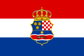
In 1848 the Kingdom of Croatia adopted a new official flag and coat of arms. The new flag was the Croatian tricolor of red, white, and blue, and it was to remain the symbol of Croatia up to the present day. The coat of arms adopted in 1848 was an amalgam of three coats of arms, one for Croatia, another for the
Kingdom of Dalmatia
, and another for the
Kingdom of Slavonia
. The Kingdom also used the name "
Triune Kingdom of Croatia, Slavonia, and Dalmatia
" during certain periods (though this was not recognized by the Empire). The Kingdom still controlled the
Kingdom of Slavonia
, but did not control the
Kingdom of Dalmatia
. In 1852 the imperial Austrian government, which never recognized the tricolor as official, banned its use, along with the coat of arms. Between 1852 and 1861 the Kingdom of Croatia used the red and white flag, and its old chequy coat of arms. The tricolor was used again after 1861 (
October Diploma
and
February Patent
) and became official after 1868.
See also
[
edit
]
References
[
edit
]
- ^
a
b
Heimer, ?eljko.
"Hrvatska-povijesne zastave"
.
zeljko-heimer-fame.from.hr
(in Croatian)
. Retrieved
2 March
2019
.
- ^
a
b
Heimer, ?eljko; Zdvo?ak, Janko Ehrlich.
"Croatia in the Habsburg Empire"
.
crwflags.com
. Retrieved
4 March
2019
.
- ^
Milan Kruhek: Cetin, grad izbornog sabora Kraljevine Hrvatske 1527, Karlova?ka ?upanija, 1997, Karlovac
- ^
a
b
c
"Povijest saborovanja"
[History of parliamentarism] (in Croatian).
Sabor
.
Archived
from the original on 28 April 2012
. Retrieved
18 October
2010
.
(in Croatian)
- ^
a
b
Ivo Goldstein
: Croatia: A History, Zagreb, 1999, p. 36
- ^
Dupuy, R. Ernest and Dupuy, Trevor.
The Encyclopedia of Military History.
New York: Harper & Row, 1970.
ISBN
0-06-011139-9
- ^
Vjekoslav Klai?: Povijest Hrvata od najstarijih vremena do svr?etka XIX. stolje?a, Knjiga peta, Zagreb, 1988, p. 480
- ^
Ivo Goldstein: Sisa?ka bitka 1593., Zagreb, 1994, p. 30
- ^
All these institutions have "Dalmatian" name included, even Dalmatia (after 1815) was and remained
crown land
(kingdom) of the Austrian part of the
Habsburg monarchy
(from 1804
Austrian Empire
); it was nominally considered as a part of the
Triune Kingdom of Croatia, Slavonia and Dalmatia
even long before
Croatian?Hungarian Settlement
of 1868.
- ^
Catholic Encyclopedia
- ^
a
b
c
d
A. Balbis (1842),
Allgemeine Erdbeschreibung oder Hausbuch des geographischen Wissens.
, Pest, p. 323
, retrieved
2023-07-13
- ^
Gesetz vom 19. Janner 1853, RGBl. 10/1853:
"Verordnung der Minister des Inneren, der Justiz und der Finanzen vom 19. Janner 1853, womit die Allerhochsten Entschließungen uber die Einrichtung und Amtswirksamkeit der Bezirksamter, Kreisbehorden und Statthaltereien, uber die Einrichtung der Gerichtsstellen und das Schema der systemisirten Gehalte und Diatenclassen, sowie uber die Ausfuhrung der Organisirung fur die Kronlander Oesterreich ob und unter der Enns, Bohmen, Mahren, Schlesien, Galizien und Lodomerien mit Krakau, Bukowina, Salzburg, Tirol mit Vorarlberg, Steiermark, Karnthen, Krain, Gorz, Gradiska und Istrien mit Triest, Dalmatien, Kroatien und Slawonien, Siebenburgen, die serbische Wojwodschaft mit dem Banate, kundgemacht werden"
.
ONB-ALEX - Historische Rechts- und Gesetztexte Online
(in German). 1853-01-19
. Retrieved
2023-07-13
.
- ^
a
b
c
d
e
Gesetz vom 12. Juni 1850, RGBl. 245/1850:
"Verordnung des Ministeriums des Innern vom 12. Juni 1850, betreffend die Organisirung der politischen Verwaltungsbehorden im Konigreiche Croatien und Slavonien"
.
Reichs-Gesetz-Blatt fur das Kaiserthum Osterreich
(in German). 1850-06-12
. Retrieved
2023-09-02
– via ONB-ALEX - Historische Rechts- und Gesetztexte Online.
- ^
a
b
c
d
e
Gesetz vom 3. Juni 1854, RGBl. 136/1854:
"Verordnung der Ministerien des Innern, der Justiz und der Finanzen vom 3. Juni 1854, betreffend die politische und gerichtliche Organisirung der Konigreiche Kroatien und Slawonien"
.
Reichs-Gesetz-Blatt fur das Kaiserthum Osterreich
(in German). 1854-06-03
. Retrieved
2023-07-13
– via ONB-ALEX - Historische Rechts- und Gesetztexte Online.
- ^
Mladen Lorkovi?, Narod i zemlja Hrvata, page 86
- ^
Elek Fenyes, Magyarorszag statistikaja, Trattner-Karolyi, Pest 1842, pages 50?52
- ^
Mladen Lorkovi?, Narod i zemlja Hrvata, page 87
- ^
Statistische ubersichten uber die bevolkerung und den viehstand von Osterreich nach der zahlung vom 31. october 1857, page 120
External links
[
edit
]