Census-designated place in Hawaii, United States
Census-designated place in Hawai?i, United States
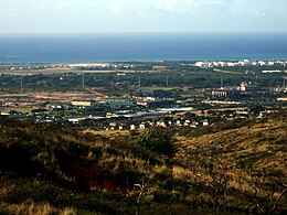 Kapolei City Center under development, taken from
Makakilo Heights
Kapolei City Center under development, taken from
Makakilo Heights
Kapolei
(
Hawaiian pronunciation:
[k?po?lej]
) is a
planned community
in
Honolulu County
,
Hawai?i
, United States, on the island of
O?ahu
. It is colloquially known as the "second city" of O?ahu,
[4]
in relation to
Honolulu
. For statistical purposes, the United States Census Bureau has defined Kapolei as a
census-designated place
(CDP) within the
consolidated city-county
of Honolulu.
The community takes its name from a
volcanic cone
,
Pu?u o Kapolei
. In the
Hawaiian language
,
pu?u
means "hill" and
Kapo lei
means "beloved Kapo". According to legend,
Kapo
, Goddess of Fertility was sister to
Pele
, Goddess of Fire and
N?maka
, Goddess of the Sea.
Much of the land is part of the estate of
industrialist
James Campbell
. Kapolei's major developer is Kapolei Property Development, a subsidiary of James Campbell Company.
[5]
Kapolei sits primarily upon former
sugarcane
and
pineapple
fields.
Demographics
[
edit
]
Historical population
| Census
| Pop.
| Note
| %±
|
|---|
| 2010
| 15,186
| | ?
|
|---|
| 2020
| 21,411
| | 41.0%
|
|---|
|
As of the 2020 census, there were 21,411 people, 6,583 housing units, and 6,822 families in the CDP. Kapolei in 2020 had a
population density
of 4,900.7 inhabitants per square mile. The racial makeup was 14.0%
White
(2,358 people), 2.5%
African American
(560), 0.0%
Native American
(40), 29.7%
Asian
(7,432), 15.8%
Pacific Islander
(3,052), and 37.2% from
two or more races
(7,623). A total of 12.9% (2,675) of the population had
Hispanic or Latino
origin.
[7]
[8]
The ancestry was 6.8%
German
, 4.1%
Irish
, 2.1%
English
, 2.0%
Portuguese
, 1.4%
Italian
, 1.3%
French
, 1.3%
Sub-Saharan African
, 1.0%
Polish
, 0.5%
Norwegian
, 0.4%
West Indian
, and 0.3%
Scottish
.
[8]
The median age was 32.7 years old. A total of 30.6% of the population were under 18, with 7.7% under 5. A total of 9.2% of the population were 65 or older, with 5.0% between the ages of 65 and 74, 3.2% between the ages of 75 and 84, and 0.9% 85 or older. The gender makeup was 50.5% female and 49.5% male.
[7]
[8]
The median household income was $116,128, with families having $121,606, married couples having $128,844, and non-families having $73,524. A total of 6.1% of the population were in poverty, with 8.9% of those under 18, 4.8% between the ages of 18 and 64, and 5.6% of people 65 or older being in poverty. The per capita income was $41,203.
[8]
[7]
History
[
edit
]
[9]
In 1955 the Kapolei master plan was drafted and revised 3 different times beginning in 1974. In 1977 the new General Provision Plan adopted the O?ahu General Plan which dubbed Kapolei "second urban center" (SUC) on the island of
O?ahu
. In 1986 the ?Ewa Master Plan was revised to include the SUC and the initial residential construction in the Kapolei area began in the late 1980s with commercial developments springing up shortly thereafter. Nearly two decades later, in 2006 the Kapolei area had more than 800 companies, agencies, and organizations making up approximately 25,000 jobs. As of the 2010 census, the Kapolei CDP had a population of 15,186 people.
[10]
The original development objectives for the City of Kapolei were to include: an employment center, a new center for offices and businesses, a center for government offices, a city of people walking, biking, or bussing, the latest energy-efficient technologies such as water conservation and recycling, and the most efficient connectivity for commuting on O?ahu. In essence a "smart city". The design plan for development ensures that the 7 themes of Kapolei remain the same throughout its construction. These include 1. Hawaiian Garden City 2. Healthy Living 3. Complete Community Services 4. Pedestrian-friendly 5. Past/Present/Future design architecture 6. Sustainability 7. Technology.
Kapolei is quickly becoming the second urban center of O?ahu, Hawai?i's most densely populated island. Much of O?ahu's future population growth is projected for the Kapolei area, ?Ewa Plain, and southern slopes of the island's central valley, between
Waipahu
near
Pearl Harbor
and
Wahiaw?
near the island's center.
The U.S.
postal code
for Kapolei is 96707. In 2002,
Pacific Business News
reported that 96707 had the second highest median income on the island of O?ahu, at $62,303.
Sperlings's Best Places
reports Kapolei's median income of $70,129, compared to the national average of $42,350. Nearly one household in five has income exceeding $100,000, with a home ownership rate of 70%.
Communities
[
edit
]
Other communities in the Kapolei area are the census-designated places of
Makakilo
and
Naval Air Station Barbers Point
(now known as
Kalaeloa
), the industrial area known as Campbell Industrial Park with the state's second largest deepwater port, Barbers Point Harbor,
[11]
and the resort and marina community of
Ko Olina
, which includes the
Disney Aulani Resort
and Ko Olina Golf Club.
Transportation
[
edit
]
Ongoing road construction has not resolved continuing traffic problems. A Manawai Street-Kama‘aha Avenue extension was completed in August 2006 and helped to reduce congestion along Kamokila Boulevard and Farrington Highway. Kapolei Property Development began construction in January 2007 on a $2 million road to extend Kamokila Boulevard from Kapolei Parkway to Roosevelt Avenue. Kapolei Property Development recently contributed $6 million for a joint project with the State Department of Transportation for an additional freeway on-ramp.
Although
state
and
county
governments and some of Hawai?i's largest companies have significant workplaces in Kapolei, population growth has far out-paced local job creation. A majority of Kapolei adults work in
Honolulu
, congesting the main traffic artery,
Interstate H-1
. In December 2006, the Honolulu City Council approved the Honolulu Rail Transit Project (now known as
Skyline
), a fixed-guideway elevated rail system connecting Kapolei to
Downtown Honolulu
. In January 2007, O?ahu residents saw an increase of 0.5 percent to the
general excise tax
to help cover the system's construction costs. The project broke ground in East Kapolei on February 22, 2011. Work on the foundations for the concrete pillars began shortly after in
Waipahu
; work to install the pillars started in East Kapolei in April 2012, and the first phase of the project started service to
Aloha Stadium
on June 30, 2023.
Main roads
[
edit
]
Kapolei is located at the southern end of the slopes of the Wai?anae mountain near the neighborhood of
Makakilo
with
Fort Barrette Road
, located along and named for historically important
Fort Barrette
, connecting Makakilo to Kapolei. It is located on the ?Ewa Plain approximately 25 miles (40 km) from Honolulu. The
Interstate H-1
freeway divides more recently developed Kapolei from Makakilo, and traveling eastward on H-1 connects to
Waipahu
. In the other direction, the freeway ends about 1 mile (1.6 km) west of Kapolei, merging into
Farrington Highway
(State Route 93) to Kahe and then to
N?n?kuli
on the
Wai‘anae Coast
. Traveling eastward on Farrington Highway connects to
Honouliuli
. Exit 1 on H-1 is Kalaeloa Boulevard, the entrance to Barbers Point and Campbell Industrial Park. Less than 1 mile beyond (west of) the merge of H-1 and Farrington Highway is an off-ramp and overcrossing to the West O?ahu resort area of Ko Olina.
To the south, Renton Road connects Kapolei to
Kalaeloa
and, further east, to
?Ewa Villages
.
Economy
[
edit
]
Ka Makana Ali‘i, a mall that opened in October 2016, has 1.4 million square feet of retail space and more than a hundred stores.
[12]
Macy's Department Store
[13]
is an anchor for the mall.
[14]
Climate
[
edit
]
- Highest temperature recorded 96 °F (36 °C) in August 2016
- Lowest temperature recorded 49 °F (9 °C) in March 2005
- Average high temperature in July, 88 °F (31 °C)
- Average low temperature in July, 69 °F (21 °C)
- Average high temperature in December, 80 °F (27 °C)
- Average low temperature in December, 60 °F (16 °C)
- Average rainfall in July, 0 inches (0 mm)
- Average rainfall in December, 3.1 inches (79 mm)
Government and infrastructure
[
edit
]
Kapolei is officially governed by the government of
Honolulu County
. The county government covers the entire island of
O?ahu
, with the county seat being at
Honolulu Hale
in
Honolulu
. The governmental body includes the
Mayor of Honolulu County
, the
Honolulu City and County Council
, and
state representatives
.
Kapolei Hale, built in 2001, serves as the
civic center
and
main municipal building
of the City of Kapolei.
[15]
The building contains an office for the Mayor, as well as offices of various city and county government agencies and is the headquarters for the City and County of Honolulu Department of Parks and Recreation.
[16]
However, the Permits Office for the Department of Parks and Recreation is located
downtown Honolulu
at the Frank F. Fasi Civic Center in the
Frank F. Fasi Municipal Building
at 650 South King Street.
[17]
[18]
[19]
[20]
[21]
[22]
[23]
Additionally, federal, several state, and county department offices have been relocated to the Kapolei area.
[11]
In 2010 the Hawai?i State Judiciary Court relocated family court matters from cramped offices in downtown Honolulu to a newly constructed, technologically advanced building in Kapolei.
[24]
The
Honolulu Police Department
operates the Kapolei Regional Police Station for district 8 at 1100 Kamokila Boulevard.
[25]
[26]
The
Federal Bureau of Investigation
(FBI) Honolulu
field office
is in Kapolei at 91-1300 Enterprise Street.
[27]
Opened in 2013, it is the first federal agency to be headquartered in Kapolei. This Honolulu field office has jurisdiction over Hawai?i,
Guam
,
Saipan
, and
American Samoa
with resident agencies in
Maui
,
Kona
, Guam, and Saipan.
[11]
[28]
[29]
The previous site in downtown Honolulu was too small.
[30]
[31]
A
coal power plant
operated until 2022. A 585
MWh
lithium iron phosphate
battery
opened in 2024.
[32]
Education
[
edit
]
The
Hawai?i Department of Education
operates public schools in Hawai?i, including Kapolei.
[33]
Public elementary schools in the Kapolei CDP include Kapolei Elementary School and Ho?okele Elementary School, with one public middle school, Kapolei Middle School, and one public high school,
Kapolei High School
.
Island Pacific Academy
(pre-K through 12) in Kapolei CDP, which opened as a private school in 2004, is an International Baccalaureate (IB) school offering IB classes to all grades. American Renaissance Academy (pre-K through 12) opened as a private school in 2007 in Kalaeloa, Naval Air Station Barbers Point.
Barbers Point Elementary School is in
Kalaeloa CDP
(formerly Barbers Point Housing CDP) but has a Kapolei address.
[34]
[35]
Makakilo Elementary School and Mauka Lani Elementary School are in
Makakilo CDP
but have Kapolei addresses.
[36]
[37]
[38]
The
University of Hawai?i ? West O?ahu
relocated to Kapolei and opened its new campus in August 2012 at 91-1001 Farrington Highway.
Hawaii Tokai International College
relocated to Kapolei in April 2015.
[39]
[40]
Wayland Baptist University
is also located in Kapolei.
[41]
See also
[
edit
]
References
[
edit
]
- ^
"Hawaii Statewide Map of 2010 CDPs"
(PDF)
.
State of Hawaii Office of Planning
. Hawaii Statewide GIS Program. p. 2
. Retrieved
4 March
2020
.
- ^
"The City of Kapolei"
. Kapolei Property Development.
- ^
"2020 U.S. Gazetteer Files"
. United States Census Bureau
. Retrieved
December 18,
2021
.
- ^
"Kapolei Skyscraper Page"
. Skyscraper Source Media
. Retrieved
2008-01-27
.
- ^
"About Us"
. Kapolei Property Development
. Retrieved
2008-01-27
.
- ^
"Census of Population and Housing"
. Census.gov
. Retrieved
June 4,
2016
.
- ^
a
b
c
"U.S. Census Bureau QuickFacts: Kapolei CDP, Hawaii"
.
www.census.gov
. Retrieved
2023-05-31
.
- ^
a
b
c
d
"Explore Census Data"
.
data.census.gov
. Retrieved
2023-05-31
.
- ^
Kapolei Urban Design Plan
- ^
"Profile of General Population and Housing Characteristics: 2010 Demographic Profile Data (DP-1): Kapolei CDP, Hawaii"
.
United States Census Bureau
. Retrieved
May 22,
2012
.
- ^
a
b
c
"Government Services in Kapolei: City and County of Honolulu, the State of Hawaii, and the Federal government of the U.S."
kapolei.com website
. Retrieved
August 7,
2018
.
- ^
Ka Makana Ali‘i
website, July 29, 2014, retrieved on July 20, 2017.
- ^
"Macy's - Clothing, Shoes, Bed & Bath, Kitchen, Beauty Brands & Sunglasses"
. February 10, 2009. Archived from
the original
on 2009-02-10.
- ^
Erika Engle, "Macy's to Anchor Kapolei Mall,"
Star Advertiser
, May 29, 2014.
- ^
"Kapolei Hale Opened"
.
City and County of Honolulu, news release
. February 8, 2001
. Retrieved
August 7,
2018
.
- ^
"About the City and County of Honolulu Department of Parks and Recreation"
.
City and County of Honolulu: Department of Parks and Recreation website
. Retrieved
August 7,
2018
.
- ^
"Rule changes for Shore Water Events go into effect: Application deadline for first triennial calendar set for September 28, 2018"
.
City and County of Honolulu: Department of Parks and Recreation website
. July 29, 2018
. Retrieved
August 7,
2018
.
- ^
"Application for Use of Parks Facilities"
(PDF)
.
City and County of Honolulu: Department of Parks and Recreation website
. Retrieved
August 7,
2018
.
- ^
"Camping Rules"
(PDF)
.
City and County of Honolulu Department of Parks and Recreation
. March 7, 2018
. Retrieved
August 7,
2018
.
- ^
"C&C of Honolulu Camping Permits"
.
City and County of Honolulu Department of Parks and Recreation website
. Retrieved
August 7,
2018
.
- ^
"Camping brochure"
(PDF)
.
Department of Parks and Recreation
. Retrieved
August 7,
2018
.
- ^
"Camping Information"
.
Department of Parks and Recreation
. Retrieved
August 7,
2018
.
- ^
Shikina, Robert (July 28, 2006).
"Fasi's imprint made permanent"
.
Honolulu Advertiser
. Retrieved
August 7,
2018
.
- ^
Chiem, Linda. "
Lawyers see new Kapolei court as long, costly drive
."
Pacific Business News
. January 31, 2010. Retrieved on September 19, 2011.
- ^
"
Contacting HPD
Archived
2010-05-31 at the
Wayback Machine
."
Honolulu Police Department
. Retrieved on May 19, 2010.
- ^
"District 8 - Kapolei/Waianae: Honolulu Police Department"
.
Honolulu Police Department (HPD)
. Retrieved
August 7,
2018
.
- ^
"
Honolulu Division
."
Federal Bureau of Investigation
. Retrieved on June 9, 2015. "91-1300 Enterprise Street Kapolei, HI 96707"
- ^
Storms, Jade (2013).
"FBI unveils new building in Kapolei"
.
Hawai'i News Now (HNN)
. Retrieved
August 7,
2018
.
- ^
"FBI Field Offices: Honolulu"
.
FBI website
. Retrieved
August 7,
2018
.
- ^
"FBI building new Honolulu Field Office"
.
Star-Advertiser
. Honolulu. Associated Press. October 19, 2010
. Retrieved
August 7,
2018
.
- ^
"FBI gets new field office on 10-acre Hawaii site"
.
Hawai'i News Now (HNN)
. Associated Press. 2013
. Retrieved
August 7,
2018
.
- ^
"Plus Power switches on 185 MW battery in Hawaii"
. 12 January 2024.
- ^
"2010 CENSUS - CENSUS BLOCK MAP: Kapolei CDP, HI"
(PDF)
.
U.S. Census Bureau
. Retrieved
2020-10-10
.
- Compare this map to addresses of schools to see which ones are in the CDP.
- ^
"Contact"
. Barbers Point Elementary School
. Retrieved
2020-10-10
.
Address: 3001 Boxer Road Kapolei, HI 96707
- ^
"2010 CENSUS - CENSUS BLOCK MAP: Kalaeloa CDP, HI"
(PDF)
.
U.S. Census Bureau
. Retrieved
2020-10-10
.
2000 map:
"CENSUS 2000 BLOCK MAP: BARBERS POINT HOUSING CDP"
(PDF)
.
U.S. Census Bureau
. Retrieved
2020-10-10
.
- ^
"2010 CENSUS - CENSUS BLOCK MAP: Makakilo CDP, HI"
(PDF)
.
U.S. Census Bureau
. Retrieved
2020-10-10
.
2000 map:
"CENSUS 2000 BLOCK MAP: MAKAKILO CITY CDP"
(PDF)
.
U.S. Census Bureau
. Retrieved
2020-10-10
.
- ^
"Home"
. Makakilo Elementary School
. Retrieved
2020-10-10
.
92-675 Anipeahi Street, Kapolei, HI 96707
- ^
"Home"
. Mauka Lani Elementary School
. Retrieved
2020-10-10
.
92-1300 Panana Street, Kapolei, HI 96707
- ^
"University of Hawai?i ? West O?ahu"
.
University of Hawai?i ? West O?ahu website
. Retrieved
August 7,
2018
.
- ^
"University of Hawai?i News: Public invited to West O?ahu campus grand opening"
.
University of Hawai?i website
. August 16, 2012
. Retrieved
August 7,
2018
.
- ^
[1]
, Wayland Baptist University Website, retrieved on April 9, 2018. "599 Farrington Highway, Suite 300 Kapolei, HI 96707 "
External links
[
edit
]
Wikivoyage has a travel guide for
Kapolei
.
|
|---|
|
| CDPs
| |  Map of Hawaii highlighting Honolulu County Map of Hawaii highlighting Honolulu County
|
|---|
Other
communities
| |
|---|
| Government
| | Elected officials
| |
|---|
| Departments
| |
|---|
|
|---|
|
|
|---|
| International
| |
|---|
| National
| |
|---|
| Geographic
| |
|---|