Region between Euphrates and Tigris
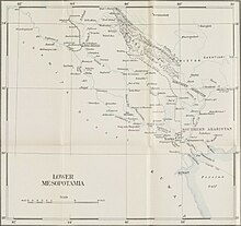 A map of Lower Mesopotamia from 1924
Lower Mesopotamia
[1]
[2]
is a
historical region
of
Mesopotamia
. It is located in the
alluvial plain
of
Iraq
from the
Hamrin Mountains
to the
Faw Peninsula
near the
Persian Gulf
.
In the Middle Ages it was also known as the
Sawad
and al-Jazira al-sflia ("Lower Jazira"), which strictly speaking designated only the southern alluvial plain,
and
Arab Iraq
, as opposed to
Persian Iraq
, the
Jibal
.
[4]
Lower Mesopotamia was home to
Sumer
and
Babylonia
.
[5]
Delimitation
[
edit
]
The medieval Arab geographers placed the northern border between Iraq and
Upper Mesopotamia
(the
Jazirah
) in a line running from
Anbar
on the Euphrates to
Tikrit
on the
Tigris
, although later it was shifted to a line running due west from Tikrit, thus including several towns on the Euphrates past Anbar into Iraq.
Geography
[
edit
]
An
alluvial plain
begins north of
Tikrit
Near
Hamrin Mountains
and extends to the
Persian Gulf
. Here the
Tigris
and
Euphrates
lie above the level of the plain in many places, and the whole area is a
river delta
interlaced by the channels of the two rivers and by
qanat
. Intermittent
lakes
, fed by the rivers in flood, also characterize southeastern Iraq. A fairly large area (15,000 km
2
or 5,800 sq mi) just above the confluence of the two rivers at
al Qurnah
and extending east of the Tigris beyond the Iranian border is marshland, known as
Lake Hammar
, the result of centuries of flooding and inadequate drainage. Much of it is permanent marsh, but some parts dry out in early winter, and other parts become marshland only in years of great flood.
Because the waters of the Tigris and Euphrates above their confluence are heavily
silt
-laden,
irrigation
and fairly frequent flooding deposit large quantities of silty loam in much of the delta area. Windborne silt contributes to the total deposit of sediments. It has been estimated that the delta plains are built up at the rate of nearly twenty centimeters in a century. In some areas, major floods lead to the deposit in temporary lakes of as much as thirty centimeters of mud.
The Tigris and Euphrates also carry large quantities of
salts
. These, too, are spread on the land by sometimes excessive irrigation and flooding. A high
water table
and poor surface and subsurface drainage tend to concentrate the salts near the surface of the soil. In general, the salinity of the soil increases from Baghdad south to the Persian Gulf and severely limits productivity in the region south of
Amarah
. The
salinity
is reflected in the large lake in central Iraq, southwest of Baghdad, known as
Lake Milh
. There are two other major lakes in the country to the north of Lake Milh:
Lake Tharthar
and
Lake Habbaniyah
.
See also
[
edit
]
References
[
edit
]
Sources
[
edit
]