Highway in Alabama
This article is about the section of Interstate 65 in Alabama. For the entire route, see
Interstate 65
.

Interstate 65
|
|---|
I-65 highlighted in red
|
|
| Maintained by
ALDOT
|
| Length
| 366.229 mi
[1]
(589.388 km)
|
|---|
| NHS
| Entire route
|
|---|
|
| South end
|  I-10
in
Mobile I-10
in
Mobile
|
|---|
| Major intersections
| |
|---|
| North end
|   I-65
/
US 31
at
Tennessee
state line I-65
/
US 31
at
Tennessee
state line
|
|---|
|
|
|---|
|
| Country
| United States
|
|---|
| State
| Alabama
|
|---|
| Counties
| Mobile
,
Baldwin
,
Escambia
,
Conecuh
,
Butler
,
Lowndes
,
Montgomery
,
Elmore
,
Autauga
,
Chilton
,
Shelby
,
Jefferson
,
Blount
,
Cullman
,
Morgan
,
Limestone
|
|---|
|
|
|---|
|
- Alabama State Highway System
|
|
Interstate 65
(
I-65
) meanders across 366 miles (589 km) of the
Alabama
countryside linking six of the state's 10 largest cities. The highway links together many important roadways that make commerce inside and outside of the state's boundaries possible. It starts at
I-10
near
Mobile
. The route passes through the major cities of
Montgomery
,
Birmingham
,
Decatur
,
Huntsville
, and
Athens
before entering
Tennessee
in the north near the town of
Ardmore, Alabama
.
The entire Alabama portion of I-65 is dedicated as Heroes Highway in honor of Central Intelligence Agency officer
Johnny Micheal Spann
and all of the people who died during the
September 11 attacks
.
[2]
Route description
[
edit
]
 Southern terminus at I-10 in Mobile
I-65 starts its northward journey in Mobile as a three-lane freeway at a
directional Y interchange
with
I-10
not far from the
Gulf of Mexico
. From there, it runs northeast, intersecting with
I-165
in
Prichard
. At exit 13 in
Saraland
, the Interstate transitions from three to two lanes. The highway next crosses the
Mobile?Tensaw River Delta
at the
General W.K. Wilson Jr. Bridge
. En route to
Montgomery
, it passes county seats
Evergreen
(
Conecuh County
) and
Greenville
(
Butler County
). In the case of a hurricane evacuation on Alabama's coast, I-65 can be converted to an evacuation route where all lanes flow in the northbound direction from Mobile to Montgomery. This process is known as
contraflow
. The terrain on this stretch of road is slightly hilly, aside from a stretch in southern Conecuh County near
Castleberry
, where the road is slightly mountainous as it descends over 400 feet (120 m) into the southern plains of Alabama.
 Billboard along I-65 north, north of Prattville and just south of milemarker 191
[3]
Billboard along I-65 north, north of Prattville and just south of milemarker 191
[3]
As the I-65 approaches the Montgomery city limits, the
Hyundai Motor Company
's automotive plant can be found just off freeway. It can be accessed using the
Pintlala
?
Hope Hull
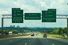
exit (exit 164). After entering the city limits, I-65 intersects
U.S. Route 80
(US 80, exit 167; which leads to
Selma
toward the west) where the Interstate gains an additional lane for a total of three lanes in each direction. Further on, it intersects the southern terminus of
I-85
and crosses the
Alabama River
north of the city. At exit 181, which provide access to
Prattville
and
Wetumpka
, I-65's lanes drop to two.
At
Chilton County
, I-65 enters the
Birmingham metropolitan area
. Approximately halfway between Montgomery and Birmingham, it passes
Clanton
, the county seat, where the water tower, visible from the road, is shaped and painted to resemble a huge
peach
. Between exit 212 (
State Route 145
(SR 145)) and exit 219 (County Road 42), I-65 was designated "War on Terror Memorial Highway" in 2014.
I-65 junctions with
US 31
(exit 238) in
Alabaster
, where the Interstate carries three to four lanes until
I-20
/
I-59
. I-65 intersects
I-459
in
Hoover
, then passes through the cities of
Vestavia Hills
and
Homewood
, which often generate heavy traffic. As the Interstate passes by downtown Birmingham, southbound travelers have a view of the
Vulcan statue
atop
Red Mountain
. At the north edge of downtown, I-65 reaches the I-20/I-59 intersection (exit 261) with a crossover interchange, often called "
Malfunction Junction
", through which the highway has five lanes, continuing on northward with four.
 I-65 south approaching Birmingham and Malfunction Junction
North of Birmingham at mile 266, interchange ramps provide access to parallel US 31. It is here that I-65 meets the eastern terminus of
I-22
, which heads northwest to Memphis, Tennessee, filling in a gap in the
Interstate Highway System
. After which, I-65 intersects Walker Chapel Road (exit 267) in
Fultondale
, where the Interstate drops to three lanes. The Interstate then continues 98 miles (158 km) in the general direction of
Huntsville
, crossing the
Blount
?
Cullman
county line (milemarker 291), where lanes transition from three to two, as well as passing the city of
Cullman
on the way. After entering the
Decatur metropolitan area
, in southern
Morgan County
, the Interstate passes
Decatur
. The highway connects the
Huntsville?Decatur metropolitan area
as it crosses
Wheeler Lake
(
Tennessee River
) on a 2.6-mile (4.2 km) bridge. The Interstate emerges again into the fringes of Decatur in an open area of seemingly "endless" cotton fields where it intersects, inside Decatur, with
SR 20
,
U.S. Route 72 Alternate
(US 72 Alt.), and the spur route
I-565
to Huntsville.
Between Walkers Chapel Road in Fultondale and the Tennessee River in Decatur (
Limestone County
), I-65 has been designated the "Ronald Reagan Memorial Highway". The sign designating the north end of this portion of road cites Reagan's speech in Decatur on July 4, 1984. The Interstate then continues, passing
Athens
, and merges with US 31. The two routes travel concurrently approximately 12 miles (19 km) to the Tennessee state line.
In the Birmingham?Hoover vicinity, a plan to widen the Interstate from
North Birmingham
to Alabaster has been proposed.
[4]
The project is to widen the Interstate by adding an
HOV
lane and keeping the original three lanes making it four lanes in each direction.
[5]
This is planned to stretch to the
Pelham
area. From there, the Interstate will widen from two lanes each way to three lanes each way into the
Helena
?Alabaster area.
 I-65 south Alabama Welcome Center and rest area with the Saturn IB rocket
Near the northern border of Alabama with Tennessee on southbound I-65 is located the Alabama Welcome Center and rest area. The unique feature of this rest area compared to others is the large
Saturn IB
rocket erected on the site as a memorial to Alabama's?and, in particular, Huntsville's?contribution to
NASA
's space exploration.
[6]
 I-65 between Birmingham and Decatur near milemarker 277
History
[
edit
]
The first section designed for the future Interstate Highway System spanned from the Tennessee border to Athens at US 31. It opened on November 15, 1958, and has a historical marker on the Tennessee side of the border. It was converted to full Interstate standards around 1970.
[
citation needed
]
The first section of Interstate in Alabama opened to traffic was the eight-mile (13 km) stretch of I-65 between northern Jefferson County and
Warrior
on December 10, 1959.
[7]
A 26-mile (42 km) segment between Clanton and
Calera
opened to traffic on March 23, 1961.
[8]
On April 1, 1961, a 26-mile (42 km) section between north of Warrior and
SR 69
near Cullman opened to traffic.
[9]
On May 25, 1961, two segments of I-65, a 14-mile (23 km) segment near Clanton and a six-mile (9.7 km) segment between Calera and Alabaster, were opened.
[8]
In Mobile, the 6.8-mile (10.9 km) section between
US 90
and
US 45
opened on January 4, 1963.
[10]
Work on the Tennessee River bridges in Morgan and Limestone counties began in April 1969, and the bridges were dedicated and opened on November 21, 1973.
[11]
 I-65 under construction in Escambia County in 1963
While most of I-65 in Alabama was completed in the 1960s, the last segments to be completed were some of the last segments to be completed on the entire Interstate Highway System. The 11.7-mile (18.8 km) section between Alabaster and Hoover opened on May 20, 1981.
[12]
The first contracts for the construction of the 12-mile (19 km) segment between
US 43
north of Mobile and
SR 225
in Baldwin County, including the six-mile-long (9.7 km) General W.K. Wilson Jr. Bridge, were awarded in 1967, and the section was opened on October 2, 1981.
[13]
At the time, this was the most expensive highway project in the state's history, costing $137 million (equivalent to $389 million in 2023
[14]
).
[13]
The last section to be completed was a 14-mile (23 km) section between Lewisberg and Warrior that opened on December 19, 1985, which replaced a four-lane section of US 31 that had been designated as part of I-65 but did not meet Interstate Highway standards.
[15]
In 1997, at
Georgiana
(exit 114), honoring legendary country musician and Alabama native
Hank Williams
, the Interstate was designated as Hank Williams's Memorial "Lost Highway", after one of his songs. This designation continues northward until mile 179 north of Montgomery. From the state's capital, I-65 doglegs northward, bypassing
Prattville
and
Clanton
before going through the
Birmingham metropolitan area
. From exits 242 to 290, this highway carries at least six lanes of traffic. A portion of the Interstate running through Birmingham has been nicknamed "Malfunction Junction" for its numerous wrecks. These accidents include two separate occasions of the support beams melting after crashes by 18-wheelers and the numerous collisions that happen every year, resulting from the junction with I-20 and I-59.
In 2004, following the death of former-
President
Ronald Reagan
, a lengthy segment of I-65 from
Jefferson County
to
Limestone County
was designated the Ronald Reagan Memorial Highway. The sign designating the north end of the segment includes a statement from Reagan's speech at
Point Mallard Park
in nearby Decatur on July 4, 1984.
Future
[
edit
]
Just a few miles north of I-22 will be the new interchange (exit 274), which will be
Corridor X-1
and has been designated as
Interstate 422
. This loop route will connect I-65 with I-59 northeast of Birmingham and I-20/I-59 southwest of Birmingham, and this will serve as an Interstate Highway bypass of Birmingham, augmenting the existing I-459, which already provides the southern loop of Birmingham. Construction of this interchange is still several years away, but right-of-way is in the process of being acquired to build I-422. I-65 will also be widened between exit 231 in
Calera
and exit 238 near
Alabaster
, which will include six bridges over rail tracks and two bridges. This project is expected to cost $300 million.
[16]
Exit list
[
edit
]
See also
[
edit
]
References
[
edit
]
- ^
"FHWA Route Log and Finder List: Table 1"
.
Federal Highway Administration
. Retrieved
October 4,
2014
.
- ^
"Heroes Highway of Alabama"
. Montgomerygop.net. Archived from
the original
on May 13, 2008
. Retrieved
August 5,
2009
.
- ^
Simon, Scott (July 23, 2005).
"Alabama Billboard's Message Changes"
.
All Things Considered
. NPR. Archived from
the original
on July 14, 2007
. Retrieved
July 26,
2013
.
- ^
Snyder, Sarah (February 14, 2011).
"Planning commission proposes carpool lane on I65"
.
WBMA
. Retrieved
September 3,
2022
.
- ^
"Interstate 65/US 31 Mobility Matters Project: Executive Summary"
(PDF)
.
Regional Planning Commission of Greater Birmingham
. November 1, 2011.
Archived
(PDF)
from the original on January 19, 2022
. Retrieved
September 11,
2022
.
- ^
Hughes, Bayne (April 6, 2014).
"Iconic rocket due for repair"
.
Decatur Daily
. Retrieved
April 8,
2014
.
- ^
Stanton, Allison (December 11, 1959).
"State's road program rolls right along"
.
The Birmingham News
. p. 18
. Retrieved
August 18,
2020
– via Newspapers.com.
- ^
a
b
Badger, Eddie (May 23, 1961).
"$266 million in road spending predicted"
.
The Birmingham News
. Retrieved
August 18,
2020
– via Newspapers.com.
- ^
"Interstate Road Section Near Cullman Is Opening Saturday"
.
The Decatur Daily
. March 31, 1961
. Retrieved
August 18,
2020
– via Newspapers.com.
- ^
"Mobile dedicates urban road link"
.
The Montgomery Advertiser
. January 4, 1963
. Retrieved
August 18,
2020
.
- ^
"Wallace Calls New Interstate Bridge 'Step Forward'
"
.
The Tennessean
. Nashville, Tennessee. United Press International. November 22, 1973. p. 79
. Retrieved
August 18,
2020
– via Newspapers.com.
- ^
"Hoover-Alabaster I-65 leg opened as commuters wait"
.
The Montgomery Advertiser
. Associated Press. May 21, 1981. p. 21
. Retrieved
August 18,
2020
.
- ^
a
b
"James opens final leg of interstate to Mobile"
.
The Montgomery Advertiser
. Associated Press. October 3, 1981
. Retrieved
August 18,
2020
– via Newspapers.com.
- ^
Johnston, Louis; Williamson, Samuel H. (2023).
"What Was the U.S. GDP Then?"
.
MeasuringWorth
. Retrieved
November 30,
2023
.
United States
Gross Domestic Product deflator
figures follow the
MeasuringWorth
series.
- ^
"Highway official says I-65 delays may have benefited Birmingham".
The Gadsden Times
. December 19, 1985.
- ^
Turner, Alyssa (August 31, 2023).
"Governor Ivey Announces Widening of I-65, Hoover Interchange Project and Widening of I-59"
.
Office of the Governor of Alabama
. Retrieved
September 5,
2023
.
- ^
"Milepost/General Highway Maps"
.
Alabama Department of Transportation
. Archived from
the original
on April 2, 2015
. Retrieved
April 14,
2016
.
External links
[
edit
]
KML is from Wikidata