Imaginary line that demarcates the change of one calendar day to the next
 The International Date Line around the
antimeridian
(180° longitude).
The International Date Line around the
antimeridian
(180° longitude).
The
International Date Line
(
IDL
) is the line between the
South
and
North Poles
that is the boundary between one
calendar day
and the next. It passes through the
Pacific Ocean
, roughly following the
180.0°
line of longitude
and deviating to pass around some territories and island groups. Crossing the date line eastbound decreases the date by one day, while crossing the date line westbound increases the date.
The line is a
cartographic
convention, and is not defined by international law. This has made it difficult for cartographers to agree on its precise course, and has allowed countries through whose waters it passes to move it at times for their convenience.
[1]
Geography
[
edit
]
 A simplified illustration of the relation between date line, date and time of day. Each colour represents a different date.
 Example depicting situation at 04:00
GMT
Tuesday. (Times are approximate, since time zone boundaries generally do not exactly coincide with meridians. Night and day is illustrative only; daylight hours depend on latitude and time of year.)
Example depicting situation at 04:00
GMT
Tuesday. (Times are approximate, since time zone boundaries generally do not exactly coincide with meridians. Night and day is illustrative only; daylight hours depend on latitude and time of year.)
Circumnavigating the globe
[
edit
]
People traveling westward
around the world
must set their clocks:
- Back by one hour for every 15° of longitude crossed, and
- Forward by 24 hours upon crossing the International Date Line.
People traveling eastward must set their clocks:
- Forward by one hour for every 15° of longitude crossed, and
- Back by 24 hours upon crossing the International Date Line.
Failing to do this would make their time inaccurate to the local time.
The 14th century Arab geographer
Abulfeda
predicted that circumnavigators would accumulate a one-day offset to the local date.
[2]
This phenomenon was confirmed in 1522 at the end of the
Magellan?Elcano expedition
, the first successful circumnavigation. After sailing westward around the world from Spain, the expedition called at
Cape Verde
for provisions on Wednesday, 9 July 1522 (ship's time). However, the locals told them that it was actually Thursday, 10 July 1522. The crew was surprised, as they had recorded each day of the three-year journey without omission.
[3]
Cardinal
Gasparo Contarini
, the Venetian ambassador to Spain, was the first European to give a correct explanation of the discrepancy.
[4]
Description
[
edit
]
- This description is based on the most common understanding of the
de facto
International Date Line. See
§ De facto and de jure date lines
below, and map above at right.
The IDL is roughly based on the
meridian
of 180° longitude, roughly down the middle of the Pacific Ocean, and halfway around the world from the
IERS Reference Meridian
, the successor to the historic
Greenwich prime meridian
running through the
Royal Greenwich Observatory
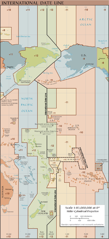
. In many places, the IDL follows the 180° meridian exactly. In other places, however, the IDL deviates east or west away from that meridian. These various deviations generally accommodate the political and/or economic affiliations of the affected areas.
Proceeding from north to south, the first deviation of the IDL from 180° is to pass to the east of
Wrangel Island
and the
Chukchi Peninsula
, the easternmost part of Russian
Siberia
. (Wrangel Island lies directly on the meridian at 71°32′N 180°0′E, also noted as 71°32′N 180°0′W.)
[5]
It then passes through the
Bering Strait
between the
Diomede Islands
at a distance of 1.5 kilometres (0.93 mi) from each island at 168°58′37″ W.
[6]
It then bends considerably west of 180°, passing west of
St. Lawrence Island
and
St. Matthew Island
.
The IDL crosses between the U.S.
Aleutian Islands
(
Attu Island
being the westernmost) and the
Commander Islands
, which belong to Russia. It then bends southeast again to return to 180°. Thus, all of Russia is to the west of the IDL, and all of the United States is to the east except for the insular areas of
Guam
, the
Northern Mariana Islands
, and
Wake Island
, reaching the hypothetical, but not used UTC?13:00 time zone.
The IDL remains on the 180° meridian until passing the
equator
. Two U.S.-owned uninhabited atolls,
Howland Island
and
Baker Island
, just north of the equator in the central Pacific Ocean (and ships at sea between 172.5°W and 180°), have the earliest time on Earth (
UTC?12:00
hours).
The IDL circumscribes
Kiribati
by swinging far to the east, almost reaching the
150°W meridian
. Kiribati's easternmost islands, the southern
Line Islands
south of
Hawaii
, have the latest time on Earth,
UTC+14:00
hours.
South of Kiribati, the IDL returns westwards but remains east of 180°, passing between
Samoa
and
American Samoa
.
[7]
Accordingly, Samoa,
Tokelau
,
Wallis and Futuna
,
Fiji
,
Tonga
,
Tuvalu
, and New Zealand's
Kermadec Islands
and
Chatham Islands
are all west of the IDL and have the same date. American Samoa, the
Cook Islands
,
Niue
, and
French Polynesia
are east of the IDL and one day behind.
The IDL then bends southwest to return to 180°. It follows that meridian until reaching
Antarctica
, which has
multiple time zones
. Conventionally, the IDL is not drawn into Antarctica on most maps. (See
§ Cartographic practice and convention
below.)
Facts dependent on the IDL
[
edit
]
According to the clock, the first areas to experience a new day and a
New Year
are islands that use UTC+14:00. These include portions of the
Republic of Kiribati
, including
Millennium Island
in the Line Islands. The first major cities to experience a new day are
Auckland
and
Wellington
, New Zealand (
UTC+12:00
;
UTC+13:00
with daylight saving time).
[
citation needed
]
A 1994 realignment of the IDL made Caroline Island one of the first points of land on Earth to reach January 1, 2000, on the calendar (UTC+14:00). As a result, this
atoll
was renamed
Millennium Island
.
[8]
The areas that are the first to see the daylight of a new day vary by the season. Around the
June solstice
, the first area would be any place within the
Kamchatka Time Zone
(UTC+12:00) that is far enough north to experience
midnight sun
on the given date. At the
equinoxes
, the first place to see daylight would be the uninhabited Millennium Island in Kiribati, which is the easternmost land located west of the IDL.
[
citation needed
]
Near the
December solstice
, the first places would be
Antarctic research stations
using
New Zealand Time
(UTC+13:00) during summer that experience midnight sun. These include
Amundsen-Scott South Pole Station
,
McMurdo Station
,
Scott Base
and
Zucchelli Station
.
[9]
De facto and de jure date lines
[
edit
]
There are two ways
time zones
and thereby the location of the International Date Line are determined, one on land and adjacent
territorial waters
, and the other on open seas.
[
citation needed
]
All nations unilaterally determine their standard
time zones
, applicable only on land and adjacent territorial waters. This date line can be called
de facto
since it is not based on international law, but on national laws. These national zones do not extend into international waters.
[
citation needed
]
The
nautical date line
, not the same as the IDL, is a
de jure
construction determined by international agreement. It is the result of the 1917
Anglo-French Conference on Time-keeping at Sea
, which recommended that all ships, both military and civilian, adopt hourly standard time zones on the high seas. The United States adopted its recommendation for U.S. military and merchant marine ships in 1920. This date line is implied but not explicitly drawn on time zone maps. It follows the
180° meridian
except where it is interrupted by territorial waters adjacent to land, forming gaps?it is a pole-to-pole dashed line. The 15°
gore
that is offset from UTC by 12 hours is bisected by the nautical date line into two 7.5° gores that differ from UTC by ±12 hours.
In theory, ships are supposed to adopt the standard time of a country if they are within its territorial waters within 12 nautical miles (14 mi; 22 km) of land, then revert to international time zones (15° wide pole-to-pole
gores
) as soon as they leave. In practice, ships use these time zones only for radio communication and similar purposes. For internal (within-ship) purposes, such as work and meal hours, ships use a time zone of their own choosing.
[
citation needed
]
Cartographic practice and convention
[
edit
]
The IDL on the map in this article and all other maps is based on the
de facto
line and is an artificial construct of cartographers, as the precise course of the line in international waters is arbitrary. The IDL does not extend into Antarctica on the world time zone maps by the United States
Central Intelligence Agency
(CIA)
[10]
or the United Kingdom's
His Majesty's Nautical Almanac Office
(HMNAO).
[11]
The IDL on modern CIA maps now reflects the most recent shifts in the IDL
[10]
(see
§ Historic alterations
below). The current HMNAO map does not draw the IDL in conformity with recent shifts in the IDL; it draws a line virtually identical to that adopted by the UK's Hydrographic Office about 1900.
[12]
Instead, HMNAO labels island groups with their time zones, which do reflect the most recent IDL shifts.
[11]
This approach is consistent with the principle of national and nautical time zones: the islands of eastern Kiribati are actually "islands" of Asian date (west side of IDL) in a sea of American date (east side of IDL). Similarly, the western Aleutian Islands are islands of American date in a sea of Asian date.
[
citation needed
]
No international organization, nor any treaty between nations, has fixed the IDL drawn by cartographers: the 1884
International Meridian Conference
explicitly refused to propose or agree to any time zones, stating that they were outside its purview. The conference resolved that the Universal Day, midnight-to-midnight
Greenwich Mean Time
(now redefined and updated as
Coordinated Universal Time, or UTC
), which it did agree to, "shall not interfere with the use of local or standard time where desirable".
[13]
From this comes the utility and importance of UTC or "Z" ("Zulu") time: it permits a single universal reference for time that is valid for all points on the globe at the same moment.
[
citation needed
]
Historic alterations
[
edit
]
Philippines (1521 and 1844)
[
edit
]
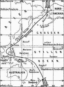 Erroneous International Date Line from the 1888 Encyclopædia the
Meyers Konversations-Lexikon
, running between the Spanish
Philippine Islands
and British
Hong Kong
. The Philippine Islands and the rest of
New Spain
are shown on the eastern side of the IDL, even though they were moved to the western side in 1845. Also placed to the east of the IDL were the
Bonin Islands
and
Fiji
, which are actually to the west of the line.
Erroneous International Date Line from the 1888 Encyclopædia the
Meyers Konversations-Lexikon
, running between the Spanish
Philippine Islands
and British
Hong Kong
. The Philippine Islands and the rest of
New Spain
are shown on the eastern side of the IDL, even though they were moved to the western side in 1845. Also placed to the east of the IDL were the
Bonin Islands
and
Fiji
, which are actually to the west of the line.
Ferdinand Magellan
claimed the Philippines for Spain on Saturday,
16 March 1521
, having sailed westwards from
Seville
across the
Atlantic Ocean
and the
Pacific Ocean
. As part of
New Spain
, the
Philippines
had its most important communication with
Acapulco
in
Mexico
, so it was on the eastern side of the IDL despite being on the western edge of the
Pacific Ocean
. As a result, the Philippines was one day behind its
Asian
neighbours for 323 years, 9 months and 4 days from Saturday, 16 March 1521
(Julian Calendar)
until Monday, 30 December 1844
(Gregorian Calendar)
.
[14]
After Mexico gained its independence from Spain on 27 September 1821, Philippine trade interests turned to
Imperial China
, the
Dutch East Indies
and adjacent areas, so the Philippines decided to join its Asian neighbours on the west side of the IDL.
[15]
[
self-published source
]
To advance the calendar by one day, on 16 August 1844 the then governor-general
Narciso Claveria
, ordered that Tuesday,
31 December 1844
should be removed from the calendar. Monday,
30 December 1844
was followed immediately by Wednesday,
1 January 1845
. The change also applied to the other remaining Spanish colonies in the Pacific: the
Caroline Islands
,
Guam
,
Mariana Islands
,
Marshall Islands
and
Palau
as part of the
Captaincy General of the Philippines
.
[16]
[17]
Western publications were generally unaware of this change until the early 1890s, so they erroneously gave the International Date Line a large western bulge for the next half century.
[18]
Tahiti & French Polynesia (early 1797 and late 1846)
[
edit
]
On 5 March 1797, missionaries of the
London Missionary Society
arrived on
Tahiti
from England. They had first tried to pass
Cape Horn
, but failing that, went along
Cape of Good Hope
and the
Indian Ocean
instead. As such, they introduced the date of the eastern hemisphere on the island.
[19]
It was not until the ending of the
Franco-Tahitian War
and the restoration of the French
Protectorate
over the Tahitian Kingdom (which Tahitian nationalists had tried to fight off for two years of intense war with more than 1000 deaths) that the French commissioner
Armand Joseph Bruat
and the regent of the Tahitian Kingdom Paraita ordered that Tahiti had to follow the western hemisphere on 29 December 1846.
[20]
[21]
[22]
Alaska (1867)
[
edit
]
Alaska was on the western side of the International Date Line, since Russian settlers reached Alaska from
Siberia
. In addition, the
Russian Empire
was still using the
Julian calendar
, which had fallen 12 days behind the
Gregorian calendar
. In 1867, the United States purchased
Russian America
and moved the territory to the east side of the International Date Line. The transfer ceremony took place at 3:30
p.m. local mean time (00:31 GMT) in the capital of New Archangel (
Sitka
), on Saturday,
7 October 1867
(Julian), which was Saturday,
19 October 1867
(Gregorian) in Europe. Since Alaska moved to the eastern side of the International Date Line, the date and time also moved back to 3:30
p.m. local time Friday,
18 October 1867
(00:31 GMT Saturday), now known as
Alaska Day
.
[23]
[24]
Samoan Islands and Tokelau (1892 and 2011)
[
edit
]
The
Samoan Islands
, now divided into
Samoa
and
American Samoa
, were on the west side of the IDL until 1892. In that year, King
M?lietoa Laupepa
was persuaded by American traders to adopt the American date (three hours behind California) to replace the former Asian date (four hours ahead of Japan). The change was made by repeating
Monday, 4 July 1892
,
American Independence Day
.
[25]
In 2011, Samoa shifted back to the west side of the IDL by removing Friday,
30 December 2011
from its calendar.
[26]
This changed the time zone from
UTC?11:00
to
UTC+13:00
(
UTC-10
to
UTC+14
Dst
).
[27]
Samoa made the change because
Australia
and
New Zealand
have become its biggest trading partners, and also have large communities of expatriates. Being 21 hours behind made business difficult because having weekends on backward days meant only four days of the week were shared
workdays
.
[28]
The IDL now passes between Samoa and American Samoa, which remains on the east (American) side of the line.
[29]
Tokelau
is a territory of New Zealand north of Samoa whose principal transportation and communications links with the rest of the world pass through
Samoa
. For that reason, Tokelau crossed the IDL along with Samoa in 2011, albeit strictly speaking 1 hour later, as they did not do Summer Time (Daylight Saving Time in American English), which Samoa did then.
[30]
Kwajalein (c. 1945 and 1993)
[
edit
]
Kwajalein
atoll, like the rest of the
Marshall Islands
, passed from Spanish to German to Japanese control during the nineteenth and twentieth centuries. During that period it was west of the IDL. Although Kwajalein formally became part of the
Trust Territory of the Pacific Islands
with the rest of the Marshalls after World War II, the United States established a military installation there. Because of that, Kwajalein used the Hawaiian date, so was effectively east of the International Date Line (unlike the rest of the Marshalls). Kwajalein returned to the west side of the IDL by removing Saturday,
21 August 1993
from its calendar. Moreover, Kwajalein's work week was changed to Tuesday through Saturday to match the Hawaiian work week of Monday through Friday on the other side of the IDL.
[31]
Eastern Kiribati (1994)
[
edit
]
As a British colony, the
Kiribati
colony was centered in the
Gilbert Islands
, just west of the IDL of the time. Upon independence in 1979, it acquired the claim to the
Phoenix
and
Line Islands
, east of the IDL, from the United States. As a result, the country straddled the IDL. Government and commercial concerns on opposite sides of the line could only conduct routine business by radio or telephone on the four days of the week which were weekdays on both sides. To eliminate this anomaly,
Kiribati
introduced a change of date for its eastern half by removing Saturday,
31 December 1994
from its calendar. Because of this, Friday, 30 December 1994, was followed by Sunday, 1 January 1995. After the change, the IDL in effect moved eastwards to go around the entire country. Strictly legal, the 1917 nautical IDL convention is still valid. For example, when it is Monday on Kiribati's islands, it is still Sunday in the surrounding ocean, though maps are usually not drawn this way.
[32]
As a consequence of the 1994 change, Kiribati's easternmost territory, the
Line Islands
, including the inhabited island of
Kiritimati (Christmas Island)
, started the year 2000 before any other country, a feature upon which the Kiribati government capitalized as a potential tourist draw.
[
citation needed
]
Date lines according to religious principles
[
edit
]
Christianity
[
edit
]
Generally, the Christian calendar and Christian churches recognize the IDL.
Christmas
for example, is celebrated on 25 December (according to either the
Gregorian
or the
Julian calendar
, depending upon which of the two is used by the particular church) as that date falls in countries located on either side of the IDL. Thus, whether it is Western Christmas or Orthodox Christmas, Christians in Samoa, immediately west of the IDL, will celebrate the holiday a day before Christians in
American
Samoa, which is immediately
east
of the IDL.
[
citation needed
]
A problem with the general rule above arises in certain Christian churches that solemnly observe a Sabbath day as a particular day of the week, when those churches are located in countries near the IDL. Notwithstanding the difference in dates, the same sunrise happened over American Samoa as happens over Samoa a few minutes later, and the same sunset happens over Samoa as happened over American Samoa a few minutes earlier. In other words, the secular days are
legally
different but they are
physically
the same; that causes questions to arise under religious law.
[
citation needed
]
Because the IDL is an arbitrary imposition, the question can arise as to which Saturday on either side of the IDL (or, more fundamentally, on either side of 180 degrees longitude) is the "real" Saturday. This issue (which also arises in
Judaism
) is a particular problem for Seventh Day Adventists,
Seventh Day Baptists
, and similar churches located in countries near the IDL.
[
citation needed
]
In
Tonga
,
Seventh Day Adventists
(who usually observe Saturday, the
seventh-day Sabbath
) observe Sunday because Tonga lies east of the 180° meridian. Sunday as observed in Tonga (west of the IDL, as with Kiribati, Samoa, and parts of Fiji and Tuvalu) is considered by the Seventh-day Adventist Church to be the same day as Saturday observed east of the IDL.
[33]
[34]
Most Seventh Day Adventists in
Samoa
planned to observe Sabbath on Sunday after Samoa's crossing the IDL in December 2011, but SDA groups in Samatau village and other places (approximately 300 members) decided to accept the IDL adjustment and observe the Sabbath on Saturday.
[35]
Debate continues within the Seventh-day Adventist community in the Pacific as to which day is really the seventh-day Sabbath.
[
citation needed
]
The Samoan Independent Seventh-day Adventist Church, which is not affiliated to the worldwide Seventh-day Adventist Church, has decided to continue worshiping on Saturday, after a six-day week at the end of 2011.
[
citation needed
]
Islam
[
edit
]
The
Islamic calendar
and
Muslim
communities recognize the convention of the IDL. In particular, the day for holding the
Jumu'ah
prayer appears to be local Friday everywhere in the world.
[a]
The IDL is not a factor in the start and end of Islamic lunar months. These depend solely on sighting the
new crescent moon
.
[38]
As an example, the fasts of the month of
Ramadan
begin the morning after the crescent is sighted. That this day may vary in different parts of the world is well known in Islam. (See
Ramadan § Beginning
.)
Judaism
[
edit
]
The concept of an International Date Line in Jewish law is first mentioned by 12th-century decisors.
[39]
[40]
But it was not until the introduction of improved transportation and communications systems in the 20th century that the question of an International Date Line truly became a question of practical Jewish law.
[b]
As a practical matter, the conventional International Date Line?or another line in the Pacific Ocean close to it?serves as a
de facto
date line for purposes of Jewish law, at least in existing Jewish communities. For example, residents of the Jewish communities of Japan,
[41]
New Zealand,
[42]
Hawaii
,
[43]
and
French Polynesia
[44]
all observe
Shabbat
on local Saturday. However, there is not unanimity as to how Jewish law reaches that conclusion. For this reason, some authorities rule that certain aspects of Sabbath observance are required on Sunday (in Japan and New Zealand) or Friday (in Hawaii and French Polynesia) in addition to Saturday. Additionally, there are differences of opinion as to which day or days individual Jews traveling in the Pacific region away from established Jewish communities should observe Shabbat.
[39]
[40]
For individuals crossing the IDL, the change of calendar date influences some aspects of practice under Jewish law. Yet other aspects depend on an individual's experience of sunsets and sunrises to count days, notwithstanding the calendar date.
[39]
[40]
Cultural references and traditions
[
edit
]
The Island of the Day Before
[
edit
]
The IDL is a central factor in
Umberto Eco
's book
The Island of the Day Before
(1994), in which the protagonist finds himself on a becalmed ship, with an island close at hand on the other side of the IDL. Unable to swim, the protagonist indulges in increasingly imaginative speculation regarding the physical, metaphysical and religious importance of the IDL.
[
citation needed
]
Around the World in Eighty Days
[
edit
]
The concept behind the IDL (though not the IDL itself, which did not yet exist) appears as a plot device in
Jules Verne
's book
Around the World in Eighty Days
(1873). The main protagonist,
Phileas Fogg
, travels eastward around the world. He had bet with his friends that he could do it in 80 days. To win the wager, Fogg must return by 8:45 p.m. on Saturday, 21 December 1872. However, the journey suffers a series of delays and when Fogg reaches London, it is 8:50 p.m. on Friday, 20 December, although he believes it is Saturday, 21 December and that he has lost the wager by a margin of only five minutes. The next day, however, it is revealed that the day is Saturday, not Sunday, and Fogg arrives at his club just in time to win the bet. Verne explains:
In journeying eastward he
[Fogg]
had gone towards the sun, and the days therefore diminished for him as many times four minutes as he crossed degrees in this direction. There are three hundred and sixty degrees on the circumference of the earth; and these three hundred and sixty degrees, multiplied by four minutes, gives precisely twenty-four hours ? that is, the day unconsciously gained. In other words, while Phileas Fogg, going eastward, saw the sun pass the meridian eighty times, his friends in London only saw it pass the meridian seventy-nine times.
[45]
Fogg had thought it was one day later than it actually was, because he had not accounted for this fact. During his journey, he had added a full day to his clock, at the rhythm of an hour per fifteen degrees, or four minutes per degree, as Verne writes. At the time, the concept of a
de jure
International Date Line did not exist. If it did, he would have been made aware that it would be a day less than it used to be once he reached this line. Thus, the day he would add to his clock throughout his journey would be thoroughly removed upon crossing this imaginary line. But a
de facto
date line did exist since the U.K., India, and the U.S. had the same calendar with different local times, and he should have noticed when he arrived in the U.S. that the local date was not the same as in his diary (his servant
Jean Passepartout
kept his watch set to London time, despite the clues from his surroundings).
[
citation needed
]
Line-crossing ceremonies relating to the IDL
[
edit
]
Ceremonies aboard ships to mark a sailor's or passenger's first crossing of the Equator, as well as crossing the International Date Line, have been long-held traditions in navies and in other maritime services around the world.
[
citation needed
]
Notes
[
edit
]
- ^
There has been some discussion that the
meridian
directly opposite
Mecca
, approximately 140°W, would be an appropriate date line for Islam. See
Deen, S.M.
"Ramadan and Prayer Times in the Lands under Midnight Sun"
.
Science Digest for Muslim Thinkers
. Retrieved
18 May
2016
.
However, this appears to be an unusual, or at least only a theoretical, position. Muslims in areas that would be affected, such as Alaska
[36]
and Hawaii,
[37]
in fact hold
Jumu'ah
on local Friday, not local Thursday.
- ^
The fleeing of
Jewish refugees
, including members of the
Mir Yeshiva
, from the Nazis to China and Japan during World War II was a major impetus to the codification of this aspect of Jewish law. Many of the modern-era opinions cited in
[39]
and
[40]
were produced in response to this situation.
References
[
edit
]
- ^
Ives, Mike (24 April 2024).
"The International Date Line Is 'Pretty Arbitrary.' Here's Why"
.
The New York Times
.
ISSN
0362-4331
. Retrieved
25 April
2024
.
- ^
Gunn, Geoffrey C. (15 October 2018).
Overcoming Ptolemy: The Revelation of an Asian World Region
. Lanham, Maryland: Lexington Books. pp. 47?48.
ISBN
9781498590143
.
- ^
Neal, Larry (1993).
The Rise of Financial Capitalism: International Capital Markets in the Age of Reason
. Cambridge University Press. p.
1
.
ISBN
978-0-521-45738-5
.
- ^
Winfree, Arthur T. (2001).
The Geometry of Biological Time
(2nd ed.). New York: Springer Science & Business Media. p. 10.
ISBN
978-1-4757-3484-3
.
- ^
"Arctic Expeditions Commanded by Americans"
.
The National Geographic Magazine
.
18
: 459?468. 1907
. Retrieved
4 January
2017
.
- ^
Allen, Jared (11 January 2012),
"United States ? Russian Maritime Boundary and Exclusive Economic Zones"
,
ArcticEcon
,
archived
from the original on 5 January 2017
, retrieved
4 January
2017
- ^
Samoa confirms dateline switch
Archived
8 October 2011 at the
Wayback Machine
Borneo Post online. Accessed 11 August 2011.
- ^
"Kiribati's Caroline Island renamed Millennium Island"
.
Pacific Islands Report
. September 2002. Archived from
the original
on 22 August 2019
. Retrieved
4 January
2017
.
- ^
"The World Clock-Query Results"
.
Time and date.com
.
Archived
from the original on 17 June 2016
. Retrieved
20 May
2016
,
and click through to the individual stations' pages. With respect to Scott Base, see
Ross Dependency
.
- ^
a
b
"Standard Time Zones of the World by the CIA"
(PDF)
. Archived from
the original
(PDF)
on 8 January 2018
. Retrieved
23 September
2014
.
- ^
a
b
"Standard Time Zones by HM Nautical Almanac Office"
(PDF)
. HM Nautical Almanac Office and US Naval Observatory (jointly). Archived from
the original
(PDF)
on 11 June 2016
. Retrieved
20 May
2016
.
Note that this map uses the opposite sign convention for time zones from that used in Wikipedia.
- ^
A. M. W. Downing,
"Where the day changes"
Archived
21 July 2017 at the
Wayback Machine
,
Journal of the British Astronomical Association
, vol x, no 4, 1906, pp. 176?178.
- ^
"International Conference Held at Washington for the Purpose of Fixing a Prime Meridian and a Universal Day. October, 1884. Protocols of the proceedings"
. Project Gutenberg. 1884. p. 134.
Archived
from the original on 11 September 2015
. Retrieved
20 May
2016
.
Quote is from the session of 14 October.
- ^
Ichimura, Anri (17 February 2021).
"For Over 300 Years, the Philippines Was One Day Behind Every Country in Asia"
. EsquireMag.ph.
Archived
from the original on 1 March 2023
. Retrieved
1 March
2023
.
- ^
R. H. van Gent.
"A History of the International Date Line"
. Webspace.science.uu.nl.
Archived
from the original on 9 August 2020
. Retrieved
30 December
2011
.
[
self-published source
]
- ^
"Time Zone & Clock Changes in Saipan, Northern Mariana Islands"
.
www.timeanddate.com
.
Archived
from the original on 8 January 2017
. Retrieved
14 November
2022
.
- ^
"Missing Date In Philippines History: 31 December 1844"
.
wordpress.com
. 27 August 2007.
Archived
from the original on 1 March 2023
. Retrieved
7 March
2022
.
- ^
Schedler, Joseph (1878).
An illustrated manual for the use of the terrestrial and celestial globes
. New York. p.
27
.
{{
cite book
}}
: CS1 maint: location missing publisher (
link
)
- ^
"Missionary writing in Polynesia"
,
Missionary Writing and Empire, 1800?1860
, Cambridge University Press, pp. 136?164, 7 August 2003,
doi
:
10.1017/cbo9780511550324.008
,
ISBN
9780521826990
,
archived
from the original on 16 February 2022
, retrieved
16 February
2022
- ^
Saura, Bruno (1965).
Histoire et memoire des temps coloniaux en Polynesie francaise
. Au vent des iles editions.
ISBN
978-2-36734-081-4
.
OCLC
933526850
.
Archived
from the original on 16 February 2022
. Retrieved
16 February
2022
.
- ^
Maurice Graindorge; Roger Parodi.
Le ciel de Tahiti et des mers du Sud
. Papeete: Editions Haere P? n?, Tahiti, 1988. p. 105.
- ^
Louise Peltzer.
Chronologie des evenements politiques, sociaux et culturels de Tahiti et des archipels de la Polynesie francaise
. Papeete: Editions Au Vent des Iles, 2002. p. 55.
- ^
Alaska: ... The transfer of territory from Russia to the United States
, Executive document 125 in
Executive documents printed by order of the House of Representatives during the second session of the fortieth Congress, 1867?'68
, vol. 11, Washington: 1868. "18th of October ... fixed the hour of three and a half o'clock that day for the transfer"
- ^
Charles Sumner,
The cession of Russian America to the United States
in
The Works of Charles Sumner
, vol. 11, Boston: 1875, pp. 181?349, p. 348. Sumner released the written version of his speech on Thursday,
24 May 1867
, having written it during the immediately preceding Congressional recess following notes on a single page that he actually used on Tuesday,
9 April
.
- ^
Lamont, Roscoe (1 June 1921).
"The International Date Line"
.
Popular Astronomy
.
29
: 340?348.
Bibcode
:
1921PA.....29..340L
.
ISSN
0197-7482
.
Archived
from the original on 3 July 2022
. Retrieved
3 July
2022
.
- ^
"Where'd Day Go?"
.
Associated Press
via the
New York Post
. 31 December 2011.
Archived
from the original on 1 January 2012.
- ^
McLean, Tamara.
"Samoa's dateline jump passes into law"
. Melbourne, Australia:
Australian Associated Press
via the
Herald Sun
.
Archived
from the original on 1 January 2012
. Retrieved
11 August
2011
.
- ^
"Samoa to Jump Forward in Time by One Day"
.
BBC News
. 9 May 2011.
Archived
from the original on 31 December 2011
. Retrieved
27 November
2011
.
- ^
Mydans, Seth (29 December 2011).
"Samoa Sacrifices a Day for Its Future"
.
The New York Times
.
ISSN
0362-4331
.
Archived
from the original on 8 May 2021
. Retrieved
3 July
2022
.
- ^
"Tokelau: Wrong local time for over 100 years"
.
www.timeanddate.com
.
Archived
from the original on 3 June 2022
. Retrieved
3 July
2022
.
- ^
"In Marshall Islands, Friday Is Followed by Sunday"
.
The New York Times
. 22 August 1993.
Archived
from the original on 14 October 2007
. Retrieved
24 September
2007
.
- ^
Ariel, Avraham; Berger, Nora Ariel (2005),
Plotting the Globe: Stories of Meridians, Parallels, and the International Date Line
, Greenwood Press, p. 149,
ISBN
0275988953
- ^
Hay, Davi (30 January 1988).
"Tonga's Common Day of Worship"
(PDF)
.
Record
.
93
(3). Warburton, Victoria, Australia: Signs Publishing Company: 6
. Retrieved
2 January
2012
.
[
permanent dead link
]
- ^
"Date Line Changed in Somoa"
(PDF)
. Record. 4 February 2012. pp. 3 & 10.
Archived
(PDF)
from the original on 27 May 2013
. Retrieved
16 April
2013
.
- ^
"Samoa Seventh Day Adventists diverge over impact of Dateline switch"
.
Radio New Zealand International
. 28 December 2011.
Archived
from the original on 5 March 2012
. Retrieved
28 December
2011
.
- ^
"Praying Time"
.
Islamic Community Center Anchorage Alaska
. Archived from
the original
on 15 November 2017
. Retrieved
15 November
2017
.
- ^
"About us"
.
Muslim Association of Hawaii
.
Archived
from the original on 27 April 2016
. Retrieved
18 May
2016
.
- ^
"Quran 2:185"
.
Archived
from the original on 11 July 2012
. Retrieved
19 July
2012
.
,
Quran Surah Al-Baqara ( Verse 185 )
Archived
27 January 2018 at the
Wayback Machine
- ^
a
b
c
d
Heber, Rabbi Dovid (15 August 2013).
"A Traveller's Guide To The International Dateline"
. Star-k.org.
Archived
from the original on 12 November 2020
. Retrieved
26 April
2016
.
- ^
a
b
c
d
Shurpin, Rabbi Yehuda.
"The Sabbath, the International Date Line and Jewish Law"
.
Chabad.org
. Chabad-Lubavitch.
Archived
from the original on 31 October 2020
. Retrieved
26 April
2016
.
- ^
Jewish Community of Japan
Archived
17 January 2006 at the
Wayback Machine
,
Jewish Community of Kansai
Archived
29 January 2013 at the
Wayback Machine
. Accessed April 2016.
- ^
Canterbury Hebrew Congregation
Archived
16 May 2016 at the
Wayback Machine
,
Auckland Hebrew Congregation
Archived
19 January 2021 at the
Wayback Machine
. Accessed April 2016.
- ^
Congregation Sof Maarav
Archived
7 May 2016 at the
Wayback Machine
,
Jewish Congregation of Maui
Archived
31 October 2020 at the
Wayback Machine
. Accessed April 2016.
- ^
Harris, Andrew (28 July 2010).
"Shabbat in Tahiti paradise"
.
The Australian Jewish News
.
Archived
from the original on 27 March 2019
. Retrieved
27 April
2016
.
- ^
Verne, Jules
(15 May 2008) [1873].
"Chapter XXXVII"
.
Around the World in Eighty Days
. Project Gutenberg.
Archived
from the original on 9 June 2012
. Retrieved
8 September
2013
.
0°N
180°W
/
0°N 180°W
/
0; -180