Waterways and watersheds draining into the bay or Pacific Ocean
The
Hydrography of the San Francisco Bay Area
is a complex network of watersheds, marshes, rivers, creeks, reservoirs, and bays predominantly draining into the
San Francisco Bay
and
Pacific Ocean
.
Bays
[
edit
]
The largest bodies of water in the Bay Area are the
San Francisco Bay
,
San Pablo Bay
, and
Suisun Bay
. The San Francisco Bay is one of the largest bays in the world. Many inlets on the edges of the three major bays are designated as bays in their own right, such as
Richardson Bay
,
San Rafael Bay
,
Grizzly Bay
, and
San Leandro Bay
.
Nearby bays along the Pacific Coast include
Bodega Bay
,
Tomales Bay
,
Drakes Bay
,
Bolinas Bay
, and
Half Moon Bay
.
Rivers
[
edit
]
The largest rivers are the
Sacramento
and
San Joaquin
Rivers, which drain into the
Sacramento-San Joaquin River Delta
and thence to
Suisun Bay
. Other major rivers of the
North Bay
are the
Napa River
, the
Petaluma River
, the
Gualala River
, and the
Russian River
; the former two drain into
San Pablo Bay
, the latter two into the
Pacific Ocean
.
In the South Bay, the
Guadalupe River
drains into
San Francisco Bay
near
Alviso
.
Creeks
[
edit
]
The Bay Area has a network of
streams
that are generally called creeks, but sometimes called arroyos, due to the
Spanish language
heritage evident in names such as
Santa Rosa Creek
and
San Pablo Creek
. Due to low rainfall in the summer months (May?October), many Bay Area creeks are intermittent, flowing above ground only during part of the year.
Political groups have been formed to preserve creeks or restore creeks which have been culverted for development.
Baxter Creek
in
Contra Costa County
has been daylighted in various points along its piped route by Friends of Baxter Creek. Other organizations include Friends of Five Creeks, which monitors, restores, cleans and educates in relation to creeks flowing from the
Berkeley Hills
to the Eastshore Estuary in the
East Bay
.
[1]
Springs
[
edit
]
The Bay Area has springs which are the source of most of the minor creeks in the East Bay hills such as
Garrity Creek
. In the North Bay there are hot springs which serve as further tourist attractions to
Wine Country
tourists and spa goers.
Lakes
[
edit
]
The Bay Area has many lakes, particularly if one includes artificial ones such as
Lake Berryessa
. Some are very small (such as
Jewel Lake
in
Berkeley
) and others are covered (
Summit Reservoir
, for example).
Lake Merced
and
Lake Merritt
are salt lakes; the former is drying up while the latter is a closed off estuarine cove.
Aquifers
[
edit
]
Due to pollution of surface water, much of the area's potable water is located underground, for instance in the
Mocho Subbasin
of the
Livermore Valley
. As these aquifers get drawn down by pumping, there is increasing interest in ways to speed up the recharging of these resources.
Wetlands
[
edit
]
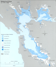
Prior to the introduction of European agricultural methods, the shores of San Francisco Bay consisted mostly of tidal marshes. Approximately 85% of those marshes have been lost or destroyed, but about 50 marshes and marsh fragments remain.
[2]
In the Delta area, marshes were drained for farmland. In San Francisco, marshes were filled in for urban development. In the East Bay, portions were used as landfill. In the South Bay, huge tracts have served as commercial
salt evaporation ponds
. In the North Bay, the
Napa Sonoma Marsh
and
Point Molate Marsh
remain productive ecosystems. Some wetlands have been restored or protected from further development. Success stories include
Eastshore State Park
and
Crissy Field
. Many native and recovered wetlands are preserved in the
Don Edwards San Francisco Bay National Wildlife Refuge
and the
San Pablo Bay National Wildlife Refuge
.
Wetlands also exist on the Pacific Coast (the
Estero Americano
, for instance) and in certain inland valleys: for example, the
Laguna de Santa Rosa
near
Santa Rosa
.
Transportation
[
edit
]
The Bay Area is a large natural harbor. Around it have grown seaports and naval facilities. Active ports include the ports of
Richmond
,
Redwood City
,
San Francisco
, and
Oakland
. Ships also traverse the bay heading to and from ports in
Stockton
and
Sacramento
. During
World War I
and
World War II
the region was the
United States
's major shipbuilding center for the Pacific. Former naval facilities include
Point Molate Naval Fuel Depot
,
Alameda Point Naval Facility
and
Mare Island Naval Shipyard
.
Many Bay Area cities have marinas, including
Berkeley
,
Petaluma
, and
Redwood City
.
There is also an extensive commuter ferry system, which is being expanded by the
San Francisco Bay Water Transit Authority
.
Oceanic harbors have been built at
Bodega Bay
and
Half Moon Bay
.
See also
[
edit
]
References
[
edit
]
|
|---|
| Outline
| | |
|---|
| Subdivisions
| |
|---|
| Waterways
| |
|---|
Parks and
protected areas
| |
|---|
Islands and
peninsulas
| |
|---|
| Wetlands
| |
|---|
Bridges
and tubes
| |
|---|
| Ferries
| |
|---|
Ports and
marinas
| |
|---|
| Other
| |
|---|
|
|
|---|
| Counties
| |
|---|
| Cities and towns
| |
|---|
| Islands
| |
|---|
| Waterways
| Rivers, creeks
and sloughs
| |
|---|
Man-made
channels
| |
|---|
|
|---|
| Other features
| |
|---|
Water supply
infrastructure
| |
|---|
| Designated areas
| |
|---|