Category 3 Atlantic hurricane in 1950
Hurricane Easy
 September 7, 1950, weather map featuring Hurricane Easy
|
|
| Formed
| September 1, 1950
|
|---|
| Dissipated
| September 9, 1950
|
|---|
|
| 1-minute sustained
(
SSHWS
/
NWS
)
|
| Highest winds
| 120 mph (195 km/h)
|
|---|
| Lowest pressure
| 958
mbar
(
hPa
); 28.29
inHg
|
|---|
|
| Fatalities
| 2 indirect
|
|---|
| Damage
| $3.3 million (1950
USD
)
|
|---|
| Areas affected
| Cuba
, Florida,
Georgia
|
|---|
IBTrACS
 |
Part of the
1950 Atlantic hurricane season
|
Hurricane Easy
was the fifth tropical storm, hurricane, and major hurricane of the
1950 Atlantic hurricane season
. The hurricane developed in the western Caribbean Sea on September 1, and tracked northeastward. After crossing
Cuba
, the hurricane rapidly strengthened in the eastern
Gulf of Mexico
to reach peak winds of 120 mph (200 km/h). Easy executed a cyclonic loop, moved northeastward to hit near
Cedar Key, Florida
, executed a second loop, and hit western Florida again. After rapidly weakening over Florida, the hurricane turned to the northwest, and ultimately dissipated over northeastern
Arkansas
on September 9. From the point when Hurricane Easy entered the Gulf of Mexico until it weakened to a tropical storm, it was observed nearly constantly from radars or
reconnaissance aircraft
.
Easy is the most recent major hurricane to strike the
Homosassa, Florida
, area.
[1]
Due to the hurricane remaining near the northwest Florida coast for an extended period of time, Easy produced severe rainfall and strong waves, resulting in heavy damage in the Cedar Key area. Hurricane Easy was one of two major hurricanes to strike Florida during the year; the other was
Hurricane King
which affected
Miami
.
Meteorological history
[
edit
]
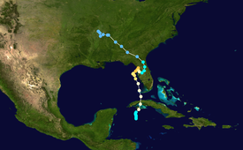 Map plotting the storm's track and intensity, according to the Saffir?Simpson scale
Map key
Tropical depression (≤38 mph, ≤62 km/h)
Tropical storm (39?73 mph, 63?118 km/h)
Category 1 (74?95 mph, 119?153 km/h)
Category 2 (96?110 mph, 154?177 km/h)
Category 3 (111?129 mph, 178?208 km/h)
Category 4 (130?156 mph, 209?251 km/h)
Category 5 (≥157 mph, ≥252 km/h)
Unknown
Following the passage of
Hurricane Baker
through the
Caribbean Sea
, a
trough
of
low pressure
persisted across the western
Caribbean Sea
. On August 31, convection became more concentrated to the south of the
Isle of Youth
, and on September 1 the disturbance developed into a tropical storm; it was later given the name "Easy", as part of the
United States Weather Bureau
naming
tropical cyclones with the
Joint Army/Navy Phonetic Alphabet
. A developing
anticyclone
and moist air over the region provided favorable conditions for intensification, as the storm tracked slowly northeastward. On September 2, Tropical Storm Easy attained hurricane status about 50 miles (85 km) south of the
Isle of Youth
.
[2]
After crossing the Isle of Youth, Hurricane Easy strengthened slightly while continuing northeastward, and the storm struck the
Matanzas Province
of
Cuba
with winds of 80 mph (130 km/h). The hurricane quickly crossed the island, passing just east of
Havana
before reaching the southeastern
Gulf of Mexico
on September 3. After entering the
Gulf of Mexico
, Easy turned to the north-northwest, paralleling the Florida coastline a short distance offshore while producing hurricane-force winds onshore. On September 4, the hurricane quickly strengthened to reach peak winds of 120 mph (190 km/h), an intensity it would retain for 18 hours. That day, a
ridge
of high pressure strengthened to the north of the storm, leaving weaker steering currents. This caused Hurricane Easy to execute a counter-clockwise loop to the west of
Tampa, Florida
.
[2]
After executing its first loop, Hurricane Easy moved northeastward at 7 mph (11 km/h) until making landfall near
Cedar Key
on September 5 with winds of 120 mph (190 km/h). Steering currents again became weak, causing Easy to execute a second loop in 24 hours towards the southeast. After briefly emerging into the Gulf of Mexico,
[2]
the hurricane made its final landfall on
Homosassa Springs
to the north of
Tampa
,
[3]
and rapidly weakened to a tropical storm over land. Easy turned to the northeast, which was followed by a turn to the northwest as the storm neared the
Atlantic
coast. On September 7, Easy crossed into
Georgia
, and shortly thereafter it weakened to a tropical depression. The depression continued northwestward for two days until dissipating over extreme northeastern
Arkansas
on September 9. The reason for its erratic track, including the two loops, is unknown, although it is potentially due to a
Fujiwhara interaction
with
Hurricane Dog
to its east.
[2]
Preparations and impact
[
edit
]
 Easy's Rainfall across the United States
The hurricane crossed over western
Cuba
with winds of up to 80 mph (130 km/h); however, damage was minor, and no deaths occurred in the country.
[4]
In
Havana
, winds decreased to 15 mph (24 km/h) as the eye of the hurricane crossed over the city.
[2]
With an
eye
ranging from 18 mi (29 km) to 25 mi (40 km) in diameter, the hurricane was well-tracked throughout its lifetime by radars at the
University of Florida
and by
Reconnaissance Aircraft
.
[2]
Despite its unusual track, the
Weather Bureau
issued
hurricane warnings
in a timely manner, though warnings were issued for a larger area than those that actually experienced hurricane-force winds.
[5]
In the
Florida Keys
, winds from Easy reached 72 mph (116 km/h), which downed trees and power lines, littering local streets with debris.
[6]
Heavy seas moved around a Navy barge, though no damage was reported.
[7]
Hurricane Easy produced hurricane-force winds across large portions of western Florida, including over 100 mph (160 km/h) winds in
Cedar Key
for 9 and 1/2 hours. The town, which reported a minimum pressure of 958.3
mbar
(28.30 in), experienced the eye of the hurricane for 2 and 1/2 hours
[5]
while strong waves hit the coast. The tide in
Tampa Bay
rose 6.5 ft (2.0 m), the highest since 1921.
[8]
While looping twice along its path, the hurricane dropped heavy amounts of rainfall of 10 in (250 mm) to 20 in (510 mm) in large portions of northwestern Florida. Rainfall totals include 24.5 in (620 mm) in Cedar Key in 3 days
[5]
and 38.70 in (983 mm) in
Yankeetown, Florida
, in 24 hours, which easily became the largest 24?hour rainfall total on record for the United States. The record has since been broken by
Tropical Storm Claudette
in 1979 with 43 in (1,100 mm), though Easy's total remains the largest 24?hour rainfall total on record for the state of Florida.
[9]
Hurricane Easy was described as the worst hurricane in the Cedar Key area in 70 years. The hurricane left half of the houses destroyed or unfit for rehabilitation, while 90% of the others were damaged.
[5]
The strong winds destroyed the roofs of 150 homes and buildings.
[3]
The rainfall caused severe flooding that resulted in crop damage. Easy was indirectly responsible for two deaths due to electrocutions. In addition, 27 people were injured from the hurricane.
[5]
The strong waves destroyed the fishing community's entire fishing fleet of 100 boats,
[3]
[8]
which was the town's entire livelihood.
[8]
The town's main employment center, a broom and brush plant, was severely damaged, and would close two years after the hurricane.
[3]
The hurricane also produced severe damage in
Pinellas
and
Hillsborough Counties
in the
Tampa
area.
[10]
Throughout Florida, damages totaled $3.3 million (1950 USD), a lower than expected total due to the sparse population in the area of the worst damage.
[5]
After the storm's passage throughout central and northern Florida, "blisters" developed on hundreds of cars; the locations affected reported that the blisters formed on the surface of vehicles shortly after Easy retreated. The following day, the blisters disappeared. Researchers later created several theories as to the unusual occurrence, though they concluded that air pockets under the layer of paint expanded as a result of the decreased barometric pressure.
[11]
Heavy rainfall from Hurricane Easy continued into Georgia and occurred throughout the state. The precipitation was most intense and destructive along Georgia's coast, damaging crops and vegetation after waterlogging fields. In some areas, 5?9 in (125?225 mm) of rain was recorded in a single day.
[12]
See also
[
edit
]
References
[
edit
]
- Barnes, Jay (2007).
Florida's Hurricane History
Chapel Hill Press.
ISBN
0-8078-2443-7
.
External links
[
edit
]
|
|---|
1851?1949
|
|---|
| 1850s
| |
|---|
| 1860s
| |
|---|
| 1870s
| |
|---|
| 1880s
| |
|---|
| 1890s
| |
|---|
| 1900s
| |
|---|
| 1910s
| |
|---|
| 1920s
| |
|---|
| 1930s
| |
|---|
| 1940s
| |
|---|
|
|
1950?present
|
|---|
| 1950s
| |
|---|
| 1960s
| |
|---|
| 1970s
| |
|---|
| 1980s
| |
|---|
| 1990s
| |
|---|
| 2000s
| |
|---|
| 2010s
| |
|---|
| 2020s
| |
|---|
|
|
|