History of Luton, in Bedfordshire, England
Luton
is a town located in the south of
Bedfordshire
,
England
.
Early history
[
edit
]
The earliest settlements in the
Luton
area were at
Round Green
and Mixes Hill, where
Paleolithic
encampments (about 250,000 years old) have been found.
[1]
: 20
Settlements reappeared after the ice had retreated in the
Mesolithic
around 8000 BC; settlements have been found in the
Leagrave
area. Remains from the
Neolithic
(4500?2500 BC in this area) are much more common. A particular concentration of Neolithic burials is at Galley Hill.
[1]
: 23
The most prominent Neolithic structure is
Waulud's Bank
, a
henge
dating from around 3000 BC. From the Neolithic onwards, the area seems to have been fairly thickly populated, but without any single large settlement.
The first urban settlement nearby was the small
Roman
town of
Durocobrivis
at
Dunstable
, but Roman remains in the modern area of Luton itself consist only of scattered farmsteads, with a core of settlement at Limbury with some evidence of substantial buildings, as well as at Wigmore and Park Street.
[1]
: 31
[2]
[3]
The foundation of Luton is usually dated to the 6th century when a
Saxon
outpost was founded on the
River Lea
,
Lea tun
.
[4]
Luton is recorded in the
Domesday Book
as
Loitone
and also as
Lintone
,
[5]
when the town's population was around 700?800. Agriculture dominated the local economy at this time.
 St Mary's Church
, Luton town centre
St Mary's Church
, Luton town centre
In 1121
Robert, 1st Earl of Gloucester
started work on
St Mary's Church
in the centre of the town, which was completed by 1137.
[6]
A
motte and bailey castle
which gives its name to 'Castle Street' was built in 1139 during
The Anarchy
.
The castle
was demolished in 1154.
[7]
The site is now home to
Matalan
. During the
Middle Ages
Luton is recorded as being home to six water mills. Mill Street, in the town centre, takes its name from one of them.
King John
(1166?1216) had hired a
mercenary
soldier,
Falkes de Breaute
, to act on his behalf. (
Breaute
is a small town near
Le Havre
in France.) When he married, he acquired his wife Margaret's London house which came to be known as "Fawkes Hall", subsequently corrupted over the years to "Foxhall", then "Vauxhall". In return for his services, King John granted Falkes the manor of Luton. He was also granted the right to bear his own
coat of arms
and chose the mythical
griffin
as his heraldic emblem. The griffin thus became associated with both
Vauxhall
and Luton in the early 13th century.
[8]
By 1240 the town is recorded as
Leueton
. The town had an annual market for surrounding villages in August each year, and with the growth of the town a second
fair
was granted each October from 1338.
In 1336, much of Luton was destroyed by a great fire, however the town was soon rebuilt.
The agriculture base of the town changed in the 16th century with a
brickmaking
industry developing around Luton, many of the older wooden houses were rebuilt in brick.
There were two skirmishes in Luton during the
English Civil War
. The first was in 1645, seeing
Parliamentarian soldiers
besetting a traveling group of
Cavalier soldiers
, killing four and capturing 22.
[9]
A second fight was spurred by an army of Calvaliers traveling through the town in 1648. Parliamentarian Roundheads encountered Royalist Cavaliers stragglers in a pub on the corner of Bridge Street. While most of the stragglers escaped, nine were killed.
[10]
It was in the 17th century when the
hatmaking
that became synonymous with the town began. By the 18th century the hatmaking industry, especially
straw hat
manufacture, dominated the town as its only significant industry. Hats are still produced in the town on a smaller scale.
The first
Luton Workhouse
was built in 1722. A larger workhouse was built in the town in 1836.
Luton Hoo
, a large country house to the south of the town, was built in 1767 on the site of an earlier manor house. Little of the 1767 house remains, as much of it was rebuilt after a fire in 1843. Luton Hoo was originally in the parish of Luton, but boundary changes in 1896 transferred it to the new parish of
Hyde
.
19th century
[
edit
]
 A map of Luton from 1888
The town grew strongly in the 19th century; in 1801 the population was 3,095.
[11]
By 1850 it was over 10,000 and by 1901 it was almost 39,000. The town was comparatively late to secure a railway connection. The
London and Birmingham Railway
(L&BR) had been built through
Tring
in 1838, and the
Great Northern Railway
was built through
Hitchin
in 1850, both missing Luton by several miles. A branch line connecting with the L&BR at
Leighton Buzzard
was proposed, but because of objections to release of land, the branch only reached Luton's neighbour, Dunstable, in 1848. It was another ten years before the branch was extended to
Bute Street Station
, and the first train from Luton to Dunstable ran on 3 May 1858.
[1]
: 141
The line was later extended to
Welwyn
as part of the
Hatfield, Luton and Dunstable branch line
of the Great Northern Railway, and from 1860 direct trains ran to
King's Cross
. The
Midland Railway
was extended from Bedford to
St Pancras
through
Leagrave
and
Midland Road station
and opened on 9 September 1867, giving the town a main line connection to London and the Midlands.
[1]
: 142
Luton had a gas supply in 1834, and the gas street lights were erected and the first
town hall
opened in 1847.
Newspaper printing arrived in the town in 1854, coincidentally the year the first public cemetery was opened. Following a cholera epidemic in 1848 Luton formed a water company and had a complete water and sewerage system by the late 1860s. The first covered market was built (the Plait Halls, now demolished) in 1869. Luton was made a borough in 1876
[12]
and the football club was founded in 1885 following the passing of a resolution at the Town Hall that the "Luton Town Club be formed".
[13]
20th century
[
edit
]
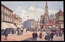
 George Street, looking North West towards the town hall in the early 20th Century
 George Street, looking South East towards market hill in the early 20th Century.
In the 20th century, the hat trade severely declined and was replaced by more modern industries. In 1905,
Vauxhall Motors
opened the largest car plant in the United Kingdom in Luton. In 1914
Hewlett & Blondeau
built an aircraft manufacturing plant in
Leagrave
which later became
Electrolux
in 1926, which set the precedent for further light manufacturing businesses in the town.
In 1904 councillors
Asher Hucklesby
and Edwin Oakley purchased the estate that became
Wardown Park
, and then donated the property to the people of Luton. Hucklesby went on to be Mayor of Luton. The main house became
Luton Museum
, whilst the grounds became one of the town's main public parks.
The town had a
tram system
from 1908 until 1932
[14]
and the first cinema was opened in 1909. A
Carnegie Library
opened in the town in 1910, built to the cost of £10,000 and the opening ceremony was attended by US Ambassador
Whitelaw Reid
and
Andrew Carnegie
himself.
[15]
[14]
By 1914, the population had reached 50,000.
The original
town hall
was destroyed in 1919 during the Peace Day celebrations at the end of the
First World War
; local people including many ex-servicemen were unhappy with unemployment and had been refused the use of a local park to hold celebratory events, and so stormed the town hall setting it on fire. (
See
Luton Town Hall
) A replacement town hall was completed in 1936.
Luton Airport
opened in 1938, owned and operated by the council.
In
World War II
, the Vauxhall Factory built
Churchill tanks
[16]
as part of the war effort and was heavily camouflaged. The Vauxhall factory made Luton a target for the
Luftwaffe
and the town suffered a number of
air raids
, in which 107 people died.
[17]
There was extensive physical damage to the town and over 1,500 homes were damaged or destroyed. Other industry in the town such as
SKF
(producing ball bearings), made a vital contribution to the war effort. Although a bomb landed at the SKF Factory
[18]
no major damage was inflicted.
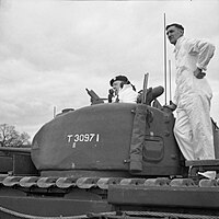 Winston Churchill in a Churchill tank during a visit to Luton
 Luton Town Centre
After World War II, there was a programme of
slum clearance
in the older inner suburbs of the town, whilst a number of substantial estates of council housing were built, notably at
Farley Hill
,
Stopsley
,
Limbury
,
Marsh Farm
,
Leagrave
, and (
Hockwell Ring
). The
M1
opened in 1959, skirting the western edge of the town. In 1962 a new library (to replace the Carneige Library) was opened by the Queen in the corner of St George's Square. In the late 1960s a large part of the town centre was cleared to build a covered shopping centre, the
Arndale Centre
, which was opened in 1972.
[19]
The Arndale Centre was renamed
The Mall Luton
in 2006.
In 1993 the town's higher education college became the
University of Luton
. Following mergers with other institutions, this became the
University of Bedfordshire
in 2006.
A new station was opened at
Luton Airport Parkway
in 1999.
In 2000, Vauxhall announced the end of car production in Luton; the plant closed in March 2002.
[20]
At its peak it had employed in excess of 30,000 people.
21st century
[
edit
]
The Mall was substantially extended and the adjoining St George's Square remodelled between 2007 and 2013.
[21]
The
Luton to Dunstable Busway
opened in 2013, re-using the route of the former Hatfield, Luton and Dunstable Railway.
On the edge of Luton, near to
Putteridge Bury
a new high-technology office park was built in the 2010s, called
Butterfield Green
. The former Vauxhall site is being re-developed as a mixed use site called
Napier Park
.
| Population since 1801
? Source: A Vision of Britain through Time
[22]
|
| Year
|
1801
|
1851
|
1901
|
1911
|
1921
|
1931
|
1941
|
1951
|
1961
|
1971
|
1981
|
1991
|
2001
|
2011
|
| Population Luton
|
2,985
|
11,067
|
31,981
|
49,315
|
57,378
|
66,762
|
84,516
|
106,999
|
132,017
|
162,928
|
163,208
|
174,567
|
184,390
|
203,201
|
Archaeological excavations
[
edit
]
An archaeological excavation was undertaken before the redevelopment of the Park Square campus,
University of Bedfordshire
.
[23]
Records
[24]
indicate that this area was the site of a castle built by
Fulk de Breaute
, an
Anglo-Norman
knight and favourite of
King John
,
[25]
some time between 1216 and 1221. One Medieval document shows that the castle was surrounded by a moat, as there was a complaint that de Breaute had dammed the nearby river (presumably to help keep water in the moat) and caused serious flooding to crops and buildings belonging to the church. De Breaute was one of the most powerful men in the kingdom at the time, so was not overly worried by the complaints and allegedly said that he wished that the damage had been worse.
Although called a castle, this building was probably more like a fortified
manor house
, surrounded by a
moat
and earthen bank. In the interior would have been living quarters, a
great hall
, stables and outbuildings. The line of the moat and bank was still visible in the 19th century and seems to have been rectangular in shape. Previous excavations revealed the line of the moat on the northwest side and found traces of timber buildings.
Underneath the demolished Student Union were the remains of 19th century buildings and below these, well preserved
medieval
features: ditches, postholes and large pits. Finds included clothes pins and pottery dating to the 12?13th centuries
[26]
confirming the activity was contemporary with
Falks de Breaute's
castle.
[27]
[28]
The majority of the pottery were
Hertfordshire
Greyware
which date to 12th ? early 13th centuries. Hertfordshire Greyware is the local pottery of the period, and there were at least two pottery kilns making this close to Luton; at
Hitchin
and to the east of
Toddington
.
Waulud's Bank
archaeological excavations in 1953, 1971 and 1982 date the site to around 3000 BC, in the
Neolithic
period, although there was evidence of earlier
mesolithic
hunting and fishing activity in the immediate area.
[29]
Administrative history
[
edit
]
The ancient
parish
of Luton was the largest in Bedfordshire, covering some 15,435 acres (62.5 km
2
). The parish
vestry
was the principal body of local government for the area from medieval times until the nineteenth century. The parish of Luton was part of
Flitt hundred
.
[30]
[31]
Under the
Poor Law Amendment Act 1834
a Luton
Poor Law Union
was established on 16 April 1835, covering the parish of Luton and a number of nearby parishes, mostly in southern Bedfordshire, but including parts of
Hertfordshire
. A large new workhouse was built on Dunstable Road, opening in 1836.
[32]
On 19 June 1850 a
Local Board of Health
was created for the town, being the town's first form of urban local government. The local board district only covered the township (effectively the built-up area of the town itself) and did not include the rest of the larger parish of Luton.
[33]
After elections, the board held its first meeting on 12 August 1850 at the Cock Inn, and John Waller was appointed the first chairman.
[34]
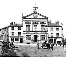 Luton Town Hall (1847?1919)
A Town Hall had been built in 1847 in a prominent position at the northern end of George Street, the town's main thoroughfare. It had been built by a private company but was later rented for meetings by the local board. The local board later purchased the building in 1874.
[35]
Under the
Public Health Acts
of 1872 and 1875, urban and rural
sanitary districts
were created. The Luton Local Board (based at the Town Hall) acted as the urban sanitary authority for the town itself, whilst the Luton Board of Guardians (based at the Workhouse) acted as the rural sanitary authority for the rest of the poor law union, including the rural parts of Luton parish outside the local board district.
On 25 February 1876 Luton became a
municipal borough
. The new borough's area was based on the local board district with minor adjustments, particularly along the southern boundary. The old local board's functions were taken over by the new borough council.
[36]
[37]
[38]
[39]
The new borough council held its first meeting at the Town Hall on 25 May 1876. The first mayor of the borough was William Bigg, a
Liberal
.
[40]
The previous year's chairman of the local board, George Charles Gostelow Lockhart, a
Conservative
, stood for election but initially failed to win a seat on the new council.
[41]
[42]
A coat of arms was granted to the new council on 25 July 1876.
[43]
Under the
Local Government Act 1894
, parish councils were created, taking over the remaining secular functions of the vestries. Parishes such as Luton which straddled a borough and a rural sanitary district were to be split, and parish councils only created for the area outside the borough. The parts of Luton parish outside the borough were initially placed in a parish called Luton Rural, which formed part of the similarly named but larger
Luton Rural District
. The parish of Luton Rural only existed for just over a year between December 1894 and March 1896, being split into four civil parishes called
Leagrave
,
Limbury
,
Stopsley
and
Hyde
on 1 April 1896.
[44]
[45]
After the Town Hall burned down in the Peace Day riots on 19 July 1919, the council used temporary premises in the town for the next seventeen years. The lecture theatre in the town's
Carnegie library
acted as the council chamber for much of this time.
[46]
[47]
A new
town hall
was eventually built on the site of the old building, opening in 1936.
[48]
In 1928 the parishes of Leagrave and Limbury were abolished, being absorbed back into Luton as part of the borough.
[49]
The parish of Stopsley followed suit in 1933.
[50]
Luton became a
County Borough
on 1 April 1964, operating all local government functions independently of
Bedfordshire County Council
, whilst remaining part of Bedfordshire for ceremonial purposes.
[51]
From 1 April 1974, under the
Local Government Act 1972
, Luton became a
non-metropolitan district
, with Bedfordshire County Council once more taking responsibility for some services in the town. In 1997
Luton Borough Council
was made a
unitary authority
, becoming once more independent of Bedfordshire County Council (which would later be abolished in 2009).
See also
[
edit
]
References
[
edit
]
- ^
a
b
c
d
e
Dyer, J; Stygall, F; Dony, J (1964).
The Story of Luton
. Luton.
{{
cite book
}}
: CS1 maint: location missing publisher (
link
)
- ^
Simco A, Survey of Bedfordshire:The Roman Period p.110
- ^
Hudspith R, Bedfordshire Archaeological Journal 23 pp88-89
- ^
Early history of Luton
- ^
Domesday book record
- ^
History of St Mary's Church
Archived
28 June 2008 at the
Wayback Machine
- ^
Luton Facts & Trivia
on Shout Luton! archived on the Wayback Machine
- ^
"Vauxhall history"
. Archived from
the original
on 8 July 2008
. Retrieved
22 March
2007
.
- ^
"A History of Luton"
.
Local Histories
. 14 March 2021
. Retrieved
29 April
2022
.
- ^
"Top 5 Historical Facts About Luton"
.
1ST Airport Taxis
. Retrieved
29 April
2022
.
- ^
Population figures for 1801, 1901 and 1901
- ^
Luton was made a borough
- ^
Formation of Luton Town
Archived
6 December 2008 at the
Wayback Machine
- ^
a
b
Allsopp, Anne (19 January 2018).
A History of Luton
. The History Press.
- ^
"The Carnegie Library Luton"
.
bedsarchives.bedford.gov.uk
. 21 June 2019
. Retrieved
17 April
2024
.
- ^
Churchill Tanks at Vauxhall
- ^
Deaths during WWII
- ^
See book
Luton at War volume II
,compiled by The Luton News, 2001,
ISBN
1-871199-49-2
- ^
tant-car-hire.co.uk/england/luton.html Arndale opened in 1972
Archived
19 August 2013 at the
Wayback Machine
- ^
Vauxhall closure
- ^
"Policy on St George's Square, 2013"
. Luton Borough Council
. Retrieved
28 August
2021
.
- ^
"Luton: Total Population"
.
A Vision of Britain Through Time
. Great Britain Historical GIS Project. Archived from
the original
on 14 August 2011
. Retrieved
16 June
2008
.
- ^
Marshall-Woodley, N & Abrams, J accepted 2012, Inside Fulk de Breaute’s 13th Century Castle, Bedfordshire Archaeology (formerly Bedfordshire Archaeological Journal)
- ^
Harward, C 2010, Land at Vicarage Street, Luton, Bedfordshire, Post-Excavation Assessment and Updated Project Design, ASE Report No.: 2010051 OASIS id: 76428
- ^
Dyer, J & Dony, JG. 1975 The Story of Luton. White Crescent Press Ltd, p 46
- ^
Franklin, J 2012, An Unusual Brooch Pin,
Institute for Archaeologists
Newsletter, Spring 2012
- ^
"Luton ? BedfordshireLive"
.
- ^
"Secrets from Luton's past unearthed at Bedfordshire ? beds.ac.uk"
. Archived from
the original
on 12 September 2013
. Retrieved
11 August
2012
.
- ^
"History of Luton"
.
Megalithic Portal
.
- ^
"Luton AP/CP"
.
A Vision of Britain through Time
. GB Historical GIS / University of Portsmouth
. Retrieved
28 August
2021
.
- ^
"Luton Administrative History"
. Bedfordshire Archives. 21 June 2019
. Retrieved
28 August
2021
.
- ^
Higginbotham, Peter (2021).
"Luton Poor Law Union"
.
The Workhouse
. Retrieved
28 August
2021
.
- ^
"No. 21106"
.
The London Gazette
. 21 June 1850. p. 1746.
- ^
"Luton: Public Health Act"
.
Bedford Times
. 17 August 1850. p. 3
. Retrieved
3 May
2024
.
- ^
"Luton Town Hall: The Old Building"
. Bedfordshire Archives. 21 June 2019
. Retrieved
28 August
2021
.
- ^
Somers Vine, J.R., ed. (1886).
The Municipal Corporations Companion
. London: Waterlow and Sons. p. 234
. Retrieved
28 August
2021
.
- ^
The Incorporation of Luton,
Bedfordshire and Hertfordshire News
(Luton), 4 March 1876, page 8
- ^
Luton Local Board of Health,
Luton Times
, 17 June 1876, page 6
- ^
Local Government Board Enquiry,
Luton Times
, 10 June 1876, page 5
- ^
The Death of Mr. W. Bigg,
Luton Reporter
, 9 March 1878, page 5
- ^
Board of Health,
Luton Times
, 24 Apr 1875, page 3
- ^
The Town Council,
Luton Times
, 27 May 1876, page 5
- ^
"Luton Borough Council"
.
Civic Heraldry
. Retrieved
28 August
2021
.
- ^
Luton Rural Parish Council,
Bedfordshire Advertiser
(Luton), 21 December 1894, page 7
- ^
Annual Report of the Local Government Board
. London: Her Majesty's Stationery Office. 1896. p. 370
. Retrieved
28 August
2021
.
The County of Bedford (Luton Rural) Confirmation Order, 1896
- ^
A Call for Service, Luton Reporter, 16 November 1920, page 4
- ^
A Record Inquest, Beds and Herts Pictorial (Luton), 12 December 1933, page 3
- ^
First Ceremony in New Council Chamber, Luton News and Bedfordshire Chronicle, 12 November 1936, page 12
- ^
Ministry of Health Provisional Order Confirmation (Luton Extension) Act, 1928
- ^
Ministry of Health Order No. 77050. The South Bedfordshire Review Order 1933.
- ^
"Luton MB/CB"
.
A Vision of Britain through Time
. GB Historical GIS / University of Portsmouth
. Retrieved
28 August
2021
.