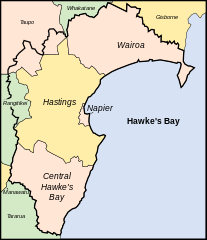
Region of New Zealand
Region in New Zealand
Hawke's Bay
(
M?ori
:
Te Matau-a-M?ui
[5]
) is a
region
on the east coast of
New Zealand
's
North Island
. The region is named for
Hawke Bay
, which was named in honour of
Edward Hawke
. The region's main centres are the cities of
Napier
and
Hastings
, while the more rural parts of the region are served by the towns of
Waipukurau
,
Waipawa
, and
Wairoa
.
Name
[
edit
]
 Hawke Bay
Hawke's Bay is named for the bay to its east,
Hawke Bay
, which was named in honour of
Edward Hawke, 1st Baron Hawke
by
Captain James Cook
during one of his voyages along the coasts of New Zealand.
The M?ori language name for Hawke's Bay is
Te Matau-a-M?ui
(
lit.
the fishhook belonging to
M?ui
). This name comes from a traditional story in which Maui lifted the islands of New Zealand from the waters. The story says that Hawke's Bay is the fishhook that M?ui used, with
Portland Island
and Cape Kidnappers being the northern and southern barbs of the hook, respectively.
[6]
Hawke's Bay is one of only two places in New Zealand with a possessive apostrophe in its name, the other being
Arthur's Pass
.
[7]
Captain Cook originally used an apostrophe in the name for the bay, but was inconsistent and wrote the name without an apostrophe a day later. Many New Zealanders spell the name without an apostrophe.
[8]
History
[
edit
]
 Maraetotara Falls
Early history
[
edit
]
Bay whaling stations operated on the shores of the bay in the nineteenth century.
[9]
Hawke's Bay Province
was founded in 1858 as a
province of New Zealand
, after being separated from the
Wellington Province
following a meeting in Napier in February 1858. The Province was abolished in 1876 along with all other provinces in New Zealand. It was replaced with a Provincial District.
1931 earthquake
[
edit
]
On February 3, 1931, Napier and Hastings were devastated by New Zealand's worst natural disaster,
an earthquake
measuring 7.9 on the
Richter magnitude scale
, which killed 256 people. Napier rebuilt and now the city is world-famous for its Art Deco buildings, and celebrates its heritage each February with the
Art Deco Weekend
.
MTG Hawke's Bay
, formerly Hawke's Bay Museum and Art Gallery, has an exhibition on the earthquake, its causes and impact.
Second World War
[
edit
]
During the
Second World War
, the
German submarine
U-862
entered the waters around Napier undetected, surfacing by the Sound Shell. The submarine fired a torpedo at the
Pukeko
, a steamer leaving the Port of Napier, but narrowly missed.
[10]
Cyclone Gabrielle
[
edit
]
On the 13th and 14 February 2023, Cyclone Gabrielle caused extensive damage in Hawke's Bay as it passed over the North Island. Power, phone service and internet access was cut to over 16,000 properties when the main Redcliffe substation was damaged in floodwaters after the
Tutaekuri River
burst its banks. Downstream, 1,000 people were evacuated from low-lying plains surrounding the river, where significant parts of Taradale, Meeanee and Awatoto were submerged.
The floodwaters destroyed 4 bridges, including Redcliffe Bridge, a major crossing just south of Taradale. SH2 and SH51 bridges were heavily damaged, but did not collapse. A span of the
Palmerston North-Gisborne Line
crossing the Tutaekuri River also collapsed. The
Ngaruroro River
also breached its banks, flooding the town of Omahu where 20 people required evacuation via helicopter.
In Wairoa, the
Wairoa River
breached its banks, flooding approximately 15 percent of the town. Access to Wairoa was cut off after extensive damage on SH2's Mohaka River Bridge in the south, and landslides also closing SH2 to the north. Water supply in Central Hawke's Bay failed, and a mandatory evacuation was ordered for eastern Waipawa after the Waipara river rose to record levels. The total cost and damages are unknown at this time.
[11]
[12]
Geography
[
edit
]
The region is situated on the east coast of the
North Island
. It bears the former name of what is now
Hawke Bay
, a large semi-circular bay that extends for 100 kilometres from northeast to southwest from
M?hia Peninsula
to
Cape Kidnappers
.
The Hawke's Bay Region includes the hilly coastal land around the northern and central bay, the floodplains of the
Wairoa River
in the north, the wide fertile
Heretaunga Plains
around
Hastings
in the south, and a hilly interior stretching up into the
Kaweka
and
Ruahine Ranges
. The prominent peak
Taraponui
is located inland.
Five major rivers flow to the Hawke's Bay coast. From north to south, they are the
Wairoa River
,
Mohaka River
,
Tutaekuri River
,
Ngaruroro River
and
Tukituki River
.
Lake Waikaremoana
, situated in northern Hawke's Bay, roughly 35 km from the coast, is the largest lake in Hawke's Bay, the fourth largest in the North Island and the 16th largest in New Zealand.
The region has a hill with the longest place name in New Zealand, and the longest in the world according to the 2009 Guinness Book of Records.
Taumatawhakatangihangakoauauotamateaturipukakapikimaungahoronukupokaiwhenuakitanatahu
is an otherwise unremarkable hill in southern Hawke's Bay, not far from
Waipukurau
.
[13]
Demographics
[
edit
]
Hawke's Bay Region covers 14,139.15 km
2
(5,459.16 sq mi)
[1]
and had an estimated population of 184,800 as of June 2023,
[2]
3.5 percent of New Zealand's population, with a population density of 13 people per km
2
. Around 74 percent of the region's population lives in the
Napier-Hastings conurbation
.
Ethnicities, 2023 Census
| Ethnicity
|
Population
|
| New Zealand European
|
|
| M?ori
|
|
| Pasifika
|
|
| Asian
|
|
| MELAA
|
|
| Other
|
|
Historical population
| Year
| Pop.
| ±% p.a.
|
|---|
| 1991
| 138,342
| ?
|
|---|
| 1996
| 142,791
| +0.64%
|
|---|
| 2001
| 142,950
| +0.02%
|
|---|
| 2006
| 147,783
| +0.67%
|
|---|
| 2013
| 151,179
| +0.33%
|
|---|
| 2018
| 166,368
| +1.93%
|
|---|
| 2023
| 175,074
| +1.03%
|
|---|
| Source:
[14]
[15]
|
Hawke's Bay Region had a population of 175,074 in the
2023 New Zealand census
, an increase of 8,706 people (5.2%) since the
2018 census
, and an increase of 23,895 people (15.8%) since the
2013 census
. There were 71,364 dwellings. The median age was 40.4 years (compared with 38.1 years nationally). There were 34,641 people (19.8%) aged under 15 years, 30,249 (17.3%) aged 15 to 29, 76,266 (43.6%) aged 30 to 64, and 33,915 (19.4%) aged 65 or older.
 Map of population density by Statistical Area 2 (2018 census estimates)
Hawke's Bay Region had a population of 166,368 at the
2018 New Zealand census
. There were 60,237 households. There were 81,054 males and 85,314 females, giving a sex ratio of 0.95 males per female.
Of those at least 15 years old, 21,417 (16.3%) people had a bachelor or higher degree, and 27,633 (21.0%) people had no formal qualifications. The median income was $28,300, compared with $31,800 nationally. 16,485 people (12.5%) earned over $70,000 compared to 17.2% nationally. The employment status of those at least 15 was that 63,999 (48.7%) people were employed full-time, 19,605 (14.9%) were part-time, and 4,710 (3.6%) were unemployed.
[16]
Below is a list of urban areas that contain more than 1,000 population.
Other towns and settlements in Hawke's Bay include:
Culture and identity
[
edit
]
| Largest groups of overseas-born residents
[17]
|
| Nationality
|
Population (2018)
|
| England
|
6,840
|
| Australia
|
2,625
|
| India
|
2,076
|
| Samoa
|
1,665
|
| South Africa
|
1,473
|
| Philippines
|
942
|
| Scotland
|
876
|
| China
|
765
|
| Netherlands
|
738
|
| United States
|
657
|
Ethnicities in the 2023 census were 73.3% European/
P?keh?
, 28.6%
M?ori
, 6.2%
Pasifika
, 6.5%
Asian
, 0.8% Middle Eastern, Latin American and African New Zealanders, and 1.2% other ethnicities. People may identify with more than one ethnicity.
[14]
The percentage of people born overseas was 15.9, compared with 27.1% nationally.
Although some people objected to giving their religion, 48.5% had no religion, 37.4% were Christian, 0.7% were Hindu, 0.4% were Muslim, 0.6% were Buddhist and 5.5% had other religions.
[16]
The major local M?ori tribe is
Ng?ti Kahungunu
.
Economy
[
edit
]
The subnational gross domestic product (GDP) of Hawke's Bay was estimated at NZ$8.67 billion in the year to March 2019, 2.9% of New Zealand's national GDP. The regional GDP per capita was estimated at $50,251 in the same period. In the year to March 2018, primary industries contributed $1.14 billion (13.9%) to the regional GDP, goods-producing industries contributed $1.84 billion (22.3%), service industries contributed $4.56 billion (55.3%), and taxes and duties contributed $707 million (8.6%).
[18]
Agriculture
[
edit
]
The region is renowned for its horticulture, with large orchards and vineyards on the plains. In the hilly parts of the region sheep and cattle farming predominates, with forestry blocks in the roughest areas.
Hawke's Bay has 17,886 ha (44,200 acres) of horticultural land, the third largest area in New Zealand behind
Canterbury
and
Marlborough
. The largest crops by land area are
apples
(4,750 ha), wine grapes (3,620 ha),
squash
(3,390 ha), and
peas
and
beans
(1,360 ha).
[19]
Wine
[
edit
]
 A Hawke's Bay vineyard in autumn
The climate is dry and temperate, and the long, hot summers and cool winters offer excellent weather for growing grapes. Missionaries in the mid 19th century planted the first vines in Hawke's Bay and it is now an important place for full bodied red wines.
[20]
The wine region is the second largest after the
Marlborough wine region
, with 4,681 hectares (11,570 acres) of vineyards and 91 operating wineries in 2018.
[21]
Aerospace
[
edit
]
Hawke's Bay is home to
Rocket Lab
's
Launch Complex 1
, New Zealand's first orbital launch site, on
M?hia Peninsula
.
Wairoa District
is home to
Space Coast New Zealand
, a stretch of coastline from which space launches can be viewed.
[22]
Rocket Lab launches its
Electron
rockets several times a year, after its first successful launch of
Humanity Star
in January 2018.
Infrastructure
[
edit
]
Air travel
[
edit
]
Hawke's Bay is served by
Hawke's Bay Airport
(also known as Napier Airport). 452,000 travellers passed through the terminal in the 12 months to June 2013. This increased to 652,426 in the 12 months to June 2017.
[23]
Hastings Aerodrome
is a smaller
uncontrolled airport
in
Bridge Pa
near Hastings.
Roads
[
edit
]
Inter-regional travel into and out of Hawke's Bay is served by
State Highway 2
and
State Highway 5
, as well as the
Taihape-Napier Road
.
State Highway 38
also connects inter-regionally, although it is less used due to being partially unsealed.
State Highway 2 enters the region coming south from Gisborne, connecting the East Cape region to Hawke's Bay. It continues through N?haka and then Wairoa, crossing over the Mohaka River near the
Mohaka Viaduct
. It then winds through the hills of northern Hawke's Bay, passing by
Lake T?tira
. It meets the ocean and then passes through Whirinaki where it intersects with the end of State Highway 5. After cutting by
Bay View
, it passes by Hawke's Bay Airport as it enters Napier next to
Pandora Pond
. As it goes through Napier it is concurrent with
State Highway 50
passing by Taradale. The
Hawke's Bay Expressway
forms the next section of the road as it crosses over the
Tutaekuri
and
Ngaruroro
rivers. The road then bisects Hastings and Flaxmere. The road continues through the
Heretaunga Plains
into Central Hawke's Bay, connecting the towns of ?t?ne, Waipawa, and Waipukurau. It then heads towards Takapau where it meets the other end of State Highway 50. After Takapau it heads into the Tararua District and through the towns of
Norsewood
and
Dannevirke
. State Highway 2 is the main route heading south from Napier-Hastings to get to major centres such as
Palmerston North
and
Wellington
.
State Highway 5 enters Hawke's Bay from the north-west as the Napier-Taupo Road. It serves as the main connection between Hawke's Bay and the main centres up north ? including Auckland, Hamilton, Tauranga, Rotorua, and Taup?. It travels through the hilly interior of the region. It meets up with State Highway 2 after passing through Eskdale.
The Taihape-Napier Road serves as an inland route between Hawke's Bay and the
Rangitikei
and
Ruapehu
districts, creating a connection to the towns of
Taihape
,
Waiouru
, and
Ohakune
.
State Highway 50 starts in
Ahuriri
in Napier and after being concurrent with State Highway 2, splits off and connects the more interior sections of the region ? including the settlements of
Fernhill
,
Maraekakaho
,
Tikokino
,
Ongaonga
, and
Ashley Clinton
. The road terminates at an intersection with State Highway 2 near Takapau.
Government
[
edit
]
Regional
[
edit
]
 Hawke's Bay Regional Council building in Napier
The region is governed by Hawke's Bay Regional Council, which has its main office and council chamber in Napier. The council consists of eleven elected members and holds elections every three years. As of 26 October 2022 the councillors are:
[24]
| Councillor
|
Constituency
|
| Hinewai Ormsby (chair)
|
Ahuriri/Napier general
|
| Will Foley (deputy chair)
|
Tamatea-Central Hawke's Bay general
|
| Xan Harding
|
Heretaunga-Hastings general
|
| Neil Kirton
|
Ahuriri/Napier general
|
| Charles Lambert
|
M?ui ki te Raki M?ori
|
| Jock Mackintosh
|
Heretaunga-Hastings general
|
| Di Roadley
|
Wairoa general
|
| Sophie Siers
|
Heretaunga-Hastings general
|
| Hokianga Thompson
|
M?ui ki te Tonga M?ori
|
| Jerf van Beek
|
Ngaruroro general
|
| Martin Williams
|
Ahuriri/Napier general
|
Proposal for a unitary authority
[
edit
]
Between 2013 and 2015 the
Local Government Commission
considered amalgamating Hawke's Bay Regional Council, its four constituent territorial authorities (
Napier City Council
,
Central Hawke's Bay District Council
,
Hastings District Council
and
Wairoa District Council
), and the small parts of the
Rangitikei District Council
(the rural community of
Ngamahanga
) and
Taupo District Council
(the rural community of
Taharua
) that fall within the Hawke's Bay Region into a unitary authority that would hold all local decision-making powers for the region. This proposal was initiated by an application from a group called "A Better Hawke's Bay"
[25]
and followed the
Government-led amalgamation of eight local authorities
into the new
Auckland Council
in 2010 and a 2012 "prosperity study" that found a similar amalgamation in Hawke's Bay could save up to $25m per year.
[26]
A previous proposal to merge Napier and Hastings, though supported by Hastings residents, was defeated in a public referendum in 1999.
[27]
The Local Government Commission released an initial proposal in November 2013.
[28]
After taking public submissions on the proposal, the Commission issued a final proposal in June 2015. The final proposal was that Hawke's Bay would be governed by a unitary council comprising a governing body (one mayor elected at-large and eighteen councillors elected across five wards) with subsidiary decision-making made by five local boards (each with six to nine elected members).
[29]
Under the
Local Government Act
, the public had the right to demand a binding referendum on whether the amalgamation should proceed; such a demand would be valid if it was signed by at least 10% of the affected electors in one of the affected districts. Two days after the final proposal was issued, a valid referendum demand signed by more than 10% of the affected electors in the Rangitikei district was received
[30]
(there were only twelve affected electors in that district, therefore only two signatures were required to trigger the poll
[27]
[31]
). The referendum was held by post. Voting concluded on Tuesday 15 September 2015. Because 66% of electors opposed the change,
[32]
the proposal was defeated and did not progress further. Results broken down to the council level showed that only Hastings district electors favoured amalgamation (52% in favour). Napier (84% opposed), Wairoa District (88% opposed) and Central Hawke's Bay (58%) were opposed. Only four votes were returned from Rangitikei (two each way); no votes were returned from Taupo district.
[32]
Sub-regional
[
edit
]
 Territorial Authorities map of Hawkes Bay
Government at the level below regional is organised into
territorial authorities
, consisting of
Hastings District
,
Wairoa District
,
Central Hawke's Bay District
, and
Napier City
. The localities of Taharua in the
Taupo District
and
Ngamatea
in the
Rangitikei District
are also within the boundaries of the region. It does not include the
Tararua District
,
Dannevirke
,
Woodville
or
Norsewood
, which have been under the
Manawat?-Whanganui Regional Council
(also known as Horizons Regional Council) since the
1989 local government reforms
.
[33]
[34]
| District
|
Mayor
|
Year Elected
|
| Central Hawke's Bay
|
Alex Walker
|
2016
|
| Hastings
|
Sandra Hazlehurst
|
2017
|
| Napier
|
Kirsten Wise
|
2019
|
| Wairoa
|
Craig Little
|
2013
|
National
[
edit
]
 General electorate map of Hawke's Bay
Hawke's Bay is covered by five
general electorates
? namely
Napier
,
Tukituki
,
Wairarapa
,
Rangit?kei
, and
Taup?
.
[35]
The bulk of the region is contained within the Napier and Tukituki electorates, the former comprising most of the northern part of the region (including Napier and Wairoa), whilst the latter comprises much of the central parts of the region and the area around Hastings, including Havelock North and Clive. Wairarapa, which extends across parts of
Greater Wellington
and Manawat?-Whanganui, includes much of Central Hawke's Bay District, including Waipukurau and Waipawa. The Rangit?kei and Taup? electorates do not contain much of any population within the region.
Napier and Tukituki are often called '
bellwether
' electorates.
[36]
[37]
Since the introduction of
Mixed-Member Proportional
elections in New Zealand, both electorates have been held by both
Labour
and
National
members of parliament, often shifting in a way similar to that of the nation as a whole.
Hawke's Bay is also covered by three
M?ori electorates
? namely
Ikaroa-R?whiti
,
Waiariki
, and
Te Tai Hau?uru
.
[38]
The vast majority of the population of the region is within the Ikaroa-R?whiti electorate.
-
Catherine Wedd
-
Katie Nimon
-
Mike Butterick
-
Cushla Tangaere-Manuel
Culture and lifestyle
[
edit
]
Hawke's Bay Anniversary Day
[
edit
]
Hawke's Bay Anniversary Day is an annual day of celebration held on the Friday before Labour Day. It is celebrated throughout the old provincial boundaries of Hawke's Bay.
 Inside a Hawke's Bay winery
Media
[
edit
]
The region is served by a variety of radio stations including Radio Kahungunu, The Hits 89.5, More FM, access station Radio Hawke's Bay (formally Radio Kidnappers) and local station Bay FM. As well, most of the national commercial and non-commercial operators have transmitters covering the region.
 Himalayan cedar in Cornwall Park
 Cape Kidnappers
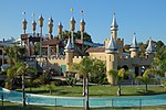 Splash Planet
Parks and nature
[
edit
]
Hawke's Bay is home to numerous parks, forests, beaches and various other natural attractions.
Napier and Hastings are home to many parks, with major parks including Cornwall, Frimley, and Windsor Parks in Hastings, and Anderson Park, Park Island, Taradale Park and the Botanical Gardens in Napier.
Located in Windsor Park is
Splash Planet
, an
amusement
and
water park
that is open in the summer.
Cape Kidnappers
, a headland at the south-eastern extremity of Hawke Bay, is a popular tourist attraction. The cape has been identified as an
Important Bird Area
due to being a breeding site for over 6500 pairs of
Australasian gannets
.
Food
[
edit
]
The
Hawke's Bay wine region
produces some of New Zealand's finest wines, celebrated together with local cuisine twice a year with the
Food And Wine Classic
festivals. These take place over several weekends in winter and ten days in summer, attracting thousands of visitors, many from overseas.
[39]
Music
[
edit
]
Napier is home to the Mission Concert held early each year since 1993. The event, held at the
Mission Estate Winery
in
Taradale
, has attracted performers such as
Kenny Rogers
,
Elton John
,
Shirley Bassey
,
Rod Stewart
,
The B-52's
,
Belinda Carlisle
,
Ray Charles
, and
Eric Clapton
. The 2009 concert attraction was to be
Lionel Richie
, but the concert was cancelled because of rain.
UK music artist Tycho Jones was staying in Hastings, Hawkes Bay when he was inspired to write the track Don't Be Afraid, produced by
Jonathan Quarmby
.
[40]
Sport
[
edit
]
The
Hawke's Bay Rugby Union
's representative team, the Magpies, plays in New Zealand's annual professional domestic
rugby union
competition, the
Mitre 10 Cup
. The team represents the Hawke's Bay Region in provincial representative rugby, and draws its players from the constituent clubs who are affiliated to the provincial union. The team play their home matches in
McLean Park
in Napier. Players representing Hawke's Bay are also eligible to play for the
Hurricanes
in the annual transnational
Super Rugby competition
. Hawke's Bay has produced
a number of All Blacks
.
The
Hawke's Bay Hawks
compete in the
New Zealand National Basketball League
.
Seismicity
[
edit
]
Hawke's Bay is one of the most seismically active regions in New Zealand and has experienced many large and often damaging earthquakes. More than 50 damaging earthquakes have been recorded in the region since the 1800s.
| Date
|
Location
|
Magnitude (ML)
|
Depth
|
Fatalities
|
More information
|
| 8 Jul 1843
|
25 km west of Tikokino
|
7.6
|
12 km
|
2
|
[41]
|
| 22 Feb 1863
|
Waipukurau
|
7.5
|
25 km
|
|
1863 Hawke's Bay earthquake
[42]
|
| 14 Sep 1875
|
M?hia Peninsula
|
5.8
|
25 km
|
|
[43]
|
| 9 Aug 1904
|
Porangahau
|
7.0
|
16 km
|
|
[44]
|
| 28 Jun 1921
|
Kaweka Forest Park
|
6.7
|
80 km
|
|
[45]
|
| 12 Feb 1930
|
Porangahau
|
6.2
|
33 km
|
|
[46]
|
| 3 Feb 1931
|
20 km north of Napier
|
7.8
|
20 km
|
256
|
1931 Hawke's Bay earthquake
[47]
|
| 3 Feb 1931
|
25 km north east of Napier
|
5.8
|
25 km
|
|
[48]
|
| 8 Feb 1931
|
Wairoa
|
6.4
|
60 km
|
|
[49]
|
| 13 Feb 1931
|
50 km east of Napier
|
7.3
|
30 km
|
|
[50]
|
| 5 May 1932
|
50 km east of Napier
|
5.9
|
12 km
|
|
[51]
|
| 16 Sep 1932
|
Wairoa
|
6.9
|
12 km
|
|
[52]
|
| 5 Mar 1934
|
Pongaroa
|
7.2
|
12 km
|
|
[53]
|
| 15 Mar 1934
|
Wairoa
|
6.3
|
25 km
|
|
[54]
|
| 26 Feb 1940
|
Hastings
|
6.0
|
25 km
|
|
[55]
|
| 1 Mar 1950
|
Lake Waikaremoana
|
5.8
|
60 km
|
|
[56]
|
| 10 Feb 1951
|
Porangahau
|
6.2
|
33 km
|
|
[57]
|
| 6 Oct 1980
|
Hastings
|
5.7
|
30 km
|
|
[58]
|
| 19 Feb 1990
|
Porangahau
|
6.2
|
34 km
|
|
[59]
|
| 13 May 1990
|
Porangahau
|
6.4
|
30 km
|
|
[60]
|
References
[
edit
]
- ^
a
b
"ArcGIS Web Application"
.
statsnz.maps.arcgis.com
. Retrieved
26 February
2022
.
- ^
a
b
c
"Subnational population estimates (RC, SA2), by age and sex, at 30 June 1996-2023 (2023 boundaries)"
.
Statistics New Zealand
. Retrieved
25 October
2023
.
(regional councils);
"Subnational population estimates (TA, SA2), by age and sex, at 30 June 1996-2023 (2023 boundaries)"
.
Statistics New Zealand
. Retrieved
25 October
2023
.
(territorial authorities);
"Subnational population estimates (urban rural), by age and sex, at 30 June 1996-2023 (2023 boundaries)"
.
Statistics New Zealand
. Retrieved
25 October
2023
.
(urban areas)
- ^
"Sub-national HDI - Area Database - Global Data Lab"
.
hdi.globaldatalab.org
. Retrieved
18 February
2023
.
- ^
"Regional gross domestic product: Year ended March 2022"
.
www.stats.govt.nz/
. Retrieved
30 October
2023
.
- ^
Pollock, Kerryn. '
Hawke’s Bay region - Overview
'.
Te Ara - the Encyclopedia of New Zealand
. (accessed 9 November 2017)
- ^
"Te Matau-a-M?ui: The hook of M?ui | Hawke's Bay NZ"
.
www.hawkesbaynz.com
. Retrieved
30 October
2023
.
- ^
Fowler, Michael (26 October 2019).
"Hawke's Bay named after Cook's boss"
.
The New Zealand Herald
. Retrieved
29 January
2024
.
- ^
Pollock, Kerryn.
"Hawke's Bay region"
.
Te Ara: The Encyclopedia of New Zealand
. Retrieved
29 January
2024
.
- ^
Don Grady (1986)
Sealers & whalers in New Zealand waters
, Auckland, Reed Methuen, p.150.
ISBN
0474000508
- ^
Hunt, Megan (28 September 2016).
"Memorial unveiled to mark German submarine's Napier visit"
.
Stuff
. Retrieved
31 October
2023
.
- ^
"Cyclone Gabrielle: Town cut off as Wairoa River bursts its banks, flooding homes of about half its population"
. 14 February 2023.
- ^
"Hawke's Bay RSE workers rescued after 10 hours trapped on roofs amid flood waters"
. 4 January 2024.
- ^
"Town with the longest name in New Zealand"
.
www.newzealand.com
. Retrieved
27 November
2023
.
- ^
a
b
"2023 Census national and subnational usually resident population counts and dwelling counts"
(Microsoft Excel)
. Stats NZ - Tatauranga Aotearoa
. Retrieved
29 May
2024
.
- ^
"2001 Census: Regional summary"
.
archive.stats.govt.nz
. Retrieved
28 April
2020
.
- ^
a
b
"Statistical area 1 dataset for 2018 Census"
. Statistics New Zealand. March 2020. Hawke's Bay Region (06).
2018 Census place summary: Hawke's Bay Region
- ^
"Birthplace (detailed), for the census usually resident population count, 2006, 2013, and 2018 Censuses (RC, TA, SA2, DHB)"
. Statistics New Zealand.
- ^
"Regional gross domestic product: Year ended March 2019 | Stats NZ"
.
www.stats.govt.nz
. Retrieved
21 May
2020
.
- ^
"Fresh Facts: New Zealand Horticulture"
(PDF)
.
Plant & Food Research
. 2018.
ISSN
1177-2190
.
- ^
The-Wine-Library
Archived
5 October 2011 at the
Wayback Machine
Short Description of wine in Hawkes Bay
- ^
"New Zealand Winegrowers Annual Report 2018"
(PDF)
.
New Zealand Winegrowers
. 2018
. Retrieved
5 August
2019
.
- ^
"Space Coast New Zealand"
. Wairoa District Council
. Retrieved
8 August
2019
.
- ^
"Record Number of Passengers through Hawke's Bay Airport | Hawke's Bay Airport"
.
www.hawkesbay-airport.co.nz
. Retrieved
31 October
2023
.
- ^
"Hawke's Bay council elects youngest and first wahine chair"
.
Inside Government NZ
. JSL Media. 26 October 2022
. Retrieved
26 October
2022
.
- ^
"Decisions and Determinations | Local Government Commission"
.
www.lgc.govt.nz
. Retrieved
27 April
2021
.
- ^
"Hawke's Bay amalgamation could save $25m"
.
Stuff
. 3 September 2012.
Archived
from the original on 27 April 2021
. Retrieved
27 April
2021
.
- ^
a
b
Laing, Doug.
"Close to quarter on roll cast votes"
.
New Zealand Herald
.
Archived
from the original on 27 April 2021
. Retrieved
27 April
2021
.
- ^
Henderey, Simon (26 November 2013).
"Amalgamation plan revealed"
.
New Zealand Herald
.
Archived
from the original on 27 April 2021
. Retrieved
27 April
2021
.
- ^
Local Government Commission (June 2015).
"Hawke's Bay Local Government Reorganisation: Final Proposal"
(PDF)
.
Archived
(PDF)
from the original on 29 January 2021
. Retrieved
27 April
2021
.
- ^
"Poll process update for Hawke's Bay reorganisation proposal | Local Government Commission"
.
www.lgc.govt.nz
. Retrieved
27 April
2021
.
- ^
Sharpe, Marty (27 November 2013).
"Two people could force council amalgamation poll"
.
Stuff
.
Archived
from the original on 3 December 2013
. Retrieved
27 April
2021
.
- ^
a
b
electionz.com (18 September 2015).
"Hawke's Bay Reorganisation Poll"
.
www.scoop.co.nz
.
Archived
from the original on 30 October 2020
. Retrieved
27 April
2021
.
Four votes from Rangitikei were received in the referendum, with turnout from that being 33.33% showing that the total number of affected electors was approximately 12.
- ^
Pollock, Kerryn (15 November 2012).
"Hawke's Bay region ? Local government boundary changes"
.
Te Ara ? the Encyclopedia of New Zealand
.
- ^
Pollock, Kerryn (15 November 2012).
"Hawke's Bay region ? Government, education and health"
.
Te Ara ? the Encyclopedia of New Zealand
.
- ^
"Stats NZ Geographic Data Service"
.
datafinder.stats.govt.nz
. Retrieved
28 October
2023
.
- ^
"Hawke's Bay Today to host three election candidate evenings as campaign heats up"
.
NZ Herald
. 28 October 2023
. Retrieved
28 October
2023
.
- ^
Sharpe, Marty (22 August 2023).
"National leads polling in bellwether Napier, but 23 per cent of voters undecided"
.
Stuff
. Retrieved
28 October
2023
.
- ^
"Stats NZ Geographic Data Service"
.
datafinder.stats.govt.nz
. Retrieved
28 October
2023
.
- ^
Harfield, Ruby (13 November 2017).
"Newcomers flock to 10-day Hawke's Bay Food and Wine Classic F.A.W.C!"
.
Hawke's Bay Today
. Retrieved
8 August
2019
.
- ^
Sawyer, Jack (9 May 2020).
"Tycho Jones delivers on single-run finale with 'Don't Be Afraid' & Tychonaut EP"
.
Musical Motif
.
- ^
"A magnitude 7.6 earthquake occurred 35 km east of Taihape, New Zealand on Sat Jul 8 1843 5:09 PM. The quake was 12 kilometres deep and the shaking was severe close to the quake"
.
- ^
"A magnitude 7.5 earthquake occurred Within 5 km of Waipukurau, New Zealand on Mon Feb 23 1863 12:39 AM. The quake was 25 kilometres deep and the shaking was severe close to the quake"
.
- ^
"A magnitude 5.8 earthquake occurred 35 km south of Gisborne, New Zealand on Tue Sep 14 1875 11:39 PM. The quake was 25 kilometres deep and the shaking was strong close to the quake"
.
- ^
"A magnitude 7.0 earthquake occurred 20 km south-west of Porangahau, New Zealand on Tue Aug 9 1904 10:20 AM. The quake was 16 kilometres deep and the shaking was severe close to the quake"
.
- ^
"A magnitude 6.7 earthquake occurred 45 km north-west of Napier, New Zealand on Wed Jun 29 1921 1:28 AM. The quake was 80 kilometres deep and the shaking was severe close to the quake"
.
- ^
"A magnitude 6.2 earthquake occurred 10 km south-west of Porangahau, New Zealand on Wed Feb 12 1930 6:22 PM. The quake was 33 kilometres deep and the shaking was severe close to the quake"
.
- ^
"GeoNet News"
.
info.geonet.org.nz
.
- ^
"A magnitude 5.8 earthquake occurred 20 km north of Napier, New Zealand on Tue Feb 3 1931 8:41 PM. The quake was 25 kilometres deep and the shaking was strong close to the quake"
.
- ^
"A magnitude 6.4 earthquake occurred 15 km south-east of Wairoa, New Zealand on Sun Feb 8 1931 1:44 PM. The quake was 60 kilometres deep and the shaking was severe close to the quake"
.
- ^
"A magnitude 7.3 earthquake occurred 50 km south of Wairoa, New Zealand on Fri Feb 13 1931 1:27 PM. The quake was 30 kilometres deep and the shaking was severe close to the quake"
.
- ^
"A magnitude 5.9 earthquake occurred 45 km east of Napier, New Zealand on Thu May 5 1932 7:54 PM. The quake was 12 kilometres deep and the shaking was strong close to the quake"
.
- ^
"A magnitude 6.9 earthquake occurred 15 km north-east of Wairoa, New Zealand on Fri Sep 16 1932 1:25 AM. The quake was 12 kilometres deep and the shaking was severe close to the quake"
.
- ^
"A magnitude 7.2 earthquake occurred 5 km east of Pongaroa, New Zealand on Mon Mar 5 1934 11:46 PM. The quake was 12 kilometres deep and the shaking was severe close to the quake"
.
- ^
"A magnitude 6.3 earthquake occurred 30 km south-west of Wairoa, New Zealand on Thu Mar 15 1934 10:46 PM. The quake was 25 kilometres deep and the shaking was severe close to the quake"
.
- ^
"A magnitude 6.0 earthquake occurred 30 km north-west of Hastings, New Zealand on Mon Feb 26 1940 6:16 PM. The quake was 25 kilometres deep and the shaking was strong close to the quake"
.
- ^
"A magnitude 5.8 earthquake occurred 45 km north-west of Wairoa, New Zealand on Wed Mar 1 1950 6:58 AM. The quake was 60 kilometres deep and the shaking was moderate close to the quake"
.
- ^
"A magnitude 6.2 earthquake occurred 35 km east of Porangahau, New Zealand on Sat Feb 10 1951 3:27 PM. The quake was 33 kilometres deep and the shaking was strong close to the quake"
.
- ^
"A magnitude 5.7 earthquake occurred 5 km south of Hastings, New Zealand on Mon Oct 6 1980 3:32 AM. The quake was 30 kilometres deep and the shaking was strong close to the quake"
.
- ^
"A magnitude 6.2 earthquake occurred 20 km north-east of Pongaroa, New Zealand on Mon Feb 19 1990 6:34 PM The quake was 34 kilometres deep and the shaking was severe close to the quake"
.
- ^
"A magnitude 6.4 earthquake occurred 15 km south-west of Porangahau, New Zealand on Sun May 13 1990 4:23 PM. The quake was 30 kilometres deep and the shaking was severe close to the quake"
.
External links
[
edit
]