County in Hawaii, United States
County in Hawaii
Hawaii County
(
Hawaiian
:
Kalana o Hawai?i
) (officially known as the
County of Hawai?i
) is a
county
in the
U.S. state
of Hawaii in the
Hawaiian Islands
. It is coextensive with the
Island of Hawaii
, often called the "Big Island" to distinguish it from the state as a whole. The
2020 Census
population was 200,629.
[1]
The
county seat
is
Hilo
. There are no
incorporated cities
in Hawaii County (see
Hawaii Counties
). The Hilo
Micropolitan Statistical Area
includes all of Hawaii County. Hawaii County has a
mayor?council
form of government. In terms of geography, Hawaii County is the most expansive county in the state and the most southerly county in the United States.
The
mayor of Hawaii County
is Mitch Roth, who took office in 2020. Legislative authority is vested in a nine-member Hawaii County Council.
Hawaii County is one of seven counties in the United States to share the same name as the state they are in (the other six are
Arkansas County
,
Idaho County
,
Iowa County
,
New York County
,
Oklahoma County
, and
Utah County
).
[2]
Geography
[
edit
]
Hawaii County has a total area of 5,086.70 square miles (13,174.5 km
2
); 4,028.02 square miles (10,432.5 km
2
) is land and 1,058.69 square miles (2,742.0 km
2
) is water
[3]
(mostly all off the ocean shoreline but counted in the total area by the U.S. Census Bureau). The county's land area comprises 62.7 percent of the state's land area. It is the highest percentage by any county in the United States. (Delaware's
Sussex County
comes in second at 48.0 percent, while Rhode Island's
Providence County
is third at 39.55 percent.)
Major highways
[
edit
]
Adjacent county
[
edit
]
Demographics
[
edit
]
Historical population
| Census
| Pop.
| Note
| %±
|
|---|
| 1900
| 46,843
| | ?
|
|---|
| 1910
| 55,382
| | 18.2%
|
|---|
| 1920
| 64,895
| | 17.2%
|
|---|
| 1930
| 73,325
| | 13.0%
|
|---|
| 1940
| 73,276
| | ?0.1%
|
|---|
| 1950
| 68,350
| | ?6.7%
|
|---|
| 1960
| 61,332
| | ?10.3%
|
|---|
| 1970
| 63,468
| | 3.5%
|
|---|
| 1980
| 92,053
| | 45.0%
|
|---|
| 1990
| 120,317
| | 30.7%
|
|---|
| 2000
| 148,677
| | 23.6%
|
|---|
| 2010
| 185,079
| | 24.5%
|
|---|
| 2020
| 200,629
| | 8.4%
|
|---|
| 2023 (est.)
| 207,615
| [4]
| 3.5%
|
|---|
As of 2010
[update]
, the island had a resident population of 185,079.
[5]
There were 64,382 households in the county. The
population density
was 17.7/km
2
(46/sq mi). There were 82,324 housing units at an average density of 8/km
2
(21/sq mi). The racial makeup of the county was 34.5%
White
, 29.2% from two or more races, 22.6%
Asian
, 12.4%
Native Hawaiian
or other
Pacific Islander
and 0.7%
African American
; 11.8% of the population were
Hispanics or Latinos
of any race. The largest ancestry groups were:
- 9.8% Japanese
- 9.6% German
- 8.6% Filipino
- 8.5% Native Hawaiian
- 8.3% Portuguese
- 6.9% Irish
- 5.7% English
- 5.1% Puerto Rican
- 3.2% Mexican
- 2.5% French
- 2.2% Italian
- 1.9% Spanish
- 1.7% Scottish
- 1.5% Scotch-Irish
- 1.5% Swedish
- 1.1% Polish
- 1.1% Dutch
- 1.0% Norwegian
There were 64,382 households, out of which 32.2% had children under the age of 18 living with them, 50.6% were
married couples
living together, 13.2% had a woman whose husband did not live with her, and 30.4% were non-families. 23.1% of all households were made up of individuals, and 8.0% had someone living alone who was 65 years of age or older. The average household size was 2.75 and the average family size was 3.24.
The age distribution was 26.1% under 18, 8.2% from 18 to 24, 26.2% from 25 to 44, 26.0% from 45 to 64, and 13.5% who were 65 or older. The median age was 39 years. For every 100 females, there were 100 males. For every 100 females age 18 and over, there were 98 males.
41.3% of the people on Hawaii island are religious, meaning they affiliate with a religion. 18.4% are Catholic; 3.7% are of another Christian faith; 5.1% are LDS; 5.0% are of an Eastern faith; 0.1% are Muslim.
[
citation needed
]
Government and infrastructure
[
edit
]
County government
[
edit
]
| This article's
factual accuracy
may be compromised due to out-of-date information
. The reason given is: Redistricted 2011 and expected to redistrict again late 2021.
Please help update this article to reflect recent events or newly available information.
(
September 2021
)
|
Executive authority is vested in the
mayor of Hawaii County
, who is elected for a four-year term. Since 2004, the election by the voters has been on a nonpartisan basis. In 2020, Mitch Roth was elected mayor, succeeding
Harry Kim
, who lost reelection after being defeated in the primary election.
[6]
Legislative authority is vested in a nine-member County Council. Members of the County Council are elected on a nonpartisan basis to two-year terms from single-member districts.
[7]
As of December 2016, Hawaii County Council has a female supermajority for the first time, with six women and three men.
[8]
Administrative districts were originally based on the traditional land divisions called
Moku
of
Ancient Hawaii
. Some more heavily populated districts have since been split into North and South districts to make them more comparable on a population basis.
The number following each district is the Tax Map Key (TMK) number, used to locate state property information. They are assigned in a counter-clockwise order beginning on the eastern side of the island.
[9]
| Nr.
|
District
|
Area
mi
2
|
Population
2000
|
moku
|
Map
|
| 1
|
Puna
|
499.45
|
31,335
|
Puna
|
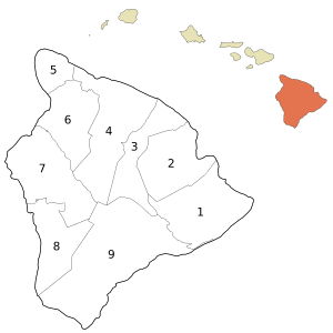
|
| 2
|
South Hilo
|
394.38
|
47,386
|
Hilo
|
| 3
|
North Hilo
|
370.65
|
1,720
|
Hilo
|
| 4
|
H?m?kua
|
580.50
|
6,108
|
H?m?kua
|
| 5
|
North Kohala
|
132.92
|
6,038
|
Kohala
|
| 6
|
South Kohala
|
351.72
|
13,131
|
Kohala
|
| 7
|
North Kona
|
489.01
|
28,543
|
Kona
|
| 8
|
South Kona
|
335.38
|
8,589
|
Kona
|
| 9
|
Ka??
|
922.22
|
5,827
|
Ka??
|
|
|
Hawai?i County
|
4028.02
|
148,677
|
6
moku
|
County council districts do not directly match the property tax districts because of the variation in the population density of voters in urban areas to rural areas; Hilo & Kailua (Kailua-Kona) towns are densely populated areas, while other districts such as Ka??, Puna, H?m?kua, and North & South Kohala are more sparsely populated.
[10]
Several government functions are administered at the county level that are at the state or municipal level in other states. For example, the county has its own office of liquor control.
[11]
State government
[
edit
]
Hawaii Department of Public Safety
previously operated the
Kulani Correctional Facility
in Hawaii County, on the
Island of Hawaii
.
[12]
In 2009, the Hawaii Department of Public Safety announced that Kulani Correctional Facility would close.
[13]
Presidential election results
[
edit
]
United States presidential election results for Hawaii County, Hawaii
[14]
| Year
|
Republican
|
Democratic
|
Third party
|
| No.
|
%
|
No.
|
%
|
No.
|
%
|
| 2020
|
26,897
|
30.63%
|
58,731
|
66.88%
|
2,186
|
2.49%
|
| 2016
|
17,501
|
26.98%
|
41,259
|
63.61%
|
6,107
|
9.41%
|
| 2012
|
14,753
|
23.25%
|
47,224
|
74.42%
|
1,477
|
2.33%
|
| 2008
|
14,866
|
22.22%
|
50,819
|
75.94%
|
1,231
|
1.84%
|
| 2004
|
22,032
|
38.18%
|
35,116
|
60.86%
|
554
|
0.96%
|
| 2000
|
17,050
|
33.52%
|
28,670
|
56.37%
|
5,140
|
10.11%
|
| 1996
|
13,516
|
27.60%
|
27,262
|
55.66%
|
8,199
|
16.74%
|
| 1992
|
15,460
|
30.36%
|
25,725
|
50.52%
|
9,731
|
19.11%
|
| 1988
|
17,125
|
41.00%
|
24,091
|
57.68%
|
552
|
1.32%
|
| 1984
|
20,707
|
52.90%
|
17,866
|
45.64%
|
570
|
1.46%
|
| 1980
|
14,247
|
39.73%
|
17,630
|
49.16%
|
3,984
|
11.11%
|
| 1976
|
15,366
|
48.37%
|
15,960
|
50.24%
|
439
|
1.38%
|
| 1972
|
16,832
|
59.09%
|
11,652
|
40.91%
|
0
|
0.00%
|
| 1968
|
9,625
|
37.41%
|
15,819
|
61.49%
|
283
|
1.10%
|
| 1964
|
4,962
|
19.87%
|
20,011
|
80.13%
|
0
|
0.00%
|
| 1960
|
12,251
|
51.46%
|
11,557
|
48.54%
|
0
|
0.00%
|
Localities
[
edit
]
Census-designated places
[
edit
]
Other communities
[
edit
]
National protected areas
[
edit
]
Economy
[
edit
]
Top employers
[
edit
]
According to the county's 2021
Annual Comprehensive Financial Report
,
[15]
the top employers in the county are the following:
Education
[
edit
]
The
Hawaii Department of Education
operates public schools in Hawaii County.
[16]
Sister cities
[
edit
]
Hawaii County's
sister cities
are:
[17]
 Cabugao
, Philippines (2017)
Cabugao
, Philippines (2017)
 Gokseong
, South Korea (2011)
Gokseong
, South Korea (2011)
 Hatsukaichi
, Japan (2024)
Hatsukaichi
, Japan (2024)
- Kumejima
, Japan (2011)
- Nago
, Japan (1986)
- Ormoc
, Philippines (2011)
- ?shima
, Japan (1962)
 Reunion
, France (2012)
Reunion
, France (2012)
 La Serena
, Chile (1994)
La Serena
, Chile (1994)
- Shibukawa
, Japan (1997)
- Sumoto
, Japan (2000)
- Yurihama
, Japan (1996)
References
[
edit
]
- ^
"HAWAII: 2020 Census"
. United States Census Bureau
. Retrieved
April 4,
2022
.
- ^
Joseph Nathan Kane; Charles Curry Aiken (2005).
The American Counties: Origins of County Names, Dates of Creation, and Population Data, 1950-2000
. Scarecrow Press.
ISBN
978-0-8108-5036-1
.
- ^
"Census 2000 U.S. Gazetteer Files: Counties"
. United States Census. Archived from
the original
on May 12, 2011
. Retrieved
February 13,
2011
.
- ^
"Annual Estimates of the Resident Population for Counties: April 1, 2020 to July 1, 2023"
. United States Census Bureau
. Retrieved
March 31,
2024
.
- ^
"Hawaii County QuickFacts from the US Census Bureau"
. Archived from
the original
on July 13, 2011
. Retrieved
June 28,
2014
.
- ^
"Office of the Mayor"
.
official web site
. County of Hawaii
. Retrieved
December 11,
2020
.
- ^
"Hawai?i County Council"
.
official web site
. Archived from
the original
on July 8, 2011
. Retrieved
March 27,
2010
.
- ^
"Poindexter tabbed to be council chairwoman; Will lead first female super majority council in county's history | Hawaii Tribune-Herald"
. Archived from
the original
on December 28, 2017
. Retrieved
December 28,
2017
.
- ^
Hawaii County: 2000
[
permanent dead link
]
- ^
"Hawaii County Council"
.
official web site
. Archived from
the original
on July 8, 2011
. Retrieved
March 27,
2010
.
- ^
"Office of Liquor Control"
.
Hawaii County web site
. Archived from
the original
on November 23, 2010
. Retrieved
December 25,
2010
.
- ^
"
Kulani Correctional Facility
."
Hawaii Department of Public Safety
. Retrieved on September 30, 2010.
- ^
"
Closure of Kulani Saves $2.8M Annually; Facility to Help At-Risk Youth
."
Hawaii Department of Public Safety
. July 2009. Retrieved on September 30, 2010.
- ^
Leip, David.
"Dave Leip's Atlas of U.S. Presidential Elections"
.
uselectionatlas.org
. Retrieved
May 26,
2017
.
- ^
Sako, Deanna.
"Annual Comprehensive Financial Report 2021"
.
records.hawaiicounty.gov
. Retrieved
November 13,
2023
.
- ^
"2020 CENSUS - SCHOOL DISTRICT REFERENCE MAP: Hawaii County, HI"
(PDF)
.
U.S. Census Bureau
. Retrieved
July 22,
2022
.
-
Text list
- ^
"County of Hawai'i Official Sister Cities 2021"
. County of Hawaii
. Retrieved
December 20,
2021
.
External links
[
edit
]
19°35′N
155°30′W
/
19.583°N 155.500°W
/
19.583; -155.500
|
|---|
| International
| |
|---|
| National
| |
|---|
| Geographic
| |
|---|