From Wikipedia, the free encyclopedia
 Latin
map of the Balearic Islands, with the eastern islands named
Gymnesiæ
.
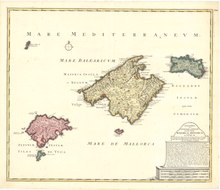
Latin
map of the Balearic Islands, with the eastern islands named
Gymnesiæ
.
 Gymnesian Islands (in dark grey)
The
Gymnesians
(
Catalan
:
Illes Gimnesies
[?im?n?zi?s]
,
Spanish
:
Gimnesias
[xim?nesjas]
), or
Gymnesic Islands
(
Catalan
:
Illes Gimnesiques
),
[1]
is a collective name given to the two largest (and easternmost)
Balearic Islands
,
Mallorca
and
Menorca
, distinguishing them from the
Pityuses
(
Catalan
:
Illes Pitiuses
;
Spanish
:
Pitiusas
), or Pine Islands,
Ibiza
and
Formentera
.
Etymology
[
edit
]
The word
Gymnesian
(from the
Greek
:
γυμν?τε?
gymnetes
) means 'naked'. The Greeks called the islands Gymnesiae (
Ancient Greek
:
Γυμν?σιαι
). According to
Diodorus Siculus
the Greeks called the islands like this because the inhabitants were naked during the summer time.
[2]
The
Ancient Greeks
recruited the local inhabitants of these islands, the
Talaiotics
, as
slingers
. According to some researchers, this does not mean that they fought naked, but that they used much lighter armament than the
hoplites
.
Name usage
[
edit
]
Later the
Phoenicians
referred to both Mallorca and Menorca as the
Baliarides
. After the whole
archipelago
(the
Pityuses
and
Gymnesians
) came under
Roman
rule, the islands gained the overall
Latin
name
Insulae Baliares
or
Baleares Insulae
; the collective concept has continued in use in modern languages, hence ultimately the English name
Balearic Islands
.
References
[
edit
]
- Strabo
Geography
Book III, Chapter 2
- Belenguer, E.
Historia de les illes Balears
. Barcelona: Edicions 62, 2004. 525 p.
ISBN
84-297-5506-3
(volume I)
39°48′46″N
3°34′34″E
/
39.81276°N 3.57605°E
/
39.81276; 3.57605
