Nepal before the 1816 Sugauli Treaty
 Greater Nepal Map
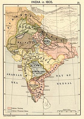 Nepal depicted on a map from the year 1805.
Greater Nepal
refers to the concept of a unified Nepal encompassing the territories within its borders during the period between 1791 and 1816.
[1]
[2]
Extensive territories in the present-day Indian states of
Uttar Pradesh
,
Bihar
,
West Bengal
and some parts of
Bangladesh
were conquered during the
unification campaign of Nepal
led by
King Prithvi Narayan Shah
.
[3]
[4]
The campaign ended with the
Anglo-Nepalese War
and the signing of the
Sugauli Treatry
between the
Kingdom of Nepal
and
East India Company
on March 4, 1816.
[5]
Background
Nepal extended from the
Sutlej
to the
Teesta River
during the
unification
initiated by
Prithvi Narayan Shah
in 1743. Gorkha rule over this expanded territory lasted only up to 1815. The Gorkhali presence in
Garhwal
was for 12 years,
Kumaon
for 24 years, and
Sikkim
for 33 years. The expansion of Gorkha ended with the 1814-1815
war with the East India Company
. The ensuing
Treaty of Sugauli
, between the Gorkhali king and the East India Company, reset Nepal's boundaries in the east and west to the present boundaries. According to the Greater Nepal advocates, this caused a loss of 176,000 km
2
of territory to Nepal.
[6]
[
better source needed
]
Advocacy
Greater Nepal Nationalist Front
Greater Nepal Nationalist Front (GNNF, formerly "Unified Nepal National Front")
[4]
[7]
is a Nepali
NGO
headed by Phanindra Nepal, which champions the cause of Greater Nepal. The organisation disowns the 1810
Sugauli Treaty
and the 1950
Treaty of Peace and Friendship
with India. It demands the return of the land that belonged to Nepal before the signing of the Sugauli Treaty. This involves land up to the
Sutlej River
in the west, the
Teesta River
in the east ("
Shimla
to
Darjeeling
" in the organisation's parlance) and extending up to
Varanasi
in the south.
[4]
Scholars Mishra and Haque state that the organisation is rhetorically very powerful. The map of Greater Nepal produced by the organisation provides power to the movement by building "meanings and nostalgic longings". The movement has a web page in the
Nepali language
, a Facebook page and blog sites.
[4]
An even more grandiose movement is said to talk about "Unified Gorkha-States of India Sub-Continent", which restructures the Indian subcontinent into five autonomous states, the largest of which is the so-called "Arya Autonomous State".
[4]
Nepali Maoists
A Maoist movement has published a 260-page Nepali book titled "
Nepal: Teesta Dekhi Satlej Samma
" ("Nepal: From Teesta to the Sutlej") which, while repeating similar demands to the GNNF, also provides copious references to alleged historical facts. Among others, it claims that the Indian prime minister
Jawaharlal Nehru
supported the idea of "Greater Nepal".
[5]
Their map includes the Indian towns of
Varanasi
,
Ballia
,
Bahraich
,
Pilibhit
and
Jaunpur
within Greater Nepal.
[8]
The Maoist leader
Prachanda
dismissed the claims in an interview with the
Times of India
as a "media-created stunt". But according to the
Times of India
the book was readily available in and around the Maoist camps along the Indo-Nepal border in 2005.
[5]
The Maoist-affiliated Indian Nepalis advocacy group
Akhil Bharat Nepali Ekta Samaj
is also supportive of the greater Nepali ideal according to some sources.
[9]
Nepali scholars
Scholars and retired officials such as
Buddhi Narayan Shrestha
(former Director of the Survey Department) and
Dwarika Nath Dhungel
(former secretary of Water Resources) have published scholarly articles with maps labelled "Greater Nepal".
[10]
[12]
Shrestha has also spoken in Greater Nepal gatherings
[13]
[14]
and made media comments in its favour, declaring "The land we lost to the East India Company should not belong to India. It is ours."
[15]
Shreshta narrates that, before the Sugauli Treaty, Nepal extended up to the confluence of
Gandak
and
Ganges
Rivers in the south, and to
Shigatse
and
Tashilhunpo
in the north. "It was
called
the 'Greater Nepal'", he states, without mentioning who called it so.
British India apparently "did not like" Greater Nepal as a unified country and therefore dismembered it.
He alleges that the British wanted to expand trade into Tibet but, since Nepal stood in the way, they needed to cut it down.
Official positions
No king of Nepal has ever discussed or approved of the concept of "Greater Nepal".
[
citation needed
]
However, upon forming a coalition government after the
2008 Nepali Constituent Assembly election
, the leader of the
Communist Party of Nepal (Maoist)
and then-prime minister
Pushpa Kamal Dahal
(popularly known as "Prachanda") stated that the
1950 Indo-Nepal Treaty of Peace and Friendship
would be "scrapped".
[19]
However, the matter was pursued no further. He resigned nine months later for other reasons. Late Nepali Prime Minister
Girija Prasad Koirala
called the idea of Greater Nepal "a product of unstable minds". According to
Kanak Mani Dixit
, as of 1993, the mainstream Left of Nepal appears ambivalent: "They like the concept but are unwilling to do anything about it."
[20]
In 2023 when the
Mauryan Empire
mural in India's new Parliament building appeared in the newspapers, some politicians of the ruling
Bharatiya Janata Party
started branding it an
Akhand Bharat
map. The fact that included some Nepali towns such as
Lumbini
and
Kapilavastu
produced consternation in Nepal. The mayor of Kathmandu,
Balen Shah
placed a map of
Greater Nepal
in his office as a protest.
[21]
[22]
See also
References
- ^
Verma, Jai Kumar (19 September 2020),
"Greater Nepal: A spark which could become a fire"
,
Aviation and defence
,
The growing concept of "Greater Nepal" is an irredentist notion which visualises to include several areas of India which were occupied by Gorkha army after conquering the neighbouring states between 1791 to 1804.
- ^
Amy Johnson,
Don’t Break the State: Indivisibility and Populist Majority Politics in Nepal
, Society for Cultural Anthropology, 16 March 2021.
- ^
Mulmi, Amish Raj.
"The Making of the Gorkha Empire: Part I ? Land"
.
The Record
. Retrieved
21 December
2021
.
- ^
a
b
c
d
e
Mishra, Swasti Vardhan; Haque, Sk. Mafizul (2020),
"Geographies of India-Nepal contestation"
,
osf.io
- ^
a
b
c
"Nepal Maoists produce maps to claim parts of India"
.
Times of India
. 25 October 2005.
- ^
Pande, Puran Ch.; Pande, Ravindra K.; Pande, Rajnish (1998).
The Himalayan Environment: Issues and Challenges
. Daya Publishing House. p. 76.
ISBN
978-81-7035-187-0
.
- ^
Shambhu Bhujel, Nepali teacher campaigns for "Greater Nepal", Xinhua News Agency, 4 July 2009.
ProQuest
451767580
- ^
Nayak, Nihar (2010). "India?Nepal Peace and Friendship Treaty (1950): Does it Require Revision?".
Strategic Analysis
.
34
(4). page 591, note 20.
doi
:
10.1080/09700161003802778
.
S2CID
154483196
.
- ^
"Extremist Group - Akhil Bharat Nepali Ekta Samaj (ABNES)"
.
www.satp.org
. Retrieved
2023-11-11
.
- ^
“My greater Nepal” released
, People's Review (Kathmandu), 15 May 2019. "'My Greater Nepal', a compilation of patriotic articles of ten senior writers was released on Thursday last week amidst a function in Kathmandu. Edited and published by senior journalist Rajan Karki, the compilation in English includes analytical articles on Nepal by Bharat Dahal, Nepal's border expert Buddhinarayan Shrestha, senior journalist N.P Upadhaya, author Prof. Dr. Shastra Dutta Pant, water resource expert Ratna Sansar Shrestha, patriotism campaigner Dirgharaj Prasai, citizenship awareness campaigner Sadhya Bahadur Bhandari, analysts Premsagar Poudel and Basanta Khadka."
- ^
Dhungel, Dwarika Nath; Pun, Santa Bahadur (2014),
"Nepal-India Relations: Territorial/Border Issue with Specific Reference to Mahakali River"
,
FPRC Journal
, New Delhi: Foreign Policy Research Centre – via academia.edu
- ^
Looking For Greater Nepal
, greaternepal.asia.np, retrieved 20 October 2020.
- ^
Buddhi Narayan Shrestha Speaking
, Buddhi Narayan Shrestha blog site, 16 March 2010. "Border researcher Buddhi Narayan Shrestha delivering speech in Shanti Batika, Ratna Park during displaying the Hoarding Board of the Map of Greater Nepal by United Nepal National Front on 7 March 2009."
- ^
Buddhi Narayan Shrestha: ‘We could regain Greater Nepal’
, The Kathmandu Post, 6 January 2008.
- ^
Maoists to scrap 1950 Indo-Nepal Friendship Treaty
, Rediff News, 24 April 2008.
- ^
Kanak Mani Dixit
,
Looking for Greater Nepal
, Himal SouthAsian, 1 March 1993.
- ^
"Amid Akhanda Bharat map row, KMC Mayor Balen Shah displays a map of 'Greater Nepal' at his office"
.
My Republica
. 8 June 2023.
- ^
"????? ????? ???? ?????? ??????????? ?????? ???????? ?????, ?? ?????? ????? ????? ? ? - ???????? ????"
. 8 June 2023.
Bibliography
- Shrestha, Buddhi N. (2013),
"Demarcation of the International Boundaries of Nepal"
(PDF)
, in Haim Srebro (ed.),
International Boundary Making
, Copenhagen: International Federation of Surveyors, pp. 149?182,
ISBN
978-87-92853-08-0
- Whelpton, John (1997),
"Political Identity in Nepal: State, Nation and Community"
, in David N. Gellner; Joanna Pfaff-Czarnecka; John Whelpton (eds.),
Nationalism and Ethnicity in a Hindu Kingdom: The Politics of Culture in Contemporary Nepal
, Routledge, pp. 39?78,
ISBN
978-90-5702-089-6
- Whelpton, John (2005),
A History of Nepal
, Cambridge University Press,
ISBN
978-0-521-80470-7
External links
|
|---|
| Ideologies
| | Ethnic
| |
|---|
| Religious
| |
|---|
| Territorial
| |
|---|
|
|---|
| Organisations
| |
|---|
| Events
| |
|---|
|
|---|
| Africa
| |
|---|
| North America
| |
|---|
| South America
| |
|---|
| Western Asia
| |
|---|
| Southern Asia
| |
|---|
| Central Asia
| |
|---|
| Eastern and Southeastern Asia
| |
|---|
| Central and Eastern Europe
| |
|---|
| Southern Europe
| |
|---|
| Northern Europe
| |
|---|
| Western Europe
| |
|---|
| Oceania
| |
|---|
|