 Llaima
volcano in eruption
Llaima
volcano in eruption
The
geology of Chile
is a characterized by processes linked to
subduction
, such as
volcanism
,
earthquakes
, and
orogeny
. The
building blocks
of Chile's geology were
assembled
during the
Paleozoic Era
when Chile was the southwestern margin of the supercontinent
Gondwana
. In the
Jurassic
, Gondwana began to split, and the ongoing period of
crustal deformation
and
mountain building
known as the
Andean orogeny
began. In the
Late Cenozoic
, Chile definitely separated from Antarctica, and the Andes experienced a significant rise accompanied by a cooling climate and the onset of
glaciations
.
The subduction interactions shaped four main
morphostructures
of Chile: the
Andes
, the
Intermediate Depression
, the
Coast Range
, and the
Peru?Chile Trench
off the coast. Since Chile is on an active
continental margin
, it has many
volcanoes
. Almost the entire country is subject to earthquakes arising from strains in the
Nazca
and
Antarctic Plates
or shallow
strike-slip faults
. Northern Chilean mineral resources are a major economic resource, and the country is the leading producer of
copper
,
lithium
and
molybdenum
. Most of these mineral deposits were created from
magmatic
hydrothermal
activity, and the water required to form those deposits derived from the subducted slab of the oceanic crust beneath the Andes.
The Chilean
Easter Island
and
Juan Fernandez Archipelago
are volcanic
hotspot
islands in the eastward-moving Nazca plate. The geology of the
Chilean Antarctic Territory
has various commonalities with that of mainland Chile.
General characteristics
[
edit
]
The three primary morphological features derived from the Andes are the Andes Mountains proper, the Chilean Coast Range and the Chilean Central Valley, also known as the Intermediate Depression and the Longitudinal Valley. The mountains run parallel in a north-south direction from
Morro de Arica
to
Taitao Peninsula
, making up most of Chile's land surface. South of Taitao, only the Andes Mountains are present.
North of the Taitao Peninsula, the Peru?Chile Trench
subduction zone
is the boundary between the South American and Nazca Plates. At Taitao, the
Chile Triple Junction
and the
Nazca Plate
subduct the South American Plate.
The Andes
[
edit
]
 The Andes are generally higher in northern Chile.
In
Norte Grande
the mountains form a series of
plateaus
, such as
Puna de Atacama
and the
Altiplano
. At a south latitude of 27 degrees, Chile's highest mountain (
Ojos del Salado
) reaches a height of 6,893 metres (22,615 ft). Below 42 degrees south, the Andes split into a
fjord
landscape and the highest mountain is
Monte San Valentin
at 4,058 metres (13,314 ft) at north of
Northern Patagonian Ice Field
. As the mountains ebb, the
snow line
lowers; in the
Llanquihue
it is at 1,200 metres (3,900 ft), and 900 metres (3,000 ft) in the
Magallanes
.
Intermediate Depression
[
edit
]
The Intermediate Depression, a series of faults running north to south, separates the Andes from the Coast Range with a steady decrease in altitude as the latitude increases. In
Norte Grande
the Intermediate Depression is partially covered by a series of
salt flats
, and has the world's largest
potassium nitrate
deposits. In
Norte Chico
, the depression disappears briefly before reappearing in a narrow valley at
Santiago
. From the narrows southward the valley widens until it is interrupted near
Loncoche
by the
Bahia Mansa Metamorphic Complex
(part of the Coast Range), then widening at
Los Llanos
(near
Paillaco
). In central and southern Chile (33°?42° south), the landscape is partially covered with glacial
sediments
from the Andes. In
Zona Austral
(south of 42° south) the depression dips below
sea level
, appearing occasionally in islands such as
Chiloe
. Its southern end is the
Isthmus of Ofqui
.
Chilean Coast Range
[
edit
]
The
Chilean Coast Range
runs southward along the coast (parallel to the Andes) from
Morro de Arica
to
Taitao Peninsula
, ending at the
Chile Triple Junction
. The range, a combined
horst
,
forearc high
and
accretionary wedge
, was separated from the Andes during the
Tertiary
rise due to the
subsidence
of the Intermediate Depression.
Geologic history
[
edit
]
 Pangaea
separation animation
Pangaea
separation animation
 View of the Altiplano plateau in northern Chile
 The mountains at
Torres del Paine National Park
have been heavily eroded by the
Quaternary
glaciations.
The mountains at
Torres del Paine National Park
have been heavily eroded by the
Quaternary
glaciations.
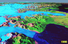 Retreat of the
San Rafael Glacier
from 1990 to 2000
Retreat of the
San Rafael Glacier
from 1990 to 2000
Paleozoic Era
[
edit
]
The oldest rocks in Chile are
micaceous
schists
,
phyllites
,
gneisses
and
quartzites
, many examples of which are found in the
Coast Range
of south-central Chile. The schists of
southern Chile
were initially formed by sediment in the proto-Pacific Ocean, and later metamorphosed in the
forearc
wedge of the Peru?Chile Trench.
Mesozoic Era
[
edit
]
During the
Triassic
Period about 250 million years ago Chile was part of the
supercontinent
Pangaea
, which concentrated the world's major land masses.
Africa
,
Antarctica
,
Australia
and
India
were near Chile. When Pangaea began to split apart during the
Jurassic
period, South America and the adjacent land masses formed
Gondwana
. Floral affinities among these now-distant landmasses date from the Gondwanaland period. South America separated from Antarctica and Australia 27 million years ago with the development of the
Drake Passage
. Across the 1,000-kilometre (620 mi)-wide Drake Passage lie the mountains of the
Antarctic Peninsula
, south of the Scotia Plate, which appear to be a continuation of the Andes. In the extreme south, the
Magallanes?Fagnano Fault
separates
Tierra del Fuego
from the small
Scotia Plate
.
The formation of the Andes began during the Jurassic. During the
Cretaceous
, the Andes began to assume their present form by the uplifting,
faulting
and
folding
of
sedimentary
and
metamorphic rocks
of ancient
cratons
. Tectonic forces along the
subduction zone
along the west coast of South America continue to their
orogenesis
, resulting in earthquakes and volcanic eruptions to this day.
Cenozoic Era
[
edit
]
The
Altiplano
plateau
was formed during the
Tertiary
, with several mechanisms proposed; all attempt to explain why the topography of the Andes incorporates a large area of low relief at high altitude (high plateau):
- Existence of weaknesses in the Earth's crust prior to tectonic shortening. Such weaknesses would cause the partition of tectonic deformation and uplift into eastern and western cordillera, leaving the necessary space for the formation of the Altiplano basin.
- Magmatic processes rooted in the asthenosphere might have contributed to uplift the plateau.
- Climate controlled the spatial distribution of erosion and sediment deposition, creating the lubrication along the Nazca Plate subduction and hence influencing the transmission of tectonic forces into South America.
- Climate also determined the formation of internal drainage (endorheism) and sediment trapping within the Andes, potentially blocking tectonic deformation in the area between the two cordilleras.
Quaternary
[
edit
]
The
Quaternary
glaciations
left visible marks in most parts of Chile, particularly
Zona Sur
and
Zona Austral
. These include
ice fields
,
fjords
,
glacial lakes
and u-shaped valleys. During the
Santa Maria glaciation
glaciers extended into the Pacific Ocean at 42° south, dividing the
Chilean Coast Range
and creating what is now
Chacao Channel
.
Chiloe
, part of the Chilean Coast Range, became an island. South of Chacao Channel, Chile's coast is split by fjords, islands and channels; these glaciers created
moraines
at the edges of the Patagonian lakes, changing their outlets to the Pacific and shifting the
continental divide
. The remnants of the
Patagonian Ice Sheet
which covered large parts of Chile and
Argentina
are the
Northern
and the
Southern Patagonian Ice Fields
.
It has been suggested that from 1675 to 1850 the
San Rafael Glacier
advanced during the
Little Ice Age
. The first documented visit to the area was made in 1675 by the Spanish explorer
Antonio de Vea
, who entered
San Rafael Lagoon
through
Rio Tempanos
("Ice Floe River") without mentioning the many
ice floes
for which the river is named. De Vea also wrote that the
San Rafael Glacier
did not reach far into the lagoon. In 1766 another expedition noticed that the glacier did reach the lagoon and had
calved
into
icebergs
.
Hans Steffen
visited the area in 1898, noting that the glacier now penetrated far into the lagoon. As of 2001, the glacier has retreated behind its 1675 border due to climate change.
[1]
Pacific islands
[
edit
]
 Most of the
moai
on Easter island are carved from
volcanic
tuff
.
Most of the
moai
on Easter island are carved from
volcanic
tuff
.
Easter Island
is a
volcanic island
consisting of three extinct volcanoes:
Terevaka
, at an altitude of 507 metres (1,663 ft), forms the bulk of the island. Two other volcanoes (
Poike
and
Rano Kau
) form the eastern and southern headlands, giving the island its triangular shape. There are numerous lesser cones and other volcanic features: the crater
Rano Raraku
, the
cinder cone
Puna Pau
and many volcanic caves (including
lava tubes
).
Easter Island and its surrounding islets, including
Motu Nui
and
Motu Iti
, form the comminuted apex of a large volcanic mountain rising over 2,000 metres (6,600 ft) from the seabed. It is part of the Sala y Gomez Ridge, a mostly-submarine mountain range with dozens of
seamounts
.
Pukao
and
Moai
are two seamounts west of Easter Island, extending 2,700 km (1,700 mi) east to the
Nazca Seamount
. Pukao, Moai and Easter Island were formed during the last 750,000 years, with the last eruption a little over 100,000 years ago. These are the youngest mountains of the Sala y Gomez Ridge, which was formed by the
Nazca Plate
floating over the
Easter hotspot
.
[2]
Only on Easter Island is the Sala y Gomez Ridge dry land.
The
volcanic
Juan Fernandez Islands
were created by a
hotspot
in the Earth's mantle penetrating the
Nazca Plate
. The islands were carried eastward as the plate subducted the
South American
continent.
Radiometric dating
indicates that Santa Clara is the oldest of the islands (at 5.8 million years), followed by Robinson Crusoe (3.8?4.2 million years) and Alexander Selkirk (1.0?2.4 million years). Robinson Crusoe is the largest of the islands at 93 square kilometres (36 sq mi), and its highest peak (El Yunque) is 916 metres (3,005 ft) high. Alexander Selkirk covers 50 square kilometres (19 sq mi), and its highest peak is Los Innocentes at 1,319 metres (4,327 ft). Santa Clara covers 2.2 square kilometres (540 acres), reaching an elevation of 350 metres (1,150 ft).
Economic geology
[
edit
]
Mining
[
edit
]
 Chuquicamata
copper mine in 1984
Chuquicamata
copper mine in 1984
Chile has the world's largest
copper
reserves, and is the largest producer and exporter of the metal.
[3]
Notable copper mines include
Chuquicamata
and
Escondida
. Chile accounts for five percent of the Western Hemisphere's
gold
production, of which 41 percent is a by-product of
copper extraction
.
[3]
The country holds the largest world reserves of
rhenium
[3]
and
potassium nitrate
, and its reserves of
molybdenum
are estimated to be the third-largest in the world.
[3]
Most of Chile's mineral resources are in
the north
;
gas
,
coal
and
oil
reserves, in the southern
Magallanes Region
, are sufficient for local needs.
Guarello Island
, in the Magallanes Region, has the world's southernmost
limestone
mine.
Geothermal energy
[
edit
]
Since 2000, geothermal exploration and concessions have been regulated by the
Law of Geothermal Concessions
(
Spanish
:
Ley de Concesiones de Energia Geotermica
). The Chilean company Geotermia del Pacifico, with support from
CORFO
, is exploring a location in
Curacautin
as a site for a
geothermal power plant
. Geotermia del Paicifco's studies indicated that two geothermal fields near Curacautin could be used for energy production, with a combined capacity to supply 36,000 homes in 2010. One area to be developed is located near the
Tolhuaca
hot springs, and the other is in Rio Blanco Springs.
[4]
Another area under consideration for geothermal production is
Cordon Caulle
.
Tourism
[
edit
]
Although geology-focused tourism is rare, there are some sites in which the local geology is a major attraction (for example, the copper mine at
Chuquicamata
).
Geological hazards
[
edit
]
 Map of Valparaiso after the earthquake of 16 August 1906
Area of the city most affected by earthquake
City blocks most damaged by fire
Earthquakes
,
volcanic eruptions
and
mass ground movements
are frequent occurrences. The subduction zone along Chile's coast has produced the most powerful earthquake ever recorded, the
1960 Valdivia earthquake
. Earthquakes are notorious for triggering volcanic eruptions, such as the
1960 Cordon Caulle eruption
. Chilean earthquakes have produced tsunamis.
Landslides occur frequently in the Andes, most following earthquakes. The
2007 Aysen Fjord earthquakes
produced several landslides along the Fjords Mountains, spawning a tsunami.
Lahars
are among the most lethal volcanic hazards in Chile; a lahar destroyed the original site of
Conaripe
.
Earthquakes
[
edit
]
Major earthquakes in Chile occur in a small number of source areas. Those affecting coastal regions are generally aligned offshore from Concepcion southward, with the major epicenters producing a predictable pattern of seismic and tsunami effects.
[5]
The first systematic seismological recordings in Chile began after
an earthquake and fire
devastated Valparaiso in 1906.
[6]
Earthquakes in northern Chile are known to have caused both
uplift
and
subsidence
of the continent. Large earthquakes of
Magnitude
8 or more are associated with subsidence and drowning of the Chilean coast, except peninsulas and offshore islands. Magnitude 7 to 8 earthquakes with a source area near an internal boundary of the Earth known as the
Moho
are known to result in uplift of the coast. Earthquakes near the Moho may account for permanent
deformation
of the western edge of
South American plate
that accumulates into a long-term net uplift of the continent.
[7]
Quake clusters
[
edit
]
Although the most powerful six quakes recorded were clustered in two time periods (a 12-year span from 1952 to 1964 and a seven-year span from 2004 to 2011), this is considered a statistical anomaly.
[8]
The phenomenon of comparably-large quakes on the same (or neighboring) faults within months of each other may be explained by geological mechanisms, but this does not fully demonstrate a relationship between events separated by longer periods and greater distances
[9]
See also
[
edit
]
Notes
[
edit
]
- ^
Araneda, Alberto; Torrejon, Fernando; Aguayo, Mauricio; Torres, Laura; Cruces, Fabiola; Cisternas, Marco; Urrutia, Roberto (November 2007). "Historical records of San Rafael glacier advances (North Patagonian Icefield): another clue to 'Little Ice Age' timing in southern Chile?".
The Holocene
.
17
(7): 987?998.
Bibcode
:
2007Holoc..17..987A
.
doi
:
10.1177/0959683607082414
.
hdl
:
10533/178477
.
S2CID
128826804
.
- ^
Haase, Karsten & Stoffers, P & Garbe-Schonberg, Dieter. (1997).
The Petrogenetic Evolution of Lavas from Easter Island and Neighbouring Seamounts, Near-ridge Hotspot Volcanoes in the SE Pacific
. Journal of Petrology - J PETROL. 38. 785?813.
doi
:
10.1093/petrology/38.6.785
.
- ^
a
b
c
d
U.S. Geological Survey (2005).
Minerals Yearbook 2005.
- ^
"Chile Could Have Geothermal Energy By 2010"
.
Santiago Times
- ^
Lomnitz, Cinna
;
"Major earthquakes and tsunamis in Chile during the period 1535 to 1955"
;
International Journal of Earth Sciences
, Vol. 59, No. 3; abstract.
- ^
Moreno, Teresa. (2006).
The Geology of Chile,
p. 264.
, p. 264, at
Google Books
- ^
Melnick, Daniel (2016). "Rise of the central Andean coast by earthquakes straddling the Moho".
Nature Geoscience
.
9
(5): 401?408.
Bibcode
:
2016NatGe...9..401M
.
doi
:
10.1038/NGEO2683
.
- ^
Pappas, Stephanie.
"Sumatra, Japan, Chile: Are Earthquakes Getting Worse?"
;
LiveScience
; 11 March 2011.
- ^
Brahic, Catherine;
"The mega-quake connection: Are huge earthquakes linked?"
;
New Scientist
; UK; 16 March 2011.
References
[
edit
]
External links
[
edit
]
|
|---|
| Terranes
| |
|---|
Sedimentary
formations
and groups
| |
|---|
| Batholiths
| |
|---|
Metamorphic
complexes
| |
|---|
| Faults
| |
|---|
|