Nepal
measures about 880 kilometers (547 mi) along its Himalayan axis by 150 to 250 kilometers (93 to 155 mi) across. It has an area of 147,516 km
2
(56,956 sq mi).
[1]
Nepal is landlocked by
China
's
Tibet Autonomous Region
to the north and India on other three sides.
West Bengal
's narrow
Siliguri Corridor
separate Nepal and
Bangladesh
. To the east are
Bhutan
and
India
.
Nepal has a very high degree of geographic diversity and can be divided into three main regions: Terai, Hilly, and Himal. The Terai region, covering 17% of Nepal's area, is a lowland region with some hill ranges and is culturally more similar to parts of India. The Hilly region, encompassing 68% of the country's area, consists of mountainous terrain without snow and is inhabited by various indigenous ethnic groups. The Himal region, covering 15% of Nepal's area, contains snow and is home to several high mountain ranges, including Mount Everest, the world's highest peak.
Nepal, with elevations ranging from less than 100 meters to over 8,000 meters, has eight climate zones from tropical to perpetual snow. The majority of the country's population resides in the tropical and subtropical climate zones. The tropical zone, below 1,000 meters, experiences frost less than once per decade and is suitable for growing various fruits and crops. The subtropical climate zone, from 1,000 to 2,000 meters, is the most prevalent and suitable for growing rice, maize, millet, wheat, and other crops. The temperate climate zone, from 2,000 to 3,000 meters, occupies 12% of Nepal's land area and is suitable for cold-tolerant crops. The subalpine, alpine, and nival zones have progressively fewer human settlements and agricultural activities.
Seasons are divided into a wet season from June to September and a dry season from October to June. The summer monsoon can cause flooding and landslides, while the winter monsoon is marked by occasional rainfall and snowfall. The diverse elevation results in various biomes, including tropical savannas, subtropical and temperate forests, montane grasslands, and shrublands.
Nepal has three categories of rivers: the largest systems (Koshi, Gandaki/Narayani, Karnali/Goghra, and Mahakali), second category rivers (rising in the Middle Hills and Lower Himalayan Range), and third category rivers (rising in the outermost Siwalik foothills and mostly seasonal). These rivers can cause serious floods and pose challenges to transportation and communication networks. River management involves addressing flooding, sedimentation, and sustainable water sources for irrigation. Building dams in Nepal is controversial due to seismic activity, glacial lake formation, sedimentation rates, and cross-border equity issues between India and Nepal.
Nepal's land cover is dominated by forests, which cover 39.09% of the country's total geographical area, followed by agriculture areas at 29.83%. The hill region constitutes the largest portion of Nepal, with significant cultivated lands and natural vegetation. Forests in Nepal face deforestation due to over-harvesting of firewood, illegal logging, clearing for agriculture, and infrastructure expansion. As of 2010, 64.8% of the forested area in Nepal is covered by core forests of more than 500 ha in size. Deforestation and degradation are driven by multiple processes, including firewood harvesting, construction, urban expansion, and illegal logging.
Nepal has consistently been ranked as one of the most polluted countries in the world.
[2]
[3]
[4]
[5]
[6]
[7]
Landform regions
For a country of its size, Nepal has tremendous geographic diversity. It rises from as low as 59 metres (194 ft) elevation in the tropical
Terai
?the northern rim of the
Gangetic Plain
, through beyond the perpetual
snow line
to 90 peaks over 7,000 metres (22,966 ft) including Earth's highest (8,848-metre (29,029 ft)
Mount Everest
or
Sagarmatha
). In addition to the continuum from tropical warmth to cold comparable to polar regions, average annual precipitation varies from as little as 160 millimetres (6.3 in) in its narrow proportion of the
rainshadow
north of the
Himalayas
to as much as 5,500 millimetres (216.5 in) on windward slopes, the maximum mainly resting on the magnitude of the
South Asian monsoon
.
[8]
Forming south-to-north transects, Nepal can be divided into three belts: Terai, Pahad and Himal. In the other direction, it is divided into three major river systems, east to west:
Koshi
,
Gandaki/Narayani
and
Karnali
(including the
Mahakali
along the western border), all tributaries of the
Ganges river
. The Ganges-
Yarlung Zangbo
/
Brahmaputra
watershed largely coincides with the Nepal-Tibet border, save for certain tributaries rising beyond it.
Himal
 Perspective
view of the Himalayas and Mount Everest as seen from space looking south-south-east from over the
Tibetan Plateau
. (
annotated version
)
Perspective
view of the Himalayas and Mount Everest as seen from space looking south-south-east from over the
Tibetan Plateau
. (
annotated version
)
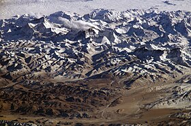
Himal Region is a mountainous region containing snow.
The Mountain Region begins where high ridges (Nepali: ???; lekh) begin substantially rising above 3,000 metres (10,000 ft) into the
subalpine
and
alpine zone
which are mainly used for seasonal pasturage. By geographical view, it covers 15% of the total area of Nepal. A few tens kilometers further north the high Himalaya abruptly rise along the Main Central Thrust fault zone above the
snow line
at 5,000 to 5,500 metres (16,400 to 18,000 ft). Some 90 of Nepal's peaks exceed 7,000 metres (23,000 ft) and eight exceed 8,000 metres (26,247 ft) including
Mount Everest
at 8,848 metres (29,029 ft) and
Kanchenjunga
at 8,598 metres (28,209 ft).
There are some 20 subranges including the
Kanchenjunga
massif along with the
Mahalangur Himal
around Mount Everest.
Langtang
north of Kathmandu,
Annapurna
and
Manaslu
north of Pokhara, then
Dhaulagiri
further west with
Kanjiroba
north of
Jumla
and finally
Gurans Himal
in the far west.
Nepal’s highest mountains
[9]
| Mountain
|
Height
|
Section
|
Location
|
Mount Everest
(Highest in the world)
|
8,848 m
|
29,029 ft
|
Khumbu
Mahalangur
|
Khumbu Pasanglhamu
,
Solukhumbu District
,
Province No. 1
(Nepal-China Border)
|
Kangchenjunga
(3rd highest in the world)
|
8,586 m
|
28,169 ft
|
Northern Kanchenjunga
|
Phaktanglung
/
Sirijangha
,
Taplejung District
,
Province No. 1
(Nepal-India Border)
|
Lhotse
(4th highest in the world)
|
8,516 m
|
27,940 ft
|
Everest Group
|
Khumbu Pasanglhamu
,
Solukhumbu District
,
Province No. 1
(Nepal-China Border)
|
Makalu
(5th highest in the world)
|
8,462 m
|
27,762 ft
|
Makalu Mahalangur
|
Makalu
,
Sankhuwasabha District
,
Province No. 1
(Nepal-China Border)
|
Cho Oyu
(6th highest in the world)
|
8,201 m
|
26,906 ft
|
Khumbu Mahalangur
|
Khumbu Pasanglhamu
,
Solukhumbu District
,
Province No. 1
(Nepal-China Border)
|
Dhaulagiri
(7th highest in the world)
|
8,167 m
|
26,795 ft
|
Dhaulagiri
|
Dhaulagiri,
Myagdi District
,
Gandaki Province
|
Manaslu
(8th highest in the world)
|
8,163 m
|
26,759 ft
|
Mansiri Himal
|
Tsum Nubri,
Gorkha District
/ Nashong,
Manang District
,
Gandaki Province
|
Annapurna
(10th highest in the world)
|
8,091 m
|
26,545 ft
|
Annapurna Massif
|
Annapurna,
Kaski District
/ Annapurna,
Myagdi District
,
Gandaki Province
|
Trans-Himalayan
The main watershed between the
Brahmaputra
(called
Yarlung Tsangpo
in
Tibet
) and the
Ganges
system (including all of Nepal) actually lies north of the highest ranges. Alpine, often semi-arid valleys?including
Humla
,
Jumla
,
Dolpo
,
Mustang
,
Manang
and
Khumbu
?cut between Himalayan sub ranges or lie north of them.
Some of these valleys historically were more accessible from
Tibet
than Nepal and are populated by people with
Tibetan
affinities called
Bhotiya
or
Bhutia
including the famous
Sherpas
in Kumbu valley near Mount Everest. With
Chinese cultural hegemony
in Tibet itself, these valleys have become repositories of traditional ways. Valleys with better access from the hill regions to the south are culturally linked to Nepal as well as Tibet, notably the
Kali Gandaki Gorge
where
Thakali
culture shows influences in both directions.
Permanent villages in the mountain region stand as high as 4,500 metres (15,000 ft) with summer encampments even higher. Bhotiyas graze
yaks
, grow cold-tolerant crops such as
potatoes
,
barley
,
buckwheat
and
millet
. They traditionally traded across the mountains, e.g., Tibetan salt for
rice
from lowlands in Nepal and India. Since trade was restricted in the 1950s they have found work as high altitude porters, guides, cooks and other accessories to tourism and alpinism.
[10]
Hilly
 Middle Hills
Hilly Region is a mountain region which does not generally contain snow. It is situated to the south of the Himal Region (the snowy mountain region). This region begins at the
Lower Himalayan Range
, where a fault system called the
Main Boundary Thrust
creates an escarpment 1,000 to 1,500 metres (3,000 to 5,000 ft) high, to a crest between 1,500 and 2,700 metres (5,000 and 9,000 ft). It covers 68% of the total area of Nepal.
These steep southern slopes are nearly uninhabited, thus an effective buffer between languages and culture in the Terai and Hilly.
Paharis
mainly populate river and stream bottoms that enable
rice cultivation
and are warm enough for winter/spring crops of
wheat
and
potato
. The increasingly urbanized
Kathmandu
and
Pokhara
valleys fall within the Hill region.
Newars
are an
indigenous
ethnic group with their own
Tibeto-Burman
language
. The Newar were originally indigenous to the Kathmandu valley but have spread into Pokhara and
other towns
alongside urbanized Pahari.
Other indigenous Janajati ethnic groups -? natively speaking highly localized Tibeto-Burman languages and dialects -? populate hillsides up to about 2,500 metres (8,000 ft). This group includes
Magar
and
Kham Magar
west of Pokhara,
Gurung
south of the Annapurnas,
Tamang
around the periphery of Kathmandu Valley and
Rai
,
Koinch Sunuwar
and
Limbu
further east. Temperate and subtropical fruits are grown as cash crops.
Marijuana
was grown and processed into
Charas
(
hashish
) until international pressure persuaded the
government
to outlaw it in 1976. There is increasing reliance on animal husbandry with elevation, using land above 2,000 metres (7,000 ft) for summer grazing and
moving herds to lower elevations in winter
. Grain production has not kept pace with population growth at elevations above 1,000 metres (3,300 ft) where colder temperatures inhibit
double cropping
. Food deficits drive emigration out of the Pahad in search of employment.
The Hilly ends where ridges begin substantially rising out of the
temperate climate
zone into
subalpine zone
above 3,000 metres (10,000 ft).
Terai
Terai is a low land region containing some hill ranges. Looking out for its coverage, it covers 17% of the total area of Nepal. The Terai (also spelt Tarai) region begins at the Indian border and includes the southernmost part of the flat, intensively farmed
Gangetic Plain
called the
Outer Terai
. By the 19th century, timber and other resources were being exported to India. Industrialization based on agricultural products such as
jute
began in the 1930s and infrastructure such as roadways, railways and electricity were extended across the border before it reached Nepal's Pahad region.
The Outer Terai is culturally more similar to adjacent parts of India's
Bihar
and
Uttar Pradesh
than to the Pahad of Nepal.
Nepali
is taught in schools and often spoken in government offices, however, the local population mostly uses
Maithali
,
Bhojpuri
and
Tharu
languages.
The Outer Terai ends at the base of the first range of foothills called the
Siwaliks
or
Churia
. This range has a densely forested skirt of coarse alluvium called the
Bhabhar
. Below the Bhabhar, finer, less permeable sediments force groundwater to the surface in a zone of springs and marshes. In
Persian
,
terai
refers to wet or marshy ground. Before the use of
DDT
this was dangerously
malarial
. Nepal's rulers used this for a defensive frontier called the
char kose jhadi
(four
kos
forest, one kos equaling about three kilometers or two miles).
Above the Bhabhar belt, the Siwaliks rise to about 700 metres (2,297 ft) with peaks as high as 1,000 metres (3,281 ft), steeper on their southern flanks because of faults are known as the Main Frontal Thrust. This range is composed of poorly consolidated, coarse sediments that do not retain water or support soil development so there is virtually no agricultural potential and sparse population.
In several places beyond the Siwaliks, there are
d?n valleys
called
Inner Terai
. These valleys have productive soil but were dangerously malarial except to
indigenous
Tharu people
who had
genetic resistance
. In the mid-1950s
DDT
came into use to
suppress mosquitos
and the way was open to settlement from the land-poor hills, to the detriment of the Tharu.
The Terai ends and the Pahad begin at a higher range of foothills called the
Lower Himalayan Range
.
Climate
 Nepal map of Koppen climate classification zones
Altitudinal belts
 Satellite image of Nepal in October 2002
Nepal's latitude is about the same as that of the United States state of
Florida
, however with elevations ranging from less than 100 meters (300 ft) to over 8,000 meters (26,000 ft) and precipitation from 160 millimeters (6 in) to over 5,000 millimeters (16 ft) the country has eight climate zones from tropical to perpetual snow.
[11]
The
tropical
zone
below 1,000 meters (3,300 ft) experiences
frost
less than once per decade. It can be subdivided into lower tropical (below 300 meters or 1,000 ft.) with 18% of the nation's land area) and upper (18% of land area) tropical zones. The best
mangoes
and well as
papaya
and
banana
are largely confined to the lower zone. Other fruit such as
litchee
,
jackfruit
,
citrus
and mangoes of lower quality grow in the upper tropical zone as well. Winter crops include grains and vegetables typically grown in temperate climates. The Outer Terai is virtually all in the lower tropical zone. Inner Terai valleys span both tropical zones. The Sivalik Hills are mostly upper tropical. Tropical climate zones extend far upriver valleys across the Middle Hills and even into the Mountain regions.
The
subtropical
climate zone
from 1,000 to 2,000 meters (3,300 to 6,600 ft) occupies 22% of Nepal's land area and is the most prevalent climate of the Middle Hills above river valleys. It experiences frost up to 53 days per year, however, this varies greatly with elevation, proximity to high mountains and terrain either draining or ponding cold air drainage. Crops include
rice
,
maize
,
millet
,
wheat
,
potato
,
stone fruits
and citrus.
The great majority of Nepal's population occupies the tropical and subtropical climate zones. In the Middle Hills, "upper-caste" Hindus are concentrated in tropical valleys which are well suited for rice cultivation while
Janajati
ethnic groups mostly live above in the subtropical zone and grow other grains more than rice.
The
Temperate climate
zone
from 2,000 to 3,000 meters (6,600 to 9,800 ft) occupies 12% of Nepal's land area and has up to 153 annual days of frost. It is encountered in higher parts of the Middle Hills and throughout much of the Mountain region. Crops include cold-tolerant rice, maize, wheat,
barley
, potato,
apple
,
walnut
,
peach
, various cole,
amaranthus
and
buckwheat
.
The
Subalpine
zone
from 3,000 to 4,000 meters (9,800 to 13,100 ft) occupies 9% of Nepal's land area, mainly in the Mountain and Himalayan regions. It has permanent settlements in the Himalaya, but further south it is only seasonally occupied as pasture for sheep, goats, yak and hybrids in warmer months. There are up to 229 annual days of frost here. Crops include barley, potato,
cabbage
,
cauliflower
, amaranthus, buckwheat and apple. Medicinal plants are also gathered.
The
Alpine
zone
from 4,000 to 5,000 meters (13,100 to 16,400 ft) occupies 8% of the country's land area. There are a few permanent settlements above 4,000 meters. There is virtually no plant cultivation although medicinal herbs are gathered.
Sheep
,
goats
,
yaks
and hybrids are pastured in warmer months.
Above 5,000 meters the climate becomes
Nival
and there is no human habitation or even seasonal use.
Arid and semi-arid land in the
rainshadow
of high ranges have a
Transhimalayan climate
. Population density is very low. Cultivation and husbandry conform to subalpine and alpine patterns but depend on snowmelt and streams for irrigation.
Precipitation generally decreases from east to west with increasing distance from the
Bay of Bengal
, source of the summer monsoon. Eastern Nepal gets about 2,500 mm (100 in) annually; the Kathmandu area about 1,400 mm (55 in) and western Nepal about 1,000 mm (40 in). This pattern is modified by adiabatic effects as rising air masses cool and drop their moisture content on windward slopes, then warm up as they descend so relative humidity drops. Annual precipitation reaches 5,500 mm (18 ft) on windward slopes in the
Annapurna
Himalaya beyond a relatively low stretch of the
Lower Himalayan Range
. In
rainshadows
beyond the high mountains, annual precipitation drops as low as 160 mm (6 in).
Seasons
The year is divided into a wet season from June to September?as summer warmth over Inner Asia creates a low-pressure zone that draws in moist air from the Indian Ocean?and a dry season from October to June as cold temperatures in the vast interior create a high-pressure zone causing dry air to flow outward. April and May are months of intense water stress when cumulative effects of the long dry season are exacerbated by temperatures rising over 40 °C (104 °F) in the tropical climate belt. Seasonal drought further intensifies in the
Siwaliks
hills consisting of poorly consolidated, coarse, permeable sediments that do not retain water, so hillsides are often covered with drought-tolerant scrub forest. In fact, much of Nepal's native vegetation adapted to withstand drought, but less so at higher elevations where cooler temperatures mean less water stress.
The summer
monsoon
may be preceded by a buildup of thunderstorm activity that provides water for rice seedbeds. Sustained rain on average arrives in mid-June as rising temperatures over
Inner Asia
creates a low-pressure zone that draws in moist air from the Indian Ocean, but this can vary up to a month. Significant failure of monsoon rains historically meant drought and famine while above-normal rains still cause flooding and landslides with losses in human lives, farmland and buildings.
The monsoon also complicates transportation with roads and trails washing out while unpaved roads and airstrips may become unusable and cloud cover reduces safety margins for aviation. Rains diminish in September and generally end by mid-October, ushering in generally cool, clear, and dry weather, as well as the most relaxed and jovial period in Nepal. By this time, the harvest is completed and people are in a festive mood. The two largest and most important Hindu festivals?
Dashain
and
Tihar
(
Dipawali
)?arrive during this period, about one month apart. The post-monsoon season lasts until about December.
After the post-monsoon comes the winter monsoon, a strong northeasterly flow marked by occasional, short rainfalls in the lowlands and plains and snowfalls in the high-altitude areas. In this season the Himalayas function as a barrier to cold air masses from Inner Asia, so southern Nepal and northern India have warmer winters than would otherwise be the case. April and May are dry and hot, especially below 1,200 meters (4,000 ft) where afternoon temperatures may exceed 40 °C (104 °F).
Environment
The dramatic changes in elevation along this transect result in a variety of
biomes
, from
tropical savannas
along the Indian border, to
subtropical
broadleaf
and
coniferous forests
in the hills, to
temperate
broadleaf
and
coniferous
forests on the slopes of the Himalaya, to
montane grasslands and shrublands
, and finally rock and ice at the highest elevations.
This corresponds to the
Terai-Duar savanna and grasslands
ecoregion.
Subtropical forests dominate the lower elevations of the Hill region. They form a mosaic running east?west across Nepal, with
Himalayan subtropical broadleaf forests
between 500 and 1,000 meters (1,600 and 3,300 ft) and
Himalayan subtropical pine forests
between 1,000 and 2,000 meters (3,300 and 6,600 ft). At higher elevations, to 3,000 meters (10,000 ft), are found temperate broadleaf forests:
eastern Himalayan broadleaf forests
to the east of the
Gandaki River
and
western Himalayan broadleaf forests
to the west.
The native forests of the Mountain region change from east to west as precipitation decreases. They can be broadly classified by their relation to the Gandaki River. From 3,000 to 4,000 meters (10,000 to 13,000 ft) are the
eastern
and
western Himalayan subalpine conifer forests
. To 5,500 meters (18,000 ft) are the
eastern
and
western Himalayan alpine shrub and meadows
.
Environmental issues
- Natural hazards
- Earthquakes
, severe
thunderstorms
(
tornadoes
are rare
[12]
),
flooding
and flash
flooding
,
landslides
,
drought
, and
famine
depending on the timing, intensity, and duration of the summer
monsoons
- Environment - current issues
- Deforestation
(overuse of wood for fuel and lack of alternatives); contaminated water (with human and animal wastes, agricultural runoff, and industrial effluents); wildlife conservation; vehicular emissions
- Environment - international agreements
-
- Party to: Biodiversity, Climate Change, Climate Change-
Kyoto Protocol
,
Desertification
, Endangered Species, Hazardous Wastes,
Law of the Sea
,
Ozone Layer Protection
, Tropical Timber 83, Tropical Timber 94, Wetlands
- Signed, but not ratified: Marine Life Conservation
- Existing and proposed dams, barrages and canals for flood control, irrigation and hydroelectric generation
River systems
Nepal has three categories of rivers. The largest systems -? from east to west the
Koshi
,
Gandaki/Narayani
,
Karnali/Goghra
and
Mahakali
?originate in multiple
tributaries
rising in or beyond the high Himalaya that maintain substantial flows from snowmelt through the hot, drought-stricken spring before the summer
monsoon
. These tributaries cross the highest mountains in deep gorges, flow south through the Middle Hills, then join in
candelabra
-like configuration before crossing the
Lower Himalayan Range
and emerging onto the plains where they have deposited
megafans
exceeding 10,000 km
2
(4,000 sq mi) in area.
The Koshi is also called
Sapta Koshi
for its seven Himalayan tributaries in eastern Nepal:
Indrawati
,
Sun Koshi
, Tama Koshi,
Dudh Koshi
, Liku,
Arun
, and
Tamor
. The Arun rises in Tibet some 150 kilometers (100 mi) beyond Nepal's northern border. A tributary of the Sun Koshi,
Bhote Koshi
also rises in Tibet and is followed by the
Arniko Highway
connecting
Kathmandu
and
Lhasa
.
The
Gandaki/Narayani
has seven Himalayan tributaries in the center of the country:
Daraundi
,
Seti Gandaki
, Madi, Kali,
Marsyandi
, Budhi, and
Trisuli
also called
Sapta Gandaki
. The
Kali Gandaki
rises on the edge of the
Tibetan Plateau
and flows through the semi-independent
Kingdom of Mustang
, then between the 8,000 meter
Dhaulagiri
and
Annapurna
ranges in the
world's deepest valley
. The Trisuli rises north of the international border inside Tibet. After the seven upper tributaries join, the river becomes the
Narayani
inside Nepal and is joined by the East Rapti from
Chitwan Valley
. Crossing into
India
, its name changes to
Gandak
.
The
Karnali
drains western Nepal, with the
Bheri
and
Seti
as major tributaries. The upper Bheri drains
Dolpo
, a remote valley beyond the
Dhaulagiri
Himalaya with traditional Tibetan cultural affinities. The upper Karnali rises inside Tibet near-sacred
Lake Manasarovar
and
Mount Kailash
. The area around these features is the hydrographic nexus of
South Asia
since it holds the sources of the
Indus
and its major tributary the
Sutlej
, the Karnali?a
Ganges tributary
?and the
Yarlung Tsangpo
/
Brahmaputra
. It is the centre of the universe according to
traditional cosmography
. The
Mahakali
or
Kali
along the Nepal-India border on the west joins the Karnali in India, where the river is known as
Goghra
or
Ghaghara
.
Second category
rivers rise in the Middle Hills and Lower Himalayan Range, from east to west the
Mechi
,
Kankai
and
Kamala
south of the Kosi; the
Bagmati
that drains
Kathmandu Valley
between the Kosi and Gandaki systems, then the
West Rapti
and the Babai between the Gandaki and Karnali systems. Without glacial sources, annual flow regimes in these rivers are more variable although limited flow persists through the dry season.
Third category
rivers rise in the outermost
Siwalik
foothills and are mostly seasonal.
None of these river systems supports significant commercial navigation. Instead, deep gorges create obstacles to establishing transport and communication networks and de-fragmenting the economy. Foot-trails are still the primary transportation routes in many hill districts.
 Nepal's towns, villages, rivers and peaks
River management
Rivers in all three categories are capable of causing serious floods. Koshi River in the first category caused a major flood in
August 2008
in
Bihar
state, India after breaking through a poorly maintained embankment just inside Nepal. The West Rapti in the second category is called "
Gorakhpur
's Sorrow" for its history of
urban flooding
. Third category Terai rivers are associated with flash floods.
[13]
Since uplift and erosion are more or less in equilibrium in the Himalaya, at least where the climate is humid,
[14]
rapid uplift must be balanced out by annual increments of millions tonnes of sediments washing down from the mountains; then on the plains settling out of suspension on vast
alluvial fans
over which rivers meander and change course at least every few decades, causing some experts to question whether manmade embankments can contain the problem of flooding.
[15]
Traditional
Mithila
culture along the lower Koshi in Nepal and Bihar celebrated the river as the giver of life for its fertile alluvial soil, yet also the taker of life through its catastrophic floods.
[16]
Large
reservoirs
in the Middle Hills may be able to capture peak flows and mitigate downstream flooding, to store surplus monsoon flows for dry season irrigation and to generate
electricity
. Water for irrigation is especially compelling because the Indian Terai is suspected to have entered a food bubble where dry season crops are dependent on water from
tube wells
that in the aggregate are unsustainably "mining" groundwater.
[17]
Depletion of aquifers without building upstream dams as a sustainable alternative water source could precipitate a
Malthusian catastrophe
in India's
food insecure
states
Uttar Pradesh
[
citation needed
]
and
Bihar
,
[18]
with over 300 million combined population. With India already experiencing a
Naxalite?Maoist insurgency
[19]
in Bihar,
Jharkhand
and
Andhra Pradesh
, Nepalese reluctance to agree to water projects could even seem an existential threat to India.
[20]
As Nepal builds barrages to divert more water for irrigation during the dry season preceding the summer monsoon, there is less for downstream users in
Bangladesh
and India's Bihar and Uttar Pradesh states. The best solution could be building large upstream reservoirs, to capture and store surplus flows during the summer monsoon as well as providing flood control benefits to Bangladesh and India. Then water-sharing agreements could allocate a portion of the stored water to be left to flow into India during the following dry season.
Nevertheless, building dams in Nepal is controversial for several reasons. First, the region is seismically active. Dam failures caused by earthquakes could cause tremendous death and destruction downstream, particularly on the densely populated Gangetic Plain.
[21]
Second, global warming has led to the formation of
glacial lakes
dammed by unstable
moraines
. Sudden failures of these moraines can cause
floods
with cascading failures of manmade structures downstream.
[22]
Third, sedimentation rates in the Himalaya are extremely high, leading to rapid loss of storage capacity as sediments accumulate behind dams.
[23]
Fourth, there are complicated questions of cross-border equity in how India and Nepal would share costs and benefits that have proven difficult to resolve in the context of frequent acrimony between the two countries.
[20]
Area
- Total: 147,516 km
2
(56,956 sq mi)
- Land: 143,181 km
2
(55,282 sq mi)
- Water: 4,000 km
2
(1,544 sq mi)
- Coastline
- 0 km (landlocked)
- Elevation extremes
-
Resources and land use
- Natural resources
- Quartz
, water, timber, hydropower, scenic beauty, small deposits of
lignite
,
copper
,
cobalt
,
iron ore
- Land use
-
- Arable land: 16.0%
- Permanent crops: 0.8%
- Other: 83.2% (2001)
- Irrigated land
- 11,680 km² (2003) Nearly 50% of arable land
- Total renewable water resources
- 210.2 km
3
(2011)
Land cover
 A land cover map of Nepal using Landsat 30 m (2010) data.
ICIMOD
’s first and most complete national land cover
[24]
database of Nepal prepared using public domain
Landsat
TM
data of 2010 shows that show that forest is the dominant form of land cover in Nepal covering 57,538 km
2
with a contribution of 39.09% to the total geographical area of the country. Most of this
forest cover
is broadleaved closed and open forest, which covers 21,200 km
2
or 14.4% of the geographical area.
Needleleaved open forest is the least common of the forest areas covering 8267 km
2
(5.62%). Agriculture area is significant extending over 43,910 km
2
(29.83%). As would be expected, the high mountain area is largely covered by snow and glaciers and barren land.
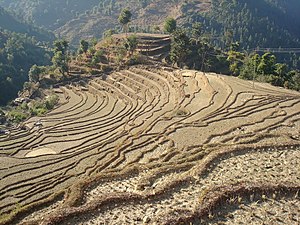 Terraced farmland in Nepal.
The Hill region constitutes the largest portion of
Nepal
, covering 29.5% of the geographical area, and has a large area (19,783 km
2
) of cultivated or managed lands, natural and semi natural vegetation (22,621 km
2
) and artificial surfaces (200 km
2
). The Tarai region has more cultivated or managed land (14,104 km
2
) and comparatively less natural and semi natural vegetation (4280 km
2
). The Tarai has only 267 km
2
of natural water bodies. The High mountain region has 12,062 km
2
of natural water bodies, snow/glaciers and 13,105 km
2
barren areas.
Forests
25.4% of Nepal's land area, or about 36,360 km
2
(14,039 sq mi) is covered with forest according to
FAO
figures from 2005. FAO estimates that around 9.6% of Nepal's forest cover consists of
primary forest
which is relatively intact. About 12.1% Nepal's forest is classified as
protected
while about 21.4% is
conserved
according to FAO. About 5.1% Nepal's forests are classified as
production forest
. Between 2000 and 2005, Nepal lost about 2,640 km
2
(1,019 sq mi) of forest. Nepal's 2000?2005 total deforestation rate was about 1.4% per year meaning it lost an average of 530 km
2
(205 sq mi) of forest annually. Nepal's total deforestation rate from 1990 to 2000 was 920 km
2
(355 sq mi) or 2.1% per year. The 2000?2005 true deforestation rate in Nepal, defined as the loss of primary forest, is ?0.4% or 70 km
2
(27 sq mi) per year. Forest is not changing in the plan land of Nepal, forest fragmenting on the "Roof of the World".
[25]
According to
ICIMOD
figures from 2010, forest is the dominant form of land cover in Nepal covering 57,538 km
2
with a contribution of 39.09% to the total geographical area of the country.
[26]
Most of this forest cover is broadleaved closed and open forest, which covers 21,200 km
2
or 14.4% of the geographical area. Needleleaved open forest is the least common of the forest areas covering 8,267 km
2
(5.62%). At national level 64.8% area is covered by core forests of > 500 ha size and 23.8% forests belong to patch and edge category forests. The patch forest constituted 748 km
2
at national level, out of which 494 km
2
of patch forests are present in hill regions. Middle mountains, Siwaliks and Terai regions have more than 70% of the forest area under core forest category > 500 ha size. The edge forests constituted around 30% of forest area of High Mountain and Hill regions.
[26]
Forest Resource Assessment (FRA) which was conducted between 2010 and 2014 by the Ministry of Forest and Soil conservation with the financial and technical help of the Government of Finland shows that 40.36% of the land of Nepal is forested. 4.40% of the land has shrubs and bushes.
Deforestation is driven by multiple processes.
[27]
Virtually throughout the nation, over-harvest of
firewood
remains problematic. Despite the availability of
liquefied petroleum gas
in towns and cities, firewood is sold more at energy-competitive prices because cutting and selling it is a fallback when better employment opportunities aren't forthcoming. Firewood still supplies 80% of Nepal's energy for heating and cooking. Harvesting construction timber and lopping branches for fodder for cattle and other farm animals are also deforestation/degradation drivers in all geographic zones.
Illegal logging
is a problem in the Siwaliks, with sawlogs smuggled into India.
[28]
Clearing for resettlement and agriculture expansion also causes deforestation as does urban expansion, building infrastructure such as schools, hospitals, electric transmission lines, water tanks, police and army barracks, temples and picnic areas.
In the Middle Hills road construction, reservoirs, transmission lines and extractive manufacturing such as cement factories cause deforestation. In the mountains building hotels, monasteries and trekking trails cause deforestation while timber-smuggling into the
Tibet Autonomous Region
and over-grazing cause degradation.
Boundaries
- Total: 2,926 km
- Border countries:
China
1,236 km,
India
1,690 km
Border crossings with India
While India and Nepal have an open border with no restrictions on movement of their citizens on either side, there are 23
checkpoints
for trade purposes. These are listed in clockwise order, east to west. The six in
italics
are also used for entry/exit by third country nationals.
[29]
Border crossings with China
Ports of Entry According to 2012 Treaty
[30]
Crossing Name
[30]
(Other Name)
|
Nepali Jurisdiction
|
Chinese Jurisdiction
|
Status
|
Crossing
Location
|
Border
elevation
|
Burang?
Yari
(Xieerwa
[31]
)
|
Hilsa
,
Humla District
|
Burang
,
Burang County
|
Active
|
30°09′12″N
81°20′00″E
/
30.15333°N 81.33333°E
/
30.15333; 81.33333
|
3,640 m (11,900 ft)
|
Lizi
?Nechung
(
Kora La
)
|
Lo Manthang
,
Mustang District
|
Zhongba County
|
Planned
|
29°19′24″N
83°59′09″E
/
29.32333°N 83.98583°E
/
29.32333; 83.98583
|
4,620 m (15,200 ft)
|
| Gyirong?Rasuwa
|
Rasuwa Gadhi
,
Rasuwa District
|
Gyirong
,
Gyirong County
|
Active
|
28°16′45″N
85°22′43″E
/
28.27917°N 85.37861°E
/
28.27917; 85.37861
|
1,850 m (6,100 ft)
|
| Zhangmu?
Kodari
|
Tatopani
,
Sindhupalchok District
|
Zhangmu
,
Nyalam County
|
Active
[32]
|
27°58′24″N
85°57′50″E
/
27.97333°N 85.96389°E
/
27.97333; 85.96389
|
1,760 m (5,800 ft)
|
| Chentang?Kimathanka
|
Kimathanka
,
Sankhuwasabha District
|
Chentang
,
Dinggye County
|
Planned
|
27°51′30″N
87°25′30″E
/
27.85833°N 87.42500°E
/
27.85833; 87.42500
|
2,248 m (7,400 ft)
|
Ri'og?Olangchung Gola
(
Tipta La
)
|
Olangchung Gola
,
Taplejung District
|
Ri'og
,
Dinggye County
|
Planned
|
27°49′00″N
87°44′00″E
/
27.81667°N 87.73333°E
/
27.81667; 87.73333
|
5,095 m (16,700 ft)
|
See also
References
- ^
"Government unveils new political map including Kalapani, Lipulekh and Limpiyadhura inside Nepal borders"
.
kathmandupost.com
.
Archived
from the original on 7 January 2024
. Retrieved
20 May
2020
.
- ^
"Nepal's holy Bagmati River choked with black sewage, trash"
.
Associated Press
. 17 August 2022.
Archived
from the original on 12 July 2023
. Retrieved
12 July
2023
.
- ^
"One more report ranks Nepal among most polluted countries in the world"
.
Archived
from the original on 8 July 2023
. Retrieved
8 July
2023
.
- ^
"Accra, Ghana"
.
Archived
from the original on 8 July 2023
. Retrieved
8 July
2023
.
- ^
"Averting an air pollution disaster in South Asia"
. 21 April 2023.
Archived
from the original on 8 July 2023
. Retrieved
8 July
2023
.
- ^
"Trash and Overcrowding at the Top of the World"
.
Archived
from the original on 8 July 2023
. Retrieved
8 July
2023
.
- ^
"The very air we breathe | UNICEF Nepal"
.
Archived
from the original on 8 July 2023
. Retrieved
8 July
2023
.
- ^
Dahal
[
permanent dead link
]
- ^
"Peaks of Nepal"
. Travel Guide. Himalayan Echo Trek and Travel. Archived from
the original
on 7 June 2019
. Retrieved
13 December
2014
.
- ^
Graafen, Rainer; Seeber, Christian (June 1992).
Important Trade Routes in Nepal and Their Importance to the Settlement Process
(PDF)
. Vol. 130.
Archived
(PDF)
from the original on 18 April 2021
. Retrieved
22 September
2020
.
- ^
The Map of Potential Vegetation of Nepal - a forestry/agroecological/biodiversity classification system
(PDF)
, Forest & Landscape Development and Environment Series 2-2005 and CFC-TIS Document Series No.110., 2005,
ISBN
87-7903-210-9
, archived from
the original
(PDF)
on 3 December 2013
, retrieved
22 November
2013
- ^
Mallapaty, Smriti (12 April 2019).
"Nepali scientists record country's first tornado: The team confirmed the rare event using satellite images, social-media posts and a visit to the affected area"
.
Nature News
. Spring Nature Publishing.
Archived
from the original on 17 April 2019
. Retrieved
21 April
2019
.
- ^
Aryal, Ravi Sharma; Rajkarnikar, Gautam (2011).
Water Resources of Nepal in the Context of Climate Change
(PDF)
. Kathmandu: Government of Nepal, Water and Energy Commission Secretariat. p. vii. Archived from
the original
(PDF)
on 3 January 2016
. Retrieved
9 December
2013
.
- ^
Hack, John T. (1960).
"Interpretation of Erosional Topography in Humid Temperate Regions"
(PDF)
.
American Journal of Science
. 258-A: 80?97.
Archived
(PDF)
from the original on 17 April 2012
. Retrieved
10 December
2013
.
- ^
Devkota, Lochan; Crosato, Alessandra; Giri, Sanjay (2012).
"Effect of the barrage and embankments on flooding and channel avulsion, case study Koshi River, Nepal"
.
Rural Infrastructure
.
3
(3): 124?132
. Retrieved
9 December
2013
.
- ^
Thakur, Atul Kumar (7 May 2009).
"Floods of Mithila Region: Raising Questions on Survival"
.
Standpoint
.
Archived
from the original on 18 December 2013
. Retrieved
9 December
2013
.
- ^
Brown, Lester R. (29 November 2013).
"India's dangerous 'food bubble'
"
.
Los Angeles Times
. Archived from
the original
on 18 December 2013
. Retrieved
10 December
2013
.
Alt URL
Archived
16 July 2014 at the
Wayback Machine
- ^
The United Nations. World Food Programme (2009).
Food Security Atlas of Rural Bihar
(PDF)
. New Delhi: Institute for Human Development.
Archived
(PDF)
from the original on 14 December 2013
. Retrieved
11 December
2013
.
- ^
Kennedy, Kristian A. (17 May 2010).
"The Naxalite Insurgency in India"
.
Geopolitical Monitor
.
Archived
from the original on 15 December 2013
. Retrieved
11 December
2013
.
- ^
a
b
Malhotra, Pia (July 2010).
"Water Issues between Nepal, India & Bangladesh, a Review of Literature"
(PDF)
.
IPCS Special Report No. 95
. New Delhi: Institute of Peace and Conflict Studies: 11.
Archived
(PDF)
from the original on 26 November 2013
. Retrieved
11 December
2013
.
- ^
Thapa, A.B. (January 2010).
"Revision of the West Seti Dam Design in Nepal"
.
Hydro Nepal
(6). Kathmandu.
Archived
from the original on 14 December 2013
. Retrieved
11 December
2013
.
- ^
ICIMOD (2011).
"Glacial Lakes and Glacial Lake Outburst Floods in Nepal"
(PDF)
. Kathmandu: International Center for Integrated Mountain Development. Archived from
the original
(PDF)
on 24 January 2014
. Retrieved
11 December
2013
.
- ^
Choden, Sonam (2009).
"Sediment Transport Studies in Punatsangchu River, Bhutan"
. Lund, Sweden: Lund University, Water Resources Engineering.
Archived
from the original on 15 December 2013
. Retrieved
11 December
2013
.
- ^
Uddin, Kabir; Shrestha, Him Lal; Murthy, M. S. R.; Bajracharya, Birendra; Shrestha, Basanta; Gilani, Hammad; Pradhan, Sudip; Dangol, Bikash (15 January 2015). "Development of 2010 national land cover database for the Nepal".
Journal of Environmental Management
. Land Cover/Land Use Change (LC/LUC) and Environmental Impacts in South Asia.
148
: 82?90.
doi
:
10.1016/j.jenvman.2014.07.047
.
PMID
25181944
.
- ^
Uddin, Kabir; Chaudhary, Sunita; Chettri, Nakul; Kotru, Rajan; Murthy, Manchiraju; Chaudhary, Ram Prasad; Ning, Wu; Shrestha, Sahas Man; Gautam, Shree Krishna (September 2015).
"The changing land cover and fragmenting forest on the Roof of the World: A case study in Nepal's Kailash Sacred Landscape"
.
Landscape and Urban Planning
.
141
: 1?10.
doi
:
10.1016/j.landurbplan.2015.04.003
.
- ^
a
b
Uddin, Kabir; Shrestha, Him Lal; Murthy, M. S. R.; Bajracharya, Birendra; Shrestha, Basanta; Gilani, Hammad; Pradhan, Sudip; Dangol, Bikash (15 January 2015). "Development of 2010 national land cover database for the Nepal".
Journal of Environmental Management
. Land Cover/Land Use Change (LC/LUC) and Environmental Impacts in South Asia.
148
: 82?90.
doi
:
10.1016/j.jenvman.2014.07.047
.
PMID
25181944
.
- ^
Kathmandu Forestry College (2013).
Chitwan-Annapurna Landscape Drivers of Deforestation and Forest Degradation
(PDF)
. Kathmandu: World Wildlife Fund Nepal, Hariyo Ban Program.
Archived
(PDF)
from the original on 5 March 2016
. Retrieved
11 December
2013
.
- ^
Khadka, Navin Singh (28 September 2010).
"Nepal's forests 'being stripped by Indian timber demand'
"
. London: British Broadcasting Corporation.
Archived
from the original on 13 October 2018
. Retrieved
11 December
2013
.
- ^
"Nepal-India Open Border: Prospects, Problems and Challenges"
. Nepal Democracy. Archived from
the original
on 18 October 2005
. Retrieved
2 January
2012
.
- ^
a
b
"中?人民共和?政府和尼泊?政府?于?境口岸及其管理制度的?定"
[China-Nepal Agreement on Port of Entry] (in Chinese). Chinese Embassy in Nepal. 14 January 2012.
Archived
from the original on 19 October 2020
. Retrieved
10 February
2017
.
- ^
"News from China"
(PDF)
.
Chinese Embassy in India
. Vol. XXVIII, no. 7. July 2016.
Archived
(PDF)
from the original on 13 July 2019
. Retrieved
15 February
2017
.
- ^
"Kodari Checkpoint To Open Today"
.
The Spotlight Online
. 29 May 2019.
Archived
from the original on 19 October 2020
. Retrieved
28 June
2019
.
External links
|
|---|
| Mountains
| |
|---|
| Plateaus
| |
|---|
| Deserts
| |
|---|
| Lowlands
| |
|---|
| Coasts
| |
|---|
| Islands
| |
|---|
| By country
| |
|---|
| By
region
| |
|---|