From Wikipedia, the free encyclopedia
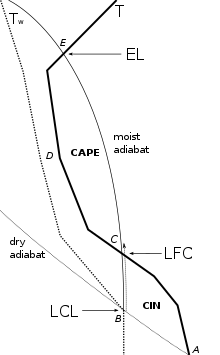 Diagram showing an air parcel path when raised along B-C-E compared to the surrounding air mass Temperature (T) and humidity (Tw)
In
atmospheric sciences
, the
free convective layer
(
FCL
) is the layer of conditional or
potential instability
in the
troposphere
. It is a layer in which rising air can experience positive
buoyancy
(PBE) so that deep, moist convection (DMC) can occur. On an
atmospheric sounding
, it is the layer between the
level of free convection
(LFC) and the
equilibrium level
(EL). The FCL is important to a variety of convective processes and to severe thunderstorm forecasting.
It is the layer of instability, the "positive area" on
thermodynamic diagrams
where an ascending
air parcel
is warmer than its environment.
Integrating
buoyant energy from the LFC to the EL gives the amount of
convective available potential energy
(CAPE), an estimate of the maximum energy available to
convection
. The depth of the FCL is expressed by the formula:
- FCL = Z
EL
- Z
LFC
or
- FCL = P
EL
- P
LFC
Deep, moist convection is essentially a
thunderstorm
or thundercloud, although some such convection does not produce lightning and thus not thunder. It is
cumulus congestus clouds
or
cumulonimbus clouds
. An air parcel ascending from the near surface layer (
mixed layer
(ML) or
boundary layer
(PBL)) must
work
through the stable layer of
convective inhibition
(CIN) when present. This work comes from sufficiently increasing instability in the low levels by raising the
temperature
or
dew point
, or by mechanical lift. Without the aid of mechanical forcing, a parcel must reach its
convective temperature
(T
c
) before moist convection (
cloud
) begins near the
convective condensation level
(CCL), whereas with dynamic lift,
cloud base
begins near the
lifted condensation level
(LCL). When such a
capping inversion
is present, this will remain as shallow, moist convection (small
cumulus clouds
) until breaking through the convective inhibition layer, after which DMC ensues as a parcel hits the LFC and enters the FCL, if thermal or mechanical forcing continues (and sufficient moisture is available in the
inflow
layer). At the level of neutral buoyancy (the EL), a parcel is cooler than the environment and is thermodynamically stable, continuing to rise via
momentum
and thus it slows down until eventually ceasing ascent at the
maximum parcel level
(MPL) --which may visually manifest itself as an
overshooting top
. Ignoring other influences, higher amount of total CAPE in the FCL, and especially greater thickness of this positive area, which can be measured as
lifted index
(LI) at a respective altitude, results in more vigorous
updrafts
and faster air parcel ascent.
See also
[
edit
]
References
[
edit
]
- Blanchard, David O. (Sep 1998). Assessing the Vertical Distribution of Convective Available Potential Energy.
Weather and Forecasting
, 13 (3): 870?877.
External links
[
edit
]
