Archipelago in the Arctic
This article is about the archipelago in Arctic Russia. For the Albanian island, see
Franc Jozeph Island
.
Franz Josef Land
[a]
(
Russian
:
Земля? Фра?нца-Ио?сифа
,
romanized
:
Zemlya Frantsa-Iosifa
;
Norwegian
:
Fridtjof Nansen Land
) is a Russian
archipelago
in the
Arctic Ocean
. It is inhabited only by military personnel.
[1]
It constitutes the northernmost part of
Arkhangelsk Oblast
and consists of 192 islands, which cover an area of 16,134 square kilometers (6,229 sq mi), stretching 375 kilometers (233 mi) from east to west and 234 kilometers (145 mi) from north to south. The islands are categorized in three groups (western, central, and eastern) separated by the
British Channel
and the
Austrian Strait
. The central group is further divided into a northern and southern section by the
Markham Sound
. The largest island is
Prince George Land
, which measures 2,741 square kilometers (1,058 sq mi), followed by
Wilczek Land
,
Graham Bell Island
and
Alexandra Land
.
Approximately 85% of the archipelago is
glaciated
, with large unglaciated areas on the largest islands and many of the smallest ones. The islands have a combined coastline of 4,425 kilometers (2,750 mi). Compared to other Arctic archipelagos, Franz Josef Land is highly dissected, as a result of its being heavy glaciated, with a very low ratio of total area to coastline of just ~3.6 square kilometers per coastline kilometer.
Cape Fligely
on
Rudolf Island
is the northernmost point of the
Eastern Hemisphere
. The highest elevations are found in the eastern group, with the highest point located on Wiener Neustadt Land, 670 meters (2,200 ft)
above mean sea level
.
The archipelago was first spotted by the Norwegian sailors
Nils Fredrik Rønnbeck
and Johan Petter Aidijarvi in 1865, although they did not report their finding. The first reported finding was in the 1873
Austro-Hungarian North Pole expedition
led by
Julius von Payer
and
Karl Weyprecht
, who named the area after Emperor
Franz Joseph I
.
In 1926, the
Soviet Union
annexed the islands, which were known at the time as
Fridtjof Nansen Land
, and settled small outposts for research and military purposes. The
Kingdom of Norway
rejected the claim and several private expeditions were sent to the islands. With the
Cold War
, the islands became off limits for foreigners and two military airfields were built. The islands have been a nature sanctuary since 1994 and became part of the
Russian Arctic National Park
in 2012.
History
[
edit
]
 Austro-Hungarian North Pole Expedition
There are two candidates for the discovery of Franz Josef Land. The first was the Norwegian sealing vessel
Spidsbergen
, with captain
Nils Fredrik Rønnbeck
and harpooner Johan Petter Aidijarvi. They sailed northeast from
Svalbard
in 1865 searching for suitable sealing sites, and they found land that was most likely Franz Josef Land. The account is believed to be factual, but an announcement of the discovery was never made, and their sighting therefore remained unknown to subsequent explorers. It was at the time common to keep newly discovered areas secret, as their discovery was aimed at exploiting them for sealing and whaling, and exposure would cause competitors to flock to the site.
[2]
Russian scientist N. G. Schilling proposed in 1865 that the ice conditions in the Barents Sea could only be explained if there was another land mass in the area, but he never received funding for an expedition.
[3]
The
Austro-Hungarian North Pole Expedition
of 1872?74 was the first to announce the discovery of the islands. Led by
Julius von Payer
and
Karl Weyprecht
of
Austria-Hungary
on board the
schooner
Tegetthoff
, the expedition's primary goal was to find the
Northeast Passage
and its secondary goal to reach the
North Pole
.
[4]
Starting in July 1872,
[5]
the vessel drifted from
Novaya Zemlya
to a new landmass,
[6]
which they named in honor of
Franz Joseph I
(1830?1916),
Emperor of Austria
.
[7]
The expedition contributed significantly to the mapping and exploration of the islands. The next expedition to spot the archipelago was the Dutch Expedition for the Exploration of the Barents Sea, on board the schooner
Willem Barents
. Constrained by the ice, they never reached land.
[8]
Polar exploration
[
edit
]
Benjamin Leigh Smith
's expedition in 1880, aboard the
barque
Eira
, followed a route from
Spitsbergen
to Franz Josef Land,
[8]
landing on
Bell Island
in August. Leigh Smith explored the vicinity and set up a base at Eira Harbour, before exploring towards
McClintock Island
. He returned the following year in the same vessel, landing at Grey Bay on George Land.
[9]
The explorers were stopped by ice at
Cape Flora
, and
Eira
sank on 21 August. They built a cottage and stayed the winter,
[10]
to be rescued by the British vessels
Kara
and
Hope
the following summer.
[11]
These early expeditions concentrated their explorations on the southern and central parts of the archipelago.
[12]
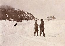 The Nansen?Jackson meeting at
Cape Flora
, 17 June 1896 (a posed photograph taken hours after the initial meeting)
The Nansen?Jackson meeting at
Cape Flora
, 17 June 1896 (a posed photograph taken hours after the initial meeting)
Nansen's
Fram
expedition
was an 1893?1896 attempt by the Norwegian explorer
Fridtjof Nansen
to reach the geographical North Pole by harnessing the natural east?west current of the
Arctic Ocean
. Departing in 1893,
Fram
drifted from the
New Siberian Islands
for one and a half years before Nansen became impatient and set out to reach the North Pole on skis with
Hjalmar Johansen
. Eventually, they gave up on reaching the pole and instead found their way to Franz Josef Land, the nearest land known to man. They were thus able to establish that there was no large landmass north of this archipelago.
[13]
In the meantime the
Jackson?Harmsworth Expedition
set off in 1894, set up a base on
Bell Island
, and stayed for the winter.
[12]
The following season they spent exploring.
[14]
By pure chance, at
Cape Flora
in the spring of 1896, Nansen stumbled upon
Frederick George Jackson
, who was able to transport him back to Norway.
[15]
Nansen and Jackson explored the northern, eastern, and western portions of the islands.
[12]
Once the basic geography of Franz Josef Land had become apparent, expeditions shifted to using the archipelago as a basis to reach the North Pole. The first such attempt was conducted by the
National Geographic Society
-sponsored American journalist
Walter Wellman
in 1898.
[15]
The two Norwegians, Paul Bjørvig and Bernt Bentsen, stayed the winter 1898?9 at
Cape Heller
on
Wilczek Land
, but insufficient fuel caused the latter to die.
[16]
Wellman returned the following year, but the polar expedition itself was quickly abandoned when they lost most of their equipment.
[17]
Italian nobleman
Luigi Amedeo
organized the next expedition in 1899, on the
Stella Polare
.
[18]
They stayed the winter,
[19]
and in February and again in March 1900 set out towards the pole, but failed to get far.
[20]
 The
Stella Polare
was trapped and threatened to sink. The crew were obliged to land with the utmost haste and to secure materials for building a dwelling.
The
Stella Polare
was trapped and threatened to sink. The crew were obliged to land with the utmost haste and to secure materials for building a dwelling.
Evelyn Baldwin
, sponsored by
William Ziegler
, organized the
Ziegler Polar Expedition
of 1901. Setting up a base on
Alger Island
, he stayed the winter exploring the area, but failed to press northwards. The expedition was largely regarded as an utter failure by the exploration and scientific community, which cited the lack of proper management. Unhappy with the outcome, Ziegler organized a new expedition, for which he appointed
Anthony Fiala
, second-in-command in the first expedition, as leader.
[21]
It arrived in 1903 and spent the winter. Their ship,
America
, was crushed beyond repair in December and disappeared in January. Still, they made two attempts towards the pole, both of which were quickly abandoned.
[22]
They were forced to stay another year, making yet another unsuccessful attempt at the pole, before being evacuated in 1905 by the
Terra Nova
.
[23]
The first Russian expedition was carried out in 1901, when the icebreaker
Yermak
traveled to the islands.
[24]
The next expedition, led by hydrologist
Georgy Sedov
, embarked in 1912 but did not reach the archipelago until the following year because of ice. Among its scientific contributions were the first snow measurements of the archipelago, and the determination that changes of the
magnetic field
occur in cycles of fifteen years.
[25]
It also conducted topographical surveys of the surrounding area.
[26]
Scurvy set in during the second winter, killing a machinist. Despite lacking prior experience or sufficient provisions, Sedov insisted on pressing forward with a march to the pole. His condition deteriorated and he died on 6 March.
[27]
 America
anchored at Tepliz Bay
America
anchored at Tepliz Bay
Hertha
was sent to explore the area, and its captain, I. I. Islyamov hoisted a
Russian iron flag
at Cape Flora and proclaimed Russian sovereignty over the archipelago. The act was motivated by the ongoing
First World War
and Russian fears of the
Central Powers
establishing themselves there. The world's first Arctic flight took place in August 1914, when Polish aviator (one of the first pilots of the Russian Navy)
Jan Nagorski
overflew Franz Josef Land in search of Sedov's group.
Andromeda
set out for the same purpose; while failing to locate them, the crew were able to finally determine the non-existence of Peterman Land and King Oscar Land, suspected lands north of the islands.
[28]
The Soviet Union
[
edit
]
Soviet expeditions were sent almost yearly from 1923.
[28]
Franz Josef Land had been considered
terra nullius
? land belonging to no one ? but on 15 April 1926 the Soviet Union declared its
annexation
of the archipelago. Emulating Canada's declaration of the sector principle, they pronounced all land between the Soviet mainland and the North Pole to be Soviet territory. This principle has never been internationally recognized.
[29]
Both Italy and Norway protested.
[28]
Norway was first and foremost concerned about its economic interests in the area, in a period when Norwegian hunters and whalers were also being barred from the
White Sea
, Novaya Zemlya and Greenland; the Soviet government, however, largely remained passive, and did not evict Norwegian hunting ships during the following years. Nor did the Soviets interfere when, in 1928, several foreign ships entered the waters in search of the vanished
airship
Italia
.
[29]
Norway attempted both a diplomatic solution and a
Lars Christensen
-financed expedition to establish a weather station to gain economic control over the islands, but both failed in 1929.
[30]
Instead the Soviet icebreaker
Sedov
set out, led by
Otto Schmidt
, landed in
Tikhaya Bay
, and began construction of a permanent base.
[31]
The Soviet government proposed renaming the archipelago Fridtjof Nansen Land in 1930, but the name never came into use.
[30]
In 1930 the Norwegian
Bratvaag Expedition
visited the archipelago, but was asked by Soviet authorities to respect Soviet territorial water in the future. Other expeditions that year were the Norwegian-Swedish balloon expedition led by
Hans Wilhelmsson Ahlmann
on
Quest
and the German airship
Graf Zeppelin
.
[32]
Except for a
German weather station
emplaced during the
Second World War
, these were the last Western expeditions to Franz Josef Land until 1990.
[33]
Soviet activities grew rapidly following the
International Polar Year
in 1932. The archipelago was circumnavigated, people landed on Victoria Island, and a
topographical map
was completed. In 1934?35 geological and glaciological expeditions were carried out, cartographic flights were flown, and up to sixty people stayed the winters between 1934 and 1936, which also saw the first birth. The first
drifting ice station
was set up out of Rudolf Island in 1936.
[34]
An
airstrip
was then constructed on a glacier on the island, and by 1937 the winter population hit 300.
[35]
Activity dwindled during the
Second World War
and only a small group of men were kept at Rudolf Island, remaining unsupplied throughout the war.
[36]
They never discovered Nazi Germany's establishment of a weather station, named
Schatzgraber
, on
Alexandra Land
as part of the
North Atlantic weather war
. The German station was evacuated in 1944 after the men were struck by
trichinosis
from eating
polar bear
meat.
[37]
Apparent physical evidence of the base was discovered in 2016.
[38]
The
Cold War
produced renewed Soviet interest in the islands because of their strategic military significance. The islands were regarded as an "unsinkable aircraft carrier". The site of the former German weather station was selected as the location of a Soviet aerodrome and military base,
Nagurskoye
. With the advent of
intercontinental ballistic missiles
, the Soviet Union changed its military strategy in 1956, abolishing the strategic need for an airbase on the archipelago. The
International Geophysical Year
of 1957 and 1958 gave a new rise to the scientific interest in the archipelago and an airstrip was built on Heiss Island in 1956. The following year the geophysical
Ernst Krenkel Observatory
was established there.
[36]
Activity at Tikhaya Bay was closed in 1959.
[39]
Because of the islands' military significance, the Soviet Union closed off the area to foreign researchers, although Soviet researchers carried out various expeditions, including in geophysics, studies of the
ionosphere
, marine biology, botany, ornithology, and glaciology.
[40]
The Soviet Union opened up the archipelago for international activities from 1990, with foreigners having fairly straightforward access.
[41]
Recent history
[
edit
]
 Nagurskoye
is Russia's northernmost military base
Nagurskoye
is Russia's northernmost military base
As part of the opening up of Franz Josef Land, the Institute of Geography in Moscow, Stockholm University and Umea University (Sweden) conducted expeditions to Alexandra Land in August 1990 and August 1991, studying climate- and glacial history by radiocarbon dating raised beaches and antlers from extinct caribou.
[42]
[43]
[44]
The work was conducted from a small research base southwest of Nagurskoye, built in 1989. Also in 1990, a collaboration between the Academy of Sciences, the Norwegian Polar Institute and the
Polish Academy of Sciences
resulted in the first of several archaeological expeditions organized by the Institute of Culture in Moscow.
[41]
The military base on Graham Bell Island was abandoned in the early 1990s. The military presence at Nagurskoye was reduced to that of a border post, and the number of people stationed at Krenkel Observatory was reduced from 70 to 12.
[45]
The archipelago and the surrounding waters were declared a
nature reserve
in April 1994. The opening of the archipelago also saw the introduction of tourism, most of which takes place on Russian-operated icebreakers.
[46]
In 2011, in a move to better accommodate tourism in the archipelago, the
Russian Arctic National Park
was expanded to include Franz Josef Land.
[47]
However, in August 2019, Russia abruptly withdrew its approval for a Norwegian cruise ship to visit the islands.
[48]
In 2012, the
Russian Air Force
decided to reopen the
Graham Bell Airfield
as part of a series of reopenings of air bases in the Arctic.
[49]
A major new base, named the
Arctic Trefoil
for its three lobed structure, was constructed at
Nagurskoye
. It can maintain 150 soldiers for 18 months and has an area of 14,000 square meters.
[50]
The upgraded airbase is considered a threat to the U.S. military installation at
Thule, Greenland
.
[51]
In 2017, Russian president
Vladimir Putin
visited the archipelago.
[52]
In August 2019, a geographic expedition by
Russian Northern Fleet
discovered several new islands in the archipelago. They were previously buried under
Vylki
Glacier until part of it melted.
[53]
In April 2020, the archipelago was used by the
Russian Airborne Forces
to perform the world's first
high-altitude military parachuting
(HALO)
paradrop
from the lower border of the
Arctic
stratosphere
. The crews of
Il-76
aircraft practiced at the northernmost airfield of the country on the
island
of Franz Josef Land. Not only did the paratroopers endure the partial oxygen of the stratosphere common under the HALO technique; they encountered deep freeze conditions mitigated by military tested oxygen tanks and uniforms. Challenges to the Arctic mission included undirected terrain, in the absence of ground navigation systems. During the end of the mission, the paratroopers spent a day during which they conducted classes on survival in Arctic conditions and built shelters from snow.
[54]
[55]
[56]
Geography
[
edit
]
 Cape Brice, Ziegler Island, Franz Josef Land
The archipelago constitutes the northernmost part of Russia's Arkhangelsk Oblast, located between 79°46′ and 81°52′ north and 44°52′ and 62°25′ east. It is situated 360 kilometers (220 mi) north of
Novaya Zemlya
and 260 kilometers (160 mi) east of the Norwegian archipelago of
Svalbard
.
[57]
Located within the Arctic Ocean, Franz Josef Land constitutes the northeastern border of the Barents Sea and the northwestern border of the Kara Sea.
[
citation needed
]
The islands are 900 kilometers (560 mi) from the
North Pole
and 750 kilometers (470 mi) from the
Yamal Peninsula
, the closest point of the
Eurasian
mainland.
[57]
The archipelago falls within
varying definitions of the Asia?Europe border
, and is therefore variously defined as part of Asia or of Europe. Cape Flighely, situated at 81°50′ north, is the
northernmost point in Eurasia
and the
Eastern Hemisphere
,
[57]
and of either
Europe
or
Asia
, depending on the continental definition.
[
citation needed
]
It is the
third-closest
landmass to the North Pole.
[58]
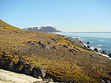
 Bell Island
The archipelago comprises 191 uninhabited islands with a combined area of 16,134 square kilometers (6,229 sq mi). These stretch 375 kilometers (233 mi) from east to west and 234 kilometers (145 mi) from north to south.
[57]
One can categorize the islands into three groups, a western, central and eastern, separated by the British Channel and the Austrian Strait. The central group is further divided into a northern and southern section by
the Markham Strait
. Graham Bell Island is separated from the eastern group by the Severo?Vostochnyi Strait.
[59]
There are two named island clusters:
Zichy Land
north of
Markham Sound
; and
Belaya Zemlya
to the extreme northeast.
[
citation needed
]
The straits are narrow, between several hundred meters to 3 kilometers (2 mi) wide. They reach depths of 500 to 600 meters (1,600 to 2,000 ft), 150 to 300 meters (500 to 1,000 ft) below the shelf of the Barents Sea.
[59]
The largest island is
Prince George Land
, which measures 2,741 square kilometers (1,058 sq mi). Three additional islands exceed 1,000 square kilometers (390 sq mi) in size:
Wilczek Land
,
Graham Bell Island
and
Alexandra Land
. Five more islands exceed 500 square kilometers (190 sq mi):
Hall Island
,
Salisbury Island
,
McClintock Island
,
Jackson Island
and
Hooker Island
. The smallest 135 islands constitute 0.4 percent of the archipelago's area.
[57]
The highest elevation is a peak on Wilczek Land, which rises 670 meters (2,200 ft) above mean sea level.
Victoria Island
, located 170 kilometers (110 mi) to the west of Alexandra Land, is administratively part of the archipelago, but the island is not geographically part of the island group and is closer to Svalbard, located 60 kilometers (37 mi) from
Kvitøya
.
[60]
Geology
[
edit
]
 Cape Tegetthoff on
Hall Island
Cape Tegetthoff on
Hall Island
Geologically the archipelago is located on the northern edge of the Barents Sea Platform, within an area where
Mesozoic
sedimentary
rocks are exposed. The area has four
units
separated by regional
erosion surfaces
. The Upper
Paleozoic
unit is poorly exposed and was created by
folding
during the
Caledonian
period. The Lower Mesozoic unit, consisting of coastal and marine
sediments
from the Upper
Triassic
period, is present on most islands and on the bottom of the straits and consists of
limestones
,
shales
,
sandstones
and
conglomerate
.
The Upper Mesozoic unit dominates in the southern and western parts, consisting of massive
effusive
rocks made up of
basaltic
sheets separated by
volcanic ashes
and
tuffs
, mixed with
terrigenous
rocks with layers of coal.
[61]
The Mesozoic-Tertiary unit remains mostly on the sea floor and consist of marine
quartz
sandstones and shales.
Plate tectonics
of the Arctic Ocean created basalt
lavas
and
dolerite
sheets and
dykes
in the Upper
Jurassic
and Lower
Cretaceous
periods.
[62]
The land is
rising
by 2.5 to 3.0 millimeters (0.098 to 0.118 in) per year, due to the melting of the Barents Sea Ice Sheet c. 10,000 years ago.
[63]
Hydrology
[
edit
]
Franz Josef Land is dominated by glaciation, which covers an area of 13,735 square kilometers (5,303 sq mi), or 85 percent of the archipelago.
[57]
The glaciers have an average thickness of 180 meters (590 ft), which would convert to 2,500 cubic kilometers (600 cu mi). This would alone give a 6 millimeters (0.24 in)
eustatic
rise in
sea level
should it melt.
[64]
Large ice-free areas are only found on the largest islands, such as the 499.8-square-kilometer (193.0 sq mi) Armitage Peninsula of George Land, the 493.7-square-kilometer (190.6 sq mi) Kholmistyi Peninsula of Graham Bell Island, the 270-square-kilometer (100 sq mi) Central'naya Susha of Alexandra Land, the 162.6-square-kilometer (62.8 sq mi) Ganza Point of Wilczek Land and the 84.2-square-kilometer (32.5 sq mi) Heyes Island. Most of the smaller islands are unglaciated.
[57]
 Iceberg at
Heiss Island
in September 2007.
Iceberg at
Heiss Island
in September 2007.
Streams only form during the runoff period from May through early September.
Permafrost
causes most of the runoff to take place on the surface, with streams only forming on the largest islands. The longest river is 19 kilometers (12 mi) long and forms on George Land, while there are several streams on Alexandra Land, the longest being 8.4 kilometers (5.2 mi).
[65]
There are about one thousand lakes in the archipelago, the majority of which are located on Alexandra Land and George Land. Most lakes are located in depressions caused by glacial erosion, in addition to a smaller number of lagoon lakes. Their sizes vary from 2 square kilometers (0.77 sq mi) to 0.4 hectares (0.99 acres). Most are only 2 meters (6 ft 7 in) deep, with the deepest measured at 10 meters (33 ft).
[66]
The sea
currents
surrounding the archipelago touch eastern Svalbard and northern Novaya Zemlya. The cold Makarov Current flows from the north and the Arctic Current flows from the northwest, while the warmer Novaya Zemlya Current flows from the south. The latter has temperatures over 0.5 °C (32.9 °F), while the bottom water lies below ?1.7 °C (28.9 °F). The southern coastal regions of the archipelago experience currents from east to west. Average velocity is between 2 and 5 centimeters (0.79 and 1.97 in) per second. The tidal component in coastal areas is 15 centimeters (5.9 in) per second.
[67]
Pack ice
occurs throughout the year around the entire island group, with the lowest levels being during August and September. One-year winter ice starts forming in October and reaches a thickness of 1.5 meters (4 ft 11 in).
[68]
Icebergs
are common year-round.
[69]
Climate
[
edit
]
 Satellite image of Franz Josef Land from August 2011
Franz Josef Land is in a transition zone between an
ice cap climate
(EF) and a
tundra climate
(ET), technically falling into the latter because July and August average above freezing, nevertheless, low temperatures remain below freezing year round. The main forces influencing the climate are the glaciation and sea ice. At 81° north the archipelago experiences 141 annual days of
midnight sun
, from 12 April to 30 August. During the winter it experiences 128 days of
polar night
from 19 October to 23 February. Abundant cloud cover further cools the climate. The sea starts to freeze in late September and reaches its annual maximum in March, at which time ninety-five percent of the sea is ice-covered. The ice coverage starts to decrease in May and experiences major melting in June, with the minimum occurring in August or early September.
[70]
During winter, high-pressure weather and clear skies cause radiation loss from the ground, sending temperatures down to ?40 °C (?40 °F). During shifts the temperatures can change by 20 °C (36 °F) within hours. Coastal stations experience mean January temperatures of between ?20 °C (?4 °F) and ?30 °C (?22 °F), varying heavily from year to year depending on the degree of cycles in weather patterns. During summer the temperatures are a lot more even and average at between 0 °C (32 °F) and 3 °C (37 °F) at Hayes Island.
[71]
Fog is most common during the summer. Average annual precipitation at the coastal stations is between 100 and 150 millimetres (3.9 and 5.9 in), with the wettest months being from July through September. Elevated areas can experience considerably higher precipitation.
[72]
Franz Josef Land is significantly colder than
Spitsbergen
, which experiences 8 °C (14 °F) warmer winter averages, but is warmer than the
Canadian Arctic Archipelago
.
[73]
| Climate data for
Ernst Krenkel Observatory
,
Heiss Island
|
| Month
|
Jan
|
Feb
|
Mar
|
Apr
|
May
|
Jun
|
Jul
|
Aug
|
Sep
|
Oct
|
Nov
|
Dec
|
Year
|
| Record high °C (°F)
|
1.9
(35.4)
|
0.0
(32.0)
|
1.6
(34.9)
|
0.7
(33.3)
|
2.6
(36.7)
|
8.0
(46.4)
|
10.3
(50.5)
|
8.4
(47.1)
|
5.6
(42.1)
|
3.8
(38.8)
|
1.3
(34.3)
|
1.7
(35.1)
|
10.3
(50.5)
|
| Mean daily maximum °C (°F)
|
?19.2
(?2.6)
|
?19.5
(?3.1)
|
?19.4
(?2.9)
|
?15.6
(3.9)
|
?6.5
(20.3)
|
0.1
(32.2)
|
2.1
(35.8)
|
1.4
(34.5)
|
?1.2
(29.8)
|
?8.1
(17.4)
|
?13.9
(7.0)
|
?18.4
(?1.1)
|
?9.9
(14.2)
|
| Daily mean °C (°F)
|
?22.7
(?8.9)
|
?23.1
(?9.6)
|
?23
(?9)
|
?18.7
(?1.7)
|
?8.7
(16.3)
|
?1.4
(29.5)
|
0.7
(33.3)
|
0.1
(32.2)
|
?2.7
(27.1)
|
?10.4
(13.3)
|
?17.4
(0.7)
|
?21.8
(?7.2)
|
?12.4
(9.7)
|
| Mean daily minimum °C (°F)
|
?26.2
(?15.2)
|
?26.5
(?15.7)
|
?26.5
(?15.7)
|
?21.6
(?6.9)
|
?10.8
(12.6)
|
?2.8
(27.0)
|
?0.3
(31.5)
|
?1.0
(30.2)
|
?4.2
(24.4)
|
?12.9
(8.8)
|
?20.3
(?4.5)
|
?25.1
(?13.2)
|
?14.9
(5.2)
|
| Record low °C (°F)
|
?42.1
(?43.8)
|
?44.4
(?47.9)
|
?43.5
(?46.3)
|
?39.6
(?39.3)
|
?27.7
(?17.9)
|
?12.3
(9.9)
|
?4.3
(24.3)
|
?8.5
(16.7)
|
?23.2
(?9.8)
|
?32.3
(?26.1)
|
?39.5
(?39.1)
|
?41.5
(?42.7)
|
?44.4
(?47.9)
|
| Average
precipitation
mm (inches)
|
32
(1.3)
|
31
(1.2)
|
20
(0.8)
|
15
(0.6)
|
13
(0.5)
|
10
(0.4)
|
18
(0.7)
|
22
(0.9)
|
26
(1.0)
|
21
(0.8)
|
24
(0.9)
|
27
(1.1)
|
259
(10.2)
|
| Average rainy days
|
0.1
|
0.1
|
0
|
0.1
|
0.5
|
3
|
12
|
12
|
6
|
0.5
|
0.1
|
0
|
34
|
| Average snowy days
|
20
|
19
|
19
|
16
|
22
|
15
|
7
|
10
|
18
|
24
|
21
|
19
|
209
|
| Average
relative humidity
(%)
|
83
|
82
|
80
|
81
|
85
|
88
|
91
|
92
|
90
|
86
|
84
|
83
|
85
|
| Source: pogoda.ru.net
[74]
|
Nature
[
edit
]
 Arctic poppy
on
Heiss Island
Arctic poppy
on
Heiss Island
The climate and permafrost limits soil development in the archipelago. Large areas are devoid of soil, with permafrost polygons being the most common site for soil to occur. The soil typically has incomplete
soil profiles
and polygonal form with rich content of iron and is either neutral or slightly acidic. The brown upper
humus
layers have three percent organic matter, increasing to eight percent in the southernmost islands.
[75]
Arctic desert soils occur on the eastern group islands, while the areas near the edge of the glaciers have bog-like arctic soil.
[76]
The
flora
varies between islands, based on the natural conditions. On some islands,
vegetation
is limited to
lichen
growing on stones.
[77]
Vegetation typically covers five to ten percent of the ground surface, with notable exceptions under bird colonies where it can reach one hundred percent. Vegetation varies with the altitude: up to 120 to 130 meters (390 to 430 ft) there is a belt of grass-moss arctic desert, then moss-lichen arctic desert to 175 to 200 meters (574 to 656 ft), then lichen arctic desert up to 250 to 315 meters (820 to 1,033 ft) and above lifeless snow desert, with occasional lichens on
nunataks
and
snow algae
on glacier surfaces.
[78]
 Northbrook Island
Trees, shrubs and tall plants cannot survive. About 150 species of
bryophytes
dominate the grassy turf, of which two-thirds are
mosses
and a third
liverworts
. The most common species are
Aulacomnium
,
Ditrichum
,
Drepanocladus
,
Orthothecium
and
Tomenthypnum
. More than 100 species of lichen are found on the island, the most common being
Caloplaca
,
Lecanora
,
Lecidea
,
Ochrolechia
and
Rinodina
.
[78]
There are sixteen species of
grass
and about 100 species of
algae
, most commonly
Cyanophyta
and
Diatomea
.
[79]
Fifty-seven species of
vascular plants
have been reported. The most common are
Arctic poppy
and
saxifraga
, which grow everywhere, independent of habitat, with the latter's nine species being found on all islands. Common plants in wet areas are
Alopecurus magellanicus
(alpine meadow-
foxtail grass
),
buttercups
[80]
and
polar willow
.
Alopecurus magellanicus
and
Papaver dahlianum
are the tallest plants, able to reach heights of 30 centimeters (12 in).
[79]
More than one hundred
taxa
of single-cell
pelagic
algae
have been identified around the archipelago, the most common being
Thalassiosira antarctica
and
Chaetoceros decipiens
. The bloom takes place between May and August.
[81]
Of the roughly fifty species of
zooplankton
,
calanoids
dominate, with
Calanus glacialis
and
Calanus hyperboreus
constituting the greater portion of the biomass. On the sea bottom there are 34 species of
macroalgae
and at least 500 species of
macrofauna
. Most common are
crustaceans
such as
amphipods
and
shrimps
,
polychaetes
and
echinoderms
, such as
sea bristles
.
[82]
The ice scouring causes there to be little life in the
littoral zone
, but the
sublittoral
zone (2 to 25 meters (6 ft 7 in to 82 ft 0 in)) is dominated by
laminaria
, most commonly
Laminaria sachcharina
, and
red algae
, such as
Phycodrys rubens
.
[83]
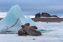 Walrus
on
Heiss Island
Walrus
on
Heiss Island
There are 33 species of
fish
in the waters, none of which are abundant or commercially exploitable.
[83]
The most common are
polar cod
, which reach lengths of 20 centimeters (7.9 in), and
liparidae
. There are no
endemic
species within the archipelago.
[84]
Forty-one species of birds have been documented in the archipelago, of which fourteen breed. These are dominated by
seabirds
such as
fulmar
,
kittiwake
,
Brunnich's guillemot
,
black guillemot
and
little auk
are common throughout the archipelago, while seven other species prefer nesting on flat tundra:
common eider
,
purple sandpiper
,
Arctic skua
,
glaucous gull
,
ivory gull
,
Arctic tern
and
snow bunting
.
[85]
Some ivory gulls, little auks and Brunnich's guillemots opt to spend the winter on the islands.
[86]
The
polar bear
population of Franz Josef Land lies within the
Barents Sea
subpopulation, which also includes polar bears inhabiting Svalbard and the western coast of
Novaya Zemlya
.
[87]
In 2004, the Barents Sea subpopulation was estimated at 2,650.
[88]
There is also a population of
Arctic fox
, which typically have their territories near seabird habitats.
[89]
There are no caribou living on Franz Josef Land today. However, radiocarbon dating of shed antlers found on Alexandra Land in 1990 has shown that there was a population of caribou living on the island around 4000 to 2000 years ago.
[44]
It is likely that the population died out when the climate became colder.
Marine mammals
[
edit
]
As a declared marine mammal sanctuary,
[90]
the area around the islands has a rich biodiversity of rare marine mammals.
Three species of
seals
habit the archipelago.
Harp seal
is the most common, although it breeds in the
White Sea
. Slightly less common is the
bearded seal
.
Walruses
were previously hunted, dramatically reducing the formerly abundant species.
[91]
They have been internationally protected since 1952 and their numbers have since been on the rise, with between one and three thousand walruses living in the archipelago. The population is common with Svalbard and northern
Novaya Zemlya
.
Minke whales
,
humpback whale
, and
beluga whales
are commonly seen around the island, and less commonly
orcas
and
narwhales
, with the archipelago being located on the northern edge of their summer range.
Fin whales
were recently confirmed to migrate into the waters.
[92]
Critically endangered cetaceans
[
edit
]
Occasionally there are sightings of
bowhead whale
.
[93]
The Russian Arctic stock of this species, ranging from
Cape Farewell
in
Greenland
and
Svalbard
/
Spitsbergen
areas to
East Siberian Sea
is considered to be the most endangered of all bowhead populations in the world. The waters around Franz Josef Land appear to be the most important place for this stock.
[94]
[95]
Human activity
[
edit
]
 Polar Geophysical Observatory on Heiss Island
Tourism
travel to the archipelago is severely limited. There is no infrastructure to support tourists and the only way to reach the islands is by
icebreaker
, typically operating out of
Murmansk
. In 2012 there were only eight successful landings on the islands. A contributing factor to the low utilization is the difficulty of obtaining permissions and frequent closing of the
Kola Bay
to accommodate military exercises. The most frequent service is a three-week North Pole tour with Russian
nuclear-powered icebreaker
50 Let Pobedy
, which stops by the islands en route.
[96]
The most popular destinations are areas with
bird cliffs
and walrus colonies, such as Cape Flora on
Northbrook Island
and Cape Rubini on
Hooker Island
, as well as historical remains such as Nansen's hut on
Jackson Island
.
[97]
Tourists are commonly landed by helicopter.
[98]
For purposes of
amateur radio
awards the islands count as a separate international "entity". Activity by radio operators has become less frequent, though it does occasionally occur.
[99]
Nagurskoye Air Base
is located on the Northern part of Alexandra Land. It was extensively upgraded in the mid-2010s to support a greater military presence.
[100]
See also
[
edit
]
Notes
[
edit
]
- ^
Name variants:
Frantz Iosef Land
,
Franz Joseph Land
or
Francis Joseph's Land
References
[
edit
]
- ^
Military.com: Russia Touts Arctic Military Base as US Struggles to Catch Up
- ^
Barr (1995): 59 *
Barr, Susan (1995).
Franz Josef Land
. Oslo:
Norwegian Polar Institute
.
ISBN
82-7666-095-9
.
- ^
Barr (1995): 129
- ^
Barr (1995): 107
- ^
Barr (1995): 110
- ^
Barr (1995): 112
- ^
Barr (1995): 119
- ^
a
b
Barr (1995): 61
- ^
Barr (1995): 62
- ^
Barr (1995): 63
- ^
Barr (1995): 64
- ^
a
b
c
Barr (1995): 65
- ^
Barr (1995): 72
- ^
Barr (1995): 66
- ^
a
b
Barr (1995): 76
- ^
Barr (1995): 78
- ^
Barr (1995): 79
- ^
Barr (1995): 80
- ^
Barr (1995): 81
- ^
Barr (1995): 82
- ^
Barr (1995): 88
- ^
Barr (1995): 90
- ^
Barr (1995): 92
- ^
Barr (1995): 130
- ^
Barr (1995): 131
- ^
Barr (1995): 132
- ^
Barr (1995): 133
- ^
a
b
c
Barr (1995): 134
- ^
a
b
Barr (1995): 95
- ^
a
b
Barr (1995): 96
- ^
Barr (1995): 136
- ^
Barr (1995): 98
- ^
Barr (1995): 100
- ^
Barr (1995): 138
- ^
Barr (1995): 139
- ^
a
b
Barr (1995): 141
- ^
Barr (1995): 101
- ^
Russian Scientists Say They've Discovered a Secret Nazi Base in The Arctic
- ^
Barr (1995): 142
- ^
Barr (1995): 144
- ^
a
b
Barr (1995): 104
- ^
Glazovskiy, Andrey; Naslund, Jens-Ove; Zale, Rolf (1992). "Deglaciation and shoreline displacement on Alexandra Land, Franz Josef Land".
Geografiska Annaler
. 74(A) (4): 283?293.
doi
:
10.1080/04353676.1992.11880371
.
- ^
Naslund, Jens-Ove; Zale, Rolf; Glazovskiy, Andrey (1994). "The Mid Holocene transgression on Alexandra Land, Franz Josef Land, Russia".
Geografiska Annaler
. 76(A) (1?2): 97?101.
doi
:
10.1080/04353676.1994.11880409
.
- ^
a
b
Zale, Rolf; Glazovskiy, Andrey; Naslund, Jens-Ove (1994). "Radiocarbon dating the extinct caribou on Franz Josef Land".
Boreas
.
23
(3): 254?258.
doi
:
10.1111/j.1502-3885.1994.tb00947.x
.
- ^
Barr (1995): 151
- ^
Barr (1995): 152
- ^
Sazhenova, Anastasia (29 August 2011).
"Russia ready to boost Arctic tourism"
.
Barents Observer
.
- ^
Thomas, Nilsen (19 August 2019).
"Norwegian cruise ship banned from sailing Franz Josef Land"
.
Barents Observer
.
- ^
Pettersen, Trude (31 May 2012).
"Russia reopens Arctic airbases"
.
Barents Observer
.
- ^
Russia Builds Second Military base to Support Arctic Ambitions
- ^
Cela, Margret, and Pia Hansson. Geopolitics and Neglected Arctic Spaces: Three Northern Perspectives on Balancing External Interests. Center for Strategic and International Studies (CSIS), 2020.
JSTOR website
Retrieved 14 Sept. 2023.
- ^
"Vladimir Putin visits Arctic archipelago and stakes claim to the oil-rich region"
.
The Telegraph
. 30 March 2017.
- ^
Arctic team maps five islands found by Russian student - BBC News
- ^
"Russian paratroopers for the first time in world history made a landing as part of a group on new parachute systems from an altitude of 10,000 meters in Arctic conditions"
.
Ministry of Defence of the Russian Federation
. 26 April 2020
. Retrieved
11 June
2020
.
- ^
Humpert, Malte.
"Russian Paratroopers Perform First-Ever High Altitude Jump Over Arctic"
.
www.highnorthnews.com
. Retrieved
2020-06-11
.
- ^
"ЦАМТО / Новости / Экипажи ВТА обеспечили первое в истории высотное десантирование подразделений ВДВ"
.
armstrade.org
. Retrieved
2020-06-11
.
- ^
a
b
c
d
e
f
g
Barr (1995): 8
- ^
Luck (2008): 182
- ^
a
b
Barr (1995): 9
- ^
"Victoria Island"
.
- ^
Barr (1995): 22
- ^
Barr (1995): 23
- ^
Barr (1995): 26
- ^
Barr (1995): 15
- ^
Barr (1995): 27
- ^
Barr (1995): 28
- ^
Barr (1995): 38
- ^
Barr (1995): 39
- ^
Barr (1995): 40
- ^
Barr (1995): 11
- ^
Barr (1995): 12
- ^
Barr (1995): 14
- ^
Barr (1995): 13
- ^
?
Погода и Климат
. Retrieved 17 November 2012.
- ^
Barr (1995): 30
- ^
Barr (1995): 31
- ^
Barr (1995): 32
- ^
a
b
Barr (1995): 33
- ^
a
b
Barr (1995): 35
- ^
Barr (1995): 34
- ^
Barr (1995): 41
- ^
Barr (1995): 42
- ^
a
b
Barr (1995): 43
- ^
Barr (1995): 44
- ^
Barr (1995): 46
- ^
Barr (1995): 49
- ^
Obbard M., Thiemann G., Peacock E., DeBruyn T. (eds), 2010. Polar Bears: Proceedings of the 15th Working Meeting of the IUCN/SSC Polar Bear Specialist Group.
http://data.iucn.org/dbtw-wpd/edocs/SSC-OP-043.pdf
. Retrieved on 04-01-2015
- ^
Obbard M. et al. (2010).
- ^
Barr (1995): 53
- ^
Nefedova T., Gavrilo M., Gorshkov S., 2013. Летом в Арктике стало меньше льда.
"Летом в Арктике стало меньше льда | Русское географическое общество"
. Archived from
the original
on 2014-05-24
. Retrieved
2014-05-23
.
. Russian Geographical Society. retrieved on 24-05-2014
- ^
Barr (1995): 50
- ^
Sala E., 2013. Franz Josef Land Expedition: First Look at Post-Expedition Discoveries.
[1]
. Pristine Seas Expeditions.
National Geographic
. retrieved on 24-05-2014
- ^
Barr (1995): 51
- ^
ECS, the European Cetacean Society. Bowhead whales (Balaena mysticetus) sighting in the Franz Josef Land area..
"Bowhead whales (Balaena mysticetus) sighting in the Franz Josef Land area. | European Cetacean Society"
. Archived from
the original
on 2014-05-23
. Retrieved
2014-05-23
.
. retrieved on 24-05-2014
- ^
Scalini I., 2014. Всемирный день китов.
"Национальный парк "Русская Арктика"
"
. Archived from
the original
on 2014-11-29
. Retrieved
2014-11-29
.
. Russian Arctic National Park. retrieved on 24-05-2014
- ^
"Travel to Franz Josef Land"
. Archived from
the original
on 2020-02-03
. Retrieved
2014-01-12
.
- ^
Barr (1995): 153
- ^
Barr (1995): 154
- ^
Franz Josef Land May Become a Rare One
- ^
Staalesen, Atle; Observer, The Independent Barents (2018-09-27).
"Russia giving major upgrade to airstrip in High Arctic"
.
Eye on the Arctic
. Retrieved
2021-09-28
.
Bibliography
[
edit
]
- Luigi Amedeo of Savoy:
On the Polar Star in the Arctic Sea
(Dodd, Mead & Co., New York 1903 and Hutchinson & Co., London 1903)
- Barr, Susan (1995).
Franz Josef Land
. Oslo:
Norwegian Polar Institute
.
ISBN
82-7666-095-9
.
- Anthony Fiala:
Fighting the Polar Ice
(Doubleday, Page & Company, New York 1906)
- Gunnar Horn:
Franz Josef Land. Natural History, Discovery, Exploration and Hunting
(Skrifter om Svalbard og Ishavet No. 29. Oslo 1930)* Frederick G. Jackson:
A Thousand Days in the Arctic
(Harper & Brothers Publishers, New York and London 1899)
- Luck, Michael (2008).
The Encyclopedia of Tourism and Recreation in Marine Environments
. CABI.
ISBN
978-1-84593-350-0
.
- Fridtjof Nansen:
Farthest North. Being the Record of a Voyage of Exploration of the Ship FRAM 1893?96
. (Archilbald Constable and Co, Westminster 1897)
- Julius Payer:
New Lands within the Arctic Circle. Narrative of the Discoveries of the Austrian Ship
Tegetthoff
in the Years 1872?74
(D. Appleton, New York 1877)
External links
[
edit
]
|
|---|
| International
| |
|---|
| National
| |
|---|
| Other
| |
|---|