This article is about the fort in Rhode Island. For the Civil War-era fort in the District of Columbia, see
Fort Greble
.
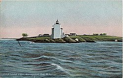 Dutch Island Light
, from an early twentieth century postcard
Dutch Island Light
, from an early twentieth century postcard
Dutch Island
is an island lying west of
Conanicut Island
at an entrance to
Narragansett Bay
in
Rhode Island
, United States. It is part of the town of
Jamestown, Rhode Island
, and has a land area of 0.4156 km² (102.7 acres). It was uninhabited as of the
United States Census, 2000
. The island was fortified from the
American Civil War
through
World War II
and was known as
Fort Greble
from 1898 to 1947.
History
[
edit
]
 Dutch Island in 2008 from
Fort Getty
Dutch Island in 2008 from
Fort Getty
Dutch Island's Indian name was
Quotenis
or
Quetenesse
.
Abraham Pietersen van Deusen
of the
Dutch West India Company
established a trading post on the island around 1636 to trade with the
Narragansett Indians
, trading Dutch goods, cloths, implements, and liquors for the Indians' furs, fish, and venison. Several years later, the Dutch built
Fort Ninigret
in
Charlestown
. In 1654, English colonists purchased the island from the Indians. In 1825, the federal government acquired 6 acres (24,000 m
2
) at the southern end of the island, and
Dutch Island Light
was established on January 1, 1827 to mark the west passage of Narragansett Bay and to aid vessels entering Dutch Island Harbor. The first 30-foot (9.1 m) tower was built of stones found on the island. The government constructed a new 42-foot (13 m) brick tower in 1857 with a fog bell added in 1878. No remnants exist today of the Dutch trading post, but a lighthouse and military buildings remain on the island.
Fort Greble
[
edit
]
 A US coast defense battery with two guns on disappearing carriages, similar to the 10-inch gun battery at Fort Greble
Fort Greble
was named in honor of 1st Lt.
John Trout Greble
, 2nd Artillery, USA, who was the first officer of the
Regular Army
killed in the Civil War. In 1863, the land was sold to the United States government, and the island was taken over by the Army by 1864.
American Civil War
[
edit
]
During the
American Civil War
, the island was used as a training site by the
14th Rhode Island Heavy Artillery (Colored)
. The soldiers of the 14th Rhode Island constructed the first earthwork defenses on the island, and sporadic construction continued after the Civil War ended. An eight-gun battery was built and armed by the 14th Rhode Island in 1863-64. A battery for eleven 10-inch
Rodman guns
was also built at the south end of the island; it extended in a north-south line and had wide arcs of fire on either side. However, it was vulnerable to flooding and was never armed.
[1]
Spanish American War
[
edit
]
More gun batteries were placed on Dutch Island after the Civil War. In 1870, a massive fort was proposed for Dutch Island mounting forty 15-inch Rodman guns, but funding for this was cut off in 1875, and nearly all coast defense funding was cut off nationwide within a few years.
[2]
However, the recommendations of the
Endicott Board
in the late 1890s resulted in the construction of
Fort Greble
as part of the
Coast Defenses of Narragansett Bay
. This was spurred by the
Spanish?American War
and included tunnels and gun emplacements, with the fort enlarged until 1902. The first of Fort Greble's works was Battery Hale, completed in 1897 with the emplacement of three
10-inch M1888
disappearing guns
. A battery was constructed for one
6-inch Armstrong gun
shortly after the war started, but the gun was removed in 1903.
[3]
This was followed by the establishment of Battery Mitchell on the Armstrong gun site with three
6-inch M1903
disappearing guns, and Battery Sedgwick with eight
12-inch M1890 mortars
. Finally Battery Ogden was completed in 1900 with its two
3-inch M1898 rapid fire guns
on retractable masking parapet carriages. The fort also had facilities for controlling an
underwater minefield
, and the mines were stored at
Fort Wetherill
.
[4]
[5]
Battery Hale was named for
Revolutionary War
hero
Nathan Hale
. Battery Mitchell was named for Captain David D. Mitchell, killed in the
Philippine?American War
. Battery Sedgwick was named for Major-General
John Sedgwick
, killed in the Civil War. Battery Ogden was named for Frederick C. Ogden, an officer killed in the Civil War.
[4]
Inter-war period training exercises
[
edit
]
The
New York Times
reported that a combined arms training exercise was conducted on 26 June 1908 involving regular and militia military units from Fort Adams and Fort Greble.
[1]
Soldiers and their commanders launched a simulated land and sea attack on the island, and the residents of Newport and Jamestown were kept awake all night by the sound of the fort's guns.
Corporal William W. Lee loaded two pounds of the wrong powder into Fort Greble's reveille gun on 2 April 1912, which typically used only 4 ounces or 8 tablespoons of black powder, and the breech blew up when he pulled the lanyard. His wounds were fatal, and his grave is located in Jamestown's town cemetery on Narragansett Ave.
[6]
World Wars 1 and 2
[
edit
]
The fort was home to as many as 495 soldiers during
World War I
under the command of Colonel
Charles Foster Tillinghast Sr.
Several of its guns were dismounted for potential service on the
Western Front
in 1917-18. One 10-inch gun of Battery Hale was dismounted for conversion to a
railway gun
; it was replaced by a similar gun from
Fort Wetherill
in late 1918. The three 6-inch guns of Battery Mitchell were dismounted in 1917 and sent to France for use on wheeled carriages; they were not returned to Fort Greble. None of the 6-inch gun regiments completed training before the
Armistice of 11 November 1918
and thus did not see combat.
[4]
[7]
Four of Battery Sedgwick's eight 12-inch mortars were dismounted in 1918 for potential use as railway artillery and to improve reloading efficiency.
[4]
Battery Ogden's 3-inch guns were withdrawn from service in 1920 as part of a general retirement of the M1898 3-inch guns.
[4]
The fort was active till the mid-1920s as part of the
Coast Defenses of Narragansett Bay
. It was placed in caretaker status because the fort's
cisterns
were defective and could not hold sufficient water to support the garrison.
During World War II, Fort Greble was used as a German prisoner-of-war camp and was discontinued from service in 1947. The fort's guns were scrapped in 1942 once improved defenses were constructed centered on
Fort Church
and
Fort Greene
.
[4]
[5]
Since World War 2
[
edit
]
There have been no redevelopment or preservation efforts on Dutch Island since World War 2, and it has been used as a training site for the
Rhode Island National Guard
. The island is owned by the State of Rhode Island and is designated as a wildlife management area by the state's Department of Environmental Management (DEM). In 2016, the
Army Corps of Engineers
completed a project to mitigate safety hazards on the island.
Gallery
[
edit
]
-
12-inch mortar pit at Fort Greble.
-
6-inch disappearing gun at Fort Greble.
-
3-inch gun M1898 on retractable masking parapet carriage M1898, the type that was at Fort Greble
-
Fort Greble from the ferry.
-
Testing a mine, Fort Greble.
See also
[
edit
]
References
[
edit
]
- ^
Schroder 1998, pp. 14-18
- ^
Schroder 1998, pp. 20-21
- ^
Congressional serial set, 1900,
Report of the Commission on the Conduct of the War with Spain
, Vol. 7, pp. 3778-3780, Washington: Government Printing Office
- ^
a
b
c
d
e
f
FortWiki article on Fort Greble
- ^
a
b
Berhow, p. 205
- ^
"Corporal Killed as He Fires Morning Gun,
Boston Journal
, 3 April 1912"
. Archived from
the original
on 13 September 2015
. Retrieved
26 October
2015
.
- ^
History of the Coast Artillery Corps in World War I
- Dutch Island: Block 4050, Census Tract 415, Newport County, Rhode Island
United States Census Bureau
- Dutch Island Lighthouse History
- Lighthouse Details
Archived
2006-05-16 at the
Wayback Machine
- Berhow, Mark A., ed. (2004).
American Seacoast Defenses, A Reference Guide
(Second ed.). CDSG Press.
ISBN
0-9748167-0-1
.
- Frederic Denlson,
Narragansett Sea and Shore
, (J.A. & R.A. Reid, Providence, RI., 1879)
- Lewis, Emanuel Raymond (1979).
Seacoast Fortifications of the United States
. Annapolis: Leeward Publications.
ISBN
978-0-929521-11-4
.
- Schroder, Walter K. (1998).
Images of America: Dutch Island and Fort Greble
. Charleston, SC: Arcadia Publishing.
ISBN
978-0-7385-6365-7
.
- George L. Seavey,
Rhode Island's Coastal Natural Areas.
External links
[
edit
]
|
|---|
| Islands
| | |
|---|
| Major rivers
| |
|---|
| Cities & towns
| |
|---|
| Bridges
| |
|---|
Forts in Rhode Island
|
|---|
| 20th century forts
| |
|---|
| Other forts
| |
|---|
|
|---|
|
|
|
|
|---|
| Until 1825
| |
|---|
| Until 1853
| |
|---|
| Until 1872
| |
|---|
| Until 1949
| |
|---|
| Until 1954
| |
|---|
| Until 1962
| |
|---|
|
|
|
41°30′14″N
71°24′00″W
/
41.50389°N 71.40000°W
/
41.50389; -71.40000