Neighborhood in Washington, D.C., United States
Place in the United States
Foggy Bottom
is a
neighborhood
of
Washington, D.C.
,
United States
, located in the city's
northwest
quadrant. It stretches west of the
White House
towards the
Potomac River
, north of the
National Mall
, east of
Georgetown
, south of the
West End
neighborhood and west of
Downtown D.C
.
The neighborhood is best known for hosting the headquarters of the
U.S. Department of State
, for which the name "Foggy Bottom" is commonly used as a
metonym
. It is also home to numerous other
federal agencies
, such as the
Federal Reserve
, as well as
international institutions
such as the
World Bank
and the
International Monetary Fund
; the core of the neighborhood is occupied by
George Washington University
.
Within greater Foggy Bottom, there is a four block Historic District with modest row houses and alleys dating from as early as the 1870s and housed working class Irish, German and African Americans during the historic period of 1860-1915.
[1]
History
[
edit
]
 The
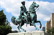
Equestrian statue of George Washington
on
Washington Circle
The
Equestrian statue of George Washington
on
Washington Circle
 In 1877, the
moons of Mars
were discovered at the
Old Naval Observatory
on Potomac Hill.
In 1877, the
moons of Mars
were discovered at the
Old Naval Observatory
on Potomac Hill.
The Foggy Bottom area was the site of one of the earliest European settlements in what is now
Washington, D.C.
, when
German
settler Jacob Funk (or Funck) subdivided 130 acres (0.53 km
2
) near the meeting place of the
Potomac River
and
Rock Creek
in 1763. The settlement officially was named
Hamburgh
, but colloquially was called
Funkstown
. In 1765, German settlers established the town of Hamburg on what would become the area between 24th and 18th NW Street.
[2]
There are reportedly two more founders: Robert Peter and James Linigan.
[2]
The three had control of the land until 1791 when the territories were given to the city of Washington and the United States government. In the town of Hamburg, a German community was founded by many German immigrants.
In 1768, Funk sold two lots of territory to both the German
Lutheran
and the German
Presbyterian
communities. The lot that was sold to the German Lutherans was located on the corner of 20th and G Street. The lot sold to the German Presbyterians was located on the southeast corner of 22nd and G Street. The Lutheran lot would not be in use until 1833 and the Presbyterian until the 1880s.
[2]
The lot that was sold to the German Lutheran community was turned into the
Concordia German Church
.
By the 19th century, Foggy Bottom became a community of laborers employed at the nearby
breweries
, glass plants, and city gas works. These industrial facilities are also cited as a possible reason for the neighborhood's name, the "fog" being the smoke given off by the industries. Foggy Bottom attracted few settlers until the 1850s, when more industrial enterprises came into the area.
[3]
Funk also set aside land in Hamburgh for a German-speaking congregation in 1768. Concordia German Evangelical Church, located at 1920 G Street NW was finally founded in 1833. Today the congregation is the United Church, and is the oldest religious community remaining in Foggy Bottom.
[4]
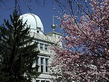
In 1877 the
moons of Mars
(Phobos and Deimos) were discovered from the old
Naval Observatory
in Foggy Bottom, which was located here until 1893.
Foggy Bottom became the site of the
George Washington University
's 42-acre (17 ha) main campus in 1912.
 George Washington University
Foggy Bottom
was also the name of a line of beer by the
Olde Heurich Brewing Company
, which was founded by German immigrant
Christian Heurich
's grandson, Gary Heurich. He tried to revive the tradition of his family's Christian Heurich Brewing Company, which had ceased production in Foggy Bottom. Christian Heurich Brewing Company's most successful products bore such local names as Senate and Old Georgetown. During the 1950s, Heurich Brewing also sponsored the city's professional baseball team, the
Washington Senators
. Industry consolidation led the brewery to cease operations in 1956. In 1961?1962, the brewery buildings were razed to make way for the
John F. Kennedy Center for the Performing Arts
. Heurich Jr., and his two sisters donated a portion of the brewery land to the Kennedy Center in memory of their parents, and established the Christian Heurich Family as one of the Founders of the national cultural center. Although the firm was founded in the Foggy Bottom neighborhood, the modern beer was brewed in
Utica
,
New York
.
Points of interest
[
edit
]
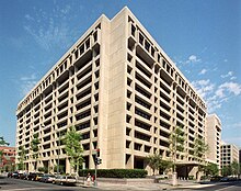
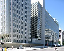 The headquarters of the
World Bank
The headquarters of the
World Bank
United States historic place
|
Foggy Bottom Historic District
|
|
|
|
|
 |
| Location
| Bounded by 17th St., Rock Creek Parkway, Constitution Ave., Pennsylvania Ave., NW,
Washington, D.C.
|
|---|
| NRHP reference
No.
| 87001269
|
|---|
| Added to NRHP
| October 14, 1987
|
|---|
Points of interest in Foggy Bottom include the
Kennedy Center for the Performing Arts
; Friendship Lodge
Odd Fellows
Hall; and the infamous
Watergate complex
, site of the burglaries which led to President
Richard Nixon
's resignation over the
Watergate scandal
. George Washington University has grown significantly over the past decades and now covers much of the neighborhood, which has many historic old homes and numerous mid-rise apartment buildings. The historic portion of the Foggy Bottom neighborhood is preserved and listed on the
National Register of Historic Places
. Just south of the Watergate complex, on the
Potomac River
, lies the
John F. Kennedy Center for the Performing Arts
, home of the
National Symphony Orchestra
and numerous other theatrical and musical exhibitions. On
Virginia Avenue
is the
Simon Bolivar
Memorial. George Washington University's
Lisner Auditorium
and
Smith Center
are frequently home to major concerts, as is
DAR Constitution Hall
. Foggy Bottom is also home to the
original location
of the
United States Naval Observatory
.
The southern edge of Foggy Bottom is home to many federal government offices, including the State Department.
[5]
[6]
The
Main Interior Building
(headquarters of the
Department of the Interior
), the
Bureau of Indian Affairs
headquarters, and the
Federal Reserve Board
buildings all lie on or around
Virginia Avenue
. To the east lies the
Eisenhower Executive Office Building
, home to the
Executive Office of the President of the United States
and the
Office of the Vice President of the United States
. On the other side of the office is the
White House
, outside of the neighborhood.
Foggy Bottom is also home to numerous international and American organizations. The
World Bank
buildings, the
International Finance Corporation
, the
International Monetary Fund
, the
Office of Personnel Management
,
DAR Constitution Hall
of the
Daughters of the American Revolution
, the
American Pharmacists Association
, the
American Red Cross National Headquarters
, the
Pan American Health Organization
, and the
Organization of American States
are all located in the neighborhood. In addition,
the Mexican
and
Spanish embassies
are located in Foggy Bottom, both on
Pennsylvania Avenue
.
Alleys
[
edit
]
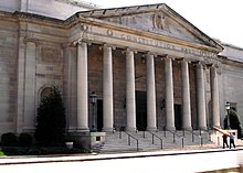 DAR Constitution Hall
 Snows Court
, a historic Foggy Bottom
alley
Snows Court
, a historic Foggy Bottom
alley
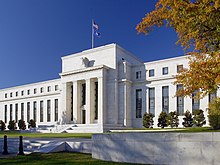 The
Eccles Building
, the headquarters of the
Federal Reserve
The
Eccles Building
, the headquarters of the
Federal Reserve
 The headquarters of the
International Monetary Fund
The headquarters of the
International Monetary Fund
Foggy Bottom, along with the rest of Washington D.C, was designed using the
L'Enfant Plan
, which created squares of housing with open space left in the middle. Foggy Bottom's alley life issue emerged during the 1860s when an influx of
Irish
and
German
immigrants attempted to move into Foggy Bottom.
[7]
This influx was a result of the large number of industrial buildings that were located in Foggy Bottom.
[7]
There were no immediate houses available for these new immigrants, so they were forced to move into the uninhabited alleys that were located in the middle of the squares. The situation became worse after the Civil War when a wave of newly freed Black Americans moved to Washington and began populating the alleys.
Construction of the alleys continued until 1892 because the government needed to reduce overcrowding in residential areas.
[8]
For the next decade, the government largely left the alleys untouched. However, at the turn of the 20th century, the government began relegating more responsibilities and authority to the Health Department, which began demolishing the alleys because of the copious amounts of crime and disease. The living conditions of the inhabitants were quite abysmal, with half of the population sharing or having no toilet facilities
[9]
Furthermore, crime was a major problem; a section of Foggy Bottom was nicknamed "Round Tops" because of a well-known gang that was active in the area.
The following decades showed an improvement in the overall living conditions in the alleys of Foggy Bottom. The Health Department's effort to reduce crime and overcrowding largely succeeded until the 1920s, when prohibition began being enforced. Because breweries were a major source of income for the inhabitants of Foggy Bottom, prohibition created a new wave of lower-class workers who flocked to the alleys to set up bootleg liquor stores.
[9]
During this time, the German and the Irish immigrants that had been prevalent since the 1860s began to move out.
[9]
In 1934, after conditions in the alley had deteriorated, the government created the
Alley Dwelling Authority
, a new government entity that specifically dealt with improving Washington D.C.’s alleys. The ADA was authorized to demolish or redevelop any alley if it was deemed to be worth saving or not. The addition of the ADA and the arrival of the Department of State began to improve the living conditions in the alleys over time.
[9]
The ADA was given the task of evaluating homes and streets to see if they met proper living conditions. Specific documentation would state the reasons why the area needed to be renovated. This documentation would then be sent from the authority to legislation for approval. Individual legislators included, but not exclusively,
Eleanor Roosevelt
. Common reasons given for why an area was in need of renovation were: too many people in one home; too many African Americans in and around the area; or that the exterior paint had faded. After the ADA gained approval from legislation, it would then give the occupants of the houses anywhere from two to four months to vacate the building. By July 1, 1944, all of the houses in Foggy Bottom had been evacuated and plans were set forward for renovation. This act sought to produce larger living spaces for individuals with better conditions so that the owners could charge more for rent. Higher rent prices were acceptable at the time because of a boom in hiring. Rents usually ranged anywhere from seventeen to thirty-seven dollars a month. These prices fluctuated often because of the available jobs and the condition of the houses. Older houses were typically cheaper than new homes, only some of which came with running water, gas heaters or cooling systems. Statistics suggest that, on average, the greater wealth arose from the majority of white residents, but also that black wealth was steadily increasing due to new job patterns.
[10]
West Station Works
[
edit
]
 The
Harry S. Truman Building
, the headquarters of the
U.S. Department of State
The
Harry S. Truman Building
, the headquarters of the
U.S. Department of State
In 1856, construction began on the West Station Works, a plant owned and operated by the Washington Gas Light corporation, at the intersections of 26th and G St. NW.
[11]
The construction began the development of the area now occupied by the
Watergate complex
and throughout broader Foggy Bottom. The location was chosen for its proximity to the
Potomac River
, which made it convenient to unload barges of
coal
for the plant.
[12]
[13]
The daily operation of the West Station Works attracted laborers to the area, most of them unskilled.
By 1860, the unskilled population in Foggy Bottom was at 42%, compared to 9% in 1850.
[14]
The influx of people spurred development in the area, and 40 years after the works were completed, the area fit the description of a proper city. In 1948, the area of land occupied by the West Station Works was purchased by the Watergate Project.
[15]
The plant was demolished, and the
Watergate complex
was constructed on the same plot of land. Today, there is no physical remnant of the plant. It is a historical location today.
Geography
[
edit
]
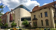 The Textile Museum
at
George Washington University
The Textile Museum
at
George Washington University
It is bounded roughly by 17th Street NW to the east, the
Potomac River
and
Rock Creek Parkway
to the west,
Constitution Avenue
and the
National Mall
to the south, and
Pennsylvania Avenue
NW to the north.
Foggy Bottom is thought to have received its name due to an atmospheric quirk of its low lying, marshy riverside location, which made it susceptible to concentrations of
fog
, and later, industrial smoke. The
United States Department of State
gained the
metonym
"Foggy Bottom"
[16]
when it moved its headquarters to the
Harry S Truman Building
in 1947.
[5]
[6]
Demographics
[
edit
]
 The headquarters of the
Pan American Health Organization
The headquarters of the
Pan American Health Organization
Late into the 20th century, Foggy Bottom witnessed a drastic change in demographics. There was a racial transformation within the area, as a white revival emerged. Many different factors forced out the black population, including the Foggy Bottom Taxpayers Protective Association opposing federal intervention. The renovations enacted by the Alley Dwelling Authority rendered the former inhabitants displaced. Similarly, the West End witnessed the same changes.
[17]
Another factor of the change in demographics was orchestrated by Democratic Senator
Theodore G. Bilbo
, who called for an "Alley Moving Day" forcing the black population out of the alleys.
The neighborhood is predominately white and has a large number of off-campus university student residents that affect demographics on income, age and race. As of the
2010 United States Census
, there are 14,642 residents, of whom 78.3% are white.
[18]
Transportation
[
edit
]
The Foggy Bottom neighborhood is served by:
- Foggy Bottom ? GWU
Washington Metro
station, on the
Blue
,
Orange
, and
Silver Lines
.
- Metrobus
routes 31,
32, 36
, 37, 38B, 39, 80, H1, L1, N3, S1, and X1
- Rentable
bikes
and
electric scooters
are readily available
Education
[
edit
]
 The President's Office
at
George Washington University
, built 1892
The President's Office
at
George Washington University
, built 1892
George Washington University
(GWU) is located in Foggy Bottom.
Public schools in Foggy Bottom are part of the
District of Columbia Public Schools
(DCPS) system. The neighborhood elementary and middle school located in Foggy Bottom is
School Without Walls at Francis-Stevens
.
[19]
Residents are zoned for
Cardozo Education Campus
for high school. DCPS also operates
School Without Walls
, a magnet high school, on the GWU campus.
[20]
See also
[
edit
]
References
[
edit
]
- ^
https://www.foggybottomassociation.org/post/funkstown-no-4-what-makes-the-foggy-bottom-district-historic
- ^
a
b
c
Sherwood, Suzanne Berry (1978).
Foggy Bottom: A History of land Use in Foggy Bottom, Washington D.C, 1800-1975
. Washington: George Washington University Press. pp. 5?8.
- ^
"FB.1"
(PDF)
. Planning.dc.gov. Archived from
the original
(PDF)
on November 5, 2010
. Retrieved
September 15,
2012
.
- ^
"The United Church + Die Vereinigte Kirche"
. Theuntitedchurch.org
. Retrieved
September 15,
2012
.
- ^
a
b
Alex Carmine. (2009.)
Dan Brown's The Lost Symbol: The Ultimate Unauthorized and Independent Reading Guide
, Punked Books, p. 37.
ISBN
9781908375018
.
- ^
a
b
Joel Mowbray. (2003.)
Dangerous Diplomacy: How the State Department Threatens America's Security
, Regnery Publishing, p. 11.
ISBN
9780895261106
.
- ^
a
b
"Foggy Bottom Historic District"
.
Nps.gov
.
- ^
"Foggy Bottom Historic District"
(PDF)
.
Dc.gov
. Archived from
the original
(PDF)
on November 9, 2013
. Retrieved
May 2,
2013
.
- ^
a
b
c
d
.
"How Foggy Bottom Changed"
.
Dcentric.com
.
- ^
Borchert, James. Alley Life in Washington: Family, Community, Religion, and Folklife in the City, 1850-1970. Urbana: University of Illinois, 1980.
ISBN
9780252006890
.
- ^
Robert R. Hershman and Edward T. Stafford, Growing With Washington: The Story of Our First Hundred Years (Washington, D.C. Judd & Detweiler 1948), p.20, read from original at MLK Washingtoniana Collection
- ^
W. Noland, Documents relating to the bill (S. 329) "to provide for lighting the Capitol and President's Squares, and the Pennsylvania Avenue, with carbureted hydrogen gas, April 13, 1840, Congressional Proquest, document number: S.doc.434
- ^
Hershman and Stafford p.22
- ^
Suzanne Berry Sherwood, Foggy Bottom 1800-1975: a study in the uses of an urban neighborhood (GW 1978), p.5. found in GLSC
- ^
The Washington Post, Watergate, Gas Co. Sign Unusual Pact, September 9, 1964, ProQuest Historical Newspapers, Document ID: 142181248
- ^
"Definition of Foggy Bottom"
.
The American Heritage Dictionary of the English Language
. Retrieved
April 10,
2017
.
- ^
Asch, Chris Myers, and George Derek Musgrove. "Not Gone, Not Forgotten: Struggling over History in a Gentrifying D.C."
The Washington Post
, 19 Oct. 2012. Web. 21 May 2013.
- ^
"2010 Census"
.
Zip-codes.com
. 2010.
- ^
"School Without Walls @ Francis-Stevens"
.
dcps.dc.gov
. Retrieved
February 8,
2019
.
- ^
"Stepping foot (sic) inside a different classroom on campus"
.
The GW Hatchet
. February 13, 2014
. Retrieved
February 8,
2019
.
Further reading
[
edit
]
External links
[
edit
]
Places adjacent to Foggy Bottom
|
|---|
|
|
|---|
| Ward 1
| |
|---|
| Ward 2
| |
|---|
| Ward 3
| |
|---|
| Ward 4
| |
|---|
| Ward 5
| |
|---|
| Ward 6
| |
|---|
| Ward 7
| |
|---|
| Ward 8
| |
|---|
38°53′54″N
77°02′56″W
/
38.89833°N 77.04889°W
/
38.89833; -77.04889