From Wikipedia, the free encyclopedia
Original file
(SVG file, nominally 1,713 × 1,435 pixels, file size: 79 KB)
Summary
- You are free:
- to share
? to copy, distribute and transmit the work
- to remix
? to adapt the work
- Under the following conditions:
- attribution
? You must give appropriate credit, provide a link to the license, and indicate if changes were made. You may do so in any reasonable manner, but not in any way that suggests the licensor endorses you or your use.
- share alike
? If you remix, transform, or build upon the material, you must distribute your contributions under the
same or compatible license
as the original.
https://creativecommons.org/licenses/by-sa/3.0
CC BY-SA 3.0
Creative Commons Attribution-Share Alike 3.0
true
true
Original upload log
This image is a derivative work of the following images:
- File:SouthAfrica1885.jpg
licensed with Cc-pd-mark-footer, PD-old
- 2006-03-26T19:54:51Z
Julo
1906x1648 (782758 Bytes)
corrected purple for Portugese posessions
Uploaded with
derivativeFX
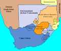
Map of South Africa in July 1885, showing British possessions and protectorates, the two Boer Republics, besides German South West Africa and Portuguese Mozambique, bordered by the Atlantic and Indian Oceans
Kaart van Zuid-Afrika in juli 1885 met de Britse bezittingen en protectoraten, de twee Boerenrepublieken (Transvaal of ZAR, en Oranje-Vrijstaat), en tevens Duits-Zuidwest-Afrika en Portugees Mozambique grenzend aan de Atlantische en Indische Oceaan.
File history
Click on a date/time to view the file as it appeared at that time.
| Date/Time
| Thumbnail
| Dimensions
| User
| Comment
|
|---|
| current
| 14:27, 29 December 2022
|  | 1,713 × 1,435
(79 KB)
| Lks.poch
| File uploaded using svgtranslate tool (https://svgtranslate.toolforge.org/). Added translation for ca.
|
| 20:28, 19 August 2022
|  | 1,713 × 1,435
(71 KB)
| Dymitr
| File uploaded using svgtranslate tool (https://svgtranslate.toolforge.org/). Added translation for be-tarask.
|
| 20:28, 19 August 2022
|  | 1,713 × 1,435
(71 KB)
| Dymitr
| File uploaded using svgtranslate tool (https://svgtranslate.toolforge.org/). Added translation for be-tarask.
|
| 20:22, 19 August 2022
|  | 1,713 × 1,435
(71 KB)
| Dymitr
| File uploaded using svgtranslate tool (https://svgtranslate.toolforge.org/). Added translation for be-tarask.
|
| 19:41, 10 February 2022
|  | 1,713 × 1,435
(61 KB)
| TheNickFer
| File uploaded using svgtranslate tool (https://svgtranslate.toolforge.org/). Added translation for it.
|
| 05:59, 2 January 2022
|  | 1,713 × 1,435
(53 KB)
| Qutlook
| File uploaded using svgtranslate tool (https://svgtranslate.toolforge.org/). Added translation for bg.
|
| 13:18, 21 September 2011
|  | 1,713 × 1,435
(47 KB)
| Themightyquill
| {{Information |Description=Map of
South Africa
showing British Possessions July 1885 |Source=*
File:SouthAfrica1885.jpg
|Date=2011-09-21 13:17 (UTC) |Author=*
File:SouthAfrica1885.jpg
: John George Bartholomew *derivative work: ~~~ |Permissio
|
File usage
The following pages on the English Wikipedia use this file (pages on other projects are not listed):
Global file usage
The following other wikis use this file:
- Usage on af.wikipedia.org
- Usage on ar.wikipedia.org
- Usage on azb.wikipedia.org
- Usage on be-tarask.wikipedia.org
- Usage on bg.wikipedia.org
- Usage on de.wikipedia.org
- Usage on el.wikipedia.org
- Usage on es.wikipedia.org
- Usage on ga.wikipedia.org
- Usage on it.wikipedia.org
- Usage on ja.wikipedia.org
- Usage on lv.wikipedia.org
- Usage on nl.wikipedia.org
- Usage on ru.wikipedia.org
- Usage on simple.wikipedia.org
- Usage on sl.wikipedia.org
- Usage on zh.wikipedia.org
This file contains additional information, probably added from the digital camera or scanner used to create or digitize it.
If the file has been modified from its original state, some details may not fully reflect the modified file.
