From Wikipedia, the free encyclopedia

No higher resolution available.
Summary
Licensing
I, the copyright holder of this work, hereby publish it under the following license:
- You are free:
- to share
? to copy, distribute and transmit the work
- to remix
? to adapt the work
- Under the following conditions:
- attribution
? You must give appropriate credit, provide a link to the license, and indicate if changes were made. You may do so in any reasonable manner, but not in any way that suggests the licensor endorses you or your use.
- share alike
? If you remix, transform, or build upon the material, you must distribute your contributions under the
same or compatible license
as the original.
https://creativecommons.org/licenses/by-sa/2.5
CC BY-SA 2.5
Creative Commons Attribution-Share Alike 2.5
true
true
Add a one-line explanation of what this file represents
File history
Click on a date/time to view the file as it appeared at that time.
| Date/Time
| Thumbnail
| Dimensions
| User
| Comment
|
|---|
| current
| 20:26, 27 March 2007
|  | 500 × 500
(121 KB)
| Kmusser
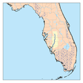
| This is a map of the
Peace River
watershed. I,
Karl Musser
, created it based on
USGS
data. {{self|cc-by-sa-2.5}}
Category:Maps of rivers of the United States
|
File usage
The following pages on the English Wikipedia use this file (pages on other projects are not listed):
Global file usage
The following other wikis use this file:
- Usage on ar.wikipedia.org
- Usage on bg.wikipedia.org
- Usage on fr.wikipedia.org
- Usage on ru.wikipedia.org
