From Wikipedia, the free encyclopedia
Original file
(SVG file, nominally 1,260 × 1,835 pixels, file size: 943 KB)
Add a one-line explanation of what this file represents
File history
Click on a date/time to view the file as it appeared at that time.
| Date/Time
| Thumbnail
| Dimensions
| User
| Comment
|
|---|
| current
| 19:22, 13 September 2019
|  | 1,260 × 1,835
(943 KB)
| Hogweard
| Colours
|
| 23:31, 12 January 2015
|  | 1,250 × 1,835
(933 KB)
| Visitor from Wikishire
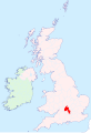
| {{Information |Description=Oxfordshire location map |Source=
British Isles in counties.svg
|Date=2014-01-11 |Author=
User:Visitor from Wikishire
|Permission={{PD-self}} |other_versions= }} [[Category:Maps of hi...
|
File usage
The following pages on the English Wikipedia use this file (pages on other projects are not listed):
Global file usage
The following other wikis use this file:
- Usage on ku.wikipedia.org
- Usage on nl.wikipedia.org
This file contains additional information, probably added from the digital camera or scanner used to create or digitize it.
If the file has been modified from its original state, some details may not fully reflect the modified file.
