From Wikipedia, the free encyclopedia
Original file
(SVG file, nominally 555 × 792 pixels, file size: 1.69 MB)
Summary
Add a one-line explanation of what this file represents
File history
Click on a date/time to view the file as it appeared at that time.
| Date/Time
| Thumbnail
| Dimensions
| User
| Comment
|
|---|
| current
| 12:34, 15 October 2020
|  | 555 × 792
(1.69 MB)
| Hogweard
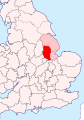
| {{Information |description=Location of Kesteven in Lincolnshire, on a section of Great Britain |date=2020-10-15 |source=*{{f|Lincolnshire - British Isles.svg}} *{{Wikishire data}} |author={{u|Hogweard}} |permission={{PD-self}} |other versions= }}
Category:Maps of historic counties of the United Kingdom
Category:SVG locator maps of counties of the United Kingdom
Category:Maps of Lincolnshire
|
File usage
The following pages on the English Wikipedia use this file (pages on other projects are not listed):
Global file usage
The following other wikis use this file:
- Usage on sv.wikipedia.org
- Usage on tr.wikipedia.org
This file contains additional information, probably added from the digital camera or scanner used to create or digitize it.
If the file has been modified from its original state, some details may not fully reflect the modified file.
