From Wikipedia, the free encyclopedia
Original file
(SVG file, nominally 1,108 × 1,345 pixels, file size: 307 KB)
Summary
Licensing
Attribution:
Dr Greg
- You are free:
- to share
? to copy, distribute and transmit the work
- to remix
? to adapt the work
- Under the following conditions:
- attribution
? You must give appropriate credit, provide a link to the license, and indicate if changes were made. You may do so in any reasonable manner, but not in any way that suggests the licensor endorses you or your use.
- share alike
? If you remix, transform, or build upon the material, you must distribute your contributions under the
same or compatible license
as the original.
https://creativecommons.org/licenses/by-sa/3.0
CC BY-SA 3.0
Creative Commons Attribution-Share Alike 3.0
true
true
Original upload log
This image is a derivative work of the following images:
- File:England_Admin_Counties_1890-1965.png
licensed with Cc-by-sa-3.0, GFDL
- 2010-08-31T19:50:31Z
XrysD
2625x3256 (1137803 Bytes)
Fixed typos (West/East transposed for Sussex and Suffolk).
- 2010-07-25T10:14:22Z
XrysD
2625x3256 (1137810 Bytes)
{{Information |Description={{en|1=Map of the administrative counties of England from 1890 to 1965}} |Source={{own}} |Author=[[User:XrysD|XrysD]] |Date=2010-07-25 |Permission= |other_versions= }}
- File:English_ceremonial_counties_2010.svg
licensed with Cc-by-sa-3.0, GFDL
- 2010-11-23T16:39:55Z
Nilfanion
1108x1345 (308868 Bytes)
thicker lines
- 2010-11-23T16:20:19Z
Nilfanion
1108x1345 (301520 Bytes)
tweaks
- 2010-10-26T20:34:20Z
Nilfanion
817x990 (1391832 Bytes)
{{Information |Description=Map showing the [[w:ceremonial counties of England]] including the City of London, in 2010. Equirectangular map projection on WGS 84 datum, with N/S stretched 170% Geographic limits: *West: 6.75W
Uploaded with
derivativeFX
Add a one-line explanation of what this file represents
File history
Click on a date/time to view the file as it appeared at that time.
| Date/Time
| Thumbnail
| Dimensions
| User
| Comment
|
|---|
| current
| 23:14, 20 March 2012
|  | 1,108 × 1,345
(307 KB)
| Dr Greg
| correction to status of Ireland in 1889
|
| 21:05, 19 March 2012
|  | 1,108 × 1,345
(310 KB)
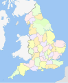
| Dr Greg
| == {{int:filedesc}} == {{Information |Description={{en|1=Map of the geographical counties of England from 1889 to 1965, excluding the City of London. Also shows the ridings of Yorkshire. Equirectangular map projection on WGS 84 datum, with N/S stret...
|
File usage
The following pages on the English Wikipedia use this file (pages on other projects are not listed):
Global file usage
The following other wikis use this file:
- Usage on ar.wikipedia.org
- Usage on ja.wikipedia.org
