From Wikipedia, the free encyclopedia
Original file
(6,300 × 4,201 pixels, file size: 8.75 MB, MIME type:
image/png
)
Add a one-line explanation of what this file represents
File history
Click on a date/time to view the file as it appeared at that time.
| Date/Time
| Thumbnail
| Dimensions
| User
| Comment
|
|---|
| current
| 18:13, 14 March 2023
|  | 6,300 × 4,201
(8.75 MB)
| Hlj
| improved graphics
|
| 17:51, 30 December 2012
|  | 2,500 × 1,822
(1.4 MB)
| Hlj
| Corrected spelling error, made minor graphic improvements
|
| 22:15, 3 June 2011
|  | 2,500 × 1,822
(1.36 MB)
| Hlj
| Improved the accuracy of the terrain and some landmarks. Same license.
|
| 19:32, 27 March 2011
|  | 2,500 × 1,822
(1.32 MB)
| Hlj
| Update to graphical style of rivers and roads. Same license.
|
| 21:59, 27 January 2011
|  | 2,500 × 1,822
(1.02 MB)
| Hlj
| Minor updates to feature labeling and unit positions and actions. {{cc-by-3.0|Map by Hal Jespersen, www.posix.com/CW}}
|
| 00:13, 28 November 2010
|  | 2,500 × 1,822
(1.01 MB)
| Hlj
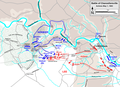
| {{Information |Description={{en|1=Map of a portion (May 1) of the battle of Chancellorsville of the
American Civil War
. this map partially replaces the map entitled Chancellorsville May1 2.png. Drawn in Adobe Illustrator CS5 by Hal Jespersen. Graphic
|
File usage
The following pages on the English Wikipedia use this file (pages on other projects are not listed):
Global file usage
The following other wikis use this file:
- Usage on bg.wikipedia.org
- Usage on es.wikipedia.org
- Usage on fr.wikipedia.org
- Usage on hu.wikipedia.org
- Usage on ms.wikipedia.org
- Usage on pt.wikipedia.org
- Usage on ro.wikipedia.org
- Usage on ru.wikipedia.org
This file contains additional information, probably added from the digital camera or scanner used to create or digitize it.
If the file has been modified from its original state, some details may not fully reflect the modified file.
