From Wikipedia, the free encyclopedia
Original file
(1,144 × 837 pixels, file size: 205 KB, MIME type:
image/jpeg
)
Summary
Licensing
I, the copyright holder of this work, hereby publish it under the following license:
- You are free:
- to share
? to copy, distribute and transmit the work
- to remix
? to adapt the work
- Under the following conditions:
- attribution
? You must give appropriate credit, provide a link to the license, and indicate if changes were made. You may do so in any reasonable manner, but not in any way that suggests the licensor endorses you or your use.
https://creativecommons.org/licenses/by/3.0
CC BY 3.0
Creative Commons Attribution 3.0
true
true
Add a one-line explanation of what this file represents
File history
Click on a date/time to view the file as it appeared at that time.
| Date/Time
| Thumbnail
| Dimensions
| User
| Comment
|
|---|
| current
| 19:02, 19 January 2010
|  | 1,144 × 837
(205 KB)
| BrineStans
| fixing contrast to unflatten
|
| 17:36, 25 August 2008
|  | 1,171 × 869
(178 KB)
| BrineStans
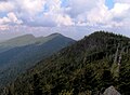
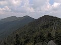
| {{Information |Description={{en|1=The crest of the north-central Black Mountains in Yancey County, North Carolina, in the southeastern United States. From left to right: Cattail Peak, Balsam Cone, and Big Tom. Part of Potato Hill can be seen just over t
|
File usage
The following pages on the English Wikipedia use this file (pages on other projects are not listed):
This file contains additional information, probably added from the digital camera or scanner used to create or digitize it.
If the file has been modified from its original state, some details may not fully reflect the modified file.
