Tallest mountain in Vietnam
Fansipan
(
Vietnamese
:
Phan Xi P?ng
,
listen
ⓘ
) is a mountain in
Vietnam
. Its height was 3,143 metres (10,312 ft) in 1909, and it presently stands at 3,147.3 metres (10,326 ft).
[1]
It is the highest mountain on the
Indochinese peninsula
(comprising Vietnam,
Laos
, and
Cambodia
), hence its nickname, "the Roof of Indochina". It is located in the
Lao Cai province
of the Northwest region of Vietnam,
nine kilometres (
5
+
1
⁄
2
miles) southwest of
Sa Pa
, in the Hoang Lien Son mountain range. Administratively, it is shared between
Tam đ??ng District, Lai Chau
and
Sa Pa
town.
Etymology
[
edit
]
The origin of the name
Phan Xi P?ng
is unclear. The most commonly accepted theory is that it evolved from
H?a Xi Pan
("the tottering giant rock")?the name that the locals called the mountain, based on its shape. Another theory suggests that the name came from the
Hmong people
, as it means "azalea mountain" in
their language
, due to the prevalence of
azaleas
and other species of the
Rhododendron
genus on the mountain.
[3]
It has also been suggested that the name could have derived from
Phan V?n S?n
, a geography official in the
Nguy?n dynasty
who helped the French map the area and define the border with China in 1905. Due to the inaccurate local pronunciation, the name generally evolved into
Phan Xi P?ng
.
[3]
Geography
[
edit
]
Fansipan is the tallest mountain in the Hoang Lien Son range, situated on the border of
Lao Cai
and
Lai Chau provinces
, with its peak located on the Lao Cai side. The mountain is part of
Hoang Lien National Park
. It has a
topographic prominence
of 1,613 metres (5,292 ft), ranking sixth in Vietnam.
[2]
Geology
[
edit
]
Fansipan was formed around 250?260 million years ago, between the
Permian
period in the
Paleozoic
era and the
Triassic
period in the
Mesozoic
.
[4]
The
Himalayan orogeny
since Late Mesozoic has further uplifted Fansipan and the Hoang Lien Son range and created the
Red River Fault
to the east.
[5]
Summit mark
[
edit
]
The initial metal pyramid was made and installed on the mountain's peak by Soviet engineers from
Hoa Binh province
, in 1985. The amateur mountaineering expedition was the first since the end of the
colonial period
and was officially timed to the 40th anniversary of
Victory Day
of the Soviet Union over Nazi Germany.
Climbing
[
edit
]
Hiking
[
edit
]
Fansipan can be climbed in a steep and fairly strenuous hike. Previously, it took about 5?6 days from
Sa Pa
to reach the peak and return. Now, the total time is usually only about three days, even two, or for experts and strong, healthy people, it can be done in one day.
[
clarification needed
]
[
citation needed
]
Tour companies in the area will arrange hikes to the summit that take one to three days. Most recommend taking the two- or three-day options, and few guides will take tourists on a round trip in a single day.
[6]
A very small village is located at around 1,500 m (4,920 ft), where accommodation and food is offered. Further up, at 2,800 m (9,190 ft), is an overnight camp. Most booked trips include the use of these facilities in their price, should they be required.
[
citation needed
]
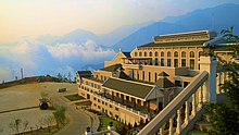
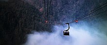
Cable car
[
edit
]
 Cable car station going to Fansipan
 Fansipan peak uplink
A cable car to the peak of Fansipan was inaugurated on 2 February 2016.
[7]
The
gondola lift
departs from a terminal in
Muong Hoa valley
, near Sa Pa, and takes twenty minutes to reach the summit. The service holds two
Guinness World Records
for the longest nonstop, three-rope cable car in the world, spanning
6.3 km (
3
+
15
⁄
16
mi), and the greatest elevation difference by a nonstop, three-roped cable car for the 1,410 m (4,626 ft) difference in elevation between the termini.
[8]
Currently, there are also climbing trains that help climbers get past the walking stairs.
[9]
See also
[
edit
]
References
[
edit
]