District in Kerala, India
Ernakulam district
|
|---|
|
|
|
 |
 Ernakulam District
|
| Coordinates:
10°00′N
76°20′E
/
10.00°N 76.33°E
/
10.00; 76.33
|
| Country
|  India
India
|
|---|
| State
| Kerala
|
|---|
| Named for
| Rishinagakulam
[
citation needed
]
|
|---|
| Headquarters
| Kakkanad
, Kochi
|
|---|
|
| ? Collector
| N.S.K. Umesh , IAS
|
|---|
| ? Commissioner & IG (Kochi)
| C. Nagaraju, IPS
|
|---|
| ? S.P (Ernakulam Rural)
| K.Karthik, IPS
|
|---|
| ? DFO
| A. Renjan, IFS
|
|---|
|
| ? Total
| 2,924 km
2
(1,129 sq mi)
|
|---|
| ? Rank
| 6th
|
|---|
|
| ? Total
| 3,427,659
[1]
|
|---|
| ? Density
| 1,119/km
2
(2,900/sq mi)
|
|---|
|
| ? Official
| Malayalam
|
|---|
| Time zone
| UTC+5:30
(
IST
)
|
|---|
| ISO 3166 code
| IN-KL-KO
, IN-KL
|
|---|
| Vehicle registration
| |
|---|
| HDI
(2005)
|  0.801
[3] 0.801
[3]
very high
|
|---|
| Website
| ernakulam
.nic
.in
|
|---|
 Inchathotty Bridge near
Kothamangalam
Inchathotty Bridge near
Kothamangalam
Ernakulam
(
IPA:
[er???ːgu??m]
ⓘ
;
ISO
:
E?a??ku?a?
) is one of the
14 districts
in the
Indian state
of
Kerala
, and takes its name from the
eponymous city division
in
Kochi
. It is situated in the central part of the state, spans an area of about 2,924 square kilometres (1,129 sq mi), and is home to over 9% of Kerala's population. Its headquarters are located at
Kakkanad
. The district includes Kochi, also known as the commercial capital of Kerala, which is famous for its ancient
churches
,
Hindu temples
,
synagogues
and
mosques
.
The district includes the largest metropolitan region of the state:
Greater Cochin
. Ernakulam district yields the highest revenue and the largest number of industries in the state.
[4]
Ernakulam is the third most populous district in Kerala, after
Malappuram
and
Thiruvananthapuram
(out of
14 districts
).
[5]
The district also hosts the highest number of international and domestic tourists in Kerala state.
The most commonly spoken language in Ernakulam is
Malayalam
. English is widely used, mostly in business circles. Ernakulam became India's first district to have 100 percent banking or full "meaningful financial inclusion" in 2012.
[6]
[7]
Ernakulam has a high
Human Development Index
of 0.801 (UNHDP report 2005), which is one of the highest in India.
[8]
Etymology
[
edit
]
![[icon]](//upload.wikimedia.org/wikipedia/commons/thumb/1/1c/Wiki_letter_w_cropped.svg/20px-Wiki_letter_w_cropped.svg.png) | This section is empty.
You can help by
adding to it
.
(
August 2023
)
|
History
[
edit
]
 Rama Varma XV at the
Delhi Durbar of 1903
.
Rama Varma XV at the
Delhi Durbar of 1903
.
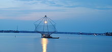 Chinese fishing nets
,
Fort Kochi
Chinese fishing nets
,
Fort Kochi
Ernakulam has played a part in the political history of
south India
since ancient times. The
Jews
,
Syrians
,
Arabs
, Chinese, Dutch, British, and
Portuguese
seafarers followed the sea route to the
Kingdom of Cochin
and left their impressions on the town. The port at
Kozhikode
held superior economic and political position in medieval Kerala coast, while
Kannur
,
Kollam
, and
Kochi
, were commercially important secondary ports, where the traders from various parts of the world would gather.
[9]
In 1664, the municipality of
Fort Kochi
was established by
Dutch Malabar
, making it the first municipality in
Indian subcontinent
, which got dissolved when the Dutch authority got weaker in 18th century.
[10]
In 1896, the Maharaja of Cochin initiated local administration by forming a town council in Ernakulam. Initially, The district's headquarters were located in the portion of the city known as
Ernakulam
, which gave the district its name; the headquarters was relocated afterwards to
Kakkanad
.
In the year 1998,
Kuttampuzha
village was added to the district from
Idukki district
following which the district got a political boundary with neighbouring state of
Tamil Nadu
. There is no interstate road that connects the district with the neighbouring state through this border.
Geography
[
edit
]
The Ernakulam district covers an area of 3,068 km
2
(1,185 sq mi) on the Western Coastal Plains of India. It is surrounded by the
Thrissur District
to the north, the
Idukki District
to the east,
Alappuzha
and
Kottayam
districts to the south and the
Laccadive Sea
to the west. The
Anamalais
occupy a large part of the district, consisting of the forest areas around
Pooyamkutty
and the
Idamalayar Dam
. The range also extends into Thrissur, Palakkad, and Idukki districts, as well as Coimbatore and Tiruppur districts of Tamil Nadu. The district is divided geographically into highland, midland, and coastal area. The altitude of the highlands is about 300 m (980 ft). The
Periyar River
, Kerala's longest, flows through all the
taluks
except
Muvattupuzha
. The
Muvattupuzha River
and a branch of the
Chalakkudy River
also flow through the district. The average yearly rainfall in the district is 3,432 mm (135.1 in). The district has a moderate climate and mostly falls within the
Malabar Coast moist forests
ecoregion, while the highlands are part of the
South Western Ghats moist deciduous forests
ecoregion. The
Anamudi
is the tallest peak in South India, on the border of Ernakulam and Idukki districts. Some parts of the Idamalayar Reserve Forest and Mankulam Forest Division have
Sholas
but these parts are inaccessible by road. The Idamalayar Reserve Forest, and
Edamalakkudy
. Many types of sand, soil, and rocks are abundant here. Cochin International Airport is located in the northern part of the district at
Nedumbassery
, Kochi.
The district houses two Urban Agglomerations,
Kochi
and
Kothamangalam
. Kochi is the largest city in the state, and 17th most populous in the country according to the
Ministry of Housing and Urban Affairs
rankings based on the 2011 Census, with an area of over 843km2 and 2.12 million population.
Topography
[
edit
]
The district is divided into three parts: lowland, midland, and the highland that consist of seaboard, plains, and hills and forests respectively. 20 percent of the total area are lowlands. The forests in the eastern part of the district are mostly remote, forming a part of the
Anamalais
. The highest peak is the
Anamudi
. The midland consists mainly of plain land and a group of islands that naturally drain water via backwaters and canals. The hilly or eastern portion is formed by a section of the
Western Ghats
.
Muvattupuzha
and
Kothamangalam
taluks, which were initially parts of the
Kottayam
district and constitute the highlands.
Muvattupuzhayar
and
Periyar
are the main rivers, of which the latter flows through
Muvattupuzha
,
Aluva
,
Kunnathunad
and
Parur
taluks. During the rainy season these rivers are full and heavy floods affect the low-lying areas on the banks, but in the summer season, they generally go dry and narrow. The Periyar is stretched over a length of 229 km (142 mi).
Forest and wildlife
[
edit
]
 The Grey hornbill
The flora of this district is tropical. The heavy rainfall combined with moderate temperatures and fertile soil support abundant vegetation. Many of the common plants are found in the coastal area, which forms the lowland region. The midland region is occupied by coconut palms, paddy, tapioca, pepper, pineapple and pulses. The lower slopes of the highland region have teak and rubber.
Mangalavanam Bird Sanctuary
[
edit
]
 Mangalavanam
Mangalavanam Bird Sanctuary
is located at the centre of
Kochi
. It covers 2.74 ha (6.8 acres),
[11]
supports many species of
mangroves
and is a nesting ground for a variety of
migratory birds
. The Managalavanam is called the "green lung of Kochi",
[12]
considering its role in controlling the city's air pollution.
[13]
Thattekad Bird Sanctuary
[
edit
]
Thattekad Bird Sanctuary
lies on the northern bank of the
Periyar River
and covers about 25 km
2
(10 sq mi). It was founded by ornithologist
Salim Ali
. The sanctuary is 80 km (50 mi) from Kochi. Birds found here include falcons, jungle fowl, water hens, and
hornbills
. The flora of this area consists mainly of plantations of
teak
,
rosewood
, and mahogany. Further on the road,
Pooyamkutty
forest of the
Anamalais
is reached.
Climate
[
edit
]
| Climate data for Kochi
|
| Month
|
Jan
|
Feb
|
Mar
|
Apr
|
May
|
Jun
|
Jul
|
Aug
|
Sep
|
Oct
|
Nov
|
Dec
|
Year
|
| Record high °C (°F)
|
35
(95)
|
37
(99)
|
37
(99)
|
34
(93)
|
35
(95)
|
33
(91)
|
35
(95)
|
35
(95)
|
38
(100)
|
35
(95)
|
34
(93)
|
33
(91)
|
38
(100)
|
| Mean daily maximum °C (°F)
|
30
(86)
|
31
(88)
|
31
(88)
|
31
(88)
|
31
(88)
|
28
(82)
|
28
(82)
|
28
(82)
|
28
(82)
|
29
(84)
|
30
(86)
|
30
(86)
|
30
(86)
|
| Mean daily minimum °C (°F)
|
23
(73)
|
25
(77)
|
26
(79)
|
26
(79)
|
26
(79)
|
25
(77)
|
24
(75)
|
24
(75)
|
25
(77)
|
25
(77)
|
25
(77)
|
23
(73)
|
25
(77)
|
| Record low °C (°F)
|
17
(63)
|
18
(64)
|
20
(68)
|
21
(70)
|
22
(72)
|
21
(70)
|
21
(70)
|
20
(68)
|
22
(72)
|
20
(68)
|
20
(68)
|
19
(66)
|
17
(63)
|
| Average
precipitation
mm (inches)
|
21.9
(0.86)
|
22.9
(0.90)
|
35.3
(1.39)
|
124.0
(4.88)
|
395.7
(15.58)
|
720.7
(28.37)
|
697.2
(27.45)
|
367.8
(14.48)
|
289.4
(11.39)
|
302.3
(11.90)
|
175.1
(6.89)
|
48.3
(1.90)
|
3,228.3
(127.10)
|
| Source 1:
[14]
|
| Source 2:
[15]
|
Economy
[
edit
]
 Kochi Marine Drive Day View
 The beauty in the night,
Marine Drive, Kochi
The beauty in the night,
Marine Drive, Kochi
 Infopark, Kochi
Ernakulam district is the richest district in Kerala and is the biggest commercial centre in the state of
Kerala
. It contributes the most to the state exchequer in terms of GSVA and tax revenues. It has the highest literacy rate as well as the highest per capita income in the state, along with having the greatest number of commercialised banks, startups and large-scale industries & MSMEs in the state.
Its M.G. Road is home to some of
Kerala
's most prestigious enterprises. Kochi is also the headquarters of some large companies like
Lulu Group International
,
Federal Bank
,
Geojit
,
V-Guard
, and
Muthoot
.
The sea along the entire coast of the district and its backwaters are the habitat of various kinds of fish that supply both marine and inland fisheries.
Agriculture
[
edit
]
The eastern part of Ernakulam is primarily agrarian in nature.
Rice
is the principal crop cultivated in the wetlands. The district is the largest producer of
nutmeg
and
pineapple
in the state: more than 55% of pineapples produced in the state is cultivated in the district.
Rubber
is the most cultivated plantation crop in the district and the district is the second-largest producer of rubber in the state behind Kottayam. Other important crops cultivated in the district are
tapioca
,
black pepper
,
areca nut
,
coconut
,
turmeric
,
banana
, and
plantain
.
Education
[
edit
]
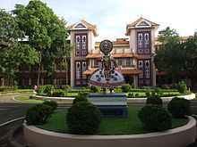 Administrative Block of
Cochin University of Science and Technology
Administrative Block of
Cochin University of Science and Technology
Ernakulam is the first district in India to have 100 percent literacy by 1990. In fact Kochi has the highest literacy rate for any city in the country with over 20 lakhs population.
Pothanikkad
is the first village in India that achieved 100 percent literacy according to state literacy programme is in this district.
[
citation needed
]
There are three prominent universities in Ernakulam:
Sree Sankaracharya University of Sanskrit
in
Kalady
,
Cochin University of Science and Technology
in
Kalamassery
, and
Kerala University of Fisheries and Ocean Studies
in
Kochi
. The district has the most educational institutions in the state; as of 2019, there are 476 fully high-tech schools in Ernakulam.
[16]
In 2017, Ernakulam district administration launched the Roshni project, which aims to provide Malayalam education to migrant children. It supported 1,265 migrant workers’ children from lower primary to high school.
[17]
Divisions
[
edit
]
There are two revenue divisions: Fort Kochi and Muvattupuzha. The municipal corporation is in Kochi.
Taluks
[
edit
]
The district has the most taluks in the state. The district is divided by two revenue divisions with seven taluks.
Municipalities
[
edit
]
Interestingly, Ernakulam district has the most municipalities in the state.
A criticism that has been centered around this fact is that despite municipalities like Aluva, Kalamassery, Thrikkakara, Maradu, Tripunithura and Eloor becoming assimilated into Kochi city, they still exist as individual municipalities instead of being under
Kochi Corporation
. Surprisingly the corporation has not amended its limits for over half a century, since 1967 to be precise. The corporation was the largest in area and population when it was formed, and all these regions were panchayaths back then. Instead of adding them to the corporation when these regions started developing due to the urban expansion of Kochi city, they were made into separate municipalities thus largely handicapping the corporation. Now the call to expand these outdated limits for a better unified administration for the entire city of Kochi is a strong public demand.
[18]
Parliamentary Constituencies
[
edit
]
Assembly Constituencies
[
edit
]
Demographics
[
edit
]
Historical population
| Year
| Pop.
| ±% p.a.
|
|---|
| 1901
| 646,235
| ?
|
|---|
| 1911
| 735,267
| +1.30%
|
|---|
| 1921
| 789,311
| +0.71%
|
|---|
| 1931
| 982,731
| +2.22%
|
|---|
| 1941
| 1,172,292
| +1.78%
|
|---|
| 1951
| 1,393,679
| +1.74%
|
|---|
| 1961
| 1,702,740
| +2.02%
|
|---|
| 1971
| 2,170,820
| +2.46%
|
|---|
| 1981
| 2,549,255
| +1.62%
|
|---|
| 1991
| 2,840,279
| +1.09%
|
|---|
| 2001
| 3,105,798
| +0.90%
|
|---|
| 2011
| 3,282,388
| +0.55%
|
|---|
| 2018
| 3,427,659
| +0.62%
|
|---|
| source:
[19]
|
According to the
2018 Statistics Report
, Ernakulam has a
population
of 3,427,659.
[1]
The
2011 Census of India
reports that the district is ranked 104th most populous in India out of 640.
[5]
The district has a population density of 1,072 inhabitants per square kilometre (2,780/sq mi).
[5]
Its
population growth rate
in 2001?2011 was 5.69%.
[5]
Ernakulam has a
sex ratio
of 1027
females
for every 1000 males,
[5]
and a
literacy rate
of 95.89%. 68.07% of the population lives in urban areas. Scheduled Castes and Scheduled Tribes make up 8.18% and 0.50% of the population respectively.
[5]
Languages of Ernakulam district (2011)
[20]
Others (1.39%)
According to the
2011 census
, 96.70% of the population spoke Malayalam, 0.97% Konkani and 0.94% Tamil as their first language.
[20]
This district is listed as the "most advanced" district in Kerala. It had a resident population of 3,105,798 as of 2001, excluding the commuters from neighbouring districts.
[21]
According to the 2011 Census of India, Ernakulam District also houses the largest city (UA) in the state (17th largest in the country) -
Kochi Urban Agglomeration
. Kochi UA spans across 843km2 with a population of 2,119,724 (2.12 million),
[22]
thereby housing approximately two thirds of the population of Ernakulam District. Government of Kerala have also marked Kochi UA as the only "first order UA" in the state, which has its influence spread across the entire state unlike the other smaller cities.
The district also houses another smaller urban agglomeration -
Kothamangalam
, which has an area of 81.42 km2 housing over 1,14, 639 people. The towns of
Kothamangalam
and
Muvattupuzha
form a major chunk of the Kothamangalam UA.
Religion
[
edit
]
Religions in Ernakulam
| Talukas
|
Hindus
|
Christians
|
Muslims
|
Others
|
| Kunnathunad
|
45.32
|
35.39
|
19.16
|
0.13
|
| Aluva
|
37.78
|
44.64
|
17.29
|
0.29
|
| Paravur
|
56.69
|
28.93
|
14.13
|
0.25
|
| Kochi
|
41.74
|
41.15
|
16.67
|
0.44
|
| Kanayannur
|
53.16
|
34.49
|
11.91
|
0.44
|
| Muvattupuzha
|
40.53
|
45.14
|
14.12
|
0.21
|
| Kothamangalam
|
36.16
|
41.82
|
21.77
|
0.25
|
Hindus
(46%) accounts for the largest community, followed by
Christians
(38%) (
Latin Catholic
,
Syro-Malabar
,
Jacobites
,
Pentecostals
and
Malankara Orthodox
) and
Muslims
(15.7%).
[23]
A small population of
Jains
,
Jews
, and
Sikhs
reside in Kochi.
[24]
Ernakulam once had a vibrant Jewish population, with
several synagogues
, known as the
Malabar Jews
who used to dominate the trade and commercial activities in the district. After the state of Israel was formed in 1945, the entire community made
aliyah
to Israel in the 1950s. Today they number 8000 in Israel but very few Jews remain in the district. After a direct flight service was established between
Kochi
and
Tel Aviv
they have retained ties with the state with annual visits and gatherings.
Ernakulam also has a significant
Konkani Hindu
population who migrated from Goa during the
Goa Inquisition
.
[25]
There is a small
Jain
community in Ernakulam district, concentrated mainly in Kochi city.
[26]
The
Sikh community
in Ernakulam is also concentrated mainly in Kochi. There are more than 25 Sikh families in
Kochi
and there is one
gurdwara
.
[27]
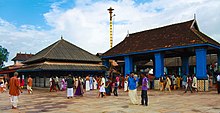
 Thrikkakara Temple
-one of the few temples in India and only temple in Kerala dedicated to
Lord Vamana
Thrikkakara Temple
-one of the few temples in India and only temple in Kerala dedicated to
Lord Vamana
 Chottanikkara Temple
Culture
[
edit
]
Festivals and traditions
[
edit
]
The
Aluva Sivarathri festival
at the
Aluva Mahadeva Temple
(situated on the banks of river Periyar) in Aluva attracts people from around the country.
St. Mary's Orthodox Syrian Cathedral, Piravom
is believed to be founded in 405 A.D. and was the headquarters of
Archdeacon
and St Thomas until the 18th century.
Adi Shankaracharya
was born in
Kalady
, which is considered to be a major pilgrimage centre for
Hindus
around the world.
Kallil Kshethram
is a famous
Jain
temple near
Perumbavoor
.
Puthencruz
is the
regional seat
of
Syriac Orthodox Church
in India, and is where
Saint Thomas Syro-Malabar Catholic Church, Malayattoor
is located.
The eight-day lent (Ettunombu) festival at
St Mary's Jacobite Syrian Valiyapally, Thamarachal
attracts many people from all over the state. St. George Orthodox Syrian Church at Kadamattam near
Muvattupuzha
is very old and was founded by Mar Abo Syrian Metropolitan in the 5th century A.D. He brought a cross from Persia, which is preserved in the church. The festival at the Latin church of Vallarpadam on 24 September attracts people belonging to all religions. The icon of
Virgin Mary
in this church is credited with many miracles.
St. George's Syro-Malabar Catholic Forane Church, Edappally
was founded in 593 A.D.
Important pilgrimage sites in Ernakulam are Koonan Kurish St George Orthodox Pilgrim church,
Mattancherry
; Vadakken Paravoor St Thomas Catholic Church, Malayattoor Pally; and Mor Thoman
Jacobite Church
,
Kothamangalam
; and
Thrikkunnathu St Mary's Seminary Church, Aluva
. The relics of
Gregorios Abdul Jaleel
are preserved at the St. Thomas Jacobite church
North Paravur
. Thousands of pilgrims from Kerala culminate on 27 April for the Dhukrono of the Saint. The Feast of
Eldho Mor Baselios
is celebrated in the tomb church Mor Thoman Church at Kothamangalam every year on 2 and 3 October. The Feast of
Paulose Mar Athanasius
on 26 January at
Thrikkunnathu St Mary's Seminary Church, Aluva
, where he is entombed, also attracts thousands.
Gheevarghese Mar Gregorios of Parumala
, also known as
Parumala Thirumeni
, the first saint of
Malankara Orthodox Syrian Church
from India was born and brought up in
Mulanthuruthy
.
Places of interest
[
edit
]
- Marine Drive, Kochi
- Kadavumbhagam Mattancherry Synagogue
- Kadavumbhagam Ernakulam Synagogue
- Paradesi Synagogue
: Constructed in 1567, only active
synagogue
in the Kochi.
- Chinese Fishing Nets
(Cheena Vala)
- Hill Palace, Tripunithura
- Bolgatty Island
- Willingdon Island
- Dutch Palace
: Made in 1568 by the Portuguese. Later re-structured by the Dutch.
- St. Francis Church, Kochi
: Originally built in 1503, the oldest European church in India
- Kodanad
: Elephant training centre is located here.
- Pareekshit Thampuran Museum
- Kerala Historical Museum
: Located at
Edappally
- Chendamangalam
, a village
- Palium Palace
- Vypeenakotta Seminary
- Bhoothathankettu
, a scenic dam site
- St. Thomas Syro-Malabar Catholic Church, Malayattoor
: The only international shrine in Asia. Believed to have been visited by St. Thomas, the apostle.
- Wonder La
, Kakkanad: Amusement park
- Cherai Beach
.
- Kuzhippilly Beach
[28]
- Fort Kochi Beach
- Paniyeli Poru
- Ezhattumugham
Transport
[
edit
]
Road connectivity
[
edit
]
The three major national highways passing through Ernakulam are the Cochin-Mumbai Highway (
NH 66
), Salem-Kanyakumari (
NH 47
part of
NSEW corridor
), and Cochin-Dhanushkodi highway (
NH 49
).
Railway station
[
edit
]
Ernakulam has 17 railway stations. The
Ernakulam Junction
,
Ernakulam Town
and
Aluva
are the major stations. The other stations are
Angamaly
,
Thripunithura
,
Edapally
,
Mulamthuruthy
,
Cochin Harbour Terminus
, Karakutty,
Chowara
,
Kalamassery
,
Nettoor
,
Kumbalam
,
Mattancherry H.
, Chottanikkara road,
Kanjiramattom
and
Piravom
road. The rail routes travel via
Thrissur
, Kottayam, Cochin H.T.,
Alappuzha
, and Vallarpadam. The Angamaly-Erumely Sabarimala route passes through the district.
Kochi Metro
runs in Kochi.
Airport
[
edit
]
Ernakulam district has two airports: Naval airport in W.island (Old Cochin airport) and
Cochin International Airport
(CIAL). CIAL is the fourth largest airport in the country after
Mumbai
,
Delhi
, and
Chennai
, and serves International passengers.
Water transport
[
edit
]
Ernakulam lies in the flat delta region of the Periyar and Moovattupuzha rivers. Water transport is prominent in the district via rivers and lagoons.
Notable people
[
edit
]
Gallery
[
edit
]
-
-
-
Chinese Net Bridge at Marine Drive walkway
-
The old Dutch cemetery in Kochi
-
School in Old Kochi
-
Fishing nets in Fort Kochi
-
-
-
Heritage Building of Ernakulam District Court
See also
[
edit
]
References
[
edit
]
- ^
a
b
Annual Vital Statistics Report - 2018
(PDF)
. Thiruvananthapuram: Department of Economics and Statistics, Government of Kerala. 2020. p. 55. Archived from
the original
(PDF)
on 2 November 2021
. Retrieved
30 October
2020
.
- ^
"Demography -Ernakulam"
(PDF)
. Directorate of Census Operations, Kerala
. Retrieved
4 July
2020
.
- ^
"Kerala | UNDP in India"
.
UNDP
.
- ^
Pilgrimate to Temple Heritage 2019: Ernakulam district temples
. Info Kerala Communications Pvt Ltd, 2019. 2019.
ISBN
9788193456781
. Retrieved
2 October
2020
.
- ^
a
b
c
d
e
f
"District Census Hand Book: Ernakulam"
(PDF)
.
Census of India
.
Registrar General and Census Commissioner of India
.
- ^
"Ernakulam to be declared first district with 100% banking"
.
The Hindu Businessline
. 15 November 2012. Archived from
the original
on 1 February 2013
. Retrieved
27 February
2013
.
- ^
Soundarapandian, Mookkiah (2000).
Literacy Campaign in India
. New Delhi: Discovery Publishing House. p. 21.
ISBN
9788171415533
.
- ^
"Kerala"
.
UNDP in India
. Retrieved
10 October
2019
.
- ^
The Portuguese, Indian Ocean and European Bridgeheads 1500?1800
. Festschrift in Honour of Prof. K. S. Mathew (2001). Edited by: Pius Malekandathil and T. Jamal Mohammed. Fundacoa Oriente. Institute for Research in Social Sciences and Humanities of MESHAR (Kerala)
- ^
M K Sunil Kumar (26 September 2017).
"50 years on, Kochi still has a long way to go"
.
The Times of India
. Retrieved
1 June
2021
.
- ^
"Mangalavanam Bird Sanctuary"
.
Kerala Tourism Development Corporation
. Retrieved
21 January
2018
.
- ^
"Green Lung of Kochi"
. cochin.org
. Retrieved
3 April
2016
.
- ^
"Mangalavanam Bird Sanctuary"
. Kochi Servnet. Archived from
the original
on 23 September 2016
. Retrieved
12 November
2015
.
- ^
"Kochi, India"
. Whetherbase. August 2011
. Retrieved
1 July
2010
.
- ^
"Kochi, India"
. MSN India. Archived from
the original
on 14 July 2011
. Retrieved
3 August
2010
.
- ^
"Now, Ernakulam has 476 fully high-tech schools"
.
The Hindu
. 7 December 2019 – via www.thehindu.com.
- ^
Shreehari Paliath, IndiaSpend com.
"In Kerala's Ernakulam district, a programme is helping migrant children stay in school"
.
Scroll.in
.
- ^
"Chamber calls for expansion of Kochi Corp - The New Indian Express"
.
- ^
"Census of India Website : Office of the Registrar General & Census Commissioner, India"
.
www.censusindia.gov.in
.
- ^
a
b
"Table C-16 Population by Mother Tongue: Kerala"
.
www.censusindia.gov.in
.
Registrar General and Census Commissioner of India
.
- ^
"censusindia.gov.in"
(PDF)
.
- ^
"????? ?? ???? ????? ????????, ???? ?????"
. Mohua.gov.in
. Retrieved
7 May
2022
.
- ^
a
b
"Table C-01: Population by religious community: Kerala"
.
Census of India
.
Registrar General and Census Commissioner of India
. 2011.
- ^
Official Ernakulam District Profile
Archived
21 July 2011 at the
Wayback Machine
- ^
"Exploring Kochi through a Goan lens"
.
The New Indian Express
.
- ^
"Jain festival celebrated in city | Kochi News - Times of India"
.
The Times of India
.
- ^
"Sikh families: The Sikhs here love Kochi | Kochi News - Times of India"
.
The Times of India
.
- ^
"Kuzhupilly Beach"
.
www.kuzhupillybeach.com
.
Further reading
[
edit
]
- U. Sivaraman Nair (1952),
1951 Census Handbook- Trichur District
(PDF)
, Trivandrum: Travancore-Cochin Government Press
- M. K. Devassy (1965),
1961 Census Handbook- Ernakulam District
(PDF)
, Directorate of Census Operations, Kerala and The Union Territory of Laccadive, Minicoy, and Amindivi Islands
- Government of India (2014?15),
District Census Handbook - Ernakulam (Part-A) 2011
(PDF)
, Directorate of Census Operations, Kerala
- Government of India (2014?15),
District Census Handbook - Ernakulam (Part-B) 2011
(PDF)
, Directorate of Census Operations, Kerala
External links
[
edit
]
Places adjacent to Ernakulam district
|
|---|
|
Articles Related to Ernakulam district
|
|---|
|
|---|
Cities
and
towns
| |
|---|
Sub-districts
and
villages
| |
|---|
|
|---|
| Landmarks
| |
|---|
| Neighbourhoods
| |
|---|
| History
| |
|---|
| Transport
| |
|---|
| Government
| |
|---|
| Organizations
| |
|---|
| Malls
| |
|---|
| Culture
| |
|---|
| Places of worship
| |
|---|
| Health care
| |
|---|
| Schools
| |
|---|
| Universities
| |
|---|
| Roads
| |
|---|
| Sports
| |
|---|
| Press
| |
|---|
| Television channels
| |
|---|
|
|---|
| Districts
| | |
|---|
Towns and
cities
| |
|---|
|