"East Ontario" redirects here. For the train station in Ontario, California, United States, see
Ontario?East station
.
Secondary region in Ontario, Canada
Eastern Ontario
Est de l'Ontario
(
French
)
|
|---|
|
 |
| Country
|  Canada Canada
|
|---|
| Province
|  Ontario Ontario
|
|---|
|
| ? Total
| 34,356.45 km
2
(13,265.09 sq mi)
|
|---|
| ? Core
| 28,014.95 km
2
(10,816.63 sq mi)
|
|---|
| ? Extended area
| 6,341.50 km
2
(2,448.46 sq mi)
|
|---|
|
| ? Total
| 1,892,332
|
|---|
| ? Density
| 55/km
2
(140/sq mi)
|
|---|
| ? Core
| 1,720,882
|
|---|
| ? Extended area
| 171,450
|
|---|
| Time zone
| UTC?5
(
EST
)
|
|---|
| ? Summer (
DST
)
| UTC?4
(EDT)
|
|---|
| Postal code prefixes
| |
|---|
| Area codes
| 613/343
|
|---|
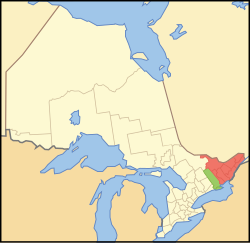
Eastern Ontario
(census population 1,892,332 in 2021) (
French
:
Est de l'Ontario
) is a secondary region of
Southern Ontario
in the
Canadian province
of
Ontario
. It occupies a wedge-shaped area bounded by the
Ottawa River
and
Quebec
to the northeast and east, the
St. Lawrence River
and
New York
to the south, and
Northern Ontario
and
Central Ontario
to the west and northwest.
Definitions
[
edit
]
The traditional definition of the region boundary can be traced back to early colonial districts in the
British Province of Quebec
and
Upper Canada
. The
Midland
and
Eastern Districts
, originally known as the
Mecklenburg District
and
Lunenburg District,
from 1788 to 1792,
[1]
were originally designated as everything east of north-south lines intersecting the outlets of the
Trent River
into the
Bay of Quinte
(in the case of Mecklenburg/Midland) and the
Gananoque River
into the
St. Lawrence River
(in the case of Lunenberg/Eastern).
[2]
The original boundary lines followed a straight north-south alignment, but were eventually changed to a northwest-southeast orientation, similar to how the modern county boundaries are aligned.
Some government sources may include
Hastings County
,
Prince Edward
(considered part of the Eastern Ontario extended area), and occasionally
Northumberland County
within the definition of Eastern Ontario, but are otherwise classified as part of
Central Ontario
.
The region is also occasionally referred to as
Southeastern Ontario
to differentiate it from
Northeastern Ontario
, a secondary region of
Northern Ontario
.
History
[
edit
]
 Ottawa
French explorers and
fur traders
were the first recorded Europeans to pass through this region.
Samuel de Champlain
, explorer, traversed the
Ottawa River
in 1615 on his way westward to the
Great Lakes
. The largest city in the region is the city of
Ottawa
, capital of Canada, which accounts for roughly 60% of Eastern Ontario's population.
Kingston
, itself once capital of the
Province of Canada
, is another city in the region outside of the
National Capital Region
.
Much of the remainder of the region relies on
agriculture
and tourism. Heavier reliance on recreation and tourism exists in the more rugged Renfrew county in the northwest of Eastern Ontario.
Of all Ontario's regions, parts of Eastern Ontario are the most heavily influenced by the
United Empire Loyalists
, American settlers who moved to
Upper Canada
out of loyalty to the
British
Crown during and after the
American Revolutionary War
. The Loyalist influence has a presence in the counties of Stormont, Dundas, Leeds and Grenville, Frontenac, Hastings, and Prince Edward.
In Ottawa, Prescott and Russell, Glengarry, and Renfrew, Eastern Ontario is home to the largest
Franco-Ontarian
community within Ontario.
Extensive immigration by
Scottish Highlanders
from the Highland land clearances also took place around the time of the United Empire Loyalist migration. After the Loyalist period, more waves of Highland emigration came primarily from
Inverness-shire
,
Scotland
to seek a better quality of life. The majority of these Scottish immigrants settled in the specific Highland community
Glengarry County
. Large numbers of Irish Catholics, mainly from
Cork
and surrounding counties also settled in the area in the decades following the War of 1812, the majority of them in or near present-day Ottawa in Carleton, Dundas, Grenville, and Renfrew Counties. Many arrived through government backed immigration schemes to settle unoccupied lands and fill labour shortages. Along with the
Franco-Ontarians
in particular, they made up the majority of canal builders on the large
Rideau Canal
project and were heavily employed in the area's extensive
lumber industry
.
Through the last century, newer immigrant groups, both Francophone and non-Francophone, have added to the cultural diversity, mostly in Ottawa. There are a large number of Francophones in Eastern Ontario, especially in Prescott and Russell United Counties. Following the
Second World War
, there was a massive influx of Dutch immigrants to Canada, with many settling in communities in Eastern Ontario, particularly in Dundas, Stormont, and Grenville.
Demographics
[
edit
]
Population
[
edit
]
| Census Region
|
Population
(2021)
[3]
|
Population
(2016)
[3]
|
Population
(2011)
[3]
|
Population
(2006)
[3]
|
Population
(2001)
[3]
|
Area
(km
2
)
[3]
|
| Ottawa (Ontario)
|
1,017,449
|
934,243
|
883,391
|
812,129
|
774,072
|
2,790.31
|
| Frontenac
|
161,780
|
150,475
|
149,738
|
143,865
|
138,606
|
3,336.62
|
| Hastings*
|
145,746
|
136,445
|
134,934
|
130,474
|
125,915
|
5,291.05
|
| Stormont, Dundas and Glengarry
|
114,637
|
113,429
|
111,164
|
110,399
|
109,522
|
3,309.87
|
| Renfrew
|
106,365
|
102,394
|
101,326
|
97,545
|
95,138
|
7,357.94
|
| Leeds and Grenville
|
104,070
|
100,546
|
99,306
|
99,206
|
96,606
|
3,350.08
|
| Prescott and Russell
|
95,639
|
89,333
|
85,381
|
80,184
|
76,446
|
2,004.47
|
| Lanark
|
75,760
|
68,698
|
65,667
|
63,785
|
62,495
|
3,025.98
|
| Lennox and Addington
|
45,182
|
42,888
|
41,824
|
40,542
|
39,461
|
2,839.68
|
| Prince Edward*
|
25,704
|
24,735
|
25,258
|
25,496
|
24,901
|
1,050.45
|
| Total
|
1,720,882
|
1,602,006
|
1,537,797
|
1,447,655
|
1,392,376
|
28,014.95
|
| Total *(incl ext. area)
|
1,892,332
|
1,763,186
|
1,697,989
|
1,603,625
|
1,543,192
|
34,356.45
|
Census Metropolitan Areas
[
edit
]
| Metropolitan Area
|
Type
|
Population
[4]
[5]
|
Change
|
Land Area
(km
2
)
[4]
|
Population
Density (/km
2
)
|
| (2023) Estimate
|
(2021)
|
(2016)
|
| Ottawa-Gatineau
|
CMA
|
1,609,805
|
1,488,307
|
1,371,576
|
+8.51%
|
8046.99
|
185.0
|
| Ottawa (Ontario)
|
CMA
|
1,244,997
|
1,017,449
|
934,243
|
+8.90%
|
2,790.31
|
364.7
|
| Kingston
|
CMA
|
188,267
|
172,546
|
161,175
|
+7.06%
|
1919.17
|
89.9
|
| Belleville
-
Quinte West
*
|
CMA
|
121,982
|
111,184
|
103,401
|
+7.53%
|
1337.50
|
83.1
|
| Cornwall
|
CA
|
66,351
|
61,415
|
59,699
|
+2.87%
|
509.21
|
120.6
|
| Brockville
|
CA
|
33,649
|
31,661
|
31,200
|
+1.48%
|
576.87
|
54.9
|
| Pembroke
|
CA
|
25,068
|
23,814
|
23,269
|
+2.34%
|
553.40
|
43.0
|
| Petawawa
|
CA
|
19,464
|
18,160
|
17,187
|
+5.66%
|
164.70
|
110.3
|
| Hawkesbury
|
CA
|
12,668
|
12,010
|
11,974
|
+0.30%
|
12.91
|
930.3
|
| Hawkesbury (Ontario)
|
CA
|
10,747
|
10,194
|
10,263
|
?0.67%
|
10.00
|
1019.4
|
Administrative Divisions
[
edit
]
Single-Tier Municipalities
[
edit
]
Separated Municipalities
[
edit
]
Counties
[
edit
]
Geography
[
edit
]
 Thousand Islands
in the
St. Lawrence River
Thousand Islands
in the
St. Lawrence River
Eastern Ontario is located within both the
Mixedwood Plains Ecozone
(as classified by Environment and Climate Change Canada, further subclassified into the St. Lawrence Lowland, Frontenac Axis, Manitoulin-Lake Simcoe regions),
[6]
and
Boreal Shield Ecozone
(further subclassified into the Algonquin-Lake Nipissing region).
[7]
Surficial geology largely consists of
glacial till
,
glaciolacustrine
and
glaciomarine
silt
/
clay
plains, and low-lying
wetlands
underlain by
sedimentary
limestone
,
dolostone
,
siltstone
,
sandstone
,
arkose
, and
shale
bedrock, in addition to sections of
plutonic igneous
granite
,
quartz
,
gneiss
, and
conglomerate
bedrock of the
Canadian Shield
, which is exposed at the surface in many locations. Eastern Ontario's geography is highly varied, with flat plains and rolling hills in the eastern section of the region, near the
St. Lawrence River
and
Lake Ontario
, and rugged
highland
areas in the sections that the Canadian Shield covers, including the
Laurentian Highlands
and
Openogo Hills
, ranging from
Algonquin Provincial Park
south toward Lake Ontario. The
Thousand Islands
region is a unique bedrock
archipelago
in the St. Lawrence River that consists of approximately 1,864 islands straddling the
Canada-US border
. Geological fault zones run through the region, including the
Western Quebec Seismic Zone
and the
St. Lawrence Rift System
. These fault zones result in a
graben
(
Ottawa-Bonnechere Graben
) that forms the
Ottawa Valley
, running the length of the
Ottawa River
and
Mattawa River
north to
Lake Nipissing
. Subsequently, the region is prone to
sinkholes
[8]
and
earthquakes
. More severe earthquakes (
Richter Magnitude scale
of 5-6 or greater) occur at a frequency of approximately 60 years on average. The most recent severe earthquake to occur, the
2010 Central Canada Earthquake
, caused minor damage to power grid systems and buildings in
Ottawa
and other nearby areas.
[9]
Additional major historical earthquakes include the
1944 Cornwall-Massena Earthquake
.
 Algonquin Provincial Park
Eastern Ontario maintains significant forest coverage, predominantly in the areas of the Canadian Shield that could not be cleared for agricultural purposes. A singular forest region is located in Eastern Ontario,
[10]
known as the
Great Lakes-St. Lawrence forest
.
[11]
The historical prominence of the
logging
industry has resulted in significant historical clearing of these forests, but the implementation of more sustainable
forestry
practices and governmental protections on certain areas has resulted in regrowth and retention of forests on areas not suitable for agriculture. One major federally protected area,
Thousand Islands National Park
, is located in Eastern Ontario. Multiple provincial parks are also located in the region, with the most significant of which being
Algonquin Provincial Park
, itself established to encourage sustainable forestry practices after being
clearcut
in the late 19th century.
[12]
Climate
[
edit
]
 Koppen Climate Map
of Ontario
Koppen Climate Map
of Ontario
Eastern Ontario's climate is heavily influenced by the proximity of the
Great Lakes
and its relative northern latitude compared to other parts of
Southern Ontario
. Winters in the region are typically severe, with regions experiencing low temperatures and significant amounts of snow and ice during winter months.
Highland
regions experience more severe winters due to their higher elevation. Significant snowfall is common in the area even into the spring.
[13]
Summers are typically hot and humid in lower-lying areas, with milder and cooler summers occurring in the north. Eastern Ontario also experiences
ice storms
on a regular basis due to the presence of the
arctic
high-pressure system
,
[14]
heavily impacting the low-lying areas of the
Ottawa Valley
and
St. Lawrence Valley
, with significant events including the
1998 North American Ice Storm
and the
2023 Canadian Ice Storm
. Eastern Ontario also regularly experiences severe weather events, including
tornadoes
, and
thunderstorms
as a result of humid summer temperatures.
Under the
Koppen climate classification
, Eastern Ontario has a
humid continental climate
, with the entire area experiencing a warm-summer
Dfb
climate
.
Temperatures are warmer along the north shore of
Lake Ontario
and the St. Lawrence River, in areas such as
Prince Edward County
, in comparison to the more northern areas of the region.
Education
[
edit
]
 Queen's University
in
Kingston
Queen's University
in
Kingston
Eastern Ontario has multiple
tertiary
education institutions in the form of both
universities
and
colleges
. Two universities,
University of Ottawa
and
Queen's University
, are part of the
U15 Group
, the association of Canada's dominant research universities.
Universities
[
edit
]
Colleges
[
edit
]
References
[
edit
]
- ^
"The Changing Shape of Ontario: Early Districts and Counties 1788-1899"
.
www.archives.gov.on.ca
. Retrieved
2024-04-14
.
- ^
Ontario (1831).
Proclamation of July 4, 1788
.
- ^
a
b
c
d
e
f
"Census Mapper (Canada Census 2021, 2016, 2011, 2006, 2001)"
.
Census Mapper
. Retrieved
2024-03-31
.
- ^
a
b
Government of Canada, Statistics Canada (2022-02-09).
"Population and dwelling counts: Census metropolitan areas, census agglomerations and census subdivisions (municipalities)"
.
www150.statcan.gc.ca
. Retrieved
2024-03-31
.
- ^
Government of Canada, Statistics Canada (2024-05-22).
"Population estimates, July 1, by census metropolitan area and census agglomeration, 2021 boundaries"
.
www150.statcan.gc.ca
. Retrieved
2024-05-22
.
- ^
"Mixedwood Plains Ecozone"
.
www.ecozones.ca
. Retrieved
2024-03-31
.
- ^
"Boreal Shield Ecozone"
.
www.ecozones.ca
. Retrieved
2024-05-28
.
- ^
"Massive sinkhole closes Rideau Street in downtown Ottawa"
.
CBC News
. June 8, 2016.
{{
cite news
}}
: CS1 maint: url-status (
link
)
- ^
"Earthquake of 5.0 magnitude rattles residents across Ontario and Quebec"
.
CP24
. 2010-06-23
. Retrieved
2024-05-28
.
- ^
"Forest regions | ontario.ca"
.
www.ontario.ca
. Retrieved
2024-03-31
.
- ^
"The Great Lakes?St. Lawrence forest; highly valued woodlands"
.
www.the-forest-time.com
. Retrieved
2024-03-31
.
- ^
"Death on a Painted Lake: The Tom Thomson Tragedy"
.
www.canadianmysteries.ca
. Retrieved
2024-05-28
.
- ^
"Not an April Fool's joke: Up to 25 cm of snow forecast in Ottawa this week"
.
Ottawa Citizen
. April 1, 2024.
{{
cite news
}}
: CS1 maint: url-status (
link
)
- ^
"Severe Ice Storm Risks in Ontario"
(PDF)
.
Institute for Catastrophic Loss Reduction
. November 2004.
External links
[
edit
]
Places adjacent to Eastern Ontario
|
|---|
|
45°N
75°W
/
45°N 75°W
/
45; -75