Strong surface-level winds that radiate from a single point
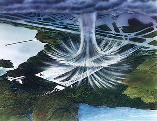 Illustration of a microburst at an airport. The air moves in a downward motion until it hits the surface. It then spreads outward in all directions. The wind regime in a microburst is opposite to that of a tornado.
In
meteorology
, a
downburst
is a strong downward and outward gushing
wind
system that emanates from a point source above and blows
radially
, that is, in straight lines in all directions from the area of impact at surface level. It originates under deep, moist convective conditions like
Cumulus congestus
or
Cumulonimbus
. Capable of producing damaging winds, it may sometimes be confused with a
tornado
, where high-velocity winds circle a central area, and air moves inward and upward. These usually last for seconds to minutes. Downbursts are particularly strong
downdrafts
within thunderstorms (or deep, moist convection as sometimes downbursts emanate from
cumulonimbus
or even
cumulus congestus
clouds that are not producing
lightning
).
Downbursts are most often created by an area of significantly
precipitation
-cooled air that, after reaching the surface (
subsiding
), spreads out in all directions producing strong winds.
Dry downbursts
are associated with
thunderstorms
that exhibit very little rain, while
wet downbursts
are created by thunderstorms with significant amounts of precipitation.
[1]
Microbursts
and
macrobursts
are downbursts at very small and larger scales, respectively. A rare variety of dry downburst, the
heat burst
, is created by vertical
currents
on the backside of old
outflow boundaries
and
squall lines
where rainfall is lacking. Heat bursts generate significantly higher temperatures due to the lack of rain-cooled air in their formation and compressional heating during descent.
Down bursts are a topic of notable discussion in
aviation
, since they create vertical
wind shear
, which has the potential to be dangerous to
aviation
, especially during
landing
(or
takeoff
), where airspeed performance windows are the most narrow. Several fatal and historic
crashes
in past decades are attributed to the phenomenon and
flight crew
training goes to great lengths on how to properly recognize and recover from a downburst/wind shear event; wind shear recovery, among other adverse weather events, are standard topics across the world in
flight simulator
training that flight crews receive and must successfully complete.
Detection
and
nowcasting
technology was also implemented in much of the world and particularly around major airports, which in many cases actually have wind shear detection equipment on the field. This detection equipment helps
air traffic controllers
and pilots make decisions on the safety and feasibility of operating on or in the vicinity of the airport during storms.
[2]
Definition
[
edit
]
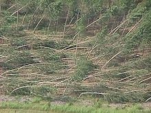 Downburst damages in a straight line
A downburst is created by a column of sinking air that after hitting the surface spreads out in all directions and is capable of producing damaging straight-line winds of over 240 km/h (150 mph), often producing damage similar to, but distinguishable from, that caused by tornadoes.
[1]
Downburst damage radiates from a central point as the descending column spreads out when hitting the surface, whereas tornado damage tends towards convergent damage consistent with rotating winds. To differentiate between tornado damage and damage from a downburst, the term
straight-line winds
is applied to damage from microbursts.
Downbursts in air that is precipitation free or contains
virga
are known as
dry downbursts
;
[3]
those accompanied with precipitation are known as
wet downbursts
. These generally are formed by precipitation-cooled air rushing to the surface, but they perhaps also could be powered by strong winds aloft being deflected toward the surface by dynamical processes in a thunderstorm (see
rear flank downdraft
).
[
citation needed
]
Most downbursts are less than 4 km (2.5 mi) in extent: these are called
microbursts
.
[4]
Downbursts larger than 4 km (2.5 mi) in extent are sometimes called
macrobursts
.
[4]
Downbursts can occur over large areas. In the extreme case, a series of continuing downbursts results in a
derecho
, which covers huge areas of more than 320 km (200 mi) wide and over 1,600 km (1,000 mi) long, persisting for 12 hours or more, and which is associated with some of the most intense straight-line winds.
[5]
The term
microburst
was defined by
mesoscale meteorology
expert
Ted Fujita
as affecting an area 4 km (2.5 mi) in diameter or less, distinguishing them as a type of downburst and apart from common wind shear which can encompass greater areas.
[6]
Fujita also coined the term macroburst for downbursts larger than 4 km (2.5 mi).
[7]
Dry microbursts
[
edit
]
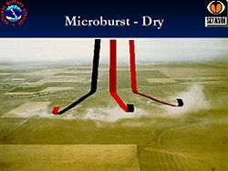 Dry microburst schematic
When rain falls below the
cloud base
or is mixed with dry air, it begins to evaporate and this
evaporation
process cools the air. The denser cool air descends and accelerates as it approaches the surface. When the cool air approaches the surface, it spreads out in all directions. High winds spread out in this type of pattern showing little or no curvature are known as straight-line winds.
[8]
Dry microbursts are typically produced by high based thunderstorms that contain little to no surface rainfall. They occur in environments characterized by a thermodynamic profile exhibiting an inverted-V at thermal and moisture profile, as viewed on a
Skew-T log-P thermodynamic diagram
.
Wakimoto
(1985) developed a conceptual model (over the
High Plains
of the United States) of a dry microburst environment that comprised three important variables: mid-level moisture, cloud base in the mid troposphere, and low surface
relative humidity
. These conditions evaporate the moisture from the air as it falls, cooling the air and making it fall faster because it is more dense.
Wet microbursts
[
edit
]
 A wet microburst
Wet microbursts are downbursts accompanied by significant precipitation at the surface.
[9]
These downbursts rely more on the drag of precipitation for downward acceleration of
parcels
as well as the negative
buoyancy
which tend to drive "dry" microbursts. As a result, higher
mixing ratios
are necessary for these downbursts to form (hence the name "wet" microbursts). Melting of ice, particularly
hail
, appears to play an important role in downburst formation (Wakimoto and Bringi, 1988), especially in the lowest 1 km (0.6 mi) above surface level (Proctor, 1989). These factors, among others, make
forecasting
wet microbursts difficult.
| Characteristic
|
Dry Microburst
|
Wet Microburst
|
| Location of highest probability within the United States
|
Midwest
/
West
|
Southeast
|
| Precipitation
|
Little or none
|
Moderate or heavy
|
| Cloud bases
|
As high as 500 hPa (mb)
|
As high as 850 hPa (mb)
|
| Features below cloud base
|
Virga
|
Precipitation shaft
|
| Primary catalyst
|
Evaporative cooling
|
Precipitation loading and evaporative cooling
|
| Environment below cloud base
|
Deep dry layer/low relative humidity/dry adiabatic lapse rate
|
Shallow dry layer/high relative humidity/moist adiabatic lapse rate
|
Straight-line winds
[
edit
]
Straight-line winds
(also known as
plough winds
,
thundergusts
, and
hurricanes of the prairie
) are very strong winds that can produce damage, demonstrating a lack of the rotational damage pattern associated with tornadoes.
[10]
Straight-line winds are common with the
gust front
of a thunderstorm or originate with a downburst from a thunderstorm. These events can cause considerable damage, even in the absence of a tornado. The winds can gust to 58 m/s (130 mph)
[11]
and winds of 26 m/s (58 mph) or more can last for more than twenty minutes.
[12]
In the United States, such straight-line wind events are most common during the spring when instability is highest and weather fronts routinely cross the country.
[
citation needed
]
Straight-line wind events in the form of derechos can take place throughout the eastern half of the U.S.
[13]
Straight-line winds may be damaging to marine interests. Small ships, cutters and sailboats are at risk from this meteorological phenomenon.
[
citation needed
]
Formation
[
edit
]
The formation of a downburst starts with
hail
or large
raindrops
falling through drier air.
Hailstones
melt and raindrops evaporate, pulling
latent heat
from surrounding air and cooling it considerably. Cooler air has a higher density than the warmer air around it, so it sinks to the surface. As the cold air hits the ground or water it spreads out and a mesoscale
front
can be observed as a
gust front
. Areas under and immediately adjacent to the downburst are the areas which receive the highest winds and rainfall, if any is present. Also, because the rain-cooled air is descending from the middle troposphere, a significant drop in temperatures is noticed. Due to interaction with the surface, the downburst quickly loses strength as it fans out and forms the distinctive "curl shape" that is commonly seen at the periphery of the microburst (see image). Downbursts usually last only a few minutes and then dissipate, except in the case of squall lines and derecho events. However, despite their short lifespan, microbursts are a serious hazard to aviation and property and can result in substantial damage to the area.
Downbursts go through three stages in their cycle: the downburst, outburst, and cushion stages.
[14]
Development stages of microbursts
[
edit
]
The evolution of microbursts is broken down into three stages: the contact stage, the outburst stage, and the cushion stage:
[15]
- A downburst initially develops as the downdraft begins its descent from the cloud base. The downdraft accelerates, and within minutes reaches the surface (contact stage).
- During the outburst stage, the wind "curls" as the cold air of the downburst moves away from the point of impact with the surface.
- During the cushion stage, winds about the curl continue to accelerate, while the winds at the surface slow due to friction.
On a
weather radar
Doppler display, a downburst is seen as a couplet of radial winds in the outburst and cushion stages. The rightmost image shows such a display from the
ARMOR Doppler Weather Radar
in Huntsville, Alabama in 2012. The radar is on the right side of the image and the downburst is along the line separating the velocity towards the radar (green), and the one moving away (red).
Physical processes of dry and wet microbursts
[
edit
]

Basic physical processes using simplified buoyancy equations
[
edit
]
Start by using the
vertical momentum equation
:

By decomposing the variables into a basic state and a
perturbation
, defining the basic states, and using the
ideal gas law
(
 ), then the equation can be written in the form

where B is
buoyancy
. The
virtual temperature
correction usually is rather small and to a good approximation; it can be ignored when computing buoyancy. Finally, the effects of precipitation loading on the vertical motion are
parametrized
by including a term that decreases buoyancy as the liquid water mixing ratio (
 ) increases, leading to the final form of the parcel's momentum equation:

The first term is the effect of perturbation pressure gradients on vertical motion. In some storms this term has a large effect on
updrafts
(Rotunno and Klemp, 1982) but there is not much reason to believe it has much of an impact on
downdrafts
(at least to a first approximation) and therefore will be ignored.
The second term is the effect of buoyancy on vertical motion. Clearly, in the case of microbursts, one expects to find that B is negative meaning the parcel is cooler than its environment. This cooling typically takes place as a result of
phase changes
(
evaporation
,
melting
, and
sublimation
). Precipitation particles that are small, but are in great quantity, promote a maximum contribution to cooling and, hence, to creation of negative buoyancy. The major contribution to this process is from evaporation.
The last term is the effect of water loading. Whereas evaporation is promoted by large numbers of small droplets, it only requires a few large
drops
to contribute substantially to the downward acceleration of air parcels. This term is associated with storms having high precipitation rates. Comparing the effects of water loading to those associated with buoyancy, if a parcel has a liquid water mixing ratio of 1.0
g
kg
?1
, this is roughly equivalent to about 0.3
K
of negative buoyancy; the latter is a large (but not extreme) value. Therefore, in general terms, negative buoyancy is typically the major contributor to downdrafts.
[16]
Negative vertical motion associated only with buoyancy
[
edit
]
Using pure "parcel theory" results in a prediction of the maximum downdraft of

where NAPE is the negative
available potential energy
,

and where LFS denotes the level of free sink for a descending parcel and SFC denotes the surface. This means that the maximum downward motion is associated with the
integrated
negative buoyancy. Even a relatively modest negative buoyancy can result in a substantial downdraft if it is maintained over a relatively large depth. A downward speed of 25 m/s (56 mph; 90 km/h) results from the relatively modest NAPE value of 312.5 m
2
s
?2
. To a first approximation, the maximum gust is roughly equal to the maximum downdraft speed.
[16]
Heat bursts
[
edit
]
A special, and much rarer, kind of downburst is a
heat burst
, which results from precipitation-evaporated air compressionally heating as it descends from very high altitude, usually on the backside of a dying squall line or outflow boundary.
[17]
Heat bursts are chiefly a nocturnal occurrence, can produce winds over 160 km/h (100 mph), are characterized by exceptionally dry air, can suddenly raise the surface temperature to 38 °C (100 °F) or more, and sometimes persist for several hours.
Danger to aviation
[
edit
]
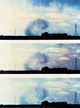 A series of photographs of the surface curl soon after a microburst impacted the surface
Downbursts, particularly microbursts, are exceedingly dangerous to aircraft which are taking off or landing due to the strong vertical wind shear caused by these events. Several fatal crashes are attributed to downbursts.
[18]
The following are some fatal crashes and/or aircraft incidents that have been attributed to microbursts in the vicinity of airports:
- 1950 Air France multiple Douglas DC-4 accidents
,
Douglas DC-4
(F-BBDE and F-BBDM),
Bahrain International Airport
- 12 and 14 June 1950
[19]
- 1956 Kano Airport BOAC Argonaut crash
,
Canadair C-4 Argonaut
(G-ALHE),
Kano Airport
? 24 June 1956
[20]
- Malev Flight 731
,
Ilyushin Il-18
(HA-MOC),
Copenhagen Airport
? 28 August 1971
[21]
- Ozark Air Lines Flight 809
,
Fairchild F-27
(N4215),
St. Louis International Airport
- 23 July 1973
[22]
- Pan Am Flight 806
,
Boeing 707
(N454PA),
Pago Pago International Airport
- 30 January 1974
[23]
- Eastern Air Lines Flight 66
,
Boeing 727
(N8845E),
John F. Kennedy International Airport
? 24 June 1975
[18]
- Continental Airlines
Flight 426,
Boeing 727
(N88777),
Stapleton International Airport
- 7 August 1975
[24]
- Allegheny Airlines
Flight 121,
Douglas DC-9
(N994VJ),
Philadelphia International Airport
- 23 June 1976
[25]
- Continental Airlines
Flight 63,
Boeing 727
(N32725),
Tucson International Airport
- 3 June 1977
[26]
- Aeroflot Flight 4225
,
Tupolev Tu-154
(CCCP-85355),
Almaty International Airport
- 8 July 1980
[27]
- Pan Am Flight 759
,
Boeing 727
(N4737),
New Orleans International Airport
? 9 July 1982
[18]
- USAir
Flight 183,
McDonnell Douglas DC-9
(N964VJ),
Detroit Metropolitan Airport
- 13 June 1984
[28]
- United Airlines
Flight 663,
Boeing 727
(N7647U),
Stapleton International Airport
- 31 May 1984
[29]
- Delta Air Lines Flight 191
,
Lockheed L-1011 TriStar
(N726DA),
Dallas/Fort Worth International Airport
? 2 August 1985
[18]
- Mandala Airlines Flight 660
,
Vickers Viscount 816
(PK-RVU),
Pattimura International Airport
- 24 July 1992
[30]
- Martinair Flight 495
,
McDonnell Douglas DC-10
(PH-MBN),
Faro Airport
? 21 December 1992
[31]
- USAir Flight 1016
,
McDonnell Douglas DC-9
(N954VJ),
Charlotte/Douglas International Airport
? 2 July 1994
[32]
- Wuhan Airlines Flight 343
,
Xian Y-7
(B-3479
),
Wuhan Wangjiadun Airport
- 22 June 2000
[33]
- Iberia Flight 1456
,
Airbus A320
(EC-HKJ),
Bilbao Airport
- 7 February 2001
[34]
- Goodyear Blimp
,
GZ-20
(N1A, "Stars and Stripes"),
Pompano Beach Airpark
? 16 June 2005
[35]
[36]
- Sosoliso Airlines Flight 1145
,
McDonnell Douglas DC-9
(5N-BFD),
Port Harcourt International Airport
- 10 December 2005
[37]
- ADC Airlines Flight 053
,
Boeing 737
(5N-BFK),
Nnamdi Azikiwe International Airport
- 29 October 2006
[38]
- Georgian Airways Flight 834
,
Bombardier CRJ100
(4L-GAE),
Kinshasa Airport
- 4 April 2011
[39]
- Bhoja Air Flight 213
,
Boeing 737
(AP-BKC),
Islamabad International Airport
? 20 April 2012
[40]
- Aeromexico Connect Flight 2431
,
Embraer 190
(XA-GAL),
Durango International Airport
- 31 July 2018
[41]
- UTair Flight 579
,
Boeing 737
(VQ-BJI),
Sochi International Airport
- 1 September 2018
[42]
A microburst often causes aircraft to crash when they are attempting to land or shortly after takeoff (
American Airlines Flight 63
and
Delta Air Lines Flight 318
are a notable exception). The microburst is an extremely powerful gust of air that, once hitting the surface, spreads in all directions. As the aircraft is coming in to land, the pilots try to slow the plane to an appropriate speed. When the microburst hits, the pilots will see a large spike in their airspeed, caused by the force of the headwind created by the microburst. A pilot inexperienced with microbursts would try to decrease the speed. The plane would then travel through the microburst, and fly into the
tailwind
, causing a sudden decrease in the amount of air flowing across the wings. The decrease in airflow over the wings of the aircraft causes a drop in the amount of lift produced. This decrease in lift combined with a strong downward flow of air can cause the thrust required to remain at altitude to exceed what is available, thus causing the aircraft to
stall
.
[18]
If the plane is at a low altitude shortly after takeoff or during landing, it will not have sufficient altitude to recover.
The strongest microburst recorded thus far occurred at
Andrews Field, Maryland
on 1 August 1983, with wind speeds reaching 240.5 km/h (149.4 mph).
[43]
Danger to buildings
[
edit
]
- On June 21, 2023, a severe thunderstorm in the
Greater Houston area
resulted in a powerful downburst. The storm was part of a
larger tornado outbreak sequence that occurred from June 20?26, 2023
. A record-breaking wind gust of 97 mph (156 km/h) was observed at
George Bush Intercontinental Airport
, surpassing the previous record of 82 mph (132 km/h) recorded during
Hurricane Ike
in 2008.
[44]
The aftermath left approximately 324,000 customers without power and caused extensive damage to CenterPoint Energy's equipment and infrastructure.
[45]
The storm caused significant damage to buildings, with at least 243 homes damaged.
[46]
The storm was strong enough to flip a small plane and push another off the tarmac at
Hooks Airport
in northwest
Harris County
.
[47]
[48]
- On 21 May 2022, a particularly intense downburst was responsible for damage in
Ottawa
,
Ontario
, Canada. Maximum wind speeds reaching 190 km/h (120 mph) were surveyed and analyzed by the Northern Tornados Project, in an area measuring approximately 36 km (22 mi) long and 5 km (3 mi) wide.
[49]
10 people were killed and many communities experienced significant damage and power outages spanning days as a result of the derecho that moved across Ontario and Quebec.
[50]
It was one of Canada's most destructive wind storms in its history, with over $875 million in damages across both provinces.
[51]
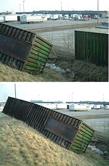 Strong microburst winds flip a several-ton shipping container up the side of a hill, Vaughan, Ontario, Canada
- On 31 March 2019, a very destructive downburst cluster with characteristics of a small derecho
[
clarification needed
]
, but too small to satisfy the criteria, impacted across a 33 km (21 mi) wide and 45 km (28 mi) long swath in the
Bara
and
Parsa Districts
,
Nepal
. Occurring at an elevation of 83 to 109 m (270 to 360 ft)
amsl
around 18:45 local time, the 30-45 min duration winds flattened many and severely damaged numerous buildings, leading to 28 deaths and hundreds of injuries.
[52]
- On 15 May 2018, an extremely powerful front moved through the northeastern United States, specifically
New York
and
Connecticut
, causing significant damage. Nearly a half million people lost power and 5 people were killed. Winds were recorded in excess of 100 mph (160 km/h) and several tornadoes and macrobursts were confirmed by the NWS.
- On 3 April 2018, a wet microburst struck
William P. Hobby Airport
, Texas at 11:53 PM, causing an aircraft hangar to partially collapse. Six business jets (four stored in the hangar and two outside) were damaged. A severe thunderstorm warning was issued just seconds before the microburst struck.
- On 23 May 2017, a wet microburst struck
Sealy, Texas
with 80 to 100 mph (130 to 160 km/h) winds knocking down trees and power lines. Significant damage to structures was reported across Sealy. Twenty students were slightly injured by flying debris while attending a function at Sealy High School.
- On 9 August 2016, a wet microburst struck the city of
Cleveland Heights, Ohio
, an eastern suburb of
Cleveland
.
[53]
[54]
The storm developed very quickly. Thunderstorms developed west of Cleveland at 9 PM, and the
National Weather Service
issued a severe thunderstorm warning at 9:55 PM. The storm had passed over
Cuyahoga County
by 10:20 PM.
[55]
Lightning struck 10 times per minute over Cleveland Heights.
[55]
and 80 mph (130 km/h) winds knocked down hundreds of trees and utility poles.
[54]
[56]
More than 45,000 people lost power, with damage so severe that nearly 6,000 homes remained without power two days later.
[56]
- On 22 July 2016, a wet microburst hit portions of Kent and Providence Counties in Rhode Island, causing wind damage in the cities of
Cranston, Rhode Island
and
West Warwick, Rhode Island
. Numerous fallen trees were reported, as well as downed powerlines and minimal property damage. Thousands of people were without power for several days, even as long as over 4 days. The storm occurred late at night, and no injuries were reported.
- On 23 June 2015, a
macroburst
hit portions of Gloucester and Camden Counties in New Jersey causing widespread damage mostly due to falling trees. Electrical utilities were affected for several days causing protracted traffic signal disruption and closed businesses.
- On 23 August 2014, a dry microburst hit
Mesa, Arizona
. It ripped the roof off of half a building and a shed, nearly damaging the surrounding buildings. No serious injuries were reported.
- On 21 December 2013 a wet microburst hit
Brunswick, Ohio
. The roof was ripped off of a local business; the debris damaged several houses and cars near the business. Due to the time, between 1 am and 2 am, there were no injuries.
- On 9 July 2012, a wet microburst hit an area of
Spotsylvania County, Virginia
near the border of the city of
Fredericksburg
, causing severe damage to two buildings. One of the buildings was a children's cheerleading center. Two serious injuries were reported.
- On 22 June 2012, a wet microburst hit the town of
Bladensburg, Maryland
, causing severe damage to trees, apartment buildings, and local roads. The storm caused an outage in which 40,000 customers lost power.
- On 8 September 2011, at 5:01 PM, a dry microburst hit
Nellis Air Force Base
,
Nevada
causing several aircraft shelters to collapse. Multiple aircraft were damaged and eight people were injured.
[57]
- On 18 August 2011, a wet microburst hit the musical festival
Pukkelpop
in
Hasselt
, causing severe localized damage. Five people were killed and at least 140 people were injured. Later research showed that the wind reached speeds of 170 km/h (110 mph).
- On 22 September 2010, in the
Hegewisch
neighborhood of
Chicago
, a wet microburst hit, causing severe localized damage and localized power outages, including fallen-tree impacts into at least four homes. No fatalities were reported.
[58]
- On 16 September 2010, just after 5:30 PM, a wet
macroburst
with winds of 125 mph (200 km/h) hit parts of Central
Queens
in
New York City
, causing extensive damage to trees, buildings, and vehicles in an area 8 miles long and 5 miles wide. Approximately 3,000 trees were knocked down by some reports. There was one fatality when a tree fell onto a car on the
Grand Central Parkway
.
[59]
[60]
- On 24 June 2010, shortly after 4:30 PM, a wet microburst hit the city of
Charlottesville, Virginia
. Field reports and damage assessments show that Charlottesville experienced numerous downbursts during the storm, with wind estimates at over 75 mph (120 km/h). In a matter of minutes, trees and downed power lines littered the roadways. A number of houses were hit by trees. Immediately after the storm, up to 60,000 Dominion Power customers in Charlottesville and surrounding
Albemarle County
were without power.
[61]
- On 11 June 2010, around 3:00 AM, a wet microburst hit a neighborhood in southwestern
Sioux Falls, South Dakota
. It caused major damage to four homes, all of which were occupied. No injuries were reported. Roofs were blown off of garages and walls were flattened by the estimated 100 mph (160 km/h) winds. The cost of repairs was thought to be $500,000 or more.
[62]
- On 2 May 2009, the lightweight steel and mesh building in
Irving, Texas
used for practice by the
Dallas Cowboys
football team was flattened by a microburst, according to the National Weather Service.
[63]
- On 12 March 2006, a microburst hit
Lawrence, Kansas
. 60 percent of the
University of Kansas
campus buildings sustained some form of damage from the storm. Preliminary estimates put the cost of repairs at between $6 million and $7 million.
[64]
- On 13 May 1989, a microburst with winds over 95 mph (150 km/h) hit Fort Hood, Texas. Over 200 U.S. Army helicopters were damaged. The storm damaged at least 20 percent of the fort's buildings, forcing 25 military families from their quarters. In a preliminary damage estimate, the Army said repairs to almost 200 helicopters would cost $585 million and repairs to buildings and other facilities about $15 million.
[65]
- On May 9, 1980, a microburst at the leading edge of an advancing
cold front
struck the 606 ft (185 m) freighter
MV
Summit Venture
just as it was about to pass through the narrow channel under the
Sunshine Skyway Bridge
over
Tampa Bay
. Sudden torrential rain cut visibility to zero and straight-line winds estimated at over 70 mph (110 km/h) pushed the ship into a support pier, causing the catastrophic collapse of the southbound span and 35 deaths as several private vehicles and a
Greyhound Bus
plummeted 150 ft (46 m) into the water.
[66]
- On 4 July 1977, the
Independence Day Derecho of 1977
formed over west-central
Minnesota
. As the derecho moved east-southeast, it became very intense over central Minnesota around midday. From that time through the afternoon the system produced winds of 80 to more than 100 mph (160 km/h), with areas of extreme damage from central Minnesota into northern
Wisconsin
. The derecho continued rapidly southeast before finally weakening over northern
Ohio
.
See also
[
edit
]
References
[
edit
]
- ^
a
b
US Department of Commerce, NOAA.
"Downbursts"
.
www.weather.gov
. Retrieved
15 June
2022
.
- ^
"Downbursts"
.
PennState
. Retrieved
15 June
2022
.
- ^
Fernando Caracena, Ronald L. Holle, and Charles A. Doswell III.
Microbursts: A Handbook for Visual Identification.
Retrieved on 9 July 2008.
- ^
a
b
Glossary of Meteorology.
Macroburst.
Retrieved on 30 July 2008.
- ^
Peter S. Parke and Norvan J. Larson.
Boundary Waters Windstorm.
Retrieved on 30 July 2008.
- ^
Glossary of Meteorology.
Microburst.
Archived
2008-12-12 at the
Wayback Machine
Retrieved on 2008-07-30.
- ^
Glossary of Meteorology.
Macroburst.
Retrieved on 2008-07-30.
- ^
Glossary of Meteorology.
Straight-line wind.
Archived
2008-04-15 at the
Wayback Machine
Retrieved on 2008-08-01.
- ^
*
Fujita, T.T.
(1985). "The Downburst, microburst and macroburst". SMRP Research Paper 210, 122 pp.
- ^
Glossary of Meteorology.
Straight-line wind.
Archived
15 April 2008 at the
Wayback Machine
Retrieved on 1 August 2008.
- ^
"Facts About Derechos - Very Damaging Windstorms"
.
- ^
"The Corn Belt Derecho of 29 June 1998"
.
- ^
"Facts About Derechos - Very Damaging Windstorms"
.
- ^
"What is a Microburst?"
.
National Weather Service
. n.d
. Retrieved
10 March
2018
.
- ^
University of Illinois
? Urbana Champaign.
Microbursts.
Retrieved on 2008-08-04.
- ^
a
b
Charles A. Doswell III.
Extreme Convective Windstorms: Current Understanding and Research.
Retrieved on 2008-08-04.
- ^
"Oklahoma "heat burst" sends temperatures soaring"
. USA Today|1999-07-08. 8 July 1999. Archived from
the original
on 25 December 1996
. Retrieved
9 May
2007
.
- ^
a
b
c
d
e
NASA Langley Air Force Base.
Making the Skies Safer From Windshear.
Archived
2010-03-29 at the
Wayback Machine
Retrieved on 2006-10-22.
- ^
"St. Christophers Cathedral"
. 6 July 2011. Archived from
the original
on 6 July 2011
. Retrieved
5 August
2022
.
- ^
Ranter, Harro.
"ASN Aircraft accident Canadair C-4 Argonaut G-ALHE Kano International Airport (KAN)"
.
aviation-safety.net
. Retrieved
5 August
2022
.
- ^
"Katasztrofa Koppenhagaban: a gyilkos learamlas"
.
iho.hu
(in Hungarian)
. Retrieved
5 August
2022
.
- ^
Ranter, Harro.
"ASN Aircraft accident Fairchild FH-227B N4215 Saint Louis-Lambert International Airport, MO (STL)"
.
aviation-safety.net
. Retrieved
12 September
2022
.
- ^
Ranter, Harro.
"ASN Aircraft accident Boeing 707-321B N454PA Pago Pago International Airport (PPG)"
.
aviation-safety.net
. Retrieved
12 September
2022
.
- ^
Ranter, Harro.
"ASN Aircraft accident Boeing 727-224 N88777 Denver-Stapleton International Airport, CO (DEN)"
.
aviation-safety.net
. Retrieved
13 September
2022
.
- ^
Ranter, Harro.
"ASN Aircraft accident McDonnell Douglas DC-9-31 N994VJ Philadelphia International Airport, PA (PHL)"
.
aviation-safety.net
. Retrieved
13 September
2022
.
- ^
Ranter, Harro.
"ASN Aircraft accident Boeing 727-224 Advanced N32725 Tucson International Airport, AZ (TUS)"
.
aviation-safety.net
. Retrieved
13 September
2022
.
- ^
Ranter, Harro.
"ASN Aircraft accident Tupolev Tu-154B-2 CCCP-85355 Alma-Ata Airport (ALA)"
.
aviation-safety.net
. Retrieved
12 September
2022
.
- ^
"Runway excursion, USAir Inc., Flight 183, McDonnell Douglas DC9-31, N964VJ, Detroit Metropolitan Airport, Detroit, Michigan, June 13 1983"
(PDF)
.
- ^
"Collision with localizer on takeoff, United Airlines Flight 663, Boeing 727"
(PDF)
.
- ^
"Accident Database: Accident Synopsis 07241992"
.
archive.ph
. 20 July 2012. Archived from
the original
on 20 July 2012
. Retrieved
5 August
2022
.
- ^
Aviation Safety Network.
Damage Report.
Retrieved on 2008-08-01.
- ^
Ranter, Harro.
"ASN Aircraft accident McDonnell Douglas DC-9-31 N954VJ Charlotte-Douglas Airport, NC (CLT)"
.
aviation-safety.net
. Retrieved
10 May
2022
.
- ^
Ranter, Harro.
"ASN Aircraft accident Xian Yunshuji Y-7-100C B-3479 Wuhan"
.
www.aviation-safety.net
. Retrieved
21 July
2022
.
- ^
Ranter, Harro.
"ASN Aircraft accident Airbus A320-214 EC-HKJ Bilbao Airport (BIO)"
.
aviation-safety.net
. Retrieved
12 September
2022
.
- ^
"ATL05CA100"
. 11 October 2006. Archived from
the original
on 11 October 2006
. Retrieved
10 May
2022
.
- ^
"Blimp Crash-Lands In Florida"
.
www.cbsnews.com
. 17 June 2005
. Retrieved
12 September
2022
.
- ^
Ranter, Harro.
"ASN Aircraft accident McDonnell Douglas DC-9-32 5N-BFD Port Harcourt Airport (PHC)"
.
aviation-safety.net
. Retrieved
12 September
2022
.
- ^
Ranter, Harro.
"ASN Aircraft accident Boeing 737-2B7 5N-BFK Abuja International Airport (ABV)"
.
aviation-safety.net
. Retrieved
12 September
2022
.
- ^
Ranter, Harro.
"ASN Aircraft accident Canadair CL-600-2B19 Regional Jet CRJ-100ER 4L-GAE Kinshasa-N'Djili Airport (FIH)"
.
aviation-safety.net
. Retrieved
12 September
2022
.
- ^
Ranter, Harro.
"ASN Aircraft accident Boeing 737-236A AP-BKC Islamabad-Benazir Bhutto International Airport (ISB)"
.
aviation-safety.net
. Retrieved
10 May
2022
.
- ^
Ranter, Harro.
"ASN Aircraft accident Embraer ERJ 190AR XA-GAL Durango-Guadalupe Victoria Airport (DGO)"
.
www.aviation-safety.net
. Retrieved
10 May
2022
.
- ^
Ranter, Harro.
"ASN Aircraft accident Boeing 737-8AS (WL) VQ-BJI Adler/Sochi Airport (AER)"
.
aviation-safety.net
. Retrieved
1 November
2022
.
- ^
"Strongest microburst"
.
Guinness World Records
.
Archived
from the original on 6 January 2022
. Retrieved
6 January
2022
.
- ^
Fonstein, Clare (22 June 2023).
"Record-breaking winds detected during Wednesday night's storm, stronger than Hurricane Ike"
.
Houston Chronicle
.
- ^
"Photos and videos | Strong storms cause damage across Houston area"
. 21 June 2023.
- ^
Dominguez, Catherine (27 June 2023).
"With 230 homes damaged in storm, Montgomery County extends disaster declaration"
.
The Courier of Montgomery County
.
- ^
"Strong winds flip plane upside down at Hooks Airport north of Houston"
. 22 June 2023.
- ^
Carson, Dan (22 June 2023).
"Severe storms flip airplane at Houston-area airfield"
.
Chron
.
- ^
"NTP extends May 21st Ottawa-area EF2 downburst"
.
www.uwo.ca
. Northern Tornadoes Project. 9 June 2022
. Retrieved
16 June
2022
.
- ^
"Ottawa storm winds reached 190 km/h: researchers"
.
Ottawa
. 25 May 2022
. Retrieved
16 June
2022
.
- ^
"Derecho Storm Ranks 6th Largest Insured Loss Event in Canadian History"
.
ca.finance.yahoo.com
. Retrieved
16 June
2022
.
- ^
Kumar Pokharel, Ashok (2021). "A straight-line wind hit some parts of Bara and Parsa districts of Nepal".
Weather
.
doi
:
10.1002/wea.4050
.
S2CID
238649713
.
- ^
Roberts, Samantha (10 August 2016).
"What happened in Cleveland Heights Tuesday night?"
.
KLTV
. Retrieved
15 August
2016
.
- ^
a
b
Steer, Jen; Wright, Matt (10 August 2016).
"Damage in Cleveland Heights caused by microburst"
.
Fox8.com
. Retrieved
15 August
2016
.
- ^
a
b
Reardon, Kelly (10 August 2016).
"Wind gusts reached 58 mph, lightning struck 10 times a minute in Tuesday's storms"
.
The Plain Dealer
. Retrieved
15 August
2016
.
- ^
a
b
Higgs, Robert (11 August 2016).
"About 4,000 customers, mostly in Cleveland Heights, still without power from Tuesday's storms"
.
The Plain Dealer
. Retrieved
15 August
2016
.
- ^
Gorman, Tom (8 September 2011).
"8 injured at Nellis AFB when aircraft shelters collapse in windstorm ? Thursday, Sept. 8, 2011 | 9 p.m."
Las Vegas Sun
. Retrieved
30 November
2011
.
- ^
"Microbursts reported in Hegewisch, Wheeling"
. Chicago Breaking News. 22 September 2010
. Retrieved
30 November
2011
.
- ^
"New York News, Local Video, Traffic, Weather, NY City Schools and Photos ? Homepage ? NY Daily News"
.
Daily News
. New York.
- ^
"Power Restored to Tornado Slammed Residents: Officials"
. NBC New York. 20 September 2010
. Retrieved
30 November
2011
.
- ^
"Charlottesville Continues Storm Cleanup; Hundreds Remain Without Power"
. Archived from
the original
on 3 September 2012
. Retrieved
26 June
2010
.
and
http://www.nbc29.com/Global/story.asp?S=12705577
Archived
6 August 2016 at the
Wayback Machine
- ^
Brian Kushida (11 June 2010).
"Strong Winds Rip Through SF Neighborhood ? News for Sioux Falls, South Dakota, Minnesota and Iowa"
. Keloland.com. Archived from
the original
on 27 September 2011
. Retrieved
30 November
2011
.
- ^
Gasper, Christopher L. (6 May 2009).
"Their view on matter: Patriots checking practice facility"
. The Boston Globe
. Retrieved
12 May
2009
.
- ^
"One year after microburst, recovery progresses"
KU.edu. Retrieved 21 July 2009.
- ^
"Storm Wrecks New Copters"
.
The New York Times
. 20 May 1989
. Retrieved
2 June
2020
.
- ^
Heller, Jean (7 May 2000).
"The Day Skyway Fell: May 9, 1980"
.
St. Petersburg Times
. Archived from
the original
on 23 March 2018
. Retrieved
4 July
2007
.
Bibliography
[
edit
]
- Fujita, T. T.
(1981). "Tornadoes and Downbursts in the Context of Generalized Planetary Scales".
Journal of the Atmospheric Sciences
, 38 (8).
- Wilson, James W. and
Roger M. Wakimoto
(2001). "The Discovery of the Downburst ? TT Fujita's Contribution".
Bulletin of the American Meteorological Society
, 82 (1).
- National Weather Service. "Downbursts". National Weather Service Forecast Office Columbia, SC. 5 May 2010. 4 December 2010.
http://www.erh.noaa.gov/cae/svrwx/downburst.htm
- Fujita, T.T.
(1981). "Tornadoes and Downbursts in the Context of Generalized Planetary Scales".
Journal of the Atmospheric Sciences
, 38 (8).
- Fujita, T.T.
(1985). "The Downburst, microburst and macroburst". SMRP Research Paper 210, 122 pp.
- Wilson, James W. and
Roger M. Wakimoto
(2001). "The Discovery of the Downburst ? TT Fujita's Contribution".
Bulletin of the American Meteorological Society
, 82 (1).
External links
[
edit
]
Wikimedia Commons has media related to
Downburst
.