Former principal local government divisions of Northern Ireland
| Counties of Northern Ireland
|
|---|
 |
| Category
| Former local government
|
|---|
| Location
| Northern Ireland
|
|---|
| Number
| Six
|
|---|
| Populations
| 63,585 (
Fermanagh
)
651,321 (
Antrim
)
|
|---|
| Areas
| 512 sq mi (1,330 km
2
) (
Armagh
)
1,261 sq mi (3,270 km
2
) (
Tyrone
)
|
|---|
| Government
| - Grand jury (to 1898) / County council (1899?1973)
|
|---|
| Subdivisions
| |
|---|
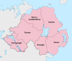
Northern Ireland
is divided into six counties, namely:
Antrim
,
Armagh
,
Down
,
Fermanagh
,
Londonderry
[n 1]
and
Tyrone
. Six largely rural
administrative counties
based on these were among the eight primary local government areas of Northern Ireland from
its 1921 creation
until
1973
.
[1]
The other two local government areas were the urban
county boroughs
of
Derry
[n 1]
(geographically part of the County of Londonderry) and
Belfast
(geographically split between the counties of Antrim and Down).
The six counties date from the
Kingdom of Ireland
; five were created between 1570 and 1591 in the
Tudor conquest of Ireland
, while county Londonderry dates from 1613 and the
Plantation of Ulster
.
[2]
The total number of
counties in the island of Ireland
is 32, with Northern Ireland and the
Republic of Ireland
often respectively called
"the Six Counties"
and "the Twenty-Six Counties", especially by
Irish nationalists
opposed to the
partition of Ireland
. The 1898?1973 administrative counties were subdivided into
county districts
. The two-tier county/district system was replaced with a
single-tier
of "districts",
numbering 26 in 1973
and
rationalised into 11
in 2015. The areas corresponding to the six counties and two county boroughs remain in use for some administrative purposes, and the six historic counties retain a popular identity.
The counties
| County
|
County town
|
Created
[2]
|
Area
[3]
|
Population (2021)
[4]
|
Notes
|
| Antrim
|
Antrim
|
1570
|
308,645 hectares (762,680 acres)
[n 2]
|
651,321
|
Formed after
Shane O'Neill
's rebellion. Lost
North East Liberties of Coleraine
in 1613. The namesake town of
Antrim
was never the administrative centre of the post-1570 county.
|
| Armagh
|
Armagh
|
1571
|
132,698 hectares (327,900 acres)
|
194,394
|
Lost
Slieve Foy
to
County Louth
c.1630.
[2]
|
| Down
|
Downpatrick
|
1570
|
248,905 hectares (615,060 acres)
[n 2]
|
553,261
|
Formed after Shane O'Neill's rebellion.
|
| Fermanagh
|
Enniskillen
|
1588
|
185,097 hectares (457,380 acres)
|
63,585
|
Based on the territory of the Maguires.
|
| Londonderry
|
Coleraine
|
1613
|
211,826 hectares (523,430 acres)
[n 3]
|
252,231
|
Merging of
County Coleraine
(formed 1603) with
Loughinsholin
(from Tyrone),
North East Liberties of Coleraine
(
Antrim
), and
North-West Liberties of Londonderry
(
Donegal
).
|
| Tyrone
|
Omagh
|
1591
|
326,550 hectares (806,900 acres)
|
188,383
|
Based on the Irish kingdom of
Tir Eoghain
. Lost
Loughinsholin
in 1613.
|
Origins
The English administration in Ireland in the years following the
Anglo-Norman invasion of Ireland
created counties as the major subdivisions of an Irish province.
[6]
This process lasted a period from the 13th to 17th centuries; however, the number and shape of the counties that would form the future Northern Ireland would not be defined until the
Flight of the Earls
allowed the shiring of Ulster from 1604.
[1]
Each county would have an associated county town, with county courts of
quarter sessions
and
assizes
.
[6]
The area of the modern counties of Antrim and Down was the
Earldom of Ulster
based on
John de Courcy
's 1170s conquest of Gaelic
Ulaid
.
[7]
Between the late 13th and early 14th centuries it was subdivided into multiple shires based around centres of Norman power such as
Antrim
,
Carrickfergus
, and
Newtownards
.
[7]
The
Bruce invasion
(1315?18) saw the devastation of the Earldom of Ulster and its overlordship over the neighbouring Gaelic districts. With the murder of
the last de Burgh earl
in 1333, the resulting Gaelic recovery expanded
Clandeboy
and eroded the earldom's territory until by the 15th century only the areas of Carrickfergus and coastal enclaves in Down remained.
[7]
It was not until the reign of Queen
Elizabeth I
that Ulster would be shired into more counties. After the 1567 death and 1570
attainder
of
Shane O'Neill
, much of Clandeboy was added to the surviving English enclaves to form the new counties of Antrim and Down, preparing for
an abortive private English plantation
. In 1584,
Lord Deputy of Ireland
Sir
John Perrott
created six counties in
Ulster
, based largely on the boundaries of existing lordships; four of the six are now Northern Ireland: Armagh, Coleraine, Fermanagh, and Tyrone. The noncooperation and later rebellion of
Hugh O'Neill, Earl of Tyrone
made Perrott's scheme largely notional until the
Nine Years' War
ended and the
Flight of the Earls
allowed the
Plantation of Ulster
to reinforce the county government. The
County of the town of Carrickfergus
remained separate from County Antrim until the
Local Government (Ireland) Act 1898
, which also promoted the boroughs of Belfast and Derry to
county boroughs
separate from the adjoining administrative counties.
Development of Northern Ireland's counties
-
Later 15th century ? Boundaries of counties and lordships (
black
border) and minor lordships (
grey
border) in Ulster.
-
Early 16th century ? General boundaries of lordships in Ulster.
-
1584 ? General boundaries of the counties of Ulster created by the
Lord Deputy of Ireland
Sir
John Perrott
.
-
1613 ? Ulster after the creation of County Londonderry, from the merger of County Coleraine, the North West Liberties of Londonderry (
1
), Loughinsholin (
2
), and North East Liberties of Coleraine (
3
).
Baronies
Each county is divided into a number of
baronies
, midway between a county and a parish. Baronies are now obsolete as administrative units, partially derived from the territory of an Irish chieftain. By the time the process of turning local Irish kingdoms into baronies occurred throughout the whole of Ulster by the early 17th century as part of the
Plantation of Ulster
, it was already being used for taxation and administrative purposes.
[6]
Baronies were used for many records from the 17th to 19th centuries such as: the Civil Survey; Petty's Down Survey; the Books of Survey and Distribution; the 19th century valuation books and census returns. The Grand Jury representment system would also be based on the barony.
[6]
Government and modern usage
The counties were also used as the administrative unit of local government introduced in Ireland under the 1898 Local Government Act along with
county boroughs
. In regards to Northern Ireland the cities of
Belfast
and
Londonderry
became county boroughs. The administrative counties and county boroughs were abolished as local government areas in Northern Ireland in 1972 and replaced with twenty-six unitary councils, many of which cross county boundaries.
The six administrative counties and two county boroughs remain in use for some purposes, including
car number plates
. The six counties were also used as
postal counties
by the
Royal Mail
for sorting purposes until their abolition in 1996. Outside government, the counties are used for cultural purposes, for example in the
Gaelic Athletic Association
.
 The lieutenancy areas of the UK, with NI shaded orange
Lieutenancy areas
Like the rest of the United Kingdom, Northern Ireland is divided into
lieutenancy areas
[8]
(see map on right). These are areas that have an appointed
Lord Lieutenant
?the representative of the
British monarch
. Northern Ireland has eight lieutenancy areas:
These boundaries of the above are contiguous with the six administrative counties and two county boroughs established by the
Local Government (Ireland) Act 1898
.
Former counties
Former counties which formed part of the six modern counties of Northern Ireland:
- County Coleraine
formed from the territory of the O'Cahans in 1584 by Queen
Elizabeth I
, formed the basis of modern
County Londonderry
.
- Carrickfergus
was formerly a
county of itself
, it extended further than the modern
borough of Carrickfergus
. It was merged into
County Antrim
in 1899.
- Antrim
,
Blathewyc
,
Cragferus
,
Coulrath
,
del Art
,
Dun
,
Ladcathel
and
Twescard
, the seven counties that formed the
Earldom of Ulster
in 1333.
[9]
[10]
- In 1549, Ulster itself was called a county containing the baronies of
Arde
, Bentry,
Dondalk
,
Dufferens
, Gallagh, Grenecastle,
Kroghfergous
,
Lacayall
, Maulyn,
Twscard
, and
Glyns
.
[10]
See also
- ^
a
b
The county and city/county borough officially named
Londonderry
are often called
Derry
; see
Derry/Londonderry name dispute
.
- ^
a
b
Antrim and Down areas are calculated by combining the administrative county areas
[3]
with the areas of the
wards of Belfast
respectively west and east of the
River Lagan
as follows:
[5]
- 308,645 = 304,526 county Antrim + 4118.93 part of Belfast (all wards except Ormeau, Pottinger, Victoria)
- 248,905 = 246,624 county Down + 2281.23 part of Belfast (Ormeau, Pottinger, Victoria wards)
- 905.29 hectares of Belfast tidal area is excluded from both counties
- ^
211,826 = 210,782 county plus 1,044 county borough.
[3]
References
Citations
- ^
a
b
Connolly 2002 p.129
- ^
a
b
c
Moody, Theodore William
;
Martin, Francis X.
;
Byrne, Francis John
, eds. (25 March 2011) [1984].
"Map 45: Counties 1542?1613 [and Notes]"
(PDF)
.
Maps, Genealogies, Lists: A Companion to Irish History, Part II
. A New History of Ireland. Vol. IX. Clarendon Press. 43, 108?109.
ISBN
9780199593064
. Retrieved
11 July
2017
.
- ^
a
b
c
Northern Ireland General Register Office (1975). "Table 1: Area, Buildings for Habitation and Population, 1971".
Census of Population 1971; Summary Tables
(PDF)
. Belfast: HMSO. p. 1
. Retrieved
28 August
2019
.
- ^
"Census 2021 - Northern Ireland - County - Population"
.
nisra.gov.uk
.
NISRA
. Retrieved
24 October
2023
.
- ^
Northern Ireland General Register Office (1975). "Table 4: Area, Population, Buildings for Habitation and Private Households ? County Borough and Wards".
Census of Population 1971; County Report: Belfast County Borough
(PDF)
. Belfast: HMSO. p. 1
. Retrieved
28 August
2019
.
- ^
a
b
c
d
"Areas, regions, and land divisions"
. Public Records Office of Northern Ireland. Archived from
the original
on 24 August 2015.
- ^
a
b
c
Connolly 2002 pp.589?590
- ^
"Northern Ireland (Lieutenancy) Order 1975"
. 1975.
- ^
Bardon, Jonathan:
A History of Ulster
, page 45. The Black Staff Press, 2005.
ISBN
0-85640-764-X
- ^
a
b
Hughes and Hannan:
Place-Names of Northern Ireland, Volume Two, County Down II, The Ards
, The Queen's University of Belfast, 1992.
ISBN
085389-450-7
Sources
- Connolly, Sean J. (2002).
Oxford Companion to Irish History
. Oxford University Press.
ISBN
978-0-19-923483-7
.
- Falkiner, C. Litton (Caesar Litton) (1904).
"The Counties of Ireland"
.
Illustrations of Irish history and topography, mainly of the seventeenth century
. London: Longmans, Green. pp. 103?142: 127?128
. Retrieved
28 August
2019
.
External links
Links to related articles
|
|---|
|