 Temperature regimes of Venezuela
The
Climate of Venezuela
is characterized for being
tropical
and
megathermal
as a result of its
geographical location
near the
Equator
, but because of the topography and the dominant wind direction, several climatic types occur which can be the same as found in
temperate latitudes
, and even
polar regions
. Latitude exerts little influence on the Venezuelan climate. While the coastal cities of Maracaibo, Barcelona, Porlamar and Maiquetia can get extremely hot, cities in valleys such as Merida, Caracas, Los Teques and San Cristobal have cooler climates, and the highest towns of Mucuchies and Apartaderos have cold (tundra) climates.
The hottest part of Venezuela is the northwest (
Paraguana Peninsula
and
Guajira Peninsula
), where temperatures of more than 38 °C (100 °F) are frequently recorded. The coldest part in the country are located in the highest areas of the
Cordillera de Merida
, where temperatures lower than ?2 °C (28 °F) are recorded. The
Venezuelan Coastal Range
and
Guiana Highlands
have average temperatures from 25 °C (77 °F) to 11 °C (52 °F), while the
Llanos
average temperature is over 23 °C (73 °F).
The highest temperature recorded was 42 °C (108 °F) in
Machiques
,
[1]
and the lowest temperature recorded was ?11 °C (12 °F), it has been reported from an uninhabited high altitude at
Paramo de Piedras Blancas
(
Merida state
),
[2]
even though no official reports exist, lower temperatures in the mountains of the
Sierra Nevada de Merida
are known.
Climate zones according to Koppen
[
edit
]
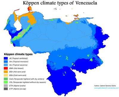 Koppen climate classification map of Venezuela.
According to the
Koppen climate classification
, Venezuela's climate types are:
[3]
Group A: Tropical climates
[
edit
]
It's the most prevalent and characteristic climate of the country. Maintaining temperatures above 18 °C (64 °F) and rainfall in most of the year:
It can be found throughout the country, dominating the
Llanos
and northern
Guayana Region
, as well as other parts of the country. It is dry between December and March with annual rainfall between 600 and 1,500 mm.
It is located in the
Guayana Region
,
Orinoco Delta
, west of
Zulia
, Andean and Coastal range foothills,
Paria Peninsula
and Barlovento region; with rainfall between 1,600 and 2,500 mm per year and a drought of just 45 days.
It's located south of Venezuela,
Orinoco Delta
,
El Tama
area in west of Venezuela, and south of
Maracaibo Lake
. Rainfall exceeds 2,500 mm, not tending dry season.
Group B: Dry climates
[
edit
]
This type of climate the evaporation exceeds precipitation. In Venezuela is typical of desert and arid coastal areas and with annual temperatures above 18 °C. The cold semiarid type can be found at elevated portions of the Andes.
It can be found in
Guajira Peninsula
,
Paraguana Peninsula
,
Araya Peninsula
and most of the
Insular region
.
It is located in the northern part of
Zulia
state, most of the area of
Lara state
and
Falcon state
, the coastal area,
Insular region
and some semi-arid areas in
Venezuelan Andes
.
It can be found locked at the temperate zones of high Andean valleys of
Cordillera de Merida
.
Group C: Temperate climates
[
edit
]
The monthly averages temperatures are below 22 °C (72 °F) but above 0 °C (32 °F). At least one month's average temperature is below 18 °C (64 °F):
It tends to experience noticeably drier weather during the lower-sun "winter" season. It's located in the medium areas of the southern-east slope of
Cordillera de Merida
and
Sierra de Perija
, the highest areas of south-western
Venezuelan coastal range
.
This climate doesn't tend to has a dry season. It's located in the medium areas of the
Cordillera de Merida
and
Sierra de Perija
, the highest areas of
Venezuelan coastal range
, and the top of the highest
Guiana Highlands
Tepuis
.
Group E: Alpine climates
[
edit
]
It's characterized by average temperatures below 10 °C in all 12 months of the year:
Also known as
paramo climate
, this climate often undergo a sudden and drastic change in daily-weather in which they fluctuate between temperatures from below freezing to as high as 20 °C. Mean annual temperatures range from 2 °C (36 °F) to 10 °C (50 °F). It is located above the 3,000 m in the
Sierra de Perija
and
Cordillera de Merida
. The most popular village with this climate in the country is the town of
Apartaderos
[4]
This climate is reserved to the highest peaks of the
Venezuelan Andes
, such as
Pico Bolivar
,
Pico Humboldt
, [
Climate zones according to altitude
[
edit
]
 Venezuelan climatic types, according to their thermal floors.
Venezuelan climates are structured in "thermal floors", as mentioned next:
[5]
[6]
Very Hot
[
edit
]
This climate is characterized by very hot temperatures above 26 °C (79 °F), with precipitations that ranges from dry (less than 300 mm) to pluvial (more than 3300 mm) conditions. This climate can be found in areas below 300 m in sedimentary basins and lowlands such as the
Llanos
,
Orinoco Delta
,
Maracaibo Basin
,
Orinoco Basin
, and coastal plains and islands; it comprises almost all the country. This climate zone is present in cities like
Maracaibo
,
Punto Fijo
,
Ciudad Guayana
,
Porlamar
,
Puerto La Cruz
,
Barinas
,
Tucupita
,
Cumana
,
Maturin
,
Anaco
,
Ciudad Bolivar
,
Cabimas
,
El Vigia
and others.
Warm
[
edit
]
Warm climate can be found between 300 and 650 m. It's characterized by temperatures from 23 °C (73 °F) to 26 °C (79 °F) and precipitations that ranges from scarcely rainy (300 ? 700 mm) to pluvial (more than 3300 mm) conditions. This climate can be found in lower foothills and plateaus in the
Guiana Highlands
,
Venezuelan Coastal Range
,
Coro region
and
Venezuelan Andes
. Cities which have this climate zone are
Barquisimeto
,
Maracay
,
Valencia
,
Guarenas-Guatire
,
San Juan de Los Morros
,
Charallave
,
Valera
,
Barinitas
,
San Antonio del Tachira
,
Quibor
and others.
Cool
[
edit
]
This climate features temperatures between 18 °C (64 °F) to 23 °C (73 °F) and precipitations that ranges from scarcely rainy (300 ? 700 mm) to pluvial (more than 3300 mm) conditions. It can be found in the country's mountainous areas between 650 and 1,350-1,600 m This climate zone is present in cities like
Merida
,
San Cristobal
,
Caracas
,
Sanare
,
Villa de Cura
,
Ejido
,
Trujillo
,
Escuque
,
Rubio
,
Tovar
,
Bocono
,
Duaca
,
Bejuma
,
Los Teques
,
Nirgua
,
Santa Elena de Uairen
, among others.
Mild/Temperate
[
edit
]
Mild or Temperate climate can be found in the mountainous areas between 1,350-1,600 to 2,400 m. It features temperatures around 13 °C (55 °F) to 18 °C (64 °F) and precipitations that ranges from scarcely rainy (300 ? 700 mm) to pluvial (more than 3300 mm) conditions. This climate zone is present in cities like
Merida
(higher part),
Colonia Tovar
,
San Antonio de Los Altos
,
El Jarillo
,
El Junquito
,
Galipan
,
Timotes
,
La Grita
,
Tabay
,
La Mucuy
and others; most of the top of the
tepuis
also present this climate.
Cold
[
edit
]
This climate is characterized by temperatures above 8 °C (46 °F) and below 13 °C (55 °F), with precipitations that ranges from scarcely rainy (300 ? 700 mm) to pluvial (more than 3300 mm) conditions. This climate can be found in mountainous areas around 2,400 to 3,200 m specifically in
Sierra de Perija
,
Cordillera de Merida
, higher elevations at
Venezuelan Coastal Range
and higher
tepuis
(
Monte Roraima
,
Kukenan
,
Cerro Marahuaca
,
Chimanta Massif
). This climate zone is present in towns like
Mucuchies
,
Chachopo
and
Los Nevados
.
Very Cold
[
edit
]
This climate can be found in the
Venezuelan Andes
area, between 3,200 and 4,150 m. It's characterized by temperatures from 3 °C (37 °F) to 8 °C (46 °F) and precipitations that ranges from scarcely rainy (300 ? 700 mm) to rainy (1800?2500 mm) conditions. This climate zone is present in towns like
Apartaderos
and
Llano del Hato
. The condition of this climate is also known as
paramo
Frosty
[
edit
]
Frosty climate is found at the highest areas in
Venezuelan Andes
, between 4,150 and 4,700 m. where the temperatures are between 0 °C (32 °F) to 3 °C (37 °F). This climate zone is present exclusively at
Sierra Nevada de Merida
,
Sierra de La Culata
and
Sierra de Santo Domingo
.
Glacial
[
edit
]
This climate is characterized by average temperatures below 0 °C (32 °F) all year, it's located in the highest peaks of Venezuela in the
Cordillera de Merida
such as
Pico Bolivar
,
Pico Humboldt
,
Pico La Concha
,
Pico Bonpland
,
Pico Espejo
,
Pico Mucunuque
and
Pico Piedras Blancas
. Only Pico Bolivar and Pico Humboldt have their glaciers preserved, while the other peaks are exposed to
nival zone
conditions.
See also
[
edit
]
References
[
edit
]
External links
[
edit
]