Gated community in Jalisco, Mexico
20°36′07″N
103°26′49″W
/
20.60194°N 103.44694°W
/
20.60194; -103.44694
Gated Community in Jalisco, Mexico
Ciudad Bugambilias
|
|---|
|
| Fraccionamiento Ciudad Bugambilias
|
 Seal
|
 |
 |
|
| Coordinates:
20°36′07″N
103°26′49″W
/
20.60194°N 103.44694°W
/
20.60194; -103.44694
|
| Country
| Mexico
|
|---|
| State
| Jalisco
|
|---|
| City
| Zapopan
|
|---|
|
| ? Body
| Asociacion de Colonos de Ciudad Bugambilias A.C.
|
|---|
| Highest elevation
(Second Section, Panoramic)
| 1,850 m (6,070 ft)
|
|---|
| Lowest elevation
(First Section, Jardines)
| 1,647 m (5,404 ft)
|
|---|
| Postcodes
| 45237, 45238
|
|---|
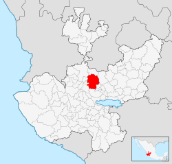
Ciudad Bugambilias (Guadalajara, Mexico)
(
Spanish pronunciation:
[sju?ðað βu?am?biljas]
) is an exclusive
[1]
residential gated neighborhood, located in the municipality of
Zapopan
, part of the metropolitan zone of
Guadalajara
in the state of
Jalisco
,
Mexico
.
[2]
Established in 1975.
[1]
It was one of the first neighborhoods developed towards the south of the city focusing on green communal areas, enclosed by the polygon forestal protected area Cerro del Tajo and part of the
Primavera Forest
.
[3]
It is known to be home to many high-net-worth individuals and affluent established families of the country.
[4]
Its main entrance is located via Avenida Lopez Mateos.
The area is currently monitored by a new system of surveillance C5 introduced in partnership with the state and private police.
Geography
[
edit
]
Divided into two sections, the first located at the bottom of the forest plateau and the second on the hill directly next to the forest and overseeing the city. The second panoramic section has the best
air quality
compared to the rest of the city due to its proximity to the forest.
Green areas are currently protected restricting construction due to their ecological importance and biodiversity since 2018 by the
INAH
(National Institute of Archaeology and History),
SEMARNAT
(Secretariat of Environment and Natural Resources),
SCT
(Secretariat de Communications and Transport), and government of the state of Jalisco.
[3]
Education
[
edit
]
Private schools include
[
edit
]
- Cumbres International School Guadalajara (
Legionaries of Christ
)
- Instituto Alpes Bugambilias (Legionaries of Christ)
- Instituto DaVinci Talentos (Preschool)
Economy
[
edit
]
Shopping malls
[
edit
]
- Plaza Bugambilias
- Plaza Panoramica Bugambilias
Private Clubs
[
edit
]
See also
[
edit
]
References
[
edit
]
