Marine protected area in California
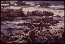
 Feather Duster Worm - Lingcod Reef, Carmel Bay
 Carmel Beach
Carmel Bay State Marine Conservation Area
(SMCA) is a
marine protected area
in
Carmel Bay
. Carmel Bay is adjacent to the city of
Carmel-by-the-Sea
and is near
Monterey
, on
California
’s central coast. The marine protected area covers 2.12 square miles.
[1]
Recreational fishing of
finfish
and limited commercial taking of
kelp
is permitted within the SMCA.
[2]
History
[
edit
]
The Carmel Bay SMCA was established in September 2007 by the California Fish and Game Commission. It was one of 29 marine protected areas adopted during the first phase of the
Marine Life Protection Act Initiative
. The Marine Life Protection Act Initiative (or MLPAI) is a collaborative public process to create a statewide network of marine protected areas along the California coastline.
The Carmel Bay SMCA encourages recreational fishing opportunities in an area close to a nearby port by precluding commercial extraction or take of invertebrates throughout the Bay but allowing sport fishing for finfish from shore, kayak, or boat.
Geography and natural features
[
edit
]
Carmel Bay (SMCA) is near
Carmel Pinnacles State Marine Reserve
,
Point Lobos State Marine Reserve
and
Point Lobos State Marine Conservation Area
. On opposite sides of Carmel Bay are the only two extant stands of
Monterey Cypress
,
Cupressus macrocarpa
.
[3]
This marine protected area is bounded by the mean high tide line and straight lines connecting the following points in the order listed:
[4]
- 36° 33.65’ N. lat. 121° 57.10’ W. long.;
- 36° 31.70’ N. lat. 121° 56.30’ W. long.; and
- 36° 31.70’ N. lat. 121° 55.55’ W. long.
Habitat and wildlife
[
edit
]
Habitats protected by Carmel Bay SMCA include
kelp forest
, sandy beach, submarine canyon head, and surfgrass.
[5]
Recreation and nearby attractions
[
edit
]
Carmel Bay is a tourism and ocean recreation destination. Divers and kayakers are attracted to its unique pinnacle formations, granite reefs and kelp forests. Carmel-By-The-Sea also features an iconic white sand beach.
In nearby Monterey, the
Monterey Bay Aquarium
is a major tourist attraction featuring a 28-foot (8.5 m) living kelp forest. The exhibit includes many of the species native to the nearby marine protected areas. The aquarium also houses
sea otters
, intertidal wildlife, and occasionally
sea turtles
.
California’s marine protected areas encourage recreational and educational uses of the ocean.
[6]
Activities such as kayaking, diving, snorkeling, and swimming are allowed unless otherwise restricted.
Scientific monitoring
[
edit
]
As specified by the Marine Life Protection Act, select marine protected areas along California’s central coast are being monitored by scientists to track their effectiveness and learn more about ocean health. Similar studies in marine protected areas located off of the
Santa Barbara Channel Islands
have already detected gradual improvements in fish size and number.
[7]
References
[
edit
]
- ^
California Department of Fish and Game. “
California Marine Life Protection Act Initiative Summary of Central Coast MPAs as Adopted by the California Fish and Game Commission
Archived
2016-12-21 at the
Wayback Machine
”. Retrieved on December 22, 2008.
- ^
California Department of Fish and Game. "
Online Guide to California’s Central Coast Marine Protected Areas
Archived
2010-01-13 at the
Wayback Machine
". Retrieved on December 18, 2008.
- ^
C. Michael Hogan and Michael P. Frankis. 2009.
Monterey Cypress: Cupressus macrocarpa
, GlobalTwitcher.com ed. N. Stromberg
Archived
2017-09-06 at the
Wayback Machine
- ^
California Department of Fish and Game. "
Central Coast Marine Protected Areas
Archived
2010-05-20 at the
Wayback Machine
". Retrieved December 18, 2008.
- ^
Department of Fish and Game. "
Appendix O. Regional MPA Management Plans"
Archived
2018-06-10 at the
Wayback Machine
. Master Plan for Marine Protected Areas (approved February 2008). Retrieved December 18, 2008.
- ^
Department of Fish and Game. "
California Fish and Game Code section 2853 (b)(3)
Archived
2013-03-26 at the
Wayback Machine
". Marine Life Protection Act. Retrieved December 18, 2008.
- ^
Castell, Jenn, et al. "
How do patterns of abundance and size structure differ between fished and unfished waters in the Channel Islands? Results from SCUBA surveys
Archived
May 31, 2010, at the
Wayback Machine
". Partnership for Interdisciplinary Studies of Coastal Oceans (PISCO) at University of California, Santa Barbara and University of California, Santa Cruz; Channel Islands National Park. Retrieved December 18, 2008.
External links
[
edit
]
|
|---|
|
|---|
| Parks
| |
|---|
| Preserves
| |
|---|
| Monuments
| |
|---|
| Seashores
| |
|---|
| Historical Parks
| |
|---|
| Historic Sites
| |
|---|
| Memorials
| |
|---|
| Recreation Areas
| |
|---|
|
|
|
|---|
| Parks
| |
|---|
| Natural Reserves
| |
|---|
| Marine Reserves
| |
|---|
| Historic Parks
| |
|---|
| Beaches
| |
|---|
| Recreation Areas
| |
|---|
Vehicular
Recreation Areas
| |
|---|
| Other
| |
|---|
|
|
|
|---|
National Forests
and Grasslands
| |
|---|
National Wilderness
Preservation System
| |
|---|
National Monuments
and Recreation Areas
| |
|---|
|
|
|
|
|
|---|
Wildlife
Areas
| |
|---|
Ecological
Reserves
| |
|---|
Marine
Protected
Areas
| |
|---|
|
|
|
|---|
| National Monuments
| |
|---|
National
Conservation Areas
| |
|---|
| Wilderness Areas
| |
|---|
|
|
|
|
|
|
|
|
|---|
| Historic sites
| | Historic buildings
| |
|---|
Historic
mission churches
| |
|---|
| Literary sites
| |
|---|
|
|---|
| Museums
| |
|---|
| Arboretums and gardens
| |
|---|
| Golf courses
| |
|---|
| Cultural
| Performing arts
centers and venues
| |
|---|
Annual events
and festivals
| |
|---|
| Sports venues
| |
|---|
|
|---|
| Outdoors
| | Regions
| |
|---|
| Trails
| |
|---|
Regional parks
and lakes
| |
|---|
Reserves, preserves,
and refuges
| |
|---|
| State parks
| |
|---|
| National parks
| |
|---|
| National forests
| |
|---|
| Scenic drives
| |
|---|
|
|---|
36°32′53″N
121°56′19″W
/
36.5480°N 121.9387°W
/
36.5480; -121.9387