City in Wisconsin, United States
Black River Falls
is a city in and the county seat of
Jackson County
,
Wisconsin
, United States. The population was 3,523 at the
2020 census
.
[4]
It is home to the administrative center of the
Ho-Chunk
Nation.
[7]
History
[
edit
]
 Falls of the
Black River
Falls of the
Black River
Black River Falls was founded to utilize the
waterpower
of the
Black River
. As the area was predominantly forest at the time, its primary use was in operating
sawmills
.
A large monument to Black River Falls' veterans of
World War I
,
World War II
, the
Korean War
, and the
Vietnam War
, as well as to local
Medal of Honor
recipient
Mitchell Red Cloud, Jr.
, was erected near the Chamber of Commerce Building at 101 S. 2nd Street. Named the "Field of Honor", the attached plaques provide accounts of the veterans' services. This site is also the start of the four-mile (6.5 km) Foundation Trail, a signed hiking and bike path that circles the eastern part of the community.
Black River Falls is the focus of
Michael Lesy
's book
Wisconsin Death Trip
(1973), which used photographs and newspaper cuttings to highlight the harshness of life in the community during the late nineteenth century and the effects it had on the psychology of the inhabitants.
Geography
[
edit
]
Black River Falls is located at
44°17′50″N
90°50′57″W
/
44.29722°N 90.84917°W
/
44.29722; -90.84917
(44.297166, -90.849263).
[8]
According to the
United States Census Bureau
, the city has a total area of 4.20 square miles (10.88 km
2
), of which, 4.10 square miles (10.62 km
2
) is land and 0.10 square miles (0.26 km
2
) is water.
[9]
The city is located on the falls of the
Black River
at the northeast edge of the
Driftless Area
, where the river cuts through a region of granite.
[10]
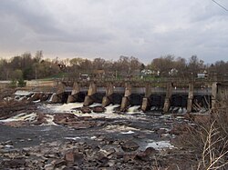
The falls are covered by a
hydroelectric dam
, forming the 200-acre (0.81 km
2
) Black River Flowage.
[11]
Black River Falls dam and hydro plant
Owned by the City
Demographics
[
edit
]
Historical population
| Census
| Pop.
| Note
| %±
|
|---|
| 1860
| 570
| | ?
|
|---|
| 1870
| 1,101
| | 93.2%
|
|---|
| 1880
| 1,427
| | 29.6%
|
|---|
| 1890
| 2,261
| | 58.4%
|
|---|
| 1900
| 1,938
| | ?14.3%
|
|---|
| 1910
| 1,917
| | ?1.1%
|
|---|
| 1920
| 1,796
| | ?6.3%
|
|---|
| 1930
| 1,950
| | 8.6%
|
|---|
| 1940
| 2,539
| | 30.2%
|
|---|
| 1950
| 2,824
| | 11.2%
|
|---|
| 1960
| 3,195
| | 13.1%
|
|---|
| 1970
| 3,273
| | 2.4%
|
|---|
| 1980
| 3,434
| | 4.9%
|
|---|
| 1990
| 3,490
| | 1.6%
|
|---|
| 2000
| 3,618
| | 3.7%
|
|---|
| 2010
| 3,622
| | 0.1%
|
|---|
| 2019 (est.)
| 3,465
| [6]
| ?4.3%
|
|---|
|
2020 census
[
edit
]
As of the
census of 2020
,
[4]
the population was 3,523. The
population density
was 841.8 inhabitants per square mile (325.0/km
2
). There were 1,748 housing units at an average density of 417.7 units per square mile (161.3 units/km
2
). The racial makeup of the city was 86.3%
White
, 6.0%
Native American
, 1.1%
Black
or
African American
, 0.3%
Asian
, 0.9% from
other races
, and 5.4% from two or more races. Ethnically, the population was 3.1%
Hispanic
or
Latino
of any race.
According to the
American Community Survey
estimates for 2016?2020, the median income for a household in the city was $39,155, and the median income for a family was $71,250. Male full-time workers had a median income of $38,682 versus $37,974 for female workers. The
per capita income
for the city was $28,050. About 9.6% of families and 15.0% of the population were below the
poverty line
, including 7.6% of those under age 18 and 13.4% of those age 65 or over.
[13]
Of the population age 25 and over, 96.1% were high school graduates or higher and 20.7% had a bachelor's degree or higher.
[14]
2010 census
[
edit
]
As of the
census
[15]
of 2010, there were 3,622 people, 1,613 households, and 845 families residing in the city. The
population density
was 883.4 inhabitants per square mile (341.1/km
2
). There were 1,732 housing units at an average density of 422.4 units per square mile (163.1 units/km
2
). The racial makeup of the city was 91.5%
White
, 0.5%
African American
, 5.2%
Native American
, 0.3%
Asian
, 0.2% from
other races
, and 2.3% from two or more races.
Hispanic
or
Latino
of any race were 1.7% of the population.
There were 1,613 households, of which 26.2% had children under the age of 18 living with them, 36.7% were
married couples
living together, 11.7% had a female householder with no husband present, 4.0% had a male householder with no wife present, and 47.6% were non-families. 41.5% of all households were made up of individuals, and 17.4% had someone living alone who was 65 years of age or older. The average household size was 2.13 and the average family size was 2.89.
The median age in the city was 41.6 years. 22.8% of residents were under the age of 18; 6.8% were between the ages of 18 and 24; 24.4% were from 25 to 44; 24.7% were from 45 to 64; and 21.2% were 65 years of age or older. The gender makeup of the city was 48.4% male and 51.6% female.
2000 census
[
edit
]
As of the
census
[5]
of 2000, there were 3,618 people, 1,563 households, and 886 families residing in the city. The
population density
was 1,146.4 people per square mile (442.6 people/km
2
). There were 1,679 housing units at an average density of 532.0 units per square mile (205.4 units/km
2
). The racial makeup of the city was 93.37%
White
, 0.19%
African American
, 4.73%
Native American
, 0.11%
Asian
, 0.08%
Pacific Islander
, 0.55% from
other races
, and 0.97% from two or more races.
Hispanic
or
Latino
of any race were 1.16% of the population.
There were 1,563 households, out of which 25.8% had children under the age of 18 living with them, 43.4% were
married couples
living together, 10.2% had a female householder with no husband present, and 43.3% were non-families. 38.0% of all households were made up of individuals, and 19.6% had someone living alone who was 65 years of age or older. The average household size was 2.15 and the average family size was 2.82.
In the city, the population was spread out, with 20.8% under the age of 18, 8.9% from 18 to 24, 24.2% from 25 to 44, 21.3% from 45 to 64, and 24.8% who were 65 years of age or older. The median age was 42 years. For every 100 females, there were 87.1 males. For every 100 females age 18 and over, there were 81.3 males.
Government
[
edit
]
 Courthouse
City Hall, located at 101 S. 2nd St, houses the mayor, Jay Eddy; the city administrator, Brad Chown; deputy city clerks and treasurers; the Parks and Recreation Department and the Police Department. Offices for Jackson County are located on Main Street.
[16]
Economy
[
edit
]
 Black River Falls
industrial park
water tower
Black River Falls
industrial park
water tower
See also:
Water tower cellular
While the logging and lumber industry is still present in the area, the current economy leans heavily on
agriculture
and
tourism
. Several locations support the tourism industry. Lake Arbutus, a 839-acre (3.40 km
2
) impoundment of the river, lies several miles northeast, as does the multi-use
Levis/Trow trail system
. Black River Falls is home to a
casino
and hotel operated by the
Ho-Chunk
Nation. Much of the surrounding land is part of the Black River State Forest.
[17]
Education
[
edit
]
 Former high school
Black River Falls High School
, the city's public high school located on the southwestern edge of town, is administered by the Black River Falls School District. The
former high school
, in the center of the city, has been converted to apartments.
Western Technical College
offers classes in the city.
Media
[
edit
]
Black River Falls has one newspaper, The Banner Journal. The local radio stations are
WWIS
99.7 FM and 1260 AM; and
WXYM
96.1 FM.
Culture
[
edit
]
Black River Falls is the focus of
Michael Lesy
's book
Wisconsin Death Trip
(1973), which used photographs and newspaper cuttings to highlight the harshness of life in the community during the late nineteenth century and the effects it had on the psychology of the inhabitants. The book was made into a
film
in 1999, which included scenes from the community as it appeared then.
Lesy drew on the work of Charles Van Schaick, a photographer in Black River Falls between the 1870s and 1930s. Van Schaick made portraits of the
Ho-Chunk
(Winnebago) people in the area in his commercial studio in downtown Black River Falls. His photographs are now housed at the
Wisconsin Historical Society
and were the subject of a book,
People of the Big Voice
, published in 2011.
[18]
The Black River Falls area is home to a large population of the
endangered
Karner Blue
butterfly
.
[19]
The city celebrates with the Karner Blue Butterfly Festival held annually on the third Saturday of July.
Transportation
[
edit
]
 Looking west at downtown Black River Falls on
WIS 54
Looking west at downtown Black River Falls on
WIS 54
Major highways
[
edit
]
The primary artery of transportation for Black River Falls is
Interstate 94
, which passes through the eastern edge of the city.
US Highway 12
,
Wisconsin Highway 27
, and
Wisconsin Highway 54
also pass through the city.
Airport
[
edit
]
Black River Falls Area Airport
(KBCK) serves the city and surrounding communities.
Rail
[
edit
]
The
Union Pacific Railroad
is adjacent to the city, but does not pass through the center.
[20]
Its predecessor, the
Chicago and North Western Railway
, formerly operated a
branch line
into the town to serve an
iron ore
mine.
Transit
[
edit
]
Black River Falls Public Transit operates a
dial-a-ride
transit service in the city.
Notable people
[
edit
]
Images
[
edit
]
References
[
edit
]
- ^
Unit 4: Personal Information
(PDF)
. Hooc?k Waaziija Haci Language Division. p. 96
. Retrieved
July 13,
2022
.
- ^
"2019 U.S. Gazetteer Files"
. United States Census Bureau
. Retrieved
August 7,
2020
.
- ^
a
b
"US Board on Geographic Names"
.
United States Geological Survey
. October 25, 2007
. Retrieved
January 31,
2008
.
- ^
a
b
c
"2020 Decennial Census: Black River Falls city, Wisconsin"
.
data.census.gov
. U.S. Census Bureau
. Retrieved
July 1,
2022
.
- ^
a
b
"U.S. Census website"
.
United States Census Bureau
. Retrieved
January 31,
2008
.
- ^
a
b
"Population and Housing Unit Estimates"
. United States Census Bureau. May 24, 2020
. Retrieved
May 27,
2020
.
- ^
"Ho-chunk Nation"
.
www.ho-chunknation.com
. Archived from
the original
on April 14, 2018
. Retrieved
April 23,
2018
.
- ^
"US Gazetteer files: 2010, 2000, and 1990"
.
United States Census Bureau
. February 12, 2011
. Retrieved
April 23,
2011
.
- ^
"US Gazetteer files 2010"
.
United States Census Bureau
. Archived from
the original
on January 25, 2012
. Retrieved
November 18,
2012
.
- ^
"Jackson County"
. Archived from
the original
on August 13, 2009
. Retrieved
July 4,
2009
.
Jackson County Website
- ^
Black River - WDNR
Archived
October 10, 2007, at the
Wayback Machine
- ^
"Census of Population and Housing"
. Census.gov
. Retrieved
June 4,
2015
.
- ^
"Selected Economic Characteristics, 2020 American Community Survey: Black River Falls city, Wisconsin"
.
data.census.gov
. U.S. Census Bureau
. Retrieved
December 21,
2022
.
- ^
"Selected Social Characteristics, 2020 American Community Survey: Black River Falls city, Wisconsin"
.
data.census.gov
. U.S. Census Bureau
. Retrieved
December 21,
2022
.
- ^
"U.S. Census website"
.
United States Census Bureau
. Retrieved
November 18,
2012
.
- ^
"County Clerk"
. Archived from
the original
on August 13, 2009
. Retrieved
July 4,
2009
.
Jackson County Offices
- ^
"Black River State Forest"
.
Wisconsin Department of Natural Resources
. Retrieved
January 31,
2017
.
- ^
"Charles Van Schaick: A Voice From the Passion of Nature"
.
wordpress.com
. July 25, 2013
. Retrieved
April 23,
2018
.
- ^
"Archived copy"
(PDF)
. Archived from
the original
(PDF)
on February 10, 2017
. Retrieved
February 9,
2017
.
{{
cite web
}}
: CS1 maint: archived copy as title (
link
)
- ^
[1]
Wisconsin DOT Railway Map
- ^
'Wisconsin Blue Book 1942,' Biographical Sketch of Oswald H. Johnson, pg. 47
- ^
'Wisconsin Blue Book 1877,' Biographical Sketch of Carl C. Pope, pg. 463
External links
[
edit
]
|
|---|
| International
| |
|---|
| National
| |
|---|
| Geographic
| |
|---|