Mountain range in Germany
 Bergisches Land,
North Rhine-Westphalia
, Germany
Bergisches Land,
North Rhine-Westphalia
, Germany
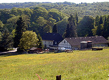 View of the woods of Burg with a typical Bergisches farmhouse
 Iuliacensis et Montensis Ducatus, 1645, by
Blaeu
Iuliacensis et Montensis Ducatus, 1645, by
Blaeu
The
Bergisches Land
(
German:
[?b??????s
?lant]
,
Berg
Country
) is a low
mountain range
in the state of
North Rhine-Westphalia
,
Germany
, east of the
Rhine
and south of the
Ruhr
. The landscape is shaped by forests, meadows, rivers and creeks and contains over twenty artificial lakes.
[1]
Wuppertal
is the biggest town, while the southern part has economic and socio-cultural ties to
Cologne
. Wuppertal and the neighbouring cities of
Remscheid
and
Solingen
form the Bergisches Stadtedreieck (
Berg City Triangle
).
Geography
[
edit
]
Demarcation
[
edit
]
Historically
[
edit
]
The Bergisches Land emerged from the historic
Duchy of Berg
. The region also owes its name to the former sovereigns, the Counts (and later Dukes) of the
House of Berg
[
bg
;
de
;
ru
;
uk
]
. The adjectival Latin term terre Montensis, i.e. of the Bergisches Land, was first recorded in writing in a
Bergisch office constitution in 1363
[
de
]
, although terra de Monte or Land von Berg appeared in earlier documents.
[2]
Important places in the duchy were
Gerresheim
,
Elberfeld
,
Solingen
,
Lennep
,
Radevormwald
,
Wipperfurth
,
Bensberg
,
Siegburg
and
Blankenberg
[
de
;
nl
]
, most of which received city rights from the 13th century. The seat of the counts and dukes was initially
Berge Castle
[
de
]
in
Altenberg
near
Odenthal
, after the construction of
Burg Castle
the town of
Burg an der Wupper
[
de
]
(today a district of Solingen) and then from 1386 to 1822
Dusseldorf
, which the dukes became a representative residence - and expanded the capital of the Duchy. The
Bergisch lion
[
de
]
in Dusseldorf's coat of arms still points to the historical affiliation of Dusseldorf to the Bergisches Land.
The northern parts of the Bergisches Land included the cities of
Mulheim an der Ruhr
, parts of
Duisburg
,
Essen
and
Oberhausen
(
Alstaden
[
de
;
nl
]
and
Dumpten
[
de
;
pl
]
), and the areas on the western border also included the area on the right bank of the Rhine, Cologne near
Mulheim
. Smaller areas on the left bank of the Rhine belonging to the duchy were also
Wesseling
,
Rodenkirchen
,
Orr
[
de
;
ksh
;
nl
]
and
Langel
[
de
]
[3]
The former lordships of
Gimborn
[
de
]
and
Homburg
[
de
]
in today's
Oberberg district
, on the other hand, were only added to the Grand
Duchy of Berg
during
Napoleon
's time. This originally non-Bergisch area includes
Marienheide
,
Wiehl
,
Numbrecht
, the town of
Bergneustadt
and today's district seat of the Oberbergischer district:
Gummersbach
.
Geographically
[
edit
]
The
natural region
Bergisches Land lies almost entirely in the main unit group
Suder Uplands
, which also includes almost the entire
Sauerland
. The Suder Uplands represent the north-eastern part of the
Rhenish Massif
on the right bank of the Rhine.
Natural
orographic
borders form the
Ruhr
in the north, the
Rhine
in the west and the
Sieg
in the south. To the east it merges into the Sauerland without a recognizable scenic border. Political and cultural differences alone determine the course of the border between the two historical landscapes, which, however, roughly corresponds to the eastern
watersheds
of
Wupper
and
Agger
, while the (western) Sauerland is mainly drained by the Ruhr and its tributaries.
The largest part of the Bergisches Land is characterized by a varied low mountain range landscape with forests, meadows and hills as well as narrow
notch valley
[
de
;
fr
;
ja
;
nl
;
pt
]
s also called
Siepen
with small streams. Except for the areas that transition into the Sauerland, the Bergisches Land is referred to as
peneplain
due to the advanced erosion of the mountains.
Westwards from the low mountain range, across various
Bergische Heideterrasses
[
de
]
, a plain without significant elevations, which is highly sprawled by the
urban agglomerations
of
Cologne
and
Dusseldorf
and - compared to the low mountain range landscape - is very little structured. Here, with a few
heath
relics, such as the
Wahn Heath
[
de
]
,
Hilden Heath
[
de
;
ru
]
and
Ohligs Heath
[
de
]
, the spacious forest area
Konigsforst
[
ceb
;
de
]
and individual
quarry lakes
, such as
Lake Unterbach
or the
Elbsee
[
de
;
zh
]
, valuable
nature reserves
and
recreation areas
for the inhabitants of the surrounding cities.
The
Nature Park Bergisches Land
[
de
]
also defines the area as a recreational area. Although the proportion of forest is quite large, there are only a few larger contiguous forest areas. Forested mountain ranges in long waves and meadow valleys characterize the landscape. To the east, the proportion of forest landscape increases due to the unfavorable weather conditions for agriculture associated with the altitude. Naturally, mainly beech forests and beech-oak forests would grow on the hillsides. However, since the considerable deforestation in the early modern period, large areas have been reforested with spruce, which was not native to the region. The
Nutscheid
[
arz
;
de
]
on the southern edge of the Bergisches Land is one of the largest forest areas and largely uninhabited. Another large forest area is the
Heckenberg Forrest
[
de
]
between
Engelskirchen
,
Drabenderhohe
[
de
;
ro
]
and
Overath
-
Federath
[
de
]
.
Modern definitions
[
edit
]
Today, the Bergisches Land corresponds to the "Bergisches Land low mountain range region". In the formerly Bergisch Rhine and Ruhr cities (Dusseldorf, southern districts of Oberhausen,
Duisburg-South
[
de
;
it
]
and Mulheim an der Ruhr), the population's historical affiliation with the Bergisch region is hardly still present. In these places, people mostly see themselves as
Rhinelanders
or belonging to the
Ruhr area
. Above the Rhine plain, however, people take their affiliation to the Bergisches Land for granted. In the news of
WDR
, only the eastern areas are referred to as "Bergisches Land", whereas the western ones are counted as part of the unclearly circumscribed "
Rhineland
". The
Mettmann district
is also included in the
cultural region
Bergisches Land. The Bergisches Land cultural region includes the cities of
Wuppertal
, Remscheid, Solingen and the districts of Mettmann, Oberberg and Rhein-Berg. In addition to the cities of Wuppertal, Remscheid and Solingen, as well as the Rheinisch-Bergisch and Oberbergisch districts, the Mettmann district belongs to the Bergisches Land cultural region.
[4]
[5]
The capital of the Bergisches Land is usually no longer seen as the historic capital
Dusseldorf
, but rather as the city
Wuppertal
, which was created in 1929 and forms the economic, cultural and industrial center of the eastern Bergisches Land. However, the south of the region has now developed a stronger connection to
Cologne
.
Even in those districts of Cologne on the right bank of the Rhine that are historically and geographically part of the Bergisches Land, it can be seen that there is hardly any sense of belonging to the Bergisches Land, and that the inhabitants of these districts almost exclusively see themselves as Rhinelanders. An exception is the
Rath/Heumar
district of Cologne, which arose in the course of the
Regional Reform in North Rhine-Westphalia
[
de
]
and borders on Bergisch Gladbach and
Rosrath
, which according to the prevailing regional awareness is part of the Bergisches Land region. The long-established population in particular has a very strong sense of belonging to the Bergisches Land.
[6]
History
[
edit
]
Bergisches Land used to be territory of the County of Berg, which later became the
Duchy of Berg
, who gave the region its name.
[7]
The Duchy was dissolved in 1815 and in 1822 the region became part of the
Prussian
Rhine Province
.
Amongst the population today, a sense of belonging to the region Bergisches Land is notable in the hilly northern part, but not so much anymore in the areas near the
Cologne Lowland
, the
Ruhr area
or the city of
Dusseldorf
.
Economic upswing
[
edit
]
The region became famous during the period of its early industrialisation in the 19th century. At that time
Wupper
Valley was a historical
Silicon Valley
. Its twin cities
Barmen
and
Elberfeld
were the trading- and industrial capitals of Prussia at that time. This economic upswing caused the expansion of the
Ruhr
as coal-mining area and gave birth to research on, and the theoretical underlining of social entrepreneurship and socialism:
Friedrich Engels
was born in Barmen to a
textile mill
owner.
[8]
After the industrial downturn from the 1960s on, the region lost importance but cooperations by Bergisches Land entrepreneurs, active citizens and politicians are bringing back some regional awareness and economic power.
[9]
Cities and districts
[
edit
]
See also
[
edit
]
References
[
edit
]
External links
[
edit
]
51°03′00″N
7°18′25″E
/
51.05000°N 7.30694°E
/
51.05000; 7.30694