Region in North Island, New Zealand
The
Bay of Plenty Region
(
M?ori
:
Te Moana-a-Toi
[4]
), often abbreviated to
BOP
, is a
region
in the
North Island
of New Zealand situated around the
body of water of the same name
. The bay was named by
James Cook
after he noticed the abundant food supplies at several
M?ori
villages there, in stark contrast to the earlier observations he had made in
Poverty Bay
.
In the 2006 Census, the Bay of Plenty had an estimated resident population of 257,379, making it the fifth-most populous region in New Zealand.
[5]
It also has the third-highest regional population density in New Zealand, with only the 11th-largest land area. The major population centres are
Tauranga
,
Rotorua
and
Whakatane
. The Bay of Plenty is one of the fastest growing regions in New Zealand: the regional population increased by 7.5% between 2001 and 2006,
[5]
with significant growth along the coastal and western parts, and was projected to increase to 277,900 by 2011.
Significant
horticultural
,
forestry
and
tourism
industries are well established in the region. However, the Bay of Plenty is the third-most economically deprived region in New Zealand, with the eastern districts being among the least economically developed in the country.
[6]
However, in 2011 Business & Economic Research Limited (BERL) identified the Bay of Plenty as one of the top performing regions in economic development, ranking second behind Auckland. It had the highest employment and GDP growth for 2011 and had the fastest growing medium term GDP. Tauranga, the region's largest commercial centre, was named New Zealand's top city for economic performance for 2011.
History
[
edit
]
The present Bay of Plenty region was formed in 1989 after a nationwide review and shakeup of top-level local government in New Zealand. The new region incorporated the former counties of Tauranga, Rotorua, Whakatane and Opotiki.
Governance
[
edit
]
The region is subdivided into
territorial authorities
, which include the
Western Bay of Plenty District
,
Tauranga City
,
Whakat?ne District
,
Kawerau District
, and
?p?tiki District
, as well as parts of
Rotorua Lakes District
and the town of
Rangitaiki
in
Taup? District
.
Bay of Plenty Regional Council
is responsible for overseeing regional land use, environmental management and civil defence in the region.
[7]
Public health in New Zealand is broken into regions. The Bay of Plenty and Lakes
district health boards
have public health provided by Toi Te Ora ? Public Health.
Geography
[
edit
]
 Satellite photo of the Bay of Plenty (top half of image)
The Bay of Plenty Region covers 12,200 km
2
(4,700 sq mi) of land and 9,500 km
2
(3,700 sq mi) of coastal marine area.
[8]
It extends along the eastern coast of the North Island, from the base of the
Coromandel Peninsula
in the west to
Cape Runaway
in the east. The region extends 12 nautical miles from the mainland coastline, and also extends from the coastlines of several islands in the bay, notably
Mayor Island/Tuhua
,
M?t?t? Island
,
Whale Island
and the active volcano of
Whakaari/White Island
. It extends inland to the sparsely populated forest lands around Rotorua and
Murupara
.
The region has more than 200 square kilometres (77 sq mi) of lakes, known as the
Lakes of Rotorua
.
 Geothermal activity at
Whakarewarewa
Geothermal activity at
Whakarewarewa
Much of the central part of the region lies within the
Taupo Volcanic Zone
, which extends from the centre of the North Island northwards to Whakaari/White Island. Volcanic mountains and lakes,
geothermal
areas and geological fault lines all dot the landscape. The geothermal region around Rotorua is a major tourist site, while many hot springs in the region are used as swimming areas. The geothermal field near
Kawerau
is the site of a
geothermal power plant
that will reportedly meet up to one third of residential and industrial electricity demand in the Eastern Bay of Plenty.
[9]
Whakaari/White Island, the site of a former sulfur-mining operation, is an active volcanic island popular with tourists. The eruption of
Mount Tarawera
in 1886 and the
1987 Edgecumbe earthquake
were two disasters related to geological activity in the volcanic plateau.
Prominent volcanic cones in the region include
Mount Maunganui
,
Mount Tarawera
and
Mount Edgecumbe/Putauaki
. These features also have cultural significance to local M?ori. The
Kaimai
and
Mamaku
mountain ranges lie at the western border of the region. Swamp land was formerly concentrated around a number of rivers, but much of this was dredged in the early part of the 20th century to increase land for settlement and other uses.
[10]
Large native and foreign (planted) forest areas are found in the inland parts of the region. The
Kaingaroa Forest
is the world's largest planted forest, comprising
radiata pine
mainly used for timber.
Climate
[
edit
]
The Bay of Plenty Region has warm, humid summers and mild winters. It is one of the warmest regions in New Zealand, particularly along the coastline, and most areas experience at least 2,200 hours of sunshine per annum. Average daily maximum temperatures range from 10 to 16 °C (50 to 61 °F) in winter and 22 to 26 °C (72 to 79 °F) in summer. Typical minima vary from 0 to 9 °C (32 to 48 °F) in winter and 11 to 17 °C (52 to 63 °F) during summer. Rainfall occurs more frequently in winter than in summer, but tropical storms in summer and autumn can produce heavy rain with high winds.
[11]
Central parts of the region can receive up to 2,000 millimetres (79 in) of rainfall annually, while the eastern and western areas can receive up to 4,000 millimetres (160 in).
[12]
Demographics
[
edit
]
Bay of Plenty Region covers 12,072.00 km
2
(4,661.03 sq mi)
[13]
and had an estimated population of 354,100 as of June 2023,
[1]
with a population density of 29 people per km
2
.
Ethnicities, 2023 Census
| Ethnicity
|
Population
|
| New Zealand European
|
|
| M?ori
|
|
| Pasifika
|
|
| Asian
|
|
| MELAA
|
|
| Other
|
|
Historical population
| Year
| Pop.
| ±% p.a.
|
|---|
| 1991
| 203,982
| ?
|
|---|
| 1996
| 224,364
| +1.92%
|
|---|
| 2001
| 239,415
| +1.31%
|
|---|
| 2006
| 257,379
| +1.46%
|
|---|
| 2013
| 267,741
| +0.57%
|
|---|
| 2018
| 308,499
| +2.87%
|
|---|
| 2023
| 334,140
| +1.61%
|
|---|
| Source:
[14]
[15]
|
Bay of Plenty had a population of 334,140 in the
2023 New Zealand census
, an increase of 25,641 people (8.3%) since the
2018 census
, and an increase of 66,399 people (24.8%) since the
2013 census
. There were 137,349 dwellings. The median age was 39.7 years (compared with 38.1 years nationally). There were 66,456 people (19.9%) aged under 15 years, 57,570 (17.2%) aged 15 to 29, 145,203 (43.5%) aged 30 to 64, and 64,914 (19.4%) aged 65 or older.
Ethnicities were 71.9% European/
P?keh?
, 30.6%
M?ori
, 4.3%
Pasifika
, 8.8%
Asian
, 1.2% Middle Eastern, Latin American and African New Zealanders, and 1.1% other ethnicities. People may identify with more than one ethnicity.
[14]
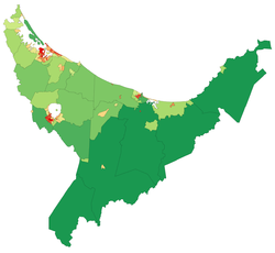 Population density map of the Bay of Plenty at the 2006 Census. Red = High, Green = Low.
Bay of Plenty Region had a population of 308,499 at the
2018 New Zealand census
, an increase of 40,758 people (15.2%) since the
2013 census
, and an increase of 51,120 people (19.9%) since the
2006 census
. There were 110,919 households, comprising 150,366 males and 158,133 females, giving a sex ratio of 0.95 males per female.
The percentage of people born overseas was 18.6, compared with 27.1% nationally.
Although some people chose not to answer the census's question about religious affiliation, 49.9% had no religion, 34.6% were
Christian
, 3.8% had
M?ori religious beliefs
, 1.6% were
Sikh
, 1.1% were
Hindu
, 0.3% were
Muslim
, 0.5% were
Buddhist
and 1.3% had other religions.
[16]
Of those at least 15 years old, 43,086 (17.6%) people had a bachelor's or higher degree, and 46,263 (18.9%) people had no formal qualifications. The median income was $29,100, compared with $31,800 nationally. 35,295 people (14.4%) earned over $70,000 compared to 17.2% nationally. The employment status of those at least 15 was that 114,264 (46.8%) people were employed full-time, 37,503 (15.4%) were part-time, and 10,926 (4.5%) were unemployed.
[17]
The Bay of Plenty is the fifth-most populous region in New Zealand, accounting for 6.8% of the national population.
[1]
The coast is dotted with several sizeable settlements, the largest of which is the conurbation of the city of Tauranga and its neighbour
Mount Maunganui
in the west. The town of Whakat?ne is located in the centre of the coast. Other towns of note include
Waihi Beach
,
Katikati
,
Maketu
,
Pukehina Beach
and
?p?tiki
.
Most of the population along the coast is concentrated in the western and central parts of the shore; the eastern part is sparsely populated hill country. The region has the third-highest regional population density in New Zealand, with only the 11th-largest land area. The major population centres are
Tauranga
,
Rotorua
and
Whakat?ne
.
Significant
horticultural
,
forestry
and
tourism
industries are well established in the region. However, the Bay of Plenty is the third-most economically deprived region in New Zealand, with the eastern districts being among the least economically developed in the country.
[6]
However, in 2011 Business & Economic Research Limited (BERL) identified the Bay of Plenty as one of the top performing regions in economic development, ranking second behind Auckland. It had the highest employment and GDP growth for 2011 and had the fastest growing medium term GDP. Tauranga, the region's largest commercial centre, was named New Zealand's top city for economic performance for the 2011 year.
Urban areas
[
edit
]
Urban areas in Bay of Plenty (pop. >1000)
| Name
|
Population
(June 2023)
[1]
|
% of region
|
| Tauranga
|
161,800
|
45.7%
|
| Rotorua
|
58,900
|
16.6%
|
| Whakat?ne
|
16,850
|
4.8%
|
| Te Puke
|
10,250
|
2.9%
|
| Kawerau
|
7,820
|
2.2%
|
| Katikati
|
5,800
|
1.6%
|
| ?p?tiki
|
5,350
|
1.5%
|
| Ngongotah?
|
5,230
|
1.5%
|
| ?mokoroa
|
4,770
|
1.3%
|
| ?hope
|
3,270
|
0.9%
|
| Waihi Beach
|
2,780
|
0.8%
|
| Murupara
|
2,060
|
0.6%
|
| Edgecumbe
|
1,820
|
0.5%
|
Ethnicity/identity
[
edit
]
Largest groups of overseas-born residents
[18]
| Nationality
|
Population (2018)
|
| England
|
14,817
|
| India
|
6,393
|
| Australia
|
5,562
|
| South Africa
|
4,299
|
| Philippines
|
2,703
|
| China
|
1,848
|
| Scotland
|
1,770
|
| Netherlands
|
1,563
|
| United States of America
|
1,479
|
| South Korea
|
1,434
|
In the 2018 census, ethnicities were 73.6% European/P?keh?, 29.1% M?ori, 3.5% Pacific peoples, 7.2% Asian, and 1.8% other ethnicities. People may identify with more than one ethnicity.
Only 18.6% of the regional population was born overseas, compared with 27.1% nationally. English is the most widely spoken language.
Te Reo M?ori
is the most common minority language, spoken by 8.6% of the population, compared with 4.0% nationally.
[17]
Economy
[
edit
]
The subnational gross domestic product (GDP) of Bay of Plenty was estimated at NZ$17.24 billion in the year to March 2019, 5.7% of New Zealand's national GDP. The subnational GDP per capita was estimated at $53,700 in the same period. In the year to March 2018, primary industries contributed $1.89 billion (11.6%) to the regional GDP, goods-producing industries contributed $3.24 billion (20.0%), service industries contributed $9.72 billion (59.8%), and taxes and duties contributed $1.39 billion (8.6%).
[19]
 The
Port of Tauranga
is the largest port in the country by cargo volume.
The
Port of Tauranga
is the largest port in the country by cargo volume.
Agriculture
,
natural resources
and
tourism
are the major industries. Most (96 per cent) of the region is defined as 'rural', with 22% of land usage representing farm land and 38% representing nature reserve land.
[6]
The most common agricultural land uses are
horticulture
,
dairy
,
grazing
and
sheep
farming. The region has over 11,500 hectares of horticultural land, predominantly producing
kiwifruit
and
avocadoes
.
[20]
The region also has an abundance of coastal, forestry and geothermal resources. Forestry emerged as a vital industry in the 1950s, with radiata pine being planted during the early 20th century. Forestry is commercially planted and managed, mostly using planted foreign tree species, and timber is sent to the
Port of Tauranga
for export. Geothermal activity is a source of tourism, and geothermal energy is emerging as a major regional source of electricity. Tourism is the other notable industry, accounting for 15% of the region's GDP from March 2000 to 2004.
[21]
Overall economic growth in the Bay of Plenty averaged 2.1% between March 2000 and 2004, compared with the national rate of 3.5%, although per capita
real GDP
growth in the five years to March 2003 matched the national growth rate at an averaged 2.3%.
[21]
In the 2013 Census, the median annual income was $26,200, below the national median of $28,500. Further, 39.3% of people aged 15 years or older earned an annual income of less than $20,000, compared with 38.2% of people nationally.
[22]
Unemployment was at 9.0% of people 15 years or older, compared with 7.1% nationally.
[23]
Tourism
[
edit
]
The Bay of Plenty Region is a popular holiday destination due to the warm and sunny summer climate and public beaches. The region received over 645,000 tourists in 2003, equivalent to one in three
visitors to New Zealand
coming to the region.
[21]
Rotorua is a popular destination for international visitors, in particular the surrounding geothermal areas and M?ori cultural centres. Tauranga is a popular domestic tourism destination, and also becoming popular internationally.
Whale watching
has become a popular attraction as the number of whales such as
blue whales
and
humpback whales
migrating into bay waters began to recover.
[24]
Transport
[
edit
]
The Bay of Plenty Region has 227 kilometres (141 mi) of rail network and 4,460 kilometres (2,770 mi) of roads.
[6]
The main rail line in the region is the
East Coast Main Trunk Railway
, which extends from
Hamilton
in the
Waikato
region to Kawerau via Tauranga, with the Murupara Branch Railway extending the Kawerau terminus to Murupara, and the Mount Maunganui Branch connecting the Mount Maunganui terminus with the East Coast Main Trunk. Rail networks in the region are used exclusively for freight. The hub of regional economic activity is the Port of Tauranga, with well-established rail and road connections to other parts of the region. Three commercial airports also operate in the Bay of Plenty:
Tauranga Airport
,
Rotorua Airport
and
Whakatane Airport
.
Car travel remains the dominant form of transport in the region. In 2002, the number of vehicles owned in the region was 189,000, with an average of 1.51 vehicles per household.
[6]
Public transport bus services exist only in Tauranga and Rotorua. Significant growth in the Western Bay of Plenty District has seen increased strain on road infrastructure, particularly with increasing traffic congestion in Tauranga. Due to this growth, a new highway network is being planned and constructed in Tauranga to join with its current network spanning on the western side of the city. The
NZ Transport Agency
, in conjunction with Environment Bay of Plenty, Tauranga City and the Western Bay of Plenty District Councils, is planning to build an Eastern Motorway bypassing Te Puke, a Western Motorway bypassing
?mokoroa
and a smaller Southern Motorway.
[25]
Sport
[
edit
]
The Bay of Plenty is represented in several domestic sporting competitions. The
Bay of Plenty Rugby Union
oversees the
Bay of Plenty Steamers
, who play in the
Mitre10 Cup
. The Steamers are also a feeder club for the
Chiefs
who play in the
Super Rugby
competition. The
Waikato/Bay of Plenty Magic
compete in the
ANZ Championship
in
netball
, having previously played in the
National Bank Cup
.
Bay of Plenty
also makes up a part of the
Northern Districts
cricket region and the Midlands hockey region.
Media
[
edit
]
Magazines
[
edit
]
- Plenty Magazine
- UNO. Magazine
- Focus magazine
Newspapers
[
edit
]
- Weekend Sun/SunLive
- Bay of Plenty Times
- Rotorua Daily Post
- Te Puke Times
- Opotiki News
- Whakatane Beacon
Radio stations
[
edit
]
Television
[
edit
]
- TV Central (Freeview Channel 30) ? Bay of Plenty & Waikato (shut down in April 2015)
- TV Rotorua-Rotorua (shut down in December 2013)
- Geyser Television-Rotorua (shut down in December 2013)
Notable people
[
edit
]
- Te Purewa
(??1842?), tribal leader, war leader and peacemaker
- Maharaia Winiata
(1912?1960), a New Zealand tribal leader, Methodist minister, teacher, anthropologist, broadcaster and community leader
Sister provinces
[
edit
]
See also
[
edit
]
References
[
edit
]
- ^
a
b
c
d
"Subnational population estimates (RC, SA2), by age and sex, at 30 June 1996-2023 (2023 boundaries)"
.
Statistics New Zealand
. Retrieved
25 October
2023
.
(regional councils);
"Subnational population estimates (TA, SA2), by age and sex, at 30 June 1996-2023 (2023 boundaries)"
.
Statistics New Zealand
. Retrieved
25 October
2023
.
(territorial authorities);
"Subnational population estimates (urban rural), by age and sex, at 30 June 1996-2023 (2023 boundaries)"
.
Statistics New Zealand
. Retrieved
25 October
2023
.
(urban areas)
- ^
"Regional gross domestic product: Year ended March 2022"
.
Statistics New Zealand
. 24 March 2023
. Retrieved
4 April
2023
.
- ^
"Sub-national HDI - Area Database - Global Data Lab"
.
hdi.globaldatalab.org
. Retrieved
18 February
2023
.
- ^
Toi
is supposed to be one of the first inhabitants of the region
- ^
a
b
Quickstats about Bay of Plenty Region
- ^
a
b
c
d
e
Environment Bay of Plenty (September 2004).
"Bay of Plenty Regional Land Transport Strategy"
(PDF)
. pp. 15?32. Archived from
the original
(PDF)
on 11 April 2008
. Retrieved
28 February
2008
.
- ^
"Bay of Plenty ? New Zealand Travel"
.
newzealandtravel.org
.
- ^
"Our Region"
. Environment Bay of Plenty. Archived from
the original
on 18 February 2008
. Retrieved
3 March
2008
.
- ^
"Mighty River Power media release: Generation Equipment Arriving at Kawerau"
. 18 October 2007. Archived from
the original
on 9 October 2008
. Retrieved
23 June
2008
.
- ^
McKinnon, Malcolm (27 September 2007).
"Bay of Plenty"
.
Te Ara ? the Encyclopedia of New Zealand
.
Archived
from the original on 20 March 2008
. Retrieved
25 February
2008
.
- ^
"Climate Change"
. Environment Bay of Plenty. Archived from
the original
on 13 February 2008
. Retrieved
3 March
2008
.
- ^
Mullan, Brett; Tait, Andrew; Thompson, Craig (21 September 2007).
"Regional Climate"
.
Te Ara ? the Encyclopedia of New Zealand
.
Archived
from the original on 11 April 2008
. Retrieved
7 March
2008
.
- ^
"ArcGIS Web Application"
.
statsnz.maps.arcgis.com
. Retrieved
26 February
2022
.
- ^
a
b
"2023 Census national and subnational usually resident population counts and dwelling counts"
(Microsoft Excel)
. Stats NZ - Tatauranga Aotearoa
. Retrieved
29 May
2024
.
- ^
"2001 Census: Regional summary"
.
archive.stats.govt.nz
. Archived from
the original
on 29 September 2020
. Retrieved
28 April
2020
.
- ^
"Religious affiliation (total responses) by age group and sex, for the census usually resident population count, 2006, 2013, and 2018 Censuses (RC, TA, SA2, DHB"
. Statistics New Zealand.
- ^
a
b
"Statistical area 1 dataset for 2018 Census"
. Statistics New Zealand. March 2020. Bay of Plenty Region (04).
2018 Census place summary: Bay of Plenty Region
- ^
"Birthplace (detailed), for the census usually resident population count, 2006, 2013, and 2018 Censuses (RC, TA, SA2, DHB)"
. Statistics New Zealand.
- ^
"Regional gross domestic product: Year ended March 2019 | Stats NZ"
.
www.stats.govt.nz
. Retrieved
21 May
2020
.
- ^
"Fresh Facts: New Zealand Horticulture"
(PDF)
.
Plant & Food Research
. 2018.
ISSN
1177-2190
.
- ^
a
b
c
New Zealand Institute of Economic Research (1 November 2005).
"Bay of Plenty Economic Profile"
.
Regional Economic Performance: Final Report
. New Zealand Ministry of Economic Development.
Archived
from the original on 4 April 2008
. Retrieved
28 February
2008
.
- ^
2013 Census QuickStats about a place (Income) : Bay of Plenty Region
- ^
2013 Census QuickStats about a place (Work) : Bay of Plenty Region
- ^
"Kim Westerskov Photography"
. Archived from
the original
on 1 April 2016
. Retrieved
27 April
2014
.
- ^
"Integrated Transport Strategy for Tauranga"
(PDF)
. Tauranga City Council. Archived from
the original
(PDF)
on 15 October 2008
. Retrieved
21 April
2008
.
- ^
"Radio FM ? Bay of Plenty ? Radio Stations NZ ? Easy Listening Rock Hits"
.
radiofm.co.nz
.
External links
[
edit
]