Natural submerged sandbank that rises from a body of water to near the surface
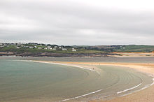
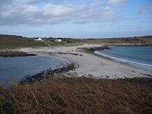 Sandbar between
St Agnes
and
Gugh
on the
Isles of Scilly
, off the coast of
Cornwall
,
England
,
United Kingdom
Sandbar between
St Agnes
and
Gugh
on the
Isles of Scilly
, off the coast of
Cornwall
,
England
,
United Kingdom
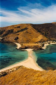 A tidal sandbar connecting the islands of
Waya
and Wayasewa of the
Yasawa Islands
,
Fiji
A tidal sandbar connecting the islands of
Waya
and Wayasewa of the
Yasawa Islands
,
Fiji
 Sandbar between Nosy Iranja Be and Nosy Iranja Kely
(
Nosy Iranja
,
Madagascar
)
In
oceanography
,
geomorphology
, and
geoscience
, a
shoal
is a natural submerged
ridge
,
bank
, or bar that consists of, or is covered by,
sand
or other unconsolidated material, and rises from the bed of a
body of water
close to the surface or above it, which poses a danger to navigation. Shoals are also known as
sandbanks
,
sandbars
, or
gravelbars
. Two or more shoals that are either separated by shared
troughs
or interconnected by past or present sedimentary and hydrographic processes are referred to as a
shoal complex
.
[1]
[2]
The term
shoal
is also used in a number of ways that can be either similar to, or quite different from, how it is used in geologic, geomorphic, and oceanographic literature. Sometimes, the term refers to either any relatively shallow place in a
stream
,
lake
,
sea
, or other body of water; a rocky area on the
seafloor
within an area mapped for navigation purposes; or, a growth of vegetation on the bottom of a deep lake, that occurs at any depth, or is used as a verb for the process of proceeding from a greater to a lesser depth of water.
[2]
Description
[
edit
]
Shoals are characteristically long and narrow (linear) ridges. They can develop where a
stream
,
river
, or
ocean current
promotes
deposition
of
sediment
and
granular material
, resulting in localized shallowing (shoaling) of the water. Marine shoals also develop either by the in-place drowning of barrier islands as the result of episodic
sea level rise
or by the erosion and submergence of inactive
delta lobes
.
Shoals can appear as a
coastal landform
in the
sea
, where they are classified as a type of
ocean bank
, or as
fluvial landforms
in rivers, streams, and
lakes
.
A shoal?sandbar may seasonally separate a smaller body of water from the sea, such as:
The term
bar
can apply to
landform
features spanning a considerable range in size, from a length of a few meters in a small stream to marine depositions stretching for hundreds of kilometers along a coastline, often called
barrier islands
.
Composition
[
edit
]
They are typically composed of
sand
, although they could be of any granular matter that the moving water has access to and is capable of shifting around (for example,
soil
,
silt
,
gravel
,
cobble
,
shingle
, or even
boulders
). The
grain size
of the material comprising a bar is related to the size of the waves or the strength of the currents moving the material, but the availability of material to be worked by waves and currents is also important.
Formation
[
edit
]
Wave shoaling
is the process when
surface waves
move towards shallow water, such as a beach, they slow down, their
wave height
increases and the
distance
between waves decreases. This behavior is called
shoaling
, and the waves are said to shoal. The waves may or may not build to the point where they
break
, depending on how large they were to begin with, and how steep the slope of the beach is. In particular, waves shoal as they pass over submerged sandbanks or reefs. This can be treacherous for boats and ships.
Shoaling can also
refract
waves, so the waves change direction. For example, if waves pass over a sloping
bank
which is shallower at one end than the other, then the shoaling effect will result in the waves slowing more at the shallow end. Thus, the wave fronts will refract, changing direction like light passing through a prism. Refraction also occurs as waves move towards a beach if the waves come in at an angle to the beach, or if the beach slopes more gradually at one end than the other.
Types
[
edit
]
 Donuzlav
, Crimea, separated by a
peresyp
from the
Black Sea
Donuzlav
, Crimea, separated by a
peresyp
from the
Black Sea
Sandbars and longshore bars
[
edit
]
 Amanohashidate
in
Miyazu
,
Kyoto Prefecture
,
Japan
Amanohashidate
in
Miyazu
,
Kyoto Prefecture
,
Japan
 White Island
in
Camiguin
, Philippines
White Island
in
Camiguin
, Philippines
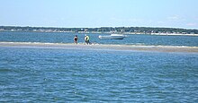 A sandbar off
Suffolk County
,
Long Island
,
New York
, US, August 2006.
A sandbar off
Suffolk County
,
Long Island
,
New York
, US, August 2006.
Sandbars, also known as a trough bars, form where the waves are breaking, because the breaking waves set up a shoreward current with a compensating counter-current along the bottom. Sometimes this occurs seaward of a
trough
(marine landform).
Sand carried by the offshore moving bottom current is deposited where the current reaches the wave break.
[3]
Other longshore bars may lie further offshore, representing the break point of even larger waves, or the break point at low tide.
Peresyp
[
edit
]
In Russian tradition of
geomorphology
, a
peresyp
is a sandbar that rises above the water level (like a
spit
) and separates a
liman
or a
lagoon
from the sea. Unlike
tombolo
bars, a
peresyp
seldom forms a contiguous strip and usually has one or several channels that connect the liman and the sea.
[4]
Harbor and river bars
[
edit
]
 The
Doom Bar
sand bank extends across the
River Camel
estuary in
Cornwall
, England, UK
The
Doom Bar
sand bank extends across the
River Camel
estuary in
Cornwall
, England, UK
A harbor or river bar is a sedimentary deposit formed at a
harbor
entrance or river mouth by the deposition of freshwater sediment or by the action of waves on the sea floor or on up-current beaches.
Where beaches are suitably mobile, or the river's
suspended
or
bed loads
are large enough, deposition can build up a sandbar that completely blocks a river mouth and dams the river. It can be a seasonally natural process of
aquatic ecology
, causing the formation of
estuaries
and
wetlands
in the lower course of the river. This situation will persist until the bar is
eroded
by the sea, or the dammed river develops sufficient
head
to break through the bar.
The formation of harbor bars that prevent access for boats and shipping can be the result of:
Nautical navigation
[
edit
]
In a
nautical
sense, a
bar
is a shoal, similar to a
reef
: a shallow formation of (usually) sand that is a
navigation
or
grounding
hazard, with a depth of water of 6 fathoms (11 meters) or less. It therefore applies to a silt accumulation that shallows the entrance to or course of a river, or creek. A bar can form a dangerous obstacle to shipping, preventing access to the river or harbor in poor weather conditions or at some states of the
tide
.
Geological units
[
edit
]
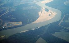 Shoals in the
Mississippi River
at
Arkansas
and
Mississippi
, USA.
Shoals in the
Mississippi River
at
Arkansas
and
Mississippi
, USA.
In addition to longshore bars discussed above that are relatively small features of a
beach
, the term
shoal
can be applied to larger geological units that form off a coastline as part of the process of coastal erosion, such as
spits
and
baymouth bars
that form across the front of
embayments
and
rias
. A
tombolo
is a bar that forms an
isthmus
between an
island
or offshore rock and a
mainland
shore.
In places of reentrance along a coastline (such as
inlets
,
coves
, rias, and bays), sediments carried by a
longshore current
will fall out where the current dissipates, forming a spit. An area of water isolated behind a large bar is called a lagoon. Over time, lagoons may silt up, becoming
salt marshes
.
In some cases, shoals may be precursors to beach expansion and dunes formation, providing a source of windblown sediment to augment such beach or dunes landforms.
[5]
Human habitation
[
edit
]
Since
prehistoric
times, humans have chosen some shoals as a site of habitation. In some early cases, the locations provided easy access to exploit marine resources.
[6]
In modern times, these sites are sometimes chosen for the water amenity or view, but many such locations are prone to storm damage.
[7]
[8]
An area in Northwest Alabama is commonly referred to as “
The Shoals
” by local inhabitants, and one of the cities,
Muscle Shoals
, is named for such landform and its abundance of
Mussels
.
See also
[
edit
]
Wikimedia Commons has media related to
Shoals
.
References
[
edit
]
- ^
Rutecki D, Nestler E, Dellapenna T, Pembroke A (2014).
"Understanding the Habitat Value and Function of Shoal/Ridge/Trough Complexes to Fish and Fisheries on the Atlantic and Gulf of Mexico Outer Continental Shelf"
.
Draft Literature Synthesis for the U.S. Dept. of the Interior, Bureau of Ocean Energy Management. Contract # M12PS00031
.
Bureau of Ocean Energy Management
(
DOI
). p. 116.
- ^
a
b
Neuendorf, K.K.E., J.P. Mehl Jr., and J.A. Jackson, eds. (2005)
Glossary of Geology
(5th ed.). Alexandria, Virginia, American Geological Institute. 779 pp.
ISBN
0-922152-76-4
- ^
W. Bascom, 1980.
Waves and Beaches
. Anchor Press/Doubleday, Garden City, New York. 366 p
- ^
Федченко Г.П, 'О самосадочной соли и соляных озерах Каспийского и Азовского бассейнов
1870,
p. 54
- ^
Mirko Ballarini,
Optical Dating of Quartz from Young Deposits
,
IOS Press
, 2006 146 pages,
ISBN
1-58603-616-5
- ^
C.Michael Hogan (2008)
Morro Creek
, ed. by Andy Burnham
- ^
Dick Morris (2008)
Fleeced
- ^
Jefferson Beale Browne
(1912)
Key West: The Old and the New
, published by The Record company