City in Kyushu, Japan
 Night view of downtown Amami
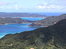 Beaches
Amami
(
奄美市
,
Amami-shi
)
is a
city
located on the island of
Amami ?shima
, in
Kagoshima Prefecture
,
Japan
. Amami is the most populated municipality on Amami ?shima. The most urban part of the municipality as well as the island's main port is a small city also known as
Naze
. As of 1 October 2020, the city has an estimated
population
of 41,390 and a
population density
of 134 persons per km². The total area is 308.15 km².
History
[
edit
]
The village of Naze was established on April 1, 1908. It was elevated to town status on October 1, 1922. As with all of the Amami Islands, the village came under the administration of the United States from July 1, 1946, to December 25, 1953. It was elevated to city status on July 1, 1946.
The modern city of Amami was established on March 20, 2006, from the merger of the city of Naze, the town of
Kasari
, and the village of
Sumiy?
(both from
?shima District
).
Geography
[
edit
]
Amami is bordered by the
East China Sea
to the north and the
Pacific Ocean
to the south. The Kasari area of the city is an exclave, separated from the main part of Amami by the town of
Tatsug?
.
Climate
[
edit
]
Amami has a
humid subtropical climate
(
Koppen climate classification
Cfa
) with long, hot, humid summers and mild winters. Precipitation is abundant throughout the year, with particularly heavy rainfall in May, June, August and September. The area is subject to frequent
typhoons
.
| Climate data for
Naze
, Amami (1991?2020 normals, extremes 1896?present)
|
| Month
|
Jan
|
Feb
|
Mar
|
Apr
|
May
|
Jun
|
Jul
|
Aug
|
Sep
|
Oct
|
Nov
|
Dec
|
Year
|
| Record high °C (°F)
|
28.1
(82.6)
|
28.2
(82.8)
|
30.4
(86.7)
|
32.1
(89.8)
|
33.7
(92.7)
|
36.3
(97.3)
|
37.3
(99.1)
|
36.9
(98.4)
|
34.9
(94.8)
|
33.0
(91.4)
|
31.0
(87.8)
|
28.6
(83.5)
|
37.3
(99.1)
|
| Mean daily maximum °C (°F)
|
17.7
(63.9)
|
18.3
(64.9)
|
20.4
(68.7)
|
23.1
(73.6)
|
26.2
(79.2)
|
29.4
(84.9)
|
32.3
(90.1)
|
32.0
(89.6)
|
30.4
(86.7)
|
27.0
(80.6)
|
23.5
(74.3)
|
19.6
(67.3)
|
25.0
(77.0)
|
| Daily mean °C (°F)
|
15.0
(59.0)
|
15.3
(59.5)
|
17.1
(62.8)
|
19.8
(67.6)
|
22.8
(73.0)
|
26.2
(79.2)
|
28.8
(83.8)
|
28.5
(83.3)
|
27.0
(80.6)
|
23.9
(75.0)
|
20.4
(68.7)
|
16.7
(62.1)
|
21.8
(71.2)
|
| Mean daily minimum °C (°F)
|
12.2
(54.0)
|
12.4
(54.3)
|
14.1
(57.4)
|
16.7
(62.1)
|
19.8
(67.6)
|
23.6
(74.5)
|
26.0
(78.8)
|
26.0
(78.8)
|
24.3
(75.7)
|
21.2
(70.2)
|
17.6
(63.7)
|
13.9
(57.0)
|
19.0
(66.2)
|
| Record low °C (°F)
|
4.4
(39.9)
|
3.1
(37.6)
|
4.7
(40.5)
|
6.6
(43.9)
|
9.4
(48.9)
|
13.9
(57.0)
|
18.8
(65.8)
|
19.6
(67.3)
|
15.3
(59.5)
|
11.2
(52.2)
|
8.2
(46.8)
|
6.1
(43.0)
|
3.1
(37.6)
|
| Average
precipitation
mm (inches)
|
184.1
(7.25)
|
161.6
(6.36)
|
210.1
(8.27)
|
213.9
(8.42)
|
278.1
(10.95)
|
427.4
(16.83)
|
214.9
(8.46)
|
294.4
(11.59)
|
346.0
(13.62)
|
261.3
(10.29)
|
173.6
(6.83)
|
170.4
(6.71)
|
2,935.7
(115.58)
|
| Average precipitation days
(≥ 1.0 mm)
|
15.1
|
13.6
|
14.4
|
12.7
|
13.7
|
16.2
|
10.4
|
13.7
|
14.8
|
12.8
|
10.6
|
13.8
|
161.8
|
| Average
relative humidity
(%)
|
68
|
70
|
70
|
73
|
77
|
80
|
77
|
78
|
78
|
75
|
72
|
69
|
74
|
| Mean monthly
sunshine hours
|
58.7
|
63.3
|
89.3
|
110.6
|
122.8
|
116.4
|
199.2
|
176.3
|
135.0
|
107.9
|
86.1
|
66.5
|
1,332.1
|
| Source:
Japan Meteorological Agency
[1]
[2]
|
Surrounding municipalities
[
edit
]
Transportation
[
edit
]
Airport
[
edit
]
Seaport
[
edit
]
Naze Port is a regional transportation hub, with frequent ferry service to Kagoshima, Tokyo, Kobe, and Osaka, as well as Okinawa, the other Amami islands, and
Tokara Islands
.
Highway
[
edit
]
Points of interest
[
edit
]
Sister cities
[
edit
]
Notable people from Amami
[
edit
]
References
[
edit
]
External links
[
edit
]
|
|---|
|
| Core city
| | |
|---|
| Cities
| |
|---|
| Districts
| | | ?shima Subprefecture
| |
|---|
| Kumage Subprefecture
| |
|---|
|
|---|
|
|
|---|
| International
| |
|---|
| Geographic
| |
|---|
| Academics
| |
|---|