Neighbourhood in Fatih, Istanbul, Turkey
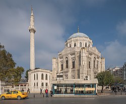 Pertevniyal Valide Sultan Mosque
in Aksaray.
Pertevniyal Valide Sultan Mosque
in Aksaray.
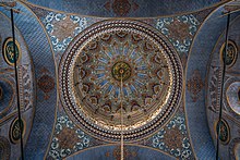 Interior of
Pertevniyal Valide Sultan Mosque
.
Interior of
Pertevniyal Valide Sultan Mosque
.
Aksaray
(literally "White Palace" in
Turkish
) is a neighbourhood in the municipality and district of
Fatih
,
Istanbul Province
,
Turkey
.
[1]
Its population is 8,541 (2022).
[2]
It is so named because it was founded by migrants from
Aksaray
in
central Turkey
, brought here in the 15th century by
Mehmet II
to repopulate the city after
its conquest
.
[3]
Aksaray is a mainly modern neighbourhood centred on a busy square. It was historically known as
Boos
, (
Latin
: Forum Bovis,
Greek
: ? Bο??, romanized: o Bous), It has a large population of migrants from the southeast of the country and many restaurants serve the cuisine of
?anlıurfa
,
Diyarbakır
and
Hatay
. More recently it has also acquired a large population of Syrian refugees who have introduced their own cuisine to the mix. There are many shops and hotels here.
To the east, Aksaray borders the textile-retailing neighbourhood of
Laleli
while to the west, along Millet Caddesi, lies Capa. To the south is
Yenikapı
and to the north
Fatih
. Busy Vatan Caddesi (AKA Adnan Menderes Bulvarı) runs northwest from Aksaray towards the
City Walls
, following the route of the lost
Lycos river
.
Attractions
[
edit
]
The Pertevniyal Valide Sultan Mosque
stands by the busy road junction near Aksaray tram stop. Squeezed in between Aksaray and Yusufpa?a is the smaller, older and much less conspicuous
Murad Pasha Mosque
, built in 1473 in the early Ottoman architectural style perfected in
Bursa
.
[4]
On Aksaray Square the wooden
Hindiler (Horhor) Tekkesi
has been rebuilt behind an austere stone fountain. The small
Camcılar (Glaziers)
Mosque
is also being rebuilt on the edge of the square.
A little way along Vatan Caddesi stands the
Fenari ?sa Mosque
which started life as the early 10th-century Byzantine Church of Constantine Lips.
[5]
Facing it across the road is the
Yavuz Sultan Selim Medrese
, a work of
Mimar Sinan
dating from 1549 now used as a clinic. Nearby is the tomb of one of Sultan
Selim I
's daughters,
?ah-ı Huban
, partially hidden by a stone schoolhouse. It, too, was designed by
Mimar Sinan
.
[6]
Transport
[
edit
]
Aksaray is the starting point for the M1
line
which runs to the
Ataturk International Airport
, now no longer in use for passenger aircraft. The Otogar stop on the line serves the large inter-city bus terminus at
Esenler
.
Aksaray is also served by the T1 tram line.
Hub for sex trafficking
[
edit
]
Aksaray is said to be a hub for the
sex trafficking
of young women from
Romania
,
Moldova
and
Ukraine
.
[7]
Some reports in the Turkish media have claimed that the neighbourhood is especially prone to prostitution because it is a "no man's land" between two adjoining police jurisdictions,
Fatih
and
Eminonu
.
[8]
References
[
edit
]
Sources
[
edit
]
- Mamboury, Ernest (1953).
The Tourists' Istanbul
. Istanbul: Cituri Biraderler Basımevi.
External links
[
edit
]
|
|---|
| Neighbourhoods
|
- Aksaray
- Ak?emsettin
- Alemdar
- Ali Ku?cu
- Atikali
- Ayvansaray
- Balabana?a
- Balat
- Beyazıt
- Binbirdirek
- Cankurtaran
- Cerrahpa?a
- Cibali
- Demirta?
- Dervi? Ali
- Emin Sinan
- Hacı Kadın
- Haseki Sultan
- Hırka-? ?erif
- Hobyar
- Hoca Gıyasettin
- Hocapa?a
- ?skenderpa?a
- Kalenderhane
- Karagumruk
- Katip Kasım
- Kemalpa?a
- Koca Mustafapa?a
- Kucuk Ayasofya
- Mercan
- Mesihpa?a
- Mevlanakapı
- Mimar Hayrettin
- Mimar Kemalettin
- Mollafenari
- Mollagurani
- Molla Husrev
- Muhsine Hatun
- Ni?anca
- Rustempa?a
- Sarac ?shak
- Sarıdemir
- ?ehremini
- ?ehsuvar Bey
- Seyyid Omer
- Silivrikapı
- Suleymaniye
- Sultan Ahmet
- Sumbul Efendi
- Sururi
- Tahtakale
- Tayahatun
- Topkapı
- Yavuz Sinan
- Yavuz Sultan Selim
- Yedikule
- Zeyrek
|
|---|
| Quarters
| |
|---|
| Landmarks
| |
|---|
| Transport
| |
|---|
| Education
| |
|---|
| Metro Stations
| |
|---|
|