Major long-distance road in Wales
The
A470
(also named the
Cardiff to Glan Conwy Trunk Road
)
[1]
is a
trunk road
in
Wales
. It is the country's longest road at 186 miles (299 km) and links the capital
Cardiff
on the south coast to
Llandudno
on the north coast.
[2]
While previously one had to navigate the narrow roads of
Llanidloes
and
Dolgellau
, both these market towns are now bypassed due to extensive road modernisation
[
when?
]
. The 26 miles (42 km) from Cardiff Bay to
Merthyr Tydfil
are mainly
dual carriageway
, but most of the route from north of Merthyr to Llandudno is
single carriageway
.
Route
[
edit
]
National parks
[
edit
]
The road travels through two of the
national parks of Wales
: the
Brecon Beacons
, and
Snowdonia National Park
starting just south of
Dinas Mawddwy
.
Cardiff Bay ? Merthyr Tydfil
[
edit
]
 North Road (Cardiff) tidal flow system, a 3-lane single carriageway
The southernmost point of the route is in
Cardiff Bay
, outside the
Wales Millennium Centre
. It runs up
Lloyd George Avenue
(this was previously Collingdon Road, and the A470 previously ran along the parallel
Bute Street
), and continues along St. Mary Street in central
Cardiff
. The road then becomes North Road, and after a
tidal flow
system running to
Maindy
and then goes over the flyover at the
Gabalfa
interchange of the
A48
and the
A469
. It becomes an urban dual-carriageway along Manor Way, with a 30 mph (48 km/h) speed limit and with many traffic-signalled crossings. It passes without interruption under the
M4
at the giant
Coryton
roundabout. For the next 15 miles (24 km) it is a modern high-speed dual carriageway by-passing
Tongwynlais
and
Castell Coch
,
Taff's Well
, to
Pontypridd
. Heading north to
Abercynon
, the road now follows the route of the
Taff Vale Railways
Llancaiach Branch
to Quakers Yard roundabout,
[3]
where it is joined by the A4059 from
Abercynon
,
Aberdare
and
Hirwaun
; the
A472
from
Ystrad Mynach
and
Pontypool
finally the A4054 from
Quakers Yard
, and
Merthyr Tydfil
.
From Quakers Yard roundabout (locally known as "Fiddlers Elbow"), 5.5 miles (8.9 km) of dual carriageway takes the road to the Pentrebach roundabout where the A4060 links, and then to the Merthyr Tydfil roundabout where the road meets the
A465
and the dual carriageway ends. A twisting section alongside the
Taf Fawr
reservoirs of
Llwyn-on
,
Cantref
and
Beacons
takes the road to its highest point at
Storey Arms
on the pass over the
Brecon Beacons
before a long descent to
Brecon
.
Merthyr Tydfil ? Builth Wells
[
edit
]
 The A470 at
Bwlch Oerddrws
[
cy
]
, between Dinas Mawddwy and Dolgellau
The A470 at
Bwlch Oerddrws
[
cy
]
, between Dinas Mawddwy and Dolgellau
The remainder of the route north of Brecon consists of older routes now renamed "A470". This artificiality is apparent as a driver following the entire route north to south must diverge from the main line of respective stretches of road no fewer than five times. A short three lane stretch heads north east before a sharp left turn is required to stay on the road. From this point on the road becomes narrow and twisting and overtaking is problematic except at a few straight sections. Another sharp left turn at a stop sign in
Llyswen
takes the road alongside the
River Wye
into
Builth Wells
.
Builth Wells ? Mallwyd
[
edit
]
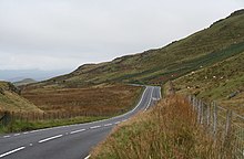
 The A470 snaking across Bwlch Oerddrws seen from
Maesglase
The A470 snaking across Bwlch Oerddrws seen from
Maesglase
The road continues to follow the Wye to the busy crossroads where it meets the A44 in the centre of
Rhayader
. On reaching
Llangurig
, a right turn outside the village takes the road past
Llanidloes
and through
Llandinam
, the birthplace of
David Davies
and now the headquarters of
Girl Guides Wales
. Another anomalous left turn at a
level crossing
sets the path for
Caersws
,
Carno
and
Llanbrynmair
. Just beyond the village of
Talerddig
the road descends and crosses under the
Shrewsbury?Aberystwyth railway line
. The long descent towards
Commins Coch
is a relatively new stretch of road that replaced a set of road-works that had traffic light controlled single lane working for over 10 years because of unstable ground conditions. The river bridge at
Commins Coch
is so narrow and set at such an angle that only one vehicle at a time can pass. At
Cemmaes Road
the road joins the
A487
at a roundabout. A right turn at the roundabout takes the road on to
Mallwyd
where the
A458
joins at yet another roundabout.
Mallwyd ? Llandudno
[
edit
]
The country becomes more forested and the road climbs up through
Dinas Mawddwy
and then steeply up the eastern foot-hills of
Cadair Idris
before dropping down to the
Dolgellau
by-pass. More sharp twists and turns in the forestry and through the village of
Ganllwyd
brings the road up onto the high plateau of the Cambrian dome where the road follows the ancient track of
Sarn Helen
Roman road passing the redundant nuclear power station at
Trawsfynydd
. A right turn beyond the power station takes the road on to
Ffestiniog
and
Blaenau Ffestiniog
before heading over the
Crimea Pass
to
Dolwyddelan
. A sharp left turn interrupts the A470 as it becomes the
A5
for a short distance towards
Betws-y-Coed
before turning right again back onto the A470 just before
Waterloo Bridge
. Passing down the valley of the
River Conwy
the road passes through
Llanrwst
,
Tal-y-Cafn
and
Glan Conwy
, at which point there is a dual roundabout that intersects with the
A55
North Wales Expressway before descending into
Llandudno
. The northernmost point of the route is in
Llandudno
itself at the sea front, where it meets the North Shore Parade, the
A547
.
Junctions
[
edit
]
This list is for the section between Cardiff and Merthyr Tydfil.
| A470 (T)
[4]
|
| Northbound exits
|
Junction
|
Southbound exits
|
Newport
,
Bridgend
 M4
,
Tongwynlais M4
,
Tongwynlais
 A4054 A4054
|
M4 Junction 32 ? Coryton Interchange
[5]
|
Start of A470 (T)
[
further explanation needed
]
|
| Taff's Well
,
Tongwynlais
A4054
,
Radyr
B4262
|
Taff's Well Interchange
[6]
|
Taff's Well
,
Tongwynlais
A4054
,
Radyr
B4262
|
Treforest Industrial Estate
,
Taff's Well
A4054
,
Caerphilly
 A468 A468
|
Nantgarw Interchange
[7]
|
Treforest Industrial Estate
,
Taff's Well
A4054
,
Caerphilly
A468
|
Treforest Industrial Estate
,
Taff's Well
A4054
,
Llantrisant
 A473 A473
|
Upper Boat Interchange
[8]
|
Treforest Industrial Estate
,
Taff's Well
A4054
,
Llantrisant
A473
|
| Llantrisant
(
A473
)
|
Glyntaff Interchange
[9]
|
No access
|
Pontypridd
,
Rhondda Valleys
 A4058 A4058
|
Broadway Interchange
[10]
|
No access
|
| No access
|
Bridge Street Interchange
[11]
|
Pontypridd
 A4223
,
Rhondda Valleys
(
A4058
), Ynys-y-bwl (
B4273
),
Llantrisant
(
A473
) A4223
,
Rhondda Valleys
(
A4058
), Ynys-y-bwl (
B4273
),
Llantrisant
(
A473
)
|
| Abercynon
B4275
|
Abercynon Interchange
[12]
|
No access
|
Mountain Ash
,
Aberdare
 A4059
,
Ystrad Mynach
https://www.roads.org.uk/motorway/a470/130
,
Aberfan
A4054 A4059
,
Ystrad Mynach
https://www.roads.org.uk/motorway/a470/130
,
Aberfan
A4054
|
Abercynon Roundabout
[13]
|
Mountain Ash
,
Aberdare
A4059
,
Ystrad Mynach
 A472 A472
|
Pentrebach
 A4060
,
Abergavenny
( A4060
,
Abergavenny
(
 A465
) A465
)
|
Abercanaid Roundabout
[14]
|
Pentrebach
A4060
,
Abergavenny
(
A465
)
|
Rhyd-y-car
 A4102 A4102
|
Orbit Roundabout
[15]
|
Rhyd-y-car
A4102
|
| Merthyr Tydfil
town centre
A4102
|
Swansea Road Roundabout
[16]
|
Merthyr Tydfil
town centre
A4102
|
| Neath
,
Abergavenny
A465
,
Brecon
A470
|
Cefn Coed Roundabout
[17]
|
Start of A470 (T)
|
1.000 mi = 1.609 km; 1.000 km = 0.621 mi
|
History
[
edit
]
 Taff's Well Interchange during construction in November 1971
Modern route
[
edit
]
The modern route of the A470 arose from a campaign in the 1970s by the
Western Mail
for a single route connecting North and South Wales, in the lead up to the
1979 Welsh devolution referendum
. It was successful, and in 1978, the Welsh Office discussed a potential course of the road roughly through the centre of the country, which was implemented the following year.
[18]
Original route
[
edit
]
The route from
Cardiff
to
Brecon
was the original A470.
[19]
It originally ran into Brecon town centre and joined the
A40 road
. The old A470 between the by-pass and the town, along Newgate Street, is now the B4601. A4062 was the number for the section from the junction of the A40 and the B4601 ? the Brecon (eastern) bypass to B4602 section. The B4601 was originally the A40 which ran through the town of Brecon. Similarly, the B4602 was originally the westernmost part of the A438.
 The A470 passing through Rhayader
Original road numbers
[
edit
]
Brecon ? Llangurig
[
edit
]
The A438 was the original number for the road from the junction with B4602 to the sharp left turn where A470 turns north in the vicinity of
Llanfilo
. The A438 continues on from there to
Hereford
and
Tewkesbury
. From north of Llanfilo to
Llyswen
was the A4073. A479 originally linked the A40 west of
Crickhowell
to the
A44 road
at
Rhayader
. The A479 now runs only from Crickhowell to Llyswen. The stretch from Rhayader to
Llangurig
was the A44. Officially, this is now part of the A470,
[20]
but some local signage shows A44/A470.
[
citation needed
]
Llangurig ? Mallwyd
[
edit
]
From Llangurig to Moat Lane (east of
Caersws
), it was once part of the A492, which originally ran from Llangurig to
Newtown
.
[21]
The section Moat Lane to Newtown has since been renumbered A489, and from Moat Lane to
Glantwymyn
the A470 replaced the A489 which ran all the way from
Machynlleth
to the
A49 road
north of
Craven Arms
in south
Shropshire
. Now the A489 designation applies to two roads separated by 17 miles (27 km) of the A470. The stretch between Glantwymyn to Mallwyd was called the A4084.
Dolgellau
[
edit
]
Originally starting at the Cross Foxes near
Dolgellau
the A458 now runs only from Mallwyd to
Shrewsbury
. It now starts at Mallwyd with the Mallwyd to Cross Foxes section being the A470. Cross Foxes to near Gellilydan (in the
Meirionydd
part of
Gwynedd
south of
Ffestiniog
) brings us to a complicated series of route renumbering. This stretch was originally the A487 which ran through Dolgellau town centre. The modern A470 bypasses the town using the line of the old
Ruabon ? Morfa Mawddach railway
.
Gellilydan ? Llandudno
[
edit
]
Gellilydan via Llan Ffestiniog to
Blaenau Ffestiniog
(Congl-y-Wal) was not originally allocated a number. The section from Blaenau Ffestiniog to
Betws-y-Coed
was the B4407, and from there to
Llandudno
was the A544.
[22]
By 1946, the A496 had become extended to Llandudno.
[23]
The section of road from Glan Conwy corner to Llandudno is a new well aligned direct route to Llandudno. The old A496 has been renumbered A547 between Glan Conwy and Llandudno Junction and A546 between Llandudno Junction and Llandudno. The A496 now numbers only the Dolgellau ? Blaenau Ffestiniog coast road.
Cultural references
[
edit
]
In 2014,
Cerys Matthews
presented a documentary on the A470 on
BBC Radio 4
, journeying from the north of the country to Cardiff Bay.
[24]
[25]
The programme described the road as "the
M1 motorway
of Wales", despite most of the road being rural single-carriageway, with Matthews stopping off at places like Llanrwst and Rhayader.
[26]
In March 2022, Arachne Press published
A470: Poems for the Road / Cerddi’r Ffordd
, a bilingual English and Welsh book of poems about the A470, edited by Sian Northey and Ness Owen.
[27]
Published on
St. David's Day
, by June of that year it had its second reprint.
[28]
Other references in Welsh popular culture include:
See also
[
edit
]
References
[
edit
]
External links
[
edit
]
|
|---|
Managed by the
North and Mid Wales
Trunk Road Agent
|
- Bangor - Chirk Trunk Road
(
A5
)
- London - Fishguard Trunk Road
(
A40
)
- Newtown - Aberystwyth Trunk Road
(
A44
)
- Holyhead - Chester Trunk Road
(
A55
)
- Shropshire Boundary - Mallwyd Trunk Road
(
A458
)
- Cardiff - Glan Conwy Trunk Road
(
A470
)
- Glanusk Park (Crickhowell) - Llyswen Trunk Road
(
A479
)
- Swansea - Manchester Trunk Road
(
A483
)
- Fishguard - Bangor Trunk Road
(
A487
)
- Newtown - Machynlleth Trunk Road
(
A489
)
- Dolgellau - South of Birkenhead Trunk Road
(
A494
)
|
|---|
Managed by the
South Wales
Trunk Road Agent
|
- M4 motorway
- M48 motorway
- A48(M) motorway
- London - Fishguard Trunk Road
(
A40
)
- Chepstow - Carmarthen Trunk Road
(
A48
)
- Newport - Worcester Trunk Road
(
A449
)
- Neath - Abergavenny Trunk Road
(
A465
)
- Chepstow - Monmouth Trunk Road
(
A466
)
- Cardiff - Glan Conwy Trunk Road
(
A470
)
- St Clears - Pembroke Dock Trunk Road
(
A477
)
- Swansea - Manchester Trunk Road
(
A483
)
- Fishguard - Bangor Trunk Road
(
A487
)
- Newport - Shrewsbury Trunk Road
(
A4042
)
- East of Abercynon - East of Dowlais Trunk Road
(
A4060
)
- Haverfordwest - Milford Haven Trunk Road
(
A4076
)
- A4232 Trunk Road (Capel Llanilltern ? Culverhouse Cross Link Road)
(
A4232
)
|
|---|
Related topics and
further information
| |
|---|
|
|
|---|
| Motorways and A roads
| | |
|---|
Pedestrian precincts
and commercial streets
| |
|---|
| Bus
| |
|---|
| Cycling
| |
|---|
| Railway lines
| |
|---|
| Railway operators
| |
|---|
| Major railway stations
| |
|---|
Other city
railway stations
| |
|---|
| Air
| |
|---|
| Water
| |
|---|
Proposed transport
network
| |
|---|
|
|
|---|
| Road
| | |
|---|
| Footpaths
| |
|---|
| Cycle routes
| |
|---|
Railway
stations
| |
|---|
|
|
|---|
| Roads
| | |
|---|
| Bus
| |
|---|
| Cycling
| |
|---|
| Railway lines
| |
|---|
| Railway stations
| |
|---|
|