Category 4 Atlantic hurricane in 1929
Hurricane Two
 |
|
| Formed
| September 22, 1929
(
1929-09-22
)
|
|---|
| Dissipated
| October 4, 1929
(
1929-10-05
)
|
|---|
|
| 1-minute sustained
(
SSHWS
/
NWS
)
|
| Highest winds
| 155 mph (250 km/h)
|
|---|
| Lowest pressure
| 924
mbar
(
hPa
); 27.29
inHg
|
|---|
|
| Fatalities
| 155 direct
|
|---|
| Damage
| $9.31 million (1929
USD
)
(U.S. damage only)
|
|---|
| Areas affected
| |
|---|
IBTrACS
 |
Part of the
1929 Atlantic hurricane season
|
The
1929 Bahamas hurricane
(also known as the
Great Andros Island Hurricane
) was a high-end
Category 4
tropical cyclone
whose intensity and slow forward speed led to catastrophic damage in
the Bahamas
in September 1929, particularly on
Andros
and
New Providence
islands. Its erratic path and a lack of nearby weather observations made the hurricane difficult to locate and forecast. The storm later made two
landfalls
in
Florida
, killing eleven but causing comparatively light damage. Moisture from the storm led to extensive
flooding
over the
Southeastern United States
, particularly along the
Savannah River
. Across its path from the Bahamas to the
mouth
of the
Saint Lawrence River
, the hurricane killed 155 people.
The storm's origins can be traced to
tropical wave
first noted near the
Cabo Verde
Islands on September 11, 1929. This tropical disturbance remained dormant as it tracked west until September 18, when an associated area of thunderstorms
developed
into a
tropical depression
northeast of
Puerto Rico
. Gradually strengthening, the depression reached
tropical storm
strength on September 22 and hurricane strength on September 23. Beginning on September 24, the storm took a slow and southwestward path through the Bahamas, passing over
Nassau
and Andros Island between September 25?26 with
maximum sustained winds
of 145 mph (230 km/h).
[nb 1]
This southwestward trajectory was unprecedented for the islands. The storm then curved west and struck the
Florida Keys
at
Key Largo
on September 28 with winds of 115 mph (185 km/h). Two days later, the cyclone moved ashore
Apalachicola, Florida
, as a minimal hurricane shortly before transitioning into an
extratropical cyclone
. This system tracked northeast along the interior of the
East Coast of the United States
before dissipating near the Saint Lawrence River on October 4.
Poorly-built structures and ships were destroyed throughout the Bahamas. Andros Island was within the envelope of the storm's
hurricane-force
winds and
storm surge
for two days. Parts of the island were inundated by a 12 ft (3.7 m) surge that advanced 20 mi (32 km) inland, wiping out all crops and most fruit trees and livestock. A wind gust of 164 mph (264 km/h) was measured in Nassau, which also experienced the calm of the hurricane's
eye
for two hours. An estimated 73% of the city's homes and businesses sustained damage, leaving more than 5,000 people without homes. The hurricane was a heavy blow to the declining
sponge
industry on the islands. Following the storm, wild birds and crops were brought from the
Caribbean
to replenish their losses in the Bahamas. New
building codes
were enacted after the 1929 storm to prevent similarly extensive destruction.
A 6?9 ft (1.8?2.7 m) storm surge battered the
Florida Keys
, washing out highways and sinking small fishing boats. At least five
tornadoes
struck Florida, representing some of the first verified reports of
tornadoes caused by a tropical cyclone
. One impacted
Fort Lauderdale
's business center and caused $100,000 in damage.
[nb 2]
The Apalachicola waterfront sustained heavy damage from the storm's final landfall, including the loss of nearly all wharves. Widespread flooding occurred throughout
Georgia
and
The Carolinas
due to the continuous influx of moisture from the slowly-moving hurricane. A maximum rainfall total of 20.0 in (510 mm) was registered in
Glennville, Georgia
. The
Savannah River
reached a record
stage
of 46.1 ft (14.1 m) at
Augusta, Georgia
, breaching a levee and inundating much of the surrounding floodplain. The damage toll in the United States totaled to at least $9.31 million.
Background
[
edit
]
The Bahamas
is an archipelago especially vulnerable to
tropical cyclones
due to its position within the
storm tracks
of Atlantic hurricanes. Approximately 80% of its landmass has an elevation within 5 ft (1.5 m) of
mean sea level
.
[3]
Before 1929, the islands were hit by hurricanes in
1866
,
1899
, and
1926
that each killed over a hundred people.
The Bahamas, at the time a
Crown colony
, was adversely affected by the
Great Depression
. The economic downturn was further compounded by a sharp reduction in demand in the colony's
sisal
and
sponge
after
World War I
, a weak
Pound sterling
relative to the
American dollar
, and a severe drought in the central and southern islands.
Hurricane warning systems in the Bahamas were mostly non-existent in 1929; islanders relied on personal weather instruments or the behavior of clouds, tides, and fauna to assess risk.
District officers
were responsible for informing others of a storm's approach based on the
barometer
housed in their homes.
Flags signaling a hurricane's approach were present at Bahamian forts but were raised arbitrarily and inconsistently.
[7]
Meteorological history
[
edit
]
 Map plotting the storm's track and intensity, according to the Saffir?Simpson scale
Map key
Tropical depression (≤38 mph, ≤62 km/h)
Tropical storm (39?73 mph, 63?118 km/h)
Category 1 (74?95 mph, 119?153 km/h)
Category 2 (96?110 mph, 154?177 km/h)
Category 3 (111?129 mph, 178?208 km/h)
Category 4 (130?156 mph, 209?251 km/h)
Category 5 (≥157 mph, ≥252 km/h)
Unknown
The hurricane can be traced back to a complex of disturbed weather near
Cabo Verde
on September 11, producing showers across the open waters of the Atlantic and directed westward by the
Azores High
. The disturbance remained a weak
tropical wave
for much of its early history, but over time gradually organized.
By September 15,
weather maps
began to notate the system as a
trough of low pressure
north of the
Lesser Antilles
.
[9]
A portion of this trough split off and moved northwest towards the
South Atlantic states
while the remaining disturbance continued to organize,
becoming a
tropical depression
approximately 355 mi (570 km) northeast of
San Juan, Puerto Rico
, by September 18.
[9]
[10]
Over the next three days, the system remained a tropical depression as it tracked slowly west. It reached
tropical storm
strength by September 22 while 400 mi (640 km) northwest of San Juan and curved northwest.
[10]
Continuing to strengthen, the storm reached hurricane intensity the following day.
[10]
On September 24, the hurricane began to slowly move southwest towards the
Bahamas
, traversing the Northeast Providence Channel.
Until that point, few observations probed the core of the hurricane on its approach of the islands due to its small size. In 2010, the
Atlantic hurricane reanalysis project
determined the storm had been
rapidly intensifying
during this period.
[9]
On September 25, the steamship
Potomac
measured a central
air pressure
of 924
mbar
(
hPa
; 27.30
inHg
), suggesting
wind speeds
of 155 mph (250 km/h): a high-end
Category 4 hurricane
on the
Saffir?Simpson scale
.
[9]
At 00:30
UTC
on September 25,
the intense hurricane passed over
Nassau
with sustained winds of 145 mph (230 km/h);
[9]
the capital city was within the calm of the
eye
for two hours. The next day, the storm crossed
Andros Island
south of
Fresh Creek
, moving at 2?3 mph (3.2?4.8 km/h),
and afterwards curved slowly towards the west-northwest over the
Florida Straits
towards
Florida
.
[9]
A
high-pressure area
associated with cool temperatures over the United States had been responsible for the sudden southwest trajectory over the Bahamas.
The
United States Weather Bureau
remarked that the storm's track was "one of the most erratic and abnormal during the last 50 years", with both the slow movement and inadequate observations contributing in the agency's difficulty in locating the center of the storm.
The hurricane's winds lessened while its size grew on its Florida approach, and on the morning of September 28, it crossed the
Florida Keys
near
Key Largo
with winds of 115 mph (185 km/h). A pressure of 948 mbar (hPa; 27.99 inHg) was estimated within a 10-minute lull near the eye's edge at Key Largo.
[9]
Further weakening occurred as the hurricane accelerated northwestward into the eastern
Gulf of Mexico
, continuing this heading for two days.
[10]
On September 30, the storm made an unexpectedly sharp turn towards the northeast,
making
landfall
near
Panama City, Florida
, near midnight as a low-end hurricane with winds of 80 mph (130 km/h).
[9]
Positioned near a steep
temperature gradient
, the storm quickly transitioned into an
extratropical cyclone
on October 1 shortly after landfall with cold air wrapping around the circulation.
[9]
The extratropical cyclone quickly moved northeast across the
Eastern Seaboard
, eventually dissipating near the
Saint Lawrence River
by October 5.
[9]
Effects in the Bahamas
[
edit
]
Effects of the 1929 Bahamas hurricane
| Country
|
Total Deaths
|
Total Damage
|
State
|
State Deaths
|
State Damage
|
| The Bahamas
|
142
|
Unknown
|
|
| USA
|
13
|
$9.31 million
|
Alabama
|
0
|
$1,800
|
| Florida
|
11
|
$676,000
|
| Georgia
|
2
|
$4 million
|
| North Carolina
|
0
|
$800,000
|
| South Carolina
|
0
|
$3.83 million
|
| Totals
|
155
|
$9.31 million
|
|
| Because of differing sources, totals may not match.
|
The 1929 hurricane brought catastrophic damage to parts of the Bahamas, killing 142 people.
[7]
There, the storm has several monikers, including the "Storm of 1929" and the "Three-day Storm", among others.
The storm's effects were exacerbated by the hurricane's slow motion, producing hurricane conditions for three days.
[7]
Whereas the worst impacts of storms in the Bahamas were typically along coasts, the slow movement of the 1929 storm resulted in uniform destruction on both insular coasts and interiors.
It was the first known instance of a storm approaching the islands from the northeast and the fifth hurricane overall to strike the island in three years.
[7]
The unusual path placed Andros and New Providence islands within the
strongest quadrant
of the storm;
the hurricane passed over these islands with an intensity equivalent to a Category 4 hurricane on the modern
Saffir?Simpson scale
.
[7]
The swath of winds exceeding 100 mph (160 km/h) cut through much of the Bahamas, encompassing the entirety of Andros and New Providence islands and parts of
Great Abaco Island
and the
Berry Islands
.
The weaker construction standards of the era succumbed to the force of the hurricane.
[7]
Poorly-built structures were destroyed en masse by the storm.
Many ships throughout the Bahamas were driven ashore and destroyed.
The
sponging industry
, at the time the colony's most prominent economic activity, was badly affected; nearly all sponge warehouses and roughly 70% of sponge vessels were destroyed, with many other ships sustaining serious damage.
[7]
Communication was lost between many of the islands in the Bahamas.
Only a few radio stations remained in the
Out Islands
, with limited capacity for international communications. Crops sustained widespread losses and roads required significant repairs.
[7]
Andros and New Providence experienced the heaviest blow in the Bahamas.
[7]
Other islands in the Bahamas sustained lesser impacts as the force of winds was diminished farther out from the center of the storm.
Great Abaco Island
endured hurricane-force winds of up to 100 mph (160 km/h) for 36 hours, causing "minor to major damage".
Nineteen homes and twelve boats were wrecked on the island.
[7]
The steamship
Wisconsin Bridge
went aground along the southeastern tip of Abaco Island near the Hole-in-the-Wall lighthouse;
all but one of the 34 crew chose not to evacuate, and those that did perished.
[7]
The lighthouse was also damaged by the storm.
[7]
The British freighter
Domira
went aground 100 ft (30 m) off Great Abaco on September 25. A colonial
lighthouse tender
was designated to render assistance but could not depart promptly due to the rough seas.
[26]
Minor damage was also reported on
Eleuthera
and
Cat Island
.
Communications on Eleuthera were disrupted after winds reached 50 mph (80 km/h).
[27]
: 1
Strong but mostly non-damaging
gale
-force winds and
squalls
were reported in
Great Exuma Island
,
Long Island
, and
Ragged Island
;
one schoolhouse collapsed in Ragged Island.
[7]
Andros Island
[
edit
]
 Map of Andros and New Providence islands showing the position of the storm's center as it crossed Andros Island
Andros Island experienced its worst storm in at least a century, with the entire island thoroughly devastated.
At least 25 fatalities occurred on the island.
As the storm's center progressed from the
Tongue of the Ocean
towards the west of the Bahamas, Andros Island endured hurricane-force winds and rough seas for nearly 48 hours. The onslaught was prolonged by the storm's slow motion?2?3 mph (3.2?4.8 km/h) when it moved across Andros Island on September 26?and its expansion as it approached the island; the diameter of the region of hurricane-force winds expanded from 50 mi (80 km) upon the storm's initial entrance into the
Northeast Providence Channel
to 100 mi (160 km) atop Andros Island. A
storm surge
higher than 12 ft (3.7 m) swamped the island from
Mangrove Cay
southward,
the winds driving the sea 20 mi (32 km) inland along the western and southern coasts of Andros Island and raking the land clear of vegetation.
According to the annual report for the island submitted to the
Bahamas House of Assembly
, all crops and most fruit trees, livestock, and poultry on Andros Island perished.
[7]
In some locations, the inundation was 20 ft (6.1 m) deep.
Areas of the island farther north experienced less flooding.
Several ships were lost in the storm at Andros Island. The British
tanker
Potomac
, sailing from
Havana, Cuba
, encountered the core of the hurricane and broke into two on Andros Island after documenting the lowest pressure associated with the hurricane.
[9]
Having transported a cargo of oil, the mangled vessel was at risk of an explosion; the captain of the ship took to the boiler room to shut off valves himself. Three ships bound for Andros Island were caught in the storm. Among them was the 43 ft (13 m)
schooner
Pretoria
, which sank at the entrance to the Fresh Creek Harbor Channel, killing 35 people with only 3 surviving.
[7]
The schooner
Repeat
sank near Grassy Creek with the loss of most lives.
[7]
At Water Cay, at least sixteen ships lost their entire yields of sponges. Many other boats were destroyed or seriously damaged.
Six large
sloops
and another large vessel undergoing repairs were destroyed at Mangrove Cay. Many other vessels were damaged. The wind and waves vacated the seas of any ships, depositing them inland several hundred feet from their anchorage.
[7]
Ten people drowned at Mangrove Cay. Another 18 drowned en route to the district after their ship sank.
[7]
Many communities on Andros Island lost homes and were littered by debris from destroyed buildings and storm-tossed boats. All churches on Andros Island were destroyed.
[7]
Fresh Creek
and
Staniard Creek
saw extensive damage from the hurricane.
Six homes were razed and ten were badly damaged in Fresh Creek. Two jail cells were unroofed and the commissioner's office, residency, and outbuildings were damaged. The local telegraph station was knocked out of commission and the seawall was damaged.
More than 20 people drowned following the sinking of four boats near the Andros Lighthouse at Fresh Creek.
Twelve houses were destroyed in Staniard Creek; every remaining home was damaged. The local wharf and a recently completed bridge were washed away. People in the district were urged to seek shelter as water began to overtake the district. Seventy sought refuge at a
Wesleyan
mission house only for the building to be inundated by water, forcing the evacuees to relocate to the local schoolhouse. The house eventually held over 100 people; another 50 took shelter at a second school.
A church collapsed during the storm with over a hundred inside, injuring one.
Cargill Creek
was abandoned after being entirely flooded, with only hills rising above the water.
All homes were damaged in Blanket Sound, and 13 among them collapsed. Wrecked boats littered the area between Blanket Sound and
Stafford Creek
.
All ships at Love Hill and Small Hope were damaged. Five homes were destroyed.
Along Calabash Bay, seven houses were flattened. At the graveyard, 22 coffins were exhumed by the rough sea.
Fifteen people went missing from Behring Point, where 12 homes were destroyed.
Three homes remained in Rolle Town, with the rest destroyed. The wharf on
Deep Creek
was destroyed and its ships scattered. One ship was set adrift 18 mi (29 km) away. Only three of the twenty-seven homes in
Black Point
, which lies along Deep Creek, remained after the storm.
The storm surge along Andros Island's west coast killed ten people tending their crops in Southern Bight.
I regret exceedingly to report that on September 25, 26, and 27 the most destructive hurricane in the history of [Mangrove Cay] swept the island. Its extreme duration and sustained violence without precedent in my experience. The whole place appears as though burned with fire and fields once full of promise are naked stripped of all vegetation. The situation is the most serious the island has ever had to face.
?
E. W. Forsyth, commissioner of Mangrove Cay
New Providence Island
[
edit
]
 Watercolor of sponge fishermen by
Winslow Homer
. The declining sponging industry in The Bahamas was dealt a heavy blow by the 1929 hurricane.
Watercolor of sponge fishermen by
Winslow Homer
. The declining sponging industry in The Bahamas was dealt a heavy blow by the 1929 hurricane.
Nassau received its first bulletin from the U.S. Weather Bureau on the morning of September 25, shortly before the onset of gale-force winds by noon and hurricane-force winds that evening.
Sustained winds at Nassau reached an estimated 120?140 mph (195?225 km/h),
punctuated by a maximum gust of 164 mph (264 km/h). The air pressure bottomed out at 936 mbar (hPa; 27.64 inHg).
[7]
Radio contact between Florida and Nassau was lost between September 25 and the night of September 27.
[35]
Few homes were left unscathed, with damage to private property "enormous" according to an
Associated Press
report and meteorologist
Ivan Ray Tannehill
.
Many homes were unroofed, particularly in the
colored
quarter of Nassau.
An estimated 73% of all homes and businesses in the city and 95% of churches were destroyed. Several of the remaining churches lost their roofs. The
Government House
's eastern wing was partially unroofed and the mansion of the Ministry of Education was razed. The police barracks and much of the prison lost their roofs; the prison's eventual repair was one of the costliest parts of the post-storm cleanup. Forty prisoners were released due to safety concerns. Parts of the Nassau hospital were damaged beyond repair, requiring demolition and reconstruction. The strength of the winds bent telephone poles at right angles to the ground and stripped the city's
ceiba
trees of their branches.
[7]
[35]
Nassau was also inundated by the storm surge and heavy rainfall, submerging parts of the city's southern district with over 4 ft (1.2 m) of water for several days.
One street was submerged under 6 ft (1.8 m) of water. Water reached the second floor of a hotel, where a boat was later found. Floodwaters in homes were 18 in (0.46 m) deep in living rooms. Some people resorted to boring holes in the floors of their houses to drain the water. Potter's Cay was bifurcated by floodwaters. Fields, gardens, and orchards in Nassau were left in disarray. All poultry farms in Nassau were destroyed.
[7]
On one chicken farm, only 90 of 500 chickens survived.
Shipping in the Nassau area suffered a heavy blow. The hurricane wreaked havoc on Nassau Harbour, where many shipowners chose to remain on their ships, which were blown away and never recovered. The sponging fleet was a near-total loss. East Bay Street was littered by the remains of small boats.
[7]
The
mail steamer
Princess Montagu
was blown out of her harbor and stranded on Tony Rock. Her passengers and crew were rescued on September 25.
Three other mail ships capsized in the hurricane, including the
Priscilla
, which serviced the
Abaco Islands
and
Eleuthera
; the
Ollie Forde
, which serviced Andres Island; and the
Magic
, which had also been fulfilling the
Ollie Forde'
s duties.
[7]
Long Wharf was also decimated by the storm.
In total, nine people died in Nassau, including three drownings.
[7]
The shores of New Providence Island were tattered by the storm and their structure altered by the force of the waves. Coastal streets were washed out and nearby homes were wrecked.
[7]
Storm surge flooded roads and swept away homes and parts of the seawall.
Boulders and mounds of sand piled up along the main street on Western Esplanade. Sixty-four ships of various types on New Providence Island were destroyed. Numerous buildings throughout the island sustained the collapse of walls and loss of roofs. On some streets, no home was left standing. In total, 456 houses were destroyed and another 640 sustained severe damage throughout New Providence Island. Of the 13,000 people who lived on the island in 1929, over 5,000 were left without homes.
[7]
Most schools were damaged, and severe impacts were wrought to churches, stores, and shipping.
[7]
The fruit trees that served as the principal export of the Fox Hill neighborhood were blown down.
[7]
At Grant's Town, homes were destroyed or unroofed.
[35]
The eastern wall at
Fort Montagu
collapsed. Virtually all trees near the fort were denuded of their leaves and branches. One baby was killed and thirty people were stranded on
Athol Island
just off New Providence, with many others injured. Homes on
Hog Island
were swept away.
[7]
Aftermath
[
edit
]
 The Bahamas Government House in Nassau was repaired and remodeled after suffering extensive damage during the storm
With their homes lost, many of the 300 people who sheltered at a church in Grant's Town on New Providence Island remained there for several weeks. Schools delayed their typical opening in September to October 7.
[7]
The House of Assembly of The Bahamas held a special session between October 16?24, 1929, authorizing relief funds for the islands after assessing the damage and reconstruction needs.
[7]
The Bahamas Parliament passed
The Poor People's Housing Hurricane Act of 1929
, creating a
hire purchase
system through which the colonial government could lend £6,000 to individual tenants. The government could purchase homes for £40 each; at least 150 homes were provided to the homeless by the act.
Approximately 77% of the Bahamian government's annual budgets in 1930 and 1931 were allocated towards repairing the damage caused by the hurricane. Relief efforts were organized by various groups, including the Bahamas Humane Society, Daughters of the Empire, Infant Welfare Association, and Wesleyan Methodist Missionary School.
[7]
Aid from the central and southeastern islands in the Bahamas less seriously affected by the storm was hindered by an ongoing drought.
New
building codes
were enacted to better withstand the effects of hurricanes. Compliance with these codes was intended to secure buildings against winds up to 185 mph (300 km/h), mandating
hurricane straps
,
tar paper
, and vertical columns of steel-reinforced concrete on new construction.
A new Ministry of Education building in Nassau was constructed on the grounds of the one destroyed by the storm.
[40]
The Government House was repaired and remodeled following the storm.
[7]
Wild birds were brought to the Bahamas from
Jamaica
to repopulate avian life on New Providence Island. The Board of Agriculture requested early-maturing vegetables from Jamaica and
Trinidad
. Legislation was passed that standardized procedures for hoisting hurricane signal flags, issuing a set of flags to all lighthouses of the British
Imperial Lighthouse Service
.
[7]
Along with a
fungal disease
that killed 99% of sponges in the Bahamas,
[41]
the storm precipitated the demise of the sponging industry in the colony, leading to
tourism
becoming the islands' chief industry.
[7]
The song "Run Come See Jerusalem" by
calypso
artist
Blake Alphonso Higgs
, recorded in 1951 and one of the most recognized and recorded folk songs from the Bahamas, recalls the events concerning three ships that were caught in the storm, including the sinking of the
Pretoria
.
[7]
Effects in the United States and Canada
[
edit
]
Preparations
[
edit
]
The U.S. Weather Bureau began issuing advisories on the storm on September 23, and continued warning on the storm at least twice daily until September 30 after it moved ashore a final time.
Storm bulletins were broadcast every 30 minutes by local radio stations.
Storm warnings were first issued on the afternoon of September 24 for areas between
Miami, Florida
, and
Charleston, South Carolina
. Weather Bureau forecasters were forced to frequently change the scope of their warnings due to the hurricane's slow movement, unusual southwesterly track, and lack of observations in the region. The bureau stated it was "impossible to locate the exact center or direction of movement" on September 26, with their storm bulletins communicating this uncertainty.
Hurricane warnings
were ultimately issued for the
Florida Keys
once the hurricane reached the Florida Straits on September 27. Additional hurricane warnings were later issued for coastal extents between
Mississippi
and
Apalachicola, Florida
, in advance of the storm's final landfall.
American and Cuban meteorologists initially anticipated the hurricane to strike Florida north of
Miami
.
[42]
Although the storm was often erratic and difficult to precisely locate,
its slow movement allowed for ample warning of potentially affected areas in Florida and time for storm preparations to be completed.
In many Florida towns, all precautionary measures were in place by the night of September 25.
[43]
[44]
: 1
The
Florida Department of Health
prepared to dispatch health specialists in the risk area.
[45]
The
124th Infantry Regiment
, serving as the
Florida National Guard
, was mobilized to assist in the hurricane aftermath if necessary.
[46]
Emergency relief groups were formed in
Broward
,
Dade
,
Okeechobee
, and
Palm Beach
counties.
[47]
The windows of homes and businesses along the coast were boarded up.
[27]
: 9
Storeowners moved vulnerable awnings and signage away to safeguard their stores.
[48]
Pan American Airlines
suspended service between Miami and
Havana, Cuba
, and also evacuated ten planes from Miami worth $700,000 total to Havana.
[49]
A partial evacuation of the
Everglades
was conducted on September 25; several hundred people sought refuge in
West Palm Beach
while others fled to
Arcadia
and
Sebring
.
[50]
[51]
Free travel on railroads was arranged for
Pahokee
residents evacuating to
Fort Myers
,
Tampa
, and Sebring.
[52]
Evacuees also left West Palm Beach for points farther north.
[53]
Residents lining the coasts of
Lake Okeechobee
evacuated for higher ground,
[44]
: 1
with Sebring serving as their most common haven.
[44]
: 2
Public buildings in the
Fort Lauderdale
area, such as the courthouse and public schools, were repurposed as shelters.
[54]
Schools in the area dismissed at noon on September 26. Employees in both private businesses and municipal government were released early to allow individuals to prepare their personal property.
[48]
In Miami, water reservoirs were filled to ensure adequate water supplies following the storm.
[43]
Boats were moved into safer areas of harbor or out of the water, including ferries operating between West Palm Beach and
Palm Beach
.
[48]
An emergency organization chaired by the
American Red Cross
and made of several committees was convened at the
Comeau Building
in West Palm Beach.
[55]
Florida Power & Light
increased its electricity supply to meet potential emergency demands for the West Palm Beach area.
[56]
The municipal water and electricity plants in
Lake Worth Beach
suspended their operations during the storm's duration.
[48]
Six hundred members of the
American Legion
around West Palm Beach were directed to convene and aid in emergency efforts under the supervision of the Red Cross.
[57]
Another joint effort between the American Legion, Red Cross, and other volunteer groups was established in Miami.
[58]
Similar units were formed in
Jupiter
and Lake Worth.
[59]
[60]
The Red Cross designated the lobby of a hotel in West Palm Beach as an emergency hospital to process all medical and surgical cases during the storm.
[61]
Preparations in parts of mainland Florida were scaled back once it became evident that the storm would mostly affect the Florida Keys,
[62]
with many businesses reopening after two days of closure.
[63]
Schools were reopened in
Broward County
on September 27.
[64]
The Weather Bureau advised evacuees from the Everglades that it was potentially safe to return home.
[62]
With the storm's threat now magnified farther south, the
United States Coast Guard
cutter
Tallapoosa
was dispatched to
Key West
to render aid to ships in the area.
[65]
Ferry service between
Matecumbe Key
and
No Name Key
was discontinued.
[66]
For the hurricane's landfall in the
Florida panhandle
, the Weather Bureau recommended the evacuation of residents living along the coast in the
Pensacola
area.
[67]
Florida
[
edit
]
 Surface weather analysis of the storm passing through the Florida Keys on September 28
The hurricane's track through the southernmost regions of Florida spared the more densely populated
Gold Coast
from the storm's worst effects. The resulting damage was "remarkably small for a storm of this character" according to the Weather Bureau, with the state incurring $676,000 in losses; other accounts estimated $821,000,
while a figure of $1 million was published in the
Bulletin of the American Meteorological Society
.
Property losses stemmed from both agricultural and utility interests, with damage maximized near the storm's center.
Damage to highways accounted for an estimated $300,000 of the toll.
[9]
Many miles of the
Florida East Coast Railway
were damaged.
Three deaths occurred in Florida, with one each in
Marathon
,
Panama City
, and
Wewahitchka
.
Another eight deaths occurred offshore due to the loss of the fishing schooner
Mercia Montgomery
, which departed from Apalachicola on September 28.
[7]
The storm's slow forward motion contributed to torrential rainfall over South Florida, peaking at 10.63 in (270 mm) in Miami on September 28.
Low-lying areas of the city were flooded.
[9]
Inundation as deep as 3 ft (0.91 m) occurred in
Homestead
.
[69]
Damage in the Florida Keys was worst north of the hurricane's eye, such as in
Cape Sable
,
Upper Matecumbe Key
, southern Key Largo, and the
Ten Thousand Islands
.
Storm surge
heights reached 6?9 ft (1.8?2.7 m) in
Garden Cove
and washed out highways along the Keys out to
Big Pine Key
.
[71]
A gust of 150 mph (240 km/h) was estimated in Key Largo, where the hurricane made landfall.
Everglades City
experienced winds of 90?100 mph (140?160 km/h) and 9 in (230 mm) of rainfall. Damage was wrought to 60?65 homes in both Everglades City and
Dupont
; they were all repaired within ten days.
In
Key West
, small fishing boats in the upper harbor were overtaken by the high seas, and lighting and telephone service was disrupted; losses were estimated at a few thousand dollars.
Railroad service in Key West was unavailable for a week, and mail was delivered to the city by the
United States Coast Guard
.
[71]
In Miami, winds reached 58 mph (93 km/h), blowing down electric lines throughout the area and causing power outages in
Miami Beach
.
[72]
Damage along the southwestern Florida coast was generally minor, with only minimal impacts north of
Punta Rassa
to
Cedar Key
. South of
Florida City
, a 12 mi (19 km)-stretch of railway roadbed required repairs due to storm damage. An estimated 20?30 percent of oranges and half of grapefruits in
Lee County
were damaged.
Collier
had the highest damage toll of any Florida county, sustaining $295,000 in damage. Loss of timber accounted for $150,000 of the total.
[74]
However, losses sustained by fruit crops in
Dade County
were ultimately greater, reaching $1.5 million according to monthly records maintained by the
National Centers for Environmental Information
.
[9]
At least five tornadoes occurred in the hurricane's
rainbands
between Miami and
Stuart
, moving southeast to northwest with the storm's circulation. These were among the first verified reports of
tornadoes occurring within a hurricane
. Most of the tornadoes were short-lived and were limited to the coast, producing marginal damage.
One tornado struck
Fort Lauderdale
, taking a 0.75 mi (1.21 km) long and 150?300 ft (46?91 m) wide path through the city's business center. Frame homes and garages were destroyed. Much of the roof and parapet of a 4-story concrete hotel was torn away by the twister.
The tornado lifted within a minute of touching down and produced the severest impacts from the hurricane in Fort Lauderdale,
inflicting $100,000 in damage and injuring 16 people.
[77]
Gusts of 100 mph (160 km/h) accompanied the hurricane's landfall on the Florida panhandle, with winds near hurricane-force extending west to Pensacola where a peak gust of 102 mph (164 km/h) was recorded.
The damage in Pensacola was estimated at $60,000. Docks and small craft were damaged, while trees and telegraph lines were downed.
Citrus unshiu
pine trees saw significant impacts.
Along the Apalachicola waterfront, the storm surge destroyed nearly all wharves and damaged all coastal fish and oyster storehouses and canning plants. The surge inundated low-lying portions of the city, flooding additional inland warehouses. Parts of a newly built coastal highway west of Apalachicola were washed out by the waves. Panama City incurred $100,000?$150,000 in damage from destroyed wharves and fish storehouses.
Apalachicola incurred a $66,000 damage toll, primarily to shipping.
[74]
Eastern U.S.
[
edit
]
 September 23?28, 1929, rainfall in the United States
In
Alabama
, the damage was generally minor but most pronounced to crops. Coastal damage amounted to $1,800 excluding crop losses. The winds caused some damage to roofs and blew down fences.
Citrus unshiu
branches bearing fruit were torn from trees. Pecans suffered the same fate, though their quality remained at market-grade. While most cotton in Alabama's southeastern counties had already been harvested, extensive damage was wrought to the remaining crops.
[79]
Crops and property sustained considerable damage along the central and southern U.S. Atlantic coasts. The storm supplied a continuous stream of moisture and rainfall into the region from September 20 to October 1, causing rivers to flood their banks.
[80]
The first part of this heavy rainfall event was attributed to a
convergence zone
that remained over the southeastern U.S. from September 23?28, repeatedly drawing moisture from the hurricane. Rains between September 30?October 1 was associated with the interaction of tropical moisture and an eastward-moving
cold front
over the Southeastern U.S. The maximum rainfall total during the entire event was 20.0 in (510 mm) in
Glennville, Georgia
.
[81]
Flooding in
Georgia
occurred in two episodes, with one on September 25 and the other from October 1?2.
[82]
Two people were killed in the state.
Flooding was widespread in Georgia's
Lower Coastal Plain
. Crops, especially cotton and corn, suffered a heavy blow in this region. The floods blocked highways and
washed out
railroads. One train engineer was killed after his train fell into a washout along the
Central of Georgia Railway
between
Almira
and
Davisboro
.
[84]
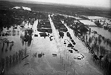 Areas in and around Augusta, Georgia, experienced damaging flooding
The
Savannah River
was subject to a record flood. An average of 8.84 in (225 mm) of rain fell across its watershed in 34 hours.
At
Augusta
, the river set a record
river stage
of 46.1 ft (14.1 m) on September 27.
[84]
At this point, the river flow rate was also a record 370,000 cu ft (10,000 m
3
) per second, 37 times greater than the river's flow rate at the onset of the rains.
While most of Augusta was protected by a levee, a 250 ft (76 m) break 3 mi (4.8 km) south of the city led to the inundation of several streets and 40 city blocks to a depth of around 2?4 ft (0.61?1.22 m).
[84]
In lower areas the flooding was up to 15 ft (4.6 m) deep.
The break occurred as the river was descending from its crest, lessening the potential damage; the flooding was relieved further by the opening of flood gates at Butlers Creek and a secondary levee breach nearby. Most homes in the flood zone were elevated and avoided significant damage.
With the onset of the second episode of floods towards the beginning of October, police and fire departments ordered the evacuation of residents in low-lying areas, fearing that the earlier floods had significantly weakened flood mitigation systems. A crew of conscripts and volunteers was assembled to fortify the levees, successfully repairing broken segments before the Savannah River's second crest.
Manufacturing and oil plants in low-lying areas north of Augusta were damaged by the floods. Much of the floodplain towards
South Carolina
was submerged by the swollen Savannah.
[84]
Farms suffered a total loss of crops and farm equipment. Numerous heads of cattle, hogs, and mules drowned.
The total cost of damage within a 50 mi (80 km) radius of Augusta was estimated at over $1 million,
[82]
with $275,000 in damage in the city proper. In
Columbia County
, located north of Augusta, agricultural losses exceeded $200,000.
Floods classified as "dangerous" by the Weather Bureau occurred along the
Altamaha
,
Ocmulgee
, and
Oconee
rivers; more moderate floods befell areas along the
Aplachicola
,
Chattahoochee
, and
Flint
rivers.
[82]
Total losses in the Altamaha River basin amounted to $500,000.
In the southwestern part of Georgia, damage from the storm was primarily wind-driven, and many pecans were blown from trees. A conservative estimate from the Weather Bureau appraised damage to agriculture, highways, and railroads at $3 million.
[82]
Flood damage in South Carolina from heavy rains on September 26?27 were exacerbated by additional rains associated with the hurricane on September 30 and October 1.
[88]
[89]
Heavy rains and strong winds swept across the
Piedmont
. The entire state recorded above-average rainfall for October due in part to the hurricane.
[89]
In
Hamburg
, which lies across the Savannah River opposite Augusta, Georgia, many homes were swept away by floodwaters. Eight dams were breached in the
Horse Creek Valley
. Damage in the
Santee River
watershed totaled $1.1 million, with most due to property damage; $160,000 in property damage was estimated to have been mitigated by timely flood warnings.
Total losses in South Carolina from flooding associated with the storm reached $3.829 million, of which $1.8 million was inflicted upon crops. Farming operations in South Carolina's northern and western counties were suspended across both uplands and lowlands.
[89]
The
Cape Fear River
in
North Carolina
experienced its third highest flood on record, leading to $800,000 in losses. However, further losses were avoided as crops were already partly harvested. Areas downstream were also afforded clear conditions during which crops and other stocks were moved to safety as the bulge of floodwaters flowed downstream.
October 1929 became the North Carolina's rainiest October on record upon its conclusion.
[90]
In
Virginia
, highways and bridges were damaged by flooded streams.
Southside
and
Southwest Virginia
were the parts of the state most heavily impacted.
[91]
High surf and damaging winds spread northward to the
Mid-Atlantic states
and
New England
,
causing heavy damage.
[80]
Trees were blown down in
The Berkshires
by strong winds enhanced by the local topography.
In
Maine
, heavy rains up to 1.88 inches (48 mm) flooded storm cellars and broke a prolonged dry spell in the state, though damage was minimal.
[92]
Canada
[
edit
]
The extratropical remnants of the hurricane exhibited winds of 40 mph (65 km/h) as they passed over
New Brunswick
and
Quebec
. Heavy rainfall and flooding were reported in New Brunswick and
Nova Scotia
. A peak rainfall total of 3.8 in (95 mm) was measured in
Saint John, New Brunswick
. Cellars and streets in the Saint John area had flood depths of 1 ft (0.30 m). Streets were flooded and damaged in
Digby
and
Truro, Nova Scotia
.
[93]
See also
[
edit
]
- 1926 Nassau hurricane
? passed directly over Nassau at a similar intensity
- Hurricane Betsy
? took a similar southwestward path through the Bahamas and Florida Keys
- Hurricane Dorian
? slow-moving Category 5 hurricane that caused catastrophic damage on Grand Bahama and Great Abaco islands
Notes
[
edit
]
- ^
HURDAT
, the official database for the intensities and tracks of Atlantic tropical cyclones maintained by the
National Hurricane Center
,
[1]
lists the
maximum sustained winds
of storms to the nearest five
knots
.
[2]
Conversions to miles per hour (mph) and kilometers per hours (km/h) based on this database are derived from the original value in knots and rounded to the nearest five.
- ^
All monetary values are in 1929
United States dollars
unless otherwise indicated.
References
[
edit
]
- Sources
- Barnes, Jay (May 2007). "Hurricanes in the Sunshine State, 1900?1949".
Florida's hurricane history
(2nd ed.). United States: The
University of North Carolina Press
. pp. 140?142.
ISBN
978-0-8078-5809-7
.
- Brooks, Charlie F. (October 1929).
"Sidelights on the Hurricane of September, 1929"
.
Bulletin of the American Meteorological Society
.
10
(10). Boston, Massachusetts: American Meteorological Society: 188?190.
Bibcode
:
1929BAMS...10..188.
.
doi
:
10.1175/1520-0477-10.10.188
.

- Hills, George B. (October 1929).
"The September 28, 1929, Tornado in Fort Lauderdale, Fla"
(PDF)
.
Monthly Weather Review
.
57
(10). National Oceanic and Atmospheric Administration: Silver Spring, Maryland: 420?421.
Bibcode
:
1929MWRv...57..420H
.
doi
:
10.1175/1520-0493(1929)57<420:TSTIFL>2.0.CO;2
. Retrieved
August 13,
2019
.
- Mitchell, Charles L. (October 1929a).
"The Tropical Cyclone of September 18?October 4, 1929"
(PDF)
.
Monthly Weather Review
.
57
(10). Silver Spring, Maryland: National Oceanic and Atmospheric Administration: 418?420.
Bibcode
:
1929MWRv...57..418M
.
doi
:
10.1175/1520-0493(1929)57<418:TTCOSO>2.0.CO;2
. Retrieved
August 13,
2019
.
- Spencer, R. E. (October 1929).
"Rivers and Floods"
(PDF)
.
Monthly Weather Review
.
57
(10). Washington, D.C.: United States Weather Bureau: 435?437.
Bibcode
:
1929MWRv...57..435S
.
doi
:
10.1175/1520-0493(1929)57<435b:RAF>2.0.CO;2
. Retrieved
March 29,
2020
– via National Oceanic and Atmospheric Administration.
- Neely, Wayne (2011).
The Great Bahamas Hurricane of 1929
. Bloomington, Indiana: iUniverse LLC.
ISBN
9781491716137
.
- Rosenberg, Pierce S. (1970).
The Great Andros Hurricane
(PDF)
(Report). Miami, Florida: Atlantic Oceanographic and Meteorological Laboratory
. Retrieved
August 13,
2019
.
- Citations
- ^
Landsea, Chris; Franklin, James; Beven, Jack (May 2015).
"The revised Atlantic hurricane database (HURDAT2)"
(PDF)
. Miami, Florida: National Hurricane Center
. Retrieved
April 1,
2020
.
- ^
"Original HURDAT Format"
.
Atlantic Oceanographic and Meteorological Laboratory
. Miami, Florida: National Oceanic and Atmospheric Administration
. Retrieved
April 1,
2020
.
- ^
"Assessment of the Effects and Impacts of Hurricane Dorian in the Bahamas"
(PDF)
. Inter-American Development Bank. November 15, 2019. p. 1
. Retrieved
March 30,
2020
.
- ^
a
b
c
d
e
f
g
h
i
j
k
l
m
n
o
p
q
r
s
t
u
v
w
x
y
z
aa
ab
ac
ad
ae
af
ag
ah
ai
aj
ak
al
Neely, Wayne (2019). "The Great Bahamas Hurricane of 1929 or the Great Andros Island Hurricane of 1929's Impact on the Islands of The Bahamas".
The Greatest and Deadliest Hurricanes to Impact the Bahamas: The Stories Behind the Great Storms
. Bloomington, Indiana: iUniverse LLC.
ISBN
978-1532089237
.
OCLC
1132243360
.
- ^
a
b
c
d
e
f
g
h
i
j
k
l
m
n
Landsea, Chris
; Anderson, Craig; Bredemeyer, William; Carrasco, Cristina; Charles, Noel; Chenoweth, Michael; Clark, Gil; Delgado, Sandy; Dunion, Jason; Ellis, Ryan; Fernandez-Partagas, Jose; Feuer, Steve; Gamanche, John; Glenn, David; Hagen, Andrew; Hufstetler, Lyle; Mock, Cary; Neumann, Charlie; Perez Suarez, Ramon; Prieto, Ricardo; Sanchez-Sesma, Jorge; Santiago, Adrian; Sims, Jamese; Thomas, Donna; Lenworth, Woolcock; Zimmer, Mark (May 2015).
"Documentation of Atlantic Tropical Cyclones Changes in HURDAT"
.
Atlantic Oceanographic and Meteorological Laboratory
(Metadata).
Miami, Florida
: National Oceanic and Atmospheric Administration. 1929/02 - 2010 Revision
. Retrieved
August 13,
2019
.
- ^
a
b
c
d
"Atlantic hurricane best track (HURDAT version 2)"
(Database). United States
National Hurricane Center
. April 5, 2023
. Retrieved
June 15,
2024
.
 This article incorporates text from this source, which is in the
public domain
.
This article incorporates text from this source, which is in the
public domain
.
- ^
"Death Looms for Steamer's Crew"
.
The Palm Beach Post
. Vol. 21, no. 228. West Palm Beach, Florida. Associated Press. September 26, 1929. p. 1
. Retrieved
March 30,
2020
– via Newspapers.com.
- ^
a
b
"Hurricane Sweeps Out of Bahamas Toward Florida"
.
The Atlanta Constitution
. Vol. 62, no. 102. Atlanta, Georgia. Associated Press. September 25, 1929. p. 1
. Retrieved
March 30,
2020
– via Newspapers.com.
- ^
a
b
c
"3-Day Storm Leaves 20 Dead in Bahama City"
.
The Palm Beach Post
. Vol. 21, no. 230. West Palm Beach, Florida. Associated Press. September 28, 1929. p. 1
. Retrieved
April 3,
2020
– via Newspapers.com.
- ^
"Historical Sites"
.
Places of Interest
. Nassau, The Bahamas: The Government of The Bahamas. 2011
. Retrieved
April 1,
2020
.
- ^
Webbe, Stephen (July 24, 1980).
"Bounty from the Bahamian seas; Return of the sponge"
.
Christian Science Monitor
. The Christian Science Monitor
. Retrieved
April 2,
2020
.
- ^
"Storm Presents Phenomena Never Before Recorded"
.
The Palm Beach Post
. Vol. 21, no. 228. West Palm Beach, Florida. Associated Press. September 26, 1929. p. 1
. Retrieved
March 30,
2020
– via Newspapers.com.
- ^
a
b
"Storm Slow in March to East Coast"
.
The Miami Herald
. Vol. 19, no. 300. Miami, Florida. September 26, 1929. p. 13
. Retrieved
April 1,
2020
– via Newspapers.com.
- ^
a
b
c
"Center of Storm Expected to Hit Close to Miami"
.
The Palm Beach Post
. Vol. 21, no. 228. West Palm Beach, Florida. Associated Press. September 26, 1929. pp. 1?2
. Retrieved
March 30,
2020
– via Newspapers.com.
- ^
"State Health Board Ready for Emergency"
.
Tampa Morning Tribune
. No. 269. Tampa, Florida. Associated Press. September 26, 1929. p. 2
. Retrieved
April 1,
2020
– via Newspapers.com.
- ^
"Police, National Guard Are Ordered for Duty"
.
The Palm Beach Post
. Vol. 21, no. 228. West Palm Beach, Florida. September 26, 1929. p. 3
. Retrieved
March 31,
2020
– via Newspapers.com.
- ^
"Evacuation of Glades Aided by Railroads"
.
The Miami Herald
. Vol. 19, no. 300. Miami, Florida. September 26, 1929. p. 13
. Retrieved
April 1,
2020
– via Newspapers.com.
- ^
a
b
c
d
"City Ready for Tropical Blow"
.
The Palm Beach Post
. Vol. 21, no. 228. West Palm Beach, Florida. September 26, 1929. p. 1
. Retrieved
March 30,
2020
– via Newspapers.com.
- ^
"Pan-American Sends Airplanes to Havana"
.
The Miami Herald
. Vol. 19, no. 300. Miami, Florida. September 26, 1929. p. 13
. Retrieved
April 1,
2020
– via Newspapers.com.
- ^
"Partial Evacuation of Glades is Made: Hundreds Come Here"
.
The Palm Beach Post
. Vol. 21, no. 228. West Palm Beach, Florida. September 26, 1929. p. 1
. Retrieved
March 30,
2020
– via Newspapers.com.
- ^
"Everglades Exodus Started from Lake"
.
The Palm Beach Post
. Vol. 21, no. 228. West Palm Beach, Florida. September 26, 1929. p. 2
. Retrieved
March 30,
2020
– via Newspapers.com.
- ^
"Residents Pouring Out of Glades as Storm Approaches"
.
Tampa Morning Tribune
. No. 269. Tampa, Florida. Associated Press. September 26, 1929. p. 2
. Retrieved
April 1,
2020
– via Newspapers.com.
- ^
"Heaving Traffic Heading North"
.
The Palm Beach Post
. Vol. 21, no. 228. West Palm Beach, Florida. September 26, 1929. p. 2
. Retrieved
March 31,
2020
– via Newspapers.com.
- ^
"Lauderdale Glass Steady at 29.75"
.
The Palm Beach Post
. Vol. 21, no. 228. West Palm Beach, Florida. September 26, 1929. p. 1
. Retrieved
March 30,
2020
– via Newspapers.com.
- ^
"Red Cross Names Bodies for Duty"
.
The Palm Beach Post
. Vol. 21, no. 228. West Palm Beach, Florida. September 26, 1929. p. 1
. Retrieved
March 31,
2020
– via Newspapers.com.
- ^
"Light Company Ready With Steaming Plant"
.
The Palm Beach Post
. Vol. 21, no. 228. West Palm Beach, Florida. September 26, 1929. p. 1
. Retrieved
March 30,
2020
– via Newspapers.com.
- ^
"American Legion to Help Red Cross"
.
The Palm Beach Post
. Vol. 21, no. 228. West Palm Beach, Florida. September 26, 1929. p. 1
. Retrieved
March 30,
2020
– via Newspapers.com.
- ^
"Red Cross Disaster Relief Group Meets"
.
The Miami Herald
. Vol. 19, no. 300. Miami, Florida. September 26, 1929. p. 4
. Retrieved
April 1,
2020
– via Newspapers.com.
- ^
"Lake Worth Unit Prepares for Duty"
.
The Palm Beach Post
. Vol. 21, no. 228. West Palm Beach, Florida. September 26, 1929. p. 2
. Retrieved
March 30,
2020
– via Newspapers.com.
- ^
"Jupiter Organization Perfected for Aid"
.
The Palm Beach Post
. Vol. 21, no. 228. West Palm Beach, Florida. September 26, 1929. p. 2
. Retrieved
March 30,
2020
– via Newspapers.com.
- ^
"Directions Given by Red Cross for Handling Casualties"
.
The Palm Beach Post
. Vol. 21, no. 228. West Palm Beach, Florida. September 26, 1929. p. 3
. Retrieved
March 30,
2020
– via Newspapers.com.
- ^
a
b
"U.S. Bureau Hopeful Storm Will Not Hit Southeast Florida"
.
Fort Lauderdale Daily News
. Vol. 18, no. 309. Fort Lauderdale, Florida. Associated Press. September 27, 1929. p. 1
. Retrieved
April 2,
2020
– via Newspapers.com.
- ^
"Hollywood Back to Normal Today"
.
Fort Lauderdale Daily News
. Vol. 18, no. 309. Fort Lauderdale, Florida. September 27, 1929. p. 1
. Retrieved
April 2,
2020
– via Newspapers.com.
- ^
"Lauderdale Smiles as Storm Recedes"
.
Fort Lauderdale Daily News
. Vol. 18, no. 309. Fort Lauderdale, Florida. September 27, 1929. p. 1
. Retrieved
April 2,
2020
– via Newspapers.com.
- ^
"Boat is Sent to Key West"
.
St. Petersburg Times
. Vol. 47, no. 113. St. Petersburg, Florida. September 27, 1929. p. 10
. Retrieved
April 2,
2020
– via Newspapers.com.
- ^
"Island Residents Warned of Storms"
.
The Palm Beach Post
. Vol. 21, no. 230. West Palm Beach, Florida. Associated Press. September 28, 1929. p. 1
. Retrieved
April 3,
2020
– via Newspapers.com.
- ^
"Storm Nears Coast of North Florida; Pensacola in Path"
.
The Tampa Daily Times
. Tampa, Florida. Associated Press. September 30, 1929. p. 1
. Retrieved
April 3,
2020
.
- ^
"Water Recedes in Homestead; Loss Enormous"
.
Fort Lauderdale Daily News
. Vol. 18, no. 311. Fort Lauderdale, Florida. September 30, 1929. p. 1
. Retrieved
April 3,
2020
.
- ^
a
b
Swanson, Gail; Wilkinson, Jerry (October 6, 2013).
"Florida Keys Hurricanes of the Last Millennium"
.
Keys Historeum
. Key Largo, Florida: Historical Preservation Society of the Upper Keys
. Retrieved
August 15,
2019
.
- ^
"3-Day Storm Leaves 20 Dead in Bahama City"
.
The Palm Beach Post
. Vol. 21, no. 230. West Palm Beach, Florida. Associated Press. September 28, 1929. p. 1
. Retrieved
April 3,
2020
– via Newspapers.com.
- ^
a
b
Mitchell, Alexander J. (September 1929b).
"Florida Section"
(PDF)
.
Climatological Data
.
33
(9). Jacksonville, Florida: United States Weather Bureau: 33. Archived from
the original
(PDF)
on March 29, 2020
. Retrieved
March 29,
2020
– via National Centers for Environmental Information.
- ^
"16 Persons Hurt At Ft. Lauderdale by Cyclonic Blow"
.
The Palm Beach Post
. Vol. 21, no. 231. West Palm Beach, Florida. Associated Press. p. 1
. Retrieved
April 3,
2020
– via Newspapers.com.
- ^
Smyth, Patrick H. (September 1929).
"Florida Section"
(PDF)
.
Climatological Data
.
35
(9). Montgomery, Alabama: United States Weather Bureau: 34. Archived from
the original
(PDF)
on March 29, 2020
. Retrieved
March 29,
2020
– via National Centers for Environmental Information.
- ^
a
b
"Severe Local Storms, October, 1929"
(PDF)
.
Monthly Weather Review
.
57
(10). Washington, D.C.: United States Weather Bureau: 435. October 1929.
Bibcode
:
1929MWRv...57..435.
.
doi
:
10.1175/1520-0493(1929)57<435a:SLSO>2.0.CO;2
– via American Meteorological Society.
- ^
Schoner, R. W.; Molansky, S. (July 1956). "Storm of September 23?28, 1929".
Rainfall Associated With Hurricanes (And Other Tropical Disturbances)
(PDF)
. Washington, D.C.: National Hurricane Research Project. p. 114.
OCLC
1015746192
. Retrieved
March 29,
2020
– via National Oceanic and Atmospheric Administration.
- ^
a
b
c
d
von Herrmann, C. F. (October 1929).
"Georgia Section"
(PDF)
.
Climatological Data
.
33
(10). Atlanta, Georgia: United States Weather Bureau: 33. Archived from
the original
(PDF)
on March 29, 2020
. Retrieved
March 29,
2020
– via National Centers for Environmental Information.
- ^
a
b
c
d
von Herrmann, C. F. (September 1929).
"Georgia Section"
(PDF)
.
Climatological Data
.
33
(9). Atlanta, Georgia: United States Weather Bureau: 33. Archived from
the original
(PDF)
on March 29, 2020
. Retrieved
March 29,
2020
– via National Centers for Environmental Information.
- ^
Sullivan, Richard H. (September 1929).
"South Carolina Section"
(PDF)
.
Climatological Data
.
32
(9). Columbia, South Carolina: United States Weather Bureau: 33. Archived from
the original
(PDF)
on March 29, 2020
. Retrieved
March 29,
2020
.
- ^
a
b
c
Sullivan, Richard H. (October 1929).
"South Carolina Section"
(PDF)
.
Climatological Data
.
32
(10). Columbia, South Carolina: United States Weather Bureau: 37. Archived from
the original
(PDF)
on March 29, 2020
. Retrieved
March 29,
2020
.
- ^
Denson, Lee A. (October 1929).
"North Carolina Section"
(PDF)
.
Climatological Data
.
34
(10). Montgomery, Alabama: United States Weather Bureau: 37. Archived from
the original
(PDF)
on March 29, 2020
. Retrieved
March 29,
2020
– via National Centers for Environmental Information.
- ^
"State Roads Are Damaged by Long Rain"
.
The Staunton News-Leader
. No. 236. Staunton, Virginia. October 3, 1929. p. 1
. Retrieved
April 3,
2020
– via Newspapers.com.
- ^
Cotterly, Wayne (1996).
Hurricanes & Tropical Storms: The Impact on Maine and Androscoggin County
(PDF)
(Report). p. 29. Archived from
the original
(PDF)
on April 1, 2016
. Retrieved
October 9,
2009
.
- ^
"1929-2"
.
A Climatology of Hurricanes for Eastern Canada
. Ottawa, Canada:
Environment and Climate Change Canada
. November 19, 2009. Archived from
the original
on November 18, 2017
. Retrieved
April 1,
2020
.
External links
[
edit
]