| 1895 Atlantic hurricane season
|
|---|
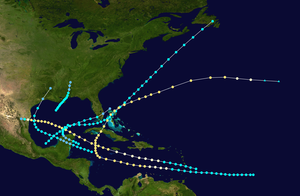 Season summary map
|
|
| First system formed
| August 14, 1895
|
|---|
| Last system dissipated
| October 26, 1895
|
|---|
|
|
| Name
| Two
|
|---|
| ? Maximum winds
| 110 mph (175 km/h)
(
1-minute sustained
)
|
|---|
| ? Lowest pressure
| 963
mbar
(
hPa
; 28.44
inHg
)
|
|---|
|
|
|
| Total storms
| 6
|
|---|
| Hurricanes
| 2
|
|---|
| Total fatalities
| 56
|
|---|
| Total damage
| > $1 million (1895
USD
)
|
|---|
|
|
|
Atlantic hurricane seasons
1893
,
1894
,
1895
,
1896
,
1897
|
The
1895 Atlantic hurricane season
was a fairly inactive one, featuring only six known
tropical cyclones
, although each of them made
landfall
. Of those six systems, only two intensified a hurricane, while none of those strengthened into a major hurricane.
[nb 1]
However, in the absence of modern satellite and other remote-sensing technologies, only storms that affected populated land areas or encountered ships at sea were recorded, so the actual total could be higher. An undercount bias of zero to six tropical cyclones per year between 1851 and 1885 and zero to four per year between 1886 and 1910 has been estimated.
[2]
During their respective reassessments of the season, neither meteorologists Jose Fernandez-Partagas and Henry F. Diaz in 1996 nor the
Atlantic hurricane reanalysis project
added or removed any storms from
official hurricane database
(HURDAT). However, the latter retroactively downgraded the fifth system from a major hurricane to a Category 2 storm on the present-day
Saffir?Simpson scale
. A reanalysis study by climate researcher Michael Chenoweth, published in 2014, concluded that 10 tropical cyclones
formed in the Atlantic
in 1895, suggesting the removal of two storms from HURDAT and the addition to six storms. However, the changes suggested in Chenoweth's study have yet to be included in HURDAT.
On August 14, ships detected the season's first known cyclone over the
Gulf of Mexico
. The storm struck
Louisiana
and
Mississippi
, producing rains and winds along the
Gulf Coast of the United States
and in
Georgia
. Later that month, the second storm caused at least $1 million (1895
USD
) in damage in northeastern
Mexico
alone.
[nb 2]
The track for the season's third system begins on September 28 over the northwestern
Caribbean Sea
. Although it crossed the
Yucatan Peninsula
and the
Bahamas
after moving near the
Florida Keys
, the cyclone most severely impacted Cuba, where 56 deaths occurred. In mid-October, the fifth storm of the season also impacted Cuba,
Florida
, and the Bahamas, as well as
Bermuda
, with an unknown number of people killed in Cuba. The storm likely became
extratropical
on October 26 to the southwest of the
Azores
.
Season summary
[
edit
]
The Atlantic hurricane database (HURDAT) officially recognizes that six tropical cyclones formed during the 1895 season, two of which strengthened into a hurricane, with none of those intensifying into a major hurricane.
[1]
The
Atlantic hurricane reanalysis project
did not add or remove any storms from the 1996 reanalysis of the season by meteorologists Jose Fernandez-Partagas and Henry F. Diaz, although the former downgraded the fifth storm from major hurricane status.
[3]
However, a more recent reanalysis by climate researcher Michael Chenoweth, published in 2014, adds six storms and removes two ? the fourth and sixth systems ? for a net gain of four cyclones, although these proposed changes have yet to be approved for inclusion to HURDAT. Chenoweth's study utilizes a more extensive collection of newspapers and ship logs, as well as late 19th century weather maps for the first time, in comparison to previous reanalysis projects.
[4]
Chenoweth's proposals have yet to be incorporated into HURDAT, however.
[5]
Ships detected the season's first known cyclone on August 14 over the Gulf of Mexico. Striking
Louisiana
and
Mississippi
, the storm dissipated on August 17. Later in August, the second cyclone traversed the Caribbean before striking the
Yucatan Peninsula
on August 27 as a hurricane and then making another landfall in Mexico in
Tamaulipas
on August 30. On September 28, the track for the season's third system begins in the northwestern Caribbean Sea. Remaining a tropical storm, the cyclone struck the Yucatan Peninsula,
the Bahamas
, and
Newfoundland
before dissipating on October 7. The final three known tropical cyclones developed in October, with the first and third of those storms remaining minimal tropical storms. However, the second October storm – the fifth Atlantic cyclone of the year – struck
Cuba
and the Bahamas and moved near or over
Bermuda
at hurricane intensity until transitioning into an
extratropical cyclone
on October 26, concluding seasonal activity.
[5]
The season's activity was reflected with an
accumulated cyclone energy
(ACE) rating of 69, the third lowest total of the decade. ACE is a metric used to express the energy used by a tropical cyclone during its lifetime. Therefore, a storm with a longer duration will have higher values of ACE. It is only calculated at six-hour increments in which specific tropical and subtropical systems are either at or above sustained wind speeds of 39 mph (63 km/h), which is the threshold for tropical storm intensity. Thus, tropical depressions are not included here.
[1]
Systems
[
edit
]
Tropical Storm One
[
edit
]
|
|
| Duration
| August 14 ? August 17
|
|---|
| Peak intensity
| 60 mph (95 km/h)
(1-min)
;
≤1009
mbar
(
hPa
)
|
|---|
Ships detected a tropical storm over the north-central
Gulf of Mexico
on August 14.
[6]
Peaking with sustained winds of 60 mph (95 km/h), the cyclone struck
Buras, Louisiana
, at 19:00 UTC the following day. The storm then re-emerged into the Gulf of Mexico and made landfall in
Mississippi
on
Horn Island
around 13:00 UTC on August 16 and then the mainland between
Ocean Springs
and
Pascagoula
. After moving inland, the system weakened to a tropical depression and dissipated over
Alabama
on August 17.
[5]
Climate researcher Michael Chenoweth proposed shifting the track slightly farther west in a 2014 reanalysis study but suggested few other changes.
[4]
As a result of the storm,
New Orleans, Louisiana
, recorded sustained winds of 30 mph (48 km/h), while
Pensacola, Florida
, observed sustained winds reaching 48 mph (77 km/h).
[6]
A weather station in Louisiana recorded 4.2 in (110 mm) of rainfall in 24 hours, while about 2 to 4 in (51 to 102 mm) of precipitation fell from there into
Georgia
, causing damage to cotton crops.
[7]
Hurricane Two
[
edit
]
|
|
| Duration
| August 22 ? August 30
|
|---|
| Peak intensity
| 110 mph (175 km/h)
(1-min)
;
963
mbar
(
hPa
)
|
|---|
Colegio de Belen
meteorological observatory director Father Lorenzo Gangioti reported a tropical storm west of
Dominica
on August 22.
[6]
Thus, the official track for this cyclone begins several hours earlier, when it was situated just east of
Barbados
. The storm moved west-northwestward into the Caribbean and strengthened into a hurricane by August 23. While passing near the south coast of
Jamaica
two days later, the system intensified into a Category 2 on the present-day
Saffir?Simpson scale
. The official track brings the storm ashore near the northeastern tip of the
Yucatan Peninsula
around 00:00 UTC on August 27, though the hurricane soon entered the Gulf of Mexico.
[5]
Thereafter, the cyclone likely intensified further in the Gulf of Mexico and peaked with winds of 110 mph (175 km/h) and a minimum barometric pressure of 963 mbar (28.4 inHg), both estimated based on damage in Mexico.
[3]
[8]
Early on August 30, the hurricane made landfall near
Laguna Madre
,
Tamaulipas
, and then quickly weakened, dissipating within several hours of moving inland.
[5]
Chenoweth extended the track back a day earlier, initiating the track at tropical depression status on August 21. His study, published in 2014, also concludes that the storm reached major hurricane intensity on August 28 over the Gulf of Mexico.
[4]
Winds generated by the storm in western Cuba downed some poles in
Pinar del Rio Province
.
[6]
The hurricane reportedly washed away the town of Abasola and destroyed all homes in Rodriguez in northeastern Mexico.
[9]
Damage to property reached into the millions of dollars. The
Mexican National
and the
Monterey and Gulf
railways reportedly suffered the heaviest losses,
[10]
with several hundred yards of the former completely washout in some places and many destroyed rail bridges. The Mexican National Telegraph company lost approximately 5 mi (10 km) of wires and the government telegraph wires suffered similarly, leaving communications with Mexico only intact via
Mexico City
to
Eagle Pass, Texas
.
[11]
Hurricane force-wind gusts were reported in Texas as far north as
Corpus Christi
, while tropical storm-force wind gusts reached
Velasco
. The former experienced a number of down trees and demolished homes. Additionally,
Rockport
reported its highest tide since 1883, while coastal flooding inundated several streets in
Galveston
.
[9]
Tropical Storm Three
[
edit
]
|
|
| Duration
| September 28 ? October 7
|
|---|
| Peak intensity
| 60 mph (95 km/h)
(1-min)
;
≤989
mbar
(
hPa
)
|
|---|
Meteorologist
Ivan Ray Tannehill
began the track for this storm in the northwest Caribbean on September 28 during his 1938 review of the season, which subsequent meteorologists such as Jose Fernandez Partagas and Henry F. Diaz confirmed in their 1995 reanalysis.
[6]
The system moved west-northwestward and made landfall in the
Yucatan Peninsula
south of
Tulum
.
[5]
Due to trekking across the peninsula for several hours, the cyclone likely weakened to a tropical depression, but re-intensified into a tropical storm upon emerging into the Gulf of Mexico on September 29. Thereafter, the storm peaked with winds of 60 mph (95 km/h) as it curved northeastward and then almost due eastward by the following day. However, upon reaching the
Straits of Florida
late on October 1, the cyclone assumed a east-northeastward to northeastward motion while passing just south of the
Florida Keys
. By October 3, the storm moved northeastward towards the western Bahamas, crossing the
Abaco Islands
before reaching the open Atlantic. The cyclone moved ashore
Newfoundland
near the
Burin Peninsula
on October 7 and was last noted shortly thereafter.
[5]
Heavy rains fell over western Cuba, causing floods that led to significant crop losses and the destruction of some dwellings in
Pinar del Rio
and
La Habana
provinces.
[6]
Additionally, a railroad company suffered about $300,000 in losses.
[12]
This storm was responsible for an estimated 56 deaths in Cuba.
[13]
General Martinez de Campos requested that the government provide aid to people residing in the
Vuelta Abajo
region.
[12]
Although the cyclone moved just south of the Florida Keys,
Key West
only recorded sustained winds of 20 mph (32 km/h), while
Titusville
observed sustained winds of 40 mph (65 km/h). Heavy rains fell in
Jupiter
,
[14]
where a downed wire cutoff communications with the telegraph station.
[15]
The schooner
Albertine
lost its mast during the storm over the
Grand Banks of Newfoundland
on October 7.
[6]
The 2014 study by Chenoweth concluded that this storm formed over the southwestern Caribbean on September 25. Moving northwestward, the cyclone strikes
Nicaragua
and then curves north-northwestward before making landfall on the Yucatan Peninsula. Chenoweth then proposed a more southerly path, bringing the storm across Cuba rather than near the Florida Keys.
[4]
Tropical Storm Four
[
edit
]
|
|
| Duration
| October 2 ? October 7
|
|---|
| Peak intensity
| 40 mph (65 km/h)
(1-min)
;
|
|---|
The track for this system begins over the northwestern Caribbean on October 2, despite Fernandez Partagas and Diaz expressing skepticism about the cyclone's early stages due to the proximity of the previous storm.
[6]
Moving west-northwestward, the storm struck the Yucatan Peninsula on October 4 and quickly weakened to a tropical depression. After emerging into the Gulf of Mexico early on October 5, the storm quickly re-strengthened into a tropical storm. By October 6, the cyclone turned northeastward, making landfall in
Galveston, Texas
, early the next day. After moving inland, the system rapidly weakened, dissipating over northern Louisiana on October 7.
[5]
Due to no reports of gale-force winds, including Louisiana and Texas only recording sustained winds of 29?35 mph (47?56 km/h), the Atlantic hurricane reanalysis project concluded that the cyclone was, at most, a minimal tropical storm.
[3]
Chenoweth proposed the removal of this storm from HURDAT, finding "No evidence in land-based reports or from ships".
[4]
Hurricane Five
[
edit
]
|
|
| Duration
| October 12 ? October 26
|
|---|
| Peak intensity
| 105 mph (165 km/h)
(1-min)
;
≤973
mbar
(
hPa
)
|
|---|
The official track for this begins about 1,000 mi (1,610 km) east of
Barbados
on October 12. Moving westward to west-northwestward, the system passed through the
Windward Islands
three days later. After entering the Caribbean, the storm intensified into a hurricane on October 16 and to Category 2 hurricane about 24 hours later, peaking with winds of 105 mph (165 km/h). The hurricane turned northward on October 19, passing just west of the
Cayman Islands
on the next day. Thereafter, the cyclone curved north-northeastward and made landfall in Cuba near the city of
Cienfuegos
around 18:00 UTC on October 21. Quickly emerging into the southwestern Atlantic early the next day, the storm struck
Grand Bahama
island in the Bahamas shortly after 12:00 UTC. A more northeasterly motion then commenced and the hurricane crossed over or near
Bermuda
on October 24. The system likely began weakening significantly on the following day and transitioned into an extratropical cyclone about 700 mi (1,125 km) southwest of
Flores Island
in the
Azores
on October 26. The extratropical remnants dissipated several hours thereafter.
[5]
In Cuba, strong winds produced by the storm left significant impacts in
Santa Clara Province
. This included the destruction of buildings throughout the province, while many other structures lost their roof. Additionally, winds uprooted a number of large trees and downed sugar mill chimneys. Farther west, several towns reported severe flooding, such as in
Aguacate
,
Ceiba del Agua
,
Guines
,
Madruga
,
Nueva Paz
, and
San Nicolas
.
[6]
Some lives were reportedly lost in Cuba.
[16]
Parts of the east coast of Florida observed tropical storm-force wind gusts, reaching 55 mph (89 km/h) at both
Jupiter
and
Key West
.
[6]
The storm washed away nearly all wharves from
Juno
to
Lantana
. Heavy rainfall left some washouts at nearby sections of the
Florida East Coast Railway
.
[17]
In the Bahamas, the storm caused extensive damage on some islands. A correspondent to
The Nassau Guardian
described northern
Bimini
as "a wreck from one end to the other." Fewer than half a dozen homes on the island escaped damage, while approximately 2,000 coconut palm trees were uprooted.
[18]
Strong winds on Bermuda toppled large trees across the island and snapped about 30 telephone poles in
Devonshire Parish
.
[6]
Some homes were deroofed and several
verandas
collapsed.
[19]
A reanalysis study by Chenoweth, published in 2014, initiates the track for this storm over the southwest Caribbean on October 17. By October 20, the cyclone then follows a similar path to that in HURDAT, albeit slightly farther west, with a landfall on Cuba's
Zapata Peninsula
.
[4]
Tropical Storm Six
[
edit
]
|
|
| Duration
| October 13 ? October 17
|
|---|
| Peak intensity
| 40 mph (65 km/h)
(1-min)
;
|
|---|
According to Weather Bureau meteorologist Charles L. Mitchell in 1924, this storm was first observed over the Bay of Campeche on October 13.
[6]
Moving generally northwestward to west-northwestward across the Gulf of Mexico, the cyclone struck just south of
Everglades City, Florida
, on October 16. The storm quickly weakened to a tropical depression before it emerged into the Atlantic near present-day
Delray Beach
later that day. Early on October 17, the depression dissipated just north of
Grand Bahama
island in the Bahamas.
[5]
Chenoweth argued for the removal of this system from HURDAT, finding "No evidence in land-based reports or from ships".
[4]
Other storms
[
edit
]
While HURDAT currently recognizes six tropical cyclones for the 1895 season,
[5]
Chenoweth proposed a total of ten systems in his reanalysis study, published in 2014. This included the removal of two systems and the addition of six storms others not listed in HURDAT. The first unofficial system began on June 8 as a
subtropical storm
offshore
North Carolina
. Early the next day, the subtropical system became fully tropical. On June 11, the cyclone made landfall in North Carolina and then dissipated the following day. Later in June, another storm also formed offshore the Carolinas on June 17. The storm moved generally northeastward to north-northeastward, aside from a jog to the southeast for a few days, before becoming extratropical by June 21.
[4]
On September 1, the next unofficial storm developed east of the Lesser Antilles. After moving northwestward and then northward, the cyclone turned northeastward by September 5 and transitioned into an extratropical system north of the Azores two days later. Another storm proposed by Chenoweth formed on September 11 and moved erratically to the north of the Azores before becoming extratropical after lasting for about a week. Later that month, a cyclone developed on September 28 near the
Cabo Verde Islands
. After initially moving west-northwestward, the storm turned west-southwestward before dissipating on October 1. Chenoweth's final proposed cyclone developed as a subtropical storm on November 3 northwest of the Cabo Verde Islands. Moving northwestward, the system became a tropical storm by the following day. The storm then turned northeastward on November 6, moving in that direction before transitioning into an extratropical cyclone on November 7.
[4]
Season effects
[
edit
]
This is a table of all of the known storms that have formed in the 1895 Atlantic hurricane season. It includes their duration, landfall, damages, and death totals. Deaths in parentheses are additional and indirect (an example of an indirect death would be a traffic accident), but were still related to that storm. Damage and deaths include totals while the storm was extratropical, a wave, or a low, and all of the damage figures are in 1895 USD.
1895
North Atlantic tropical cyclone
season statistics
Storm
name
|
Dates active
|
Storm
category
at peak intensity
|
Max 1-min
wind
mph (km/h)
|
Min.
press.
(
mbar
)
|
Areas affected
|
Damage
(
USD
)
|
Deaths
|
Ref(s)
|
| One
|
August 14?17
|
Tropical storm
|
60 (95)
|
1009
|
Gulf Coast of the United States, Georgia
|
Unknown
|
None
|
|
| Two
|
August 22?30
|
Category 2 hurricane
|
110 (175)
|
963
|
Lesser Antilles, Cuba, Mexico, Texas
|
>$1 million
|
None
|
[10]
|
| Three
|
September 28 ? October 7
|
Tropical storm
|
60 (95)
|
989
|
Mexico, Cuba, Florida, Bahamas
|
>$300,000
|
56
|
[12]
[13]
|
| Four
|
October 2?7
|
Tropical storm
|
40 (65)
|
Unknown
|
Mexico, Gulf Coast of the United States
|
Unknown
|
None
|
|
| Five
|
October 12?26
|
Category 2 hurricane
|
105 (165)
|
973
|
Cuba, Florida, Bahamas, Bermuda
|
Unknown
|
Unknown
|
|
| Six
|
October 13?17
|
Tropical storm
|
40 (65)
|
Unknown
|
Florida
|
Unknown
|
None
|
|
| Season aggregates
|
| 6 systems
|
August 2 ? October 26
|
|
145 (230)
|
938
|
|
>$1.3 million
|
>56
|
|
See also
[
edit
]
Notes
[
edit
]
References
[
edit
]
- ^
a
b
c
North Atlantic Hurricane Basin (1851-2022) Comparison of Original and Revised HURDAT
.
Hurricane Research Division
;
Atlantic Oceanographic and Meteorological Laboratory
(Report). Miami, Florida:
National Oceanic and Atmospheric Administration
. April 2023
. Retrieved
March 17,
2024
.
- ^
Landsea, Christopher W. (2004). "The Atlantic hurricane database re-analysis project: Documentation for the 1851?1910 alterations and additions to the HURDAT database". In Murname, Richard J.; Liu, Kam-biu (eds.).
Hurricanes and Typhoons: Past, Present and Future
. New York City, New York: Columbia University Press. p. 195.
ISBN
0-231-12388-4
. Retrieved
March 16,
2024
.
- ^
a
b
c
Landsea, Christopher W.; et al. (May 2015).
Documentation of Atlantic Tropical Cyclones Changes in HURDAT
.
Hurricane Research Division
(Report). National Hurricane Center
. Retrieved
April 30,
2024
.
- ^
a
b
c
d
e
f
g
h
i
Chenoweth, Michael (December 2014).
"A New Compilation of North Atlantic Tropical Cyclones, 1851?98"
.
Journal of Climate
.
27
(12).
American Meteorological Society
.
Bibcode
:
2014JCli...27.8674C
.
doi
:
10.1175/JCLI-D-13-00771.1
. Retrieved
April 29,
2024
.
- ^
a
b
c
d
e
f
g
h
i
j
k
"Atlantic hurricane best track (HURDAT version 2)"
(Database). United States
National Hurricane Center
. April 5, 2023
. Retrieved
June 15,
2024
.
 This article incorporates text from this source, which is in the
public domain
.
This article incorporates text from this source, which is in the
public domain
.
- ^
a
b
c
d
e
f
g
h
i
j
k
l
Fernandez-Partagas, Jose; Diaz, Henry F. (1996).
"A Reconstruction of Historical Tropical Cyclone Frequency in the Atlantic from Documentary and other Historical Sources: Year 1895"
(PDF)
. National Oceanic and Atmospheric Administration
. Retrieved
December 6,
2023
.
- ^
"Will Barely Miss Us"
.
The Daily Advertiser
. Montgomery, Alabama. August 17, 1895. p. 7
. Retrieved
December 6,
2023
– via Newspapers.com.

- ^
"Continental United States Hurricane Impacts/Landfalls 1851-2022"
.
Atlantic Oceanographic and Meteorological Laboratory's Hurricane Research Division
. National Oceanic and Atmospheric Administration. April 2023
. Retrieved
May 20,
2024
.
- ^
a
b
Roth, David (January 6, 2010).
Texas Hurricane History
(PDF)
(Report). Silver Spring, Maryland: National Weather Service. pp. 25?26
. Retrieved
December 6,
2023
.
- ^
a
b
"Foreign Intelligence"
.
The Seneca News
. Seneca, Illinois. September 7, 1895. p. 2
. Retrieved
December 6,
2023
– via Newspapers.com.
- ^
"Mexico's Fiercest Storm"
.
Harrisburg Star-Independent
. September 2, 1895. p. 2
. Retrieved
December 6,
2023
– via Newspapers.com.
- ^
a
b
c
"The Great Flood in Cuba"
.
San Francisco Chronicle
. October 7, 1895. p. 1
. Retrieved
December 7,
2023
– via Newspapers.com.
- ^
a
b
Rappaport, Edward N.; Fernandez-Partagas, Jose; Beven, Jack (April 22, 1997). "Appendix 1. Cyclones with 25+ Deaths".
The Deadliest Atlantic Tropical Cyclones, 1492-1996
(Report). National Hurricane Center
. Retrieved
December 6,
2023
.
- ^
"The Storm Moving This Way"
.
The Morning News
. Savannah, Georgia. October 2, 1895. p. 8
. Retrieved
December 7,
2023
– via Newspapers.com.
- ^
"Cool Wave Passing Off"
.
The Morning News
. Savannah, Georgia. October 3, 1895. p. 8
. Retrieved
December 7,
2023
– via Newspapers.com.
- ^
Rappaport, Edward N.; Fernandez-Partagas, Jose; Beven, Jack (April 22, 1997). "Appendix 2: Cyclones that may have 25+ deaths".
The Deadliest Atlantic Tropical Cyclones, 1492-1996
(Report). National Hurricane Center
. Retrieved
December 6,
2023
.
- ^
"Jupiter"
.
The Nassau Guardian
. October 26, 1895. p. 1
. Retrieved
December 6,
2023
.
- ^
"Cyclone in Bimini"
.
The Nassau Guardian
. October 30, 1895. p. 2
. Retrieved
December 6,
2023
.
- ^
"A Storm at Bermuda"
.
The Halifax Herald
. October 26, 1895. p. 6
. Retrieved
December 6,
2023
– via Newspapers.com.
External links
[
edit
]
|
|---|
| Cyclones
| |
|---|
| Hurricanes
| |
|---|
| Typhoons
| |
|---|
| Non-seasonal lists
| |
|---|