The
1771 Great Yaeyama Tsunami
(also called 明和の大津波, the Great Tsunami of Meiwa) was caused by the
Yaeyama Great Earthquake
at about 8 A.M. on April 24, 1771, south-southeast of
Ishigaki Island
, part of the former
Ry?ky? Kingdom
and now part of present-day
Okinawa
, Japan. According to records, 8,439 people were killed on
Ishigaki
Island and 2,548 on
Miyako
Island.
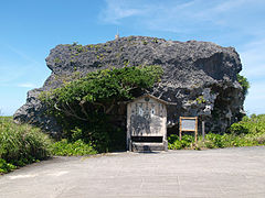 Obi Rock on Shimoji island, Miyakojima. The rock is said to have been left by the tsunami.
 Sawada beach on Shimoji island. The rocks are believed to be remnants of the tsunami
Earthquake analysis
[
edit
]
According to the Japanese government publication
Rika-Nenpy?
(
理科年表
) or
Chronological Scientific Tables
,
[2]
the epicenter was 40 km south-southeast of
Ishigaki Island
with a magnitude of 7.4. According to the Mamoru Nakamura Laboratory, University of the Ryukyus, the earthquake was due to the activity of the
fault
east of
Ishigaki
and it is estimated that the magnitude was 7.5.
[3]
[4]
Further simulation led to the activity of
faults
in the Ryukyu
oceanic trench
and the magnitude was 8.0. Also, there is a hypothesis that claims the magnitude was 8.5.
[5]
[6]
The depth was 6 kilometres (3.7 mi).
[7]
This trench lies between the
Philippine Sea Plate
and the
Eurasian Plate
. The disparity in the amount of recorded shaking (maximum 4
JMA
) and the size of the tsunami has led to the interpretation of this event as a
tsunami earthquake
.
[4]
Damage
[
edit
]
Earthquake
[
edit
]
It is considered that the earthquake registered an intensity of 4 (on the Japanese scale) in the
Yaeyama Islands
, and the damage by the earthquake itself was not as serious as the ensuing tsunami.
Tsunami
[
edit
]
The dead and missing amounted to 12,000 people, and more than 2,000 houses were destroyed on
Ishigaki
and
Miyakojima
.
[8]
It has been estimated local agriculture was severely damaged because of sea water invasion and the population decreased to about one third of what it was before the earthquake. On Ishigaki island, the
run-up
was first estimated around 40 to 80 meters high from historical documents. However, taking into account the rough precision of the measuring instruments at this time and considering geomorphological parameters, the maximal run-up has been re-estimated to ~30m.
[9]
Following the tsunami, the damage it caused was such that it led to a famine that lasted for 80 years.
[8]
Boulders
[
edit
]
 Ishigaki takakoruse ishi, boulder dragged on land by the tsunami. It was moved approximately on 55m.
[9]
Ishigaki takakoruse ishi, boulder dragged on land by the tsunami. It was moved approximately on 55m.
[9]
There are many huge boulders on the coasts of the Yaeyema and Miyako islands that are believed to have been deposited by
tsunamis
. There was a legend that an
islet
disappeared, but this has never been verified. This set of rocks are called the
Ishigaki East Coast Tsunami Rocks
.
[8]
Among them, Yasura-ufukane, Amatariya?Suuari and Taka-koru sishi have been dragged by the 1771 Meiwa tsunami.
[9]
See also
[
edit
]
|
|---|
| Historical
| |
|---|
| 20th century
| |
|---|
| 21st century
| |
|---|
| Related articles
| |
|---|