City in Kentucky, United States
Ashland, Kentucky
|
|---|
|
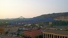
 Downtown Ashland in 2019
|
 Flag
 Logo
|
| Motto:
A proud past. A bright future.
|
 Location of Ashland in Boyd County, Kentucky
|
Location in Kentucky
Show map of Kentucky
Location in the United States
Show map of the United States
|
| Coordinates:
38°27′50″N
082°38′30″W
/
38.46389°N 82.64167°W
/
38.46389; -82.64167
|
| Country
| United States
|
|---|
| State
| Kentucky
|
|---|
| County
| Boyd
|
|---|
| Settled
| Poage's Landing, 1786
|
|---|
| Incorporated
| Ashland, 1854
|
|---|
|
| ?
Mayor
| Matt Perkins
|
|---|
| ?
City Manager
| Michael Graese
|
|---|
|
| ?
City
| 10.77 sq mi (27.89 km
2
)
|
|---|
| ? Land
| 10.73 sq mi (27.80 km
2
)
|
|---|
| ? Water
| 0.03 sq mi (0.08 km
2
)
|
|---|
| Elevation
| 551 ft (168 m)
|
|---|
|
| ?
City
| 21,625
|
|---|
| ? Estimate
| 21,342
|
|---|
| ? Density
| 2,014.44/sq mi (777.76/km
2
)
|
|---|
| ?
Metro
| 376,155 (US:
150th
)
|
|---|
| Time zone
| UTC−5
(
EST
)
|
|---|
| ? Summer (
DST
)
| UTC−4
(EDT)
|
|---|
| ZIP codes
| 41101, 41102, 41105
|
|---|
| Area code
| 606
|
|---|
| FIPS code
| 21-02368
|
|---|
| GNIS
feature ID
| 0486092
|
|---|
| Website
| www
.ashlandky
.gov
|
|---|
Ashland
is a
home rule-class city
[3]
in
Boyd County, Kentucky
, United States. The largest city in Boyd County, Ashland is located upon a southern bank of the
Ohio River
at the state border with
Ohio
and near
West Virginia
. The population was 21,625 at the
2020 census
.
[4]
Ashland is a principal city of the
Huntington?Ashland metropolitan area
, referred to locally as the "Tri-State area", home to 376,155 residents as of 2020.
[1]
Ashland serves as an important economic and medical center for
northeastern Kentucky
.
History
[
edit
]
Ashland dates back to the migration of the Poage family from the
Shenandoah Valley
via the
Cumberland Gap
in 1786. They erected a homestead along the
Ohio River
and named it Poage's Landing.
[5]
Also called Poage Settlement, the community that developed around it remained an extended-family affair until the mid-19th century.
[6]
In 1854, the city name was changed to Ashland, after
Henry Clay
's
Lexington
estate
and to reflect the city's growing industrial base. The city's early industrial growth was a result of
the Ohio
Valley's
pig iron
industry and, particularly, the 1854 charter of the Kentucky Iron, Coal, and Manufacturing Company by the
Kentucky General Assembly
.
[6]
The city was formally incorporated by the General Assembly two years later in 1856.
[7]
Major industrial employers in the first half of the 20th century included
Armco
,
Ashland Oil and Refining Company
, the
C&O Railroad
,
Allied Chemical & Dye Company
's Semet Solvay, and
Mansbach Steel
.
Geography
[
edit
]
 Downtown Ashland
Ashland lies within the
ecoregion
of the
Western Allegheny Plateau
.
[8]
According to the
United States Census Bureau
, the city has a total area of 10.8 square miles (27.9 km
2
), of which 10.7 square miles (27.8 km
2
) is land and 0.039 square miles (0.1 km
2
), or 0.30%, is water.
[4]
Cityscape
[
edit
]
Ashland's central business district extends from 12th Street to 18th Street, and from Carter Avenue to Greenup Avenue. It includes many historically preserved and notable buildings, such as the
Paramount Arts Center
and the Ashland Bank Building, which serves as a reminder of what Ashland leaders hoped the city would become.
Climate
[
edit
]
Ashland is in the
humid subtropical climate
zone, and distinctly experiences all four seasons, with vivid fall foliage and occasional snow in winter. The average high is 88 °F in July, the warmest month, with the average lows of 19 °F occurring in January, the coolest month. The highest recorded temperature was 105 °F in July 1954. The
lowest recorded temperature was ?25 °F in January 1994
. Average annual precipitation is 42.8 inches (1,090 mm), with the wettest month being July, averaging 4.7 inches (120 mm).
| Climate data for Ashland, Kentucky (1991?2020 normals, extremes 1897?present)
|
| Month
|
Jan
|
Feb
|
Mar
|
Apr
|
May
|
Jun
|
Jul
|
Aug
|
Sep
|
Oct
|
Nov
|
Dec
|
Year
|
| Record high °F (°C)
|
80
(27)
|
80
(27)
|
92
(33)
|
94
(34)
|
106
(41)
|
103
(39)
|
107
(42)
|
105
(41)
|
101
(38)
|
93
(34)
|
85
(29)
|
82
(28)
|
107
(42)
|
| Mean daily maximum °F (°C)
|
39.8
(4.3)
|
44.4
(6.9)
|
53.9
(12.2)
|
66.6
(19.2)
|
74.7
(23.7)
|
82.5
(28.1)
|
85.4
(29.7)
|
84.3
(29.1)
|
78.2
(25.7)
|
66.6
(19.2)
|
54.0
(12.2)
|
43.9
(6.6)
|
64.5
(18.1)
|
| Daily mean °F (°C)
|
31.2
(?0.4)
|
34.3
(1.3)
|
42.7
(5.9)
|
53.9
(12.2)
|
62.9
(17.2)
|
71.5
(21.9)
|
75.0
(23.9)
|
73.6
(23.1)
|
66.9
(19.4)
|
54.7
(12.6)
|
43.2
(6.2)
|
35.5
(1.9)
|
53.8
(12.1)
|
| Mean daily minimum °F (°C)
|
22.5
(?5.3)
|
24.3
(?4.3)
|
31.5
(?0.3)
|
41.1
(5.1)
|
51.2
(10.7)
|
60.6
(15.9)
|
64.6
(18.1)
|
62.8
(17.1)
|
55.6
(13.1)
|
42.7
(5.9)
|
32.3
(0.2)
|
27.0
(?2.8)
|
43.0
(6.1)
|
| Record low °F (°C)
|
?25
(?32)
|
?23
(?31)
|
?9
(?23)
|
9
(?13)
|
20
(?7)
|
30
(?1)
|
34
(1)
|
30
(?1)
|
27
(?3)
|
10
(?12)
|
2
(?17)
|
?18
(?28)
|
?25
(?32)
|
| Average
precipitation
inches (mm)
|
3.51
(89)
|
3.69
(94)
|
4.36
(111)
|
3.85
(98)
|
4.85
(123)
|
4.46
(113)
|
4.58
(116)
|
3.91
(99)
|
3.32
(84)
|
2.97
(75)
|
2.98
(76)
|
4.20
(107)
|
46.68
(1,186)
|
| Average precipitation days
(≥ 0.01 in)
|
12.1
|
11.4
|
12.7
|
12.0
|
12.0
|
11.4
|
10.9
|
8.6
|
8.4
|
9.1
|
9.5
|
11.8
|
129.9
|
| Source: NOAA
[9]
[10]
|
Demographics
[
edit
]
Historical population
| Census
| Pop.
| Note
| %±
|
|---|
| 1870
| 1,459
| | ?
|
|---|
| 1880
| 3,280
| | 124.8%
|
|---|
| 1890
| 4,195
| | 27.9%
|
|---|
| 1900
| 6,800
| | 62.1%
|
|---|
| 1910
| 8,688
| | 27.8%
|
|---|
| 1920
| 14,729
| | 69.5%
|
|---|
| 1930
| 29,074
| | 97.4%
|
|---|
| 1940
| 29,537
| | 1.6%
|
|---|
| 1950
| 31,131
| | 5.4%
|
|---|
| 1960
| 31,283
| | 0.5%
|
|---|
| 1970
| 29,245
| | ?6.5%
|
|---|
| 1980
| 27,064
| | ?7.5%
|
|---|
| 1990
| 23,622
| | ?12.7%
|
|---|
| 2000
| 21,981
| | ?6.9%
|
|---|
| 2010
| 21,684
| | ?1.4%
|
|---|
| 2020
| 21,625
| | ?0.3%
|
|---|
| 2022 (est.)
| 21,342
| [11]
| ?1.3%
|
|---|
|
As of 2021, there were 21,476 people, 8,859 households, and 6,192 families residing in the city. The population density was 1,984.4 inhabitants per square mile (766.2/km
2
). There were 10,763 housing units at an average density of 971.7 per square mile (375.2/km
2
). The racial makeup of the city was 91.3%
White
, 1.6%
African American
, 0.6%
Asian
, 2.7% Hispanic or Latino, and 3.7% from two or more races.
There were 9,675 households, out of which 26.8% had children under the age of 18 living with them, 47.4% were
married couples
living together, 13.5% had a female householder with no husband present, and 36.0% were non-families. 33.1% of all households were made up of individuals, and 16.0% had someone living alone who was 65 years of age or older. The average household size was 2.23 and the average family size was 2.82.
In the city, the population was spread out, with 21.9% under the age of 18, 8.0% from 18 to 24, 26.5% from 25 to 44, 23.7% from 45 to 64, and 19.9% who were 65 years of age or older. The median age was 41 years. For every 100 females, there were 83.9 males. For every 100 females age 18 and over, there were 79.3 males.
The median income for a household in the city was $45,414. Males had a median income of $35,362 versus $23,994 for females. The
per capita income
for the city was $26,101. About 23% of the population were below the
poverty line
, including 28.3% of those under age 18 and 12.3% of those age 65 or over.
Economy
[
edit
]
American Rolling Mill Co. (ARMCO) opened its steel mill, Ashland Works, in 1922. The facility grew to cover 700 acres (280 ha) along the Ohio River. It set world records in production, and eventually employed about 7,000 people.
[13]
[14]
Local
scrap
drives were held during World War II to support production at the plant.
[15]
ARMCO Steel
partnered with Kawasaki Steel Corporation in 1994.
[16]
AK Steel eventually purchased Armco Steel Inc. At one time, Armco employed over 4,000 people at its West Works, Foundry, and Coke Plant. AK Steel employed under 1,000 after the closing of the Foundry and Coke Plant and the downsizing of its West Works. AK shut down completely in 2019.
[13]
[17]
Arts and culture
[
edit
]
 The
Paramount Arts Center
The
Paramount Arts Center
Annual cultural events and fairs
[
edit
]
- Festival of Trees
- Poage Landing Days
- Summer Motion
- Winter Wonderland of Lights
- Firkin Fest craft beer festival
- My Old Kentucky Herf (Largest Cigar Festival in KY, OH and WV)
Historical structures and museums
[
edit
]
The
Paramount Arts Center
, an
Art Deco
style movie theater built in 1930, is located on Winchester Avenue. The converted theater serves as an important venue for the arts in eastern Kentucky and the neighboring sections of
Ohio
and
West Virginia
. It is well noted for its Festival of Trees event during the winter season. The Paramount is also devoted to teaching children the importance of the arts. Summer classes are offered for school-age children.
Also along Winchester Avenue is the
Highlands Museum and Discovery Center
. Among its numerous exhibits, one about Country Music Heritage pays tribute to the music artists from along
U.S. Route 23
in Kentucky. Two locals,
The Judds
from Ashland, and
Billy Ray Cyrus
from nearby
Flatwoods
, are included.
The Pendleton Art Center, formed in 2005, is located within the downtown. The works produced include paintings, stained glass, carved gourds, and wood carvings by local artists. They are displayed at the Pendleton the first Friday and Saturday of every month and at other times by appointment.
The Jesse Stuart Foundation, an organization dedicated to the preservation of the literary legacy of
Jesse Stuart
and other
Appalachian
writers, was at one time located within an earshot of the Pendleton Arts Center. Jesse Stuart, a well-known 20th-century author, was from nearby
Greenup, Kentucky
.
Parks and recreation
[
edit
]
 Central Park
Ashland boasts a 47-acre (190,000 m
2
) Central Park.
In July 1976, a new10-acre (40,000 m
2
) park at the former Clyffeside Park was envisioned.
[6]
Named after Commissioner Johnny Oliverio, it features several baseball diamonds, and is located along Winchester Avenue near 39th Street.
In 2004, the AK Steel Sports Park was constructed along Blackburn Avenue in South Ashland. The sports-oriented park features several baseball diamonds, soccer fields and an incomplete skate park.
[6]
Government
[
edit
]
 President
Bill Clinton
addressing a crowd in Ashland in 1996
President
Bill Clinton
addressing a crowd in Ashland in 1996
Local government
[
edit
]
Ashland is governed by a City Manager form of government.
[18]
The government switched from a council-manager to a city commissioner-manager form of government in 1950.
[19]
The City Manager is the chief administrative officer for the city who reports to a Board of Commissioners. Department heads ranging from the Police to Public Works report to the City Manager. The City Manager is currently Michael Graese.
The
Mayor of Ashland
is elected for a four-year term and is not term-limited. The mayor presides over City Commission meetings, is a voting member of the City Commission and represents the city at major functions. The current mayor is Matt Perkins.
Ashland's current City Commission members are Mayor Matt Perkins and Commissioners Josh Blanton, Amanda Clark, Marty Gute and Cheryl Wooten Spriggs.
In 1925, a new city hall was erected at the corner of 17th Street and Greenup Avenue.
[19]
Federal representation
[
edit
]
The
Federal Bureau of Prisons
operates the
Federal Correctional Institution, Ashland
in
Summit
,
unincorporated
Boyd County
,
[20]
[21]
5 miles (8.0 km) southwest of central Ashland.
[22]
The
United States Postal Service
operates the Ashland Post Office and the Unity Contract Station.
[23]
[24]
The
United States District Court for the Eastern District of Kentucky
maintains courtroom and office facilities in the Carl D. Perkins United States Courthouse & Federal Building in downtown Ashland.
[25]
Education
[
edit
]
 Ashland Community and Technical College
All public schools within city limits are operated by the
Ashland Independent School District
. Public schools outside of city limits are operated by the Boyd County School District and the Fairview Independent School District. Some portions of the city limits are in the Boyd and Fairview school districts.
[26]
Ashland has five public elementary schools, Hager Elementary, Oakview Elementary, Crabbe Elementary School, Poage Elementary and Charles Russell Elementary. Hatcher Elementary closed its doors in Spring 2010. Its students and much of its resources were consolidated with the other elementary schools in Fall 2010.
[27]
The former Hatcher Elementary building now serves as the Ashland Independent Schools Central Office.
There is one public middle school, Ashland Middle School, formerly known as George M. Verity Middle School and Putnam Junior High School.
[28]
[29]
The campus is home to Putnam Stadium which serves as the home field for Ashland Tomcats high school and middle school football.
One public high school serves the city of Ashland:
Paul G. Blazer High School
, named after philanthropist
[30]
and founder of
Ashland Inc.
,
[31]
Paul G. Blazer
. The high school is home to the Ashland Tomcats and Kittens athletic teams. The Ashland Tomcats football program has achieved 11 state championships. The Ashland Tomcats (boys') basketball program has accomplished 1 national championship, 4 state championships, 32 regional championships, and 55 district championships. The Ashland Tomcats and Kittens (girls') soccer teams play at the Ashland Soccer Complex at the high school. The school's marching band competes in the AAA class of the
Kentucky Music Educators Association
(KMEA). The marching band is commonly called "The Pride of Blazer" for its excellent performance in many KMEA marching band competitions.
Westwood
, an unincorporated community just outside the Ashland city limits, is served by the Fairview Independent School District. The district operates Fairview High School, grades 6?12, and Fairview Elementary School, grades K-5.
The Boyd County Public Schools serves the rural part of Ashland and the remainder of Boyd County. It has four elementary schools, those being Ponderosa Elementary, Cannonsburg Elementary, Catlettsburg Elementary and Summit Elementary. Boyd County Middle School serves grades 6?8, while Boyd County High School serves grades 9?12.
The two private schools serving the Ashland area are the
Holy Family School
and the Rose Hill Christian School. Holy Family is affiliated with Holy Family Catholic Church and currently offers K?12 education. Rose Hill is affiliated with the Rose Hill Baptist Church and also offers K?12.
Post-secondary educational opportunities include
Ashland Community and Technical College
, which has multiple campuses within the city.
Morehead State University
also has a satellite campus located in Ashland.
The main branch of the Boyd County
Public Library
is located in Ashland.
[32]
Media
[
edit
]
Newspapers
[
edit
]
Ashland is home to two newspapers:
The Independent
and
The Greater Ashland Beacon
.
The Daily Independent
is a five-day morning
daily newspaper
which covers the city and the surrounding metropolitan area. In addition, it offers national, state and regional news/sports coverage via reprints of Associated Press and
CNHI
wire reports and columns. The newspaper is often called "The Independent" or the "Ashland Daily Independent" by locals, as these were its former names. One of the paper's claims to fame is the first printings of a supposed image of Jesus in the clouds of
Korea
in 1951.
[33]
Ashland's other newspaper is
The Greater Ashland Beacon
. It is a free weekly circular published in full color every Tuesday. "The Beacon", as it is known by locals, is "hyper-local," meaning it is exclusively dedicated to covering the community. Highlights include, but are not limited to, local events, sports results, outdoor recreation and personal interest articles and columns penned by freelance Ashland-area journalists and quasi-celebrities.
[34]
Radio
[
edit
]
| Call sign
|
Frequency
|
Format
|
Description / Notes
|
| WKAO
|
91.1 FM
|
Contemporary Christian music
|
Owned by Positive Alternative Radio, Inc. Licensed to Ashland and identifies as
"Walk FM"
.
|
| WDGG
|
93.7 FM
|
Country
|
Owned by Kindred Communications. Licensed to Ashland with studios located in
Huntington, West Virginia
. Identifies as
"93.7 The Dawg"
.
|
| WKSG
|
98.3 FM
|
Southern gospel
|
Licensed to nearby
Garrison, Kentucky
with its transmitter tower located just outside of Garrison in
Greenup County, Kentucky
and its studios located in
Portsmouth, Ohio
. Identifies as
"Hot 98.3"
.
|
| WLGC-FM
|
105.7 FM
|
Oldies
|
Owned by Greenup County Broadcasting, Inc. Licensed to nearby
Greenup, Kentucky
with studios located in downtown Ashland. Identifies as
"Kool Hits 105.7"
.
|
| WCMI
|
1340 AM
|
Sports talk
|
Owned by Kindred Communications. It was founded by the Ashland Broadcasting Station whose owners were the Daily Independent on April 29, 1935.
[19]
It was sold to Nunn Enterprises in 1939. Identifies as
"CAT Sports 93-3 and 1340"
.
|
| WOKT
|
1080 AM
|
Christian Talk & Teaching
|
Located in adjacent
Cannonsburg
, it is owned by Fowler Media Partners of South Point, Ohio. It currently simulcasts its programming on "WJEH" 990 AM of Gallipolis, Ohio.. Identifies as
"The Tri-State's 24 Hour Christian Talk and Information Station "
.
|
Television
[
edit
]
Ashland residents receive their network television primarily from stations in
Huntington
and
Charleston, West Virginia
. In addition,
WKYT
, the
CBS
affiliate in
Lexington, Kentucky
, is shown on
cable TV
in Ashland when its programming is different from Charleston's CBS affiliate
WOWK
. There are also two television stations licensed to Ashland itself. Those are:
Infrastructure
[
edit
]
Transportation
[
edit
]
Located just northwest of the city in
Worthington
is the
Ashland Regional Airport
. This airport is used for general aviation. The then-named
Ashland-Boyd County Airport
opened in 1953 and featured a 5,600 ft (1,700 m). runway with a 3,000 ft (910 m). clearance.
[19]
Tri-State Airport
, located in nearby
Huntington, West Virginia
, provides commercial aviation services for the city.
Rail
[
edit
]
Amtrak
serves Ashland with the three-days-a-week
Cardinal
, connecting
New York City
,
Washington
,
Charlottesville, VA
,
Cincinnati
,
Indianapolis
, and
Chicago
. Westbound trains are scheduled to stop Sunday, Wednesday, Friday in the late evening. Eastbound the stops are early morning Wednesday, Friday, Sunday. The Amtrak station is located at the
Ashland Transportation Center
, formerly the
Chesapeake and Ohio Railway
freight depot, located on 15th Street near the
Ohio River
. It does not have an Amtrak ticket counter or QuikTrak ticket machine, but E-tickets can be obtained from either Amtrak's
website
or
mobile app
.
The former C&O passenger depot, at 11th Street and Carter Avenue, had been completed in 1925 but abandoned in the 1970s in favor of a downsized depot in nearby
Catlettsburg
.
[19]
The rail lines to the building have since been removed. Today the building itself serves as the downtown branch of
PNC Bank
. Passenger rail service was moved from Catlettsburg to the Ashland Transportation Center in March 1998.
 Ben Williamson
and
Simeon Willis
Memorial Bridges connect Ashland to Southern Ohio
Ben Williamson
and
Simeon Willis
Memorial Bridges connect Ashland to Southern Ohio
Greyhound Lines
is the main provider of intercity bus transportation out of Ashland. It operates out of the
Ashland Transportation Center
, along with the
Ashland Bus System
that provides five local bus routes. Mor'Trans, Licking Valley Community Action, Sandy Valley Transportation Services and Northeast Kentucky Community Action Agency provide connections to Ashland from surrounding counties.
[35]
[36]
[37]
[38]
Roads
[
edit
]
Ashland is served by
US 23
and
US 60
, several state routes, and is in close proximity to
US 52
and
Interstate 64
. The state routes include:
- KY 5
never enters the city limits of Ashland, however does serve a sizable area surrounding the city.
- KY 168
crosses through the south Ashland region and is referred to as Blackburn Avenue and South Belmont Street.
- KY 766
Connects US 60 and 13th Street with
KY 5
- KY 1012
is known as Boy Scout Road.
- KY 1134
Law enforcement
[
edit
]
In the late 19th century, what is now the Ashland Police Department was organized when the town was still known as Poage's Landing.
[18]
The first executive officer was a town
marshal
, who was soon replaced by a professional police department.
The city of Ashland currently has 49 sworn officers, three civilian employees who function as administrative support and six parapolice who handle tasks that do not require the services of a sworn officer.
[18]
Healthcare
[
edit
]
 UK King's Daughters
is Ashland's largest employer
UK King's Daughters
is Ashland's largest employer
UK King's Daughters
, formerly known as King's Daughters Medical Center, is the fourth largest hospital in Kentucky The 465-bed facility, which was purchased by the
University of Kentucky
in December 2022, is the city's largest employer at over 4,000 employees.
[39]
It offers numerous inpatient and outpatient services for the region.
In addition to UK King's Daughters, another hospital, the Ashland Tuberculosis Hospital, was located on a hill above U.S. Route 60 in the Western Hills section of the city and opened in 1950.
[19]
It featured 100 beds and served 18 eastern Kentucky counties. It has long since been closed due to the discovery of antibiotics that successfully treat tuberculosis, eliminating its necessity. The facility has since been used as a state office building and is now owned by Safe Harbor, a secure domestic violence shelter and advocacy center.
Notable people
[
edit
]
- Allison Anders
, filmmaker and director
- Claria Horn Boom
, U.S. federal judge
- Billy Ray Cyrus
, country music singer, born and raised in
Flatwoods, Kentucky
, just outside Ashland
- Trace Cyrus
, musician
- Mark Fosson
, musician/songwriter
- Leigh French
, actress
- Jillian Hall
,
WWE Diva
- Mabel Hite
, vaudeville and musical comedy performer
- Chris Jennings
, running back for NFL's
Cleveland Browns
- The Judds
, country music duo of mother
Naomi
and daughter
Wynonna
- Steve Kazee
, Broadway and film actor
- Sonny Landham
, actor and former Kentucky gubernatorial candidate
- Michele Mahone
, entertainment reporter,
NINE Network, Australia
- Venus Ramey
, first red-haired
Miss America
in 1944
- Charlie Reliford
,
Major League Baseball
umpire
- Julie Reeves
, country music singer
- Jay Rhodemyre
, former
NFL
center
- Charles Manson
, leader of the Manson Family, killer
- Don Robinson
, former
Major League Baseball
pitcher
- Robert Smedley
,
professional wrestler
for
World Championship Wrestling
and
World Wrestling Entertainment
as Bobby Blaze
- Jean Bell Thomas
, proprietress of American Folk Song Festival in Ashland area 1930 - 1972
- Alberta Vaughn
, actress
- Brandon Webb
, pitcher for
Major League Baseball
's
Arizona Diamondbacks
, 2006 National League
Cy Young Award
winner
- Keith Whitley
, country music singer
- Chuck Woolery
, game show host
In popular culture
[
edit
]
- Ashland, Kentucky is mentioned at the beginning of Part 4 Chapter 2 in
On the Road
by
Jack Kerouac
.
- Ashland, Kentucky is mentioned as the location of the Rebel-Georgian Coalition camp in the
NBC
television series
Revolution
Episode 1.17 "The Longest Day" first aired May 13, 2013.
References
[
edit
]
- Historical populations from
A history of Ashland, Kentucky, 1786-1954
, Ashland Centennial Committee, 1954, and
Ashland City Directory
, 1985.
- ^
a
b
"2020 U.S. Gazetteer Files"
. United States Census Bureau
. Retrieved
March 18,
2022
.
- ^
"Annual Estimates of the Resident Population for Incorporated Places in Kentucky: April 1, 2020 to July 1, 2022"
. United States Census Bureau
. Retrieved
May 26,
2023
.
- ^
"Summary and Reference Guide to House Bill 331 City Classification Reform"
(PDF)
. Kentucky League of Cities
. Retrieved
December 30,
2014
.
- ^
a
b
"Geographic Identifiers: 2010 Demographic Profile Data (G001): Ashland city, Kentucky"
. U.S. Census Bureau, American Factfinder. Archived from
the original
on February 12, 2020
. Retrieved
January 18,
2013
.
- ^
Ashland History (2008 Baldridge, Terry L. and Powers, James C.)
- ^
a
b
c
d
A History of Ashland, Kentucky, 1854?2004
. Ashland Bicentennial Committee. 2004. January 2, 2007.
- ^
Commonwealth of Kentucky. Office of the Secretary of State. Land Office. "Ashland, Kentucky." Accessed July 15, 2013.
- ^
"Level III Ecoregions of Kentucky"
. National Health and Environmental Effects Research Laboratory, U.S. Environmental Protection Agency
. Retrieved
June 13,
2015
.
- ^
"NowData ? NOAA Online Weather Data"
. National Oceanic and Atmospheric Administration
. Retrieved
June 4,
2021
.
- ^
"Station: Ashland, KY"
.
U.S. Climate Normals 2020: U.S. Monthly Climate Normals (1991?2020)
. National Oceanic and Atmospheric Administration
. Retrieved
June 4,
2021
.
- ^
"Annual Estimates of the Resident Population for Incorporated Places in Kentucky: April 1, 2020 to July 1, 2022"
. United States Census Bureau
. Retrieved
May 26,
2023
.
- ^
"Census of Population and Housing"
. Census.gov
. Retrieved
June 4,
2015
.
- ^
a
b
Stein, Jeff (October 25, 2019).
"As a Kentucky mill shutters, steelworkers see the limits of Trump's intervention"
.
The Washington Post
. Archived from
the original
on October 26, 2019
. Retrieved
October 26,
2019
.
- ^
"AK Steel Locations: Ashland Works in Ashland, Kentucky"
.
www.aksteel.com
. Archived from
the original
on March 30, 2019
. Retrieved
October 26,
2019
.
- ^
Daniel, Jerry.
WWII Scrap Drive in Downtown Ashland
,
archived
from the original on December 11, 2021
, retrieved
October 26,
2019
- ^
Hicks, Jonathan P. (April 6, 1989).
"Talking Deals; Armco's Accord With Kawasaki"
.
The New York Times
.
- ^
Maynard, Mark (January 29, 2019).
"AK Steel announces plans to shutter remaining operations at Ashland Works by end of 2019"
.
KyForward.com
. Retrieved
October 26,
2019
.
- ^
a
b
c
"Ashland Police Department." Ashland Police Department. December 30, 2006
[1]
.
- ^
a
b
c
d
e
f
"A history of Ashland, Kentucky, 1786?1954." Ashland Centennial Committee. 1954. January 2, 2007.
- ^
"
Admissions & Orientation (A&O) Handbook
." Federal Correctional Institution, Ashland. 1 (1/51). Retrieved on February 1, 2011. "The Federal Correctional Institution of Ashland, Kentucky, is located five miles southwest of Ashland in Summit, Kentucky."
- ^
"
FCI Ashland Contact Information
."
Federal Bureau of Prisons
. Retrieved on February 1, 2011. "FCI ASHLAND FEDERAL CORRECTIONAL INSTITUTION ST. ROUTE 716 ASHLAND, KY 41105."
- ^
"
FCI Ashland
."
Federal Bureau of Prisons
. Retrieved on February 1, 2011.
- ^
"
Post Office™ Location - ASHLAND
Archived
July 12, 2011, at the
Wayback Machine
."
United States Postal Service
. Retrieved on February 1, 2011.
- ^
"
Post Office™ Location - UNITY CONTRACT STATION
Archived
January 20, 2012, at the
Wayback Machine
."
United States Postal Service
. Retrieved on February 1, 2011.
- ^
"Ashland | Eastern District of Kentucky | United States District Court"
.
- ^
"2020 CENSUS - SCHOOL DISTRICT REFERENCE MAP: Boyd County, KY"
(PDF)
.
U.S. Census Bureau
. Retrieved
July 24,
2022
.
-
Text list
- For more detailed boundaries of the independent school districts see:
"Appendix B: Maps Of Independent School Districts In Operation In FY 2014-FY 2015 Using 2005 Tax District Boundaries ? Ashland ISD / Fairview ISD"
(PDF)
.
Research Report No. 415 ? Kentucky's Independent School Districts: A Primer
. Frankfort, KY: Office of Education Accountability, Legislative Research Commission. September 15, 2015. pp. 87 (Ashland) and 108 (Fairview) (PDF p. 101, 122/174).
- ^
[2]
, Mike, James. "Goodbye to Hatcher."
The Independent
. May 30, 2010. Access date: June 5, 2010.
- ^
[3]
, Maynard, Mark. "Board votes to change Verity to Ashland Middle School."
The Independent
. December 19, 2013. Access date: August 17, 2014.
- ^
[4]
, James, Mike. "It's Ashland Middle School now."
The Independent
. August 13, 2014. Access date: August 17, 2014.
- ^
"Minutes of the Meeting of the Board of Trustees of the University of Kentucky, "notes with sorrow the death of PAUL G. BLAZER, SR.", December 13, 1966"
.
- ^
"
"E Pluribus Unum!" "One Out of Many" An Oil Company Grows Through Acquisitions, An Address at Lexington by member Paul G. Blazer, American Newcomen Society, copyright 1956 (pages 5 & 6)"
(PDF)
. Archived from
the original
(PDF)
on December 1, 2008
. Retrieved
March 11,
2015
.
- ^
"Kentucky Public Library Directory"
. Kentucky Department for Libraries and Archives. Archived from
the original
on January 11, 2019
. Retrieved
June 5,
2019
.
- ^
"Jesus in the Clouds"
. snopes.com
. Retrieved
May 22,
2012
.
- ^
"The Greater Ashland Beacon"
.
- ^
http://www.ftsb.org/intercity-bus-mortrans.html
- ^
https://www.lvcap.com/services/public-transport/
- ^
http://nkcaa.net/programs/transportation-services/
- ^
http://www.svtransport.org/Intercity/Intercity.html
- ^
"About KDMC." King's Daughters Medical Center. December 31, 2006
"King's Daughters Medical Center | About KDMC"
. Archived from
the original
on January 9, 2007
. Retrieved
2007-01-01
.
.
External links
[
edit
]
|
|---|
| Subject areas
| | |
|---|
| Top subjects
| |
|---|
| Prominent suburbs
| |
|---|
|
|---|
| Principal cities
| | |
|---|
Municipalities with population
over 5,000
| |
|---|
Municipalities with population
1,000?5,000
| |
|---|
Municipalities with population
under 1,000
| |
|---|
| West Virginia counties
| |
|---|
| Kentucky counties
| |
|---|
| Ohio counties
| |
|---|
|
|---|
| Counties
| |
|---|
Cities and towns
Over 10k
| |
|---|
Cities and towns
5k-10k
| |
|---|
Cities and towns
1k-5k
| |
|---|
Cities and towns
under 1k
| |
|---|
| Statistical areas
| |
|---|
| See also
| |
|---|
|
|---|
| International
| |
|---|
| National
| |
|---|
| Geographic
| |
|---|
| Other
| |
|---|