"Atlantic Seaboard" redirects here. For other seaboards, see
Atlantic Coast
.
The
East Coast of the United States
, also known as the
Eastern Seaboard
, the
Atlantic Coast
, and the
Atlantic Seaboard
, is the region encompassing the
coastline
where the
Eastern United States
meets the
Atlantic Ocean
. The
Thirteen Colonies
, which formed the United States in 1776 were located on this coast, and it has played an important role in the development of the United States.
The region is generally understood to include the
U.S. states
that border the Atlantic Ocean:
Connecticut
,
Delaware
,
Florida
,
Georgia
,
Maine
,
Maryland
,
Massachusetts
,
New Hampshire
,
New Jersey
,
New York
,
North Carolina
,
Rhode Island
,
South Carolina
, and
Virginia
, as well as the federal capital of
Washington, D.C.
, and non-coastline states:
Pennsylvania
,
Vermont
, and
West Virginia
.
[2]
Toponymy and composition
edit
The
place name
East Coast derives from the idea that the contiguous 48 states are defined by two major coastlines, one at the
western edge
and one on the eastern edge. Other terms for referring to this area include the Eastern
Seaboard
, which is another term for coastline,
[3]
Atlantic Coast, and Atlantic Seaboard because the coastline lies along the
Atlantic Ocean
.
The 14 states that have a shoreline on the Atlantic Ocean are (from north to south):
Maine
,
New Hampshire
,
Massachusetts
,
Rhode Island
,
Connecticut
,
New York
,
New Jersey
,
Delaware
,
Maryland
,
Virginia
,
North Carolina
,
South Carolina
,
Georgia
, and
Florida
.
[4]
Pennsylvania
and
Washington, D.C.
border the
Delaware River
and the
Potomac River
, respectively, both of which are
tidal arms
of the Atlantic Ocean.
Geography and climate
edit
 Climate map of the contiguous
United States
, according to the
Trewartha climate classification
Climate map of the contiguous
United States
, according to the
Trewartha climate classification
 Aerial view of the
Virginia Beach
entrance to the
Chesapeake Bay Bridge?Tunnel
Aerial view of the
Virginia Beach
entrance to the
Chesapeake Bay Bridge?Tunnel
 South Mountain
in eastern
Pennsylvania
with
Allentown
in the foreground in December 2010
South Mountain
in eastern
Pennsylvania
with
Allentown
in the foreground in December 2010
 The
Fulton Chain of Lakes
in
Adirondack Park
in
Upstate New York
in August 2007
The
Fulton Chain of Lakes
in
Adirondack Park
in
Upstate New York
in August 2007
Three basic climate regions occur on the East Coast according to the
Koppen climate classification
and four occur according to the
Trewartha climate classification
from north to south based on the monthly mean temperature of the coldest month (January) and the number of months averaging above 50 °F (10 °C), respectively.
The region from northern Maine and
Upstate New York
south to most of Connecticut, most of
northern New Jersey
(except for areas close enough to
New York City
), most of Pennsylvania, and
western Maryland
has a
humid continental climate
(
Dfa/Dfb/Dc
), with warm-to-hot summers, cold and snowy winters with at least one month averaging below freezing, and four to seven months with mean temperatures warmer than 50 °F.
The area from
Martha's Vineyard
and
extreme SW Rhode Island
to
southern Delaware
and
western North Carolina
has a warm
temperate climate
(
Cfa
Koppen/
Do
Trewartha) with long and hot summers with at least one month over 22°C (71.6°F), cool winters with all months over freezing, and six to seven months above 50°F. Although winter precipitation is more likely to fall as rain than as snow, occasional heavy snow is possible.
The area from the southern
Delmarva Peninsula
, southeast Virginia, and
central North Carolina
south to central Florida is humid
subtropical
(
Cfa/Cf
), with hot and rainy summers, mild and drier winters, and eight to twelve months above 50°F.
Urban heat island
exclaves of this zone are found north of this area in
Baltimore
and
Washington, D.C.
The region of Florida from the south-central region of the state south to the
Florida Keys
has a
tropical climate
(
Af/Aw/Ar
) that is frost-free, warm to hot all year, and all of the 12 months of the year average above 18 °C (64.4 °F). This region of Florida is the only tropical climate in the continental U.S.
The least common climate on the East Coast is the
oceanic
(
Cfb
/
Do
), which is only found on
Block Island
,
Nantucket
, and areas of
Cape Cod
, and in areas of the southern
Appalachian Mountains
. This zone has all monthly averages between 0 and 22 °C and six to seven months above 50 °F. Although winter precipitation is more likely to fall as rain than as snow, occasional heavy snow is possible.
Seasonally, average monthly precipitation ranges from a slight late fall (November) maximum from
Massachusetts
north to
Portland, Maine
to a slight summer maximum in the
Mid-Atlantic states
from southern Connecticut south to
Virginia
at
Wilmington, Delaware
and
Norfolk, Virginia
, to a more pronounced summer maximum from
Cape Hatteras
in
North Carolina
, southward along the
Southeastern United States
coast to
Savannah, Georgia
. The Florida peninsula has a sharp wet-summer/dry-winter pattern, with 60 to 70% of precipitation falling between June and October in an average year and a dry, and sunny late fall, winter, and early spring.
Although landfalls are rare, the Eastern Seaboard is susceptible to
hurricanes
in the Atlantic hurricane season, officially running from June 1 to November 30, although hurricanes can occur before or after these dates.
[7]
Hurricanes
Hazel
,
Hugo
,
Bob
,
Isabel
,
Irene
, and
Sandy
, and most recently
Florence
,
Isaias
,
Henri
, and
Ida
are some of the more significant storms to have affected the region.
The East Coast, with the exception of eastern Maine, is a low-relief,
passive margin
coast.
[8]
It has been shaped by the
Pleistocene glaciation
in the far northern areas in New England, with offshore islands such as
Nantucket
,
Martha's Vineyard
,
Block Island
, and
Fishers Island
. From
northern New Jersey
southward, the coastal plain broadens southwards, separated from the
Piedmont
region by the
Atlantic Seaboard fall line
of the East Coast rivers, often marking the head of navigation and prominent sites of cities.
The coastal areas from
Long Island
south to Florida are often made up of
barrier islands
that front the coastal areas, with the long stretches of sandy beaches. Many of the larger capes along the lower East Coast are in fact barrier islands, like the
Outer Banks
of North Carolina and
Cape Canaveral
, Florida. The Florida Keys are made up of limestone coral and provide the only
coral reefs
on the U.S. mainland.
In 2010, the population of the states that have shoreline on the East Coast was estimated at 112,642,503 (about 36% of the country's total population).
New York City
is both the largest city and the largest metropolitan area on the East Coast. The East Coast is the most populated coastal area in the United States.
[9]
Major East Coast cities and metropolitan areas
| City
|
City Population (2018 est.)
|
Metro Population (2018 est.)
|
State
|

Alexandria
|
159,428
|
6,216,589
|
 Virginia
|

Allentown
|
125,845
|
861,889
|
 Pennsylvania
|

Atlanta
|
498,044
|
5,949,951
|
 Georgia
|

Augusta
|
196,939
|
600,151
|
Georgia
|
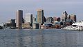
Baltimore
|
602,495
|
2,802,789
|
 Maryland
|

Boston
|
694,583
|
4,628,910
|
 Massachusetts
|

Bridgeport
|
144,900
|
939,904
|
 Connecticut
|
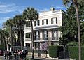
Charleston
|
136,208
|
802,122
|
 South Carolina
|

Charlotte
|
872,498
|
2,636,883
|
 North Carolina
|

Chesapeake
|
244,835
|
1,672,319
|
Virginia
|

Columbia, MD
|
103,467
|
6,216,589
|
Maryland
|

Columbia, SC
|
133,451
|
838,433
|
South Carolina
|

Coral Springs
|
133,507
|
5,762,717
|
 Florida
|

Durham
|
264,310
|
2,106,463
|
North Carolina
|

Edison
|
100,693
|
19,979,477
|
 New Jersey
|

Elizabeth
|
128,885
|
19,979,477
|
New Jersey
|

Fayetteville
|
211,657
|
526,719
|
North Carolina
|

Fort Lauderdale
|
182,595
|
5,762,717
|
Florida
|

Germantown
|
90,494
|
6,216,589
|
Maryland
|

Greenville
|
70,635
|
920,477
|
South Carolina
|

Hampton
|
134,510
|
1,672,319
|
Virginia
|

Hartford
|
122,105
|
1,211,324
|
Connecticut
|
Hialeah
|
238,942
|
5,828,191
|
Florida
|
Hollywood
|
154,823
|
5,762,717
|
Florida
|

Jacksonville
|
903,889
|
1,523,615
|
Florida
|

Jersey City
|
265,549
|
19,979,477
|
New Jersey
|

Miami
|
470,914
|
6,158,824
|
Florida
|

Miami Gardens
|
113,069
|
5,762,717
|
Florida
|

Miramar
|
140,823
|
5,762,717
|
Florida
|

New Haven
|
130,418
|
862,477
|
Connecticut
|

New York City
|
8,398,748
|
19,979,477
|
 New York
|

Newark
|
282,090
|
19,979,477
|
New Jersey
|

Newport News
|
179,225
|
1,672,319
|
Virginia
|

Norfolk
|
244,076
|
1,672,319
|
Virginia
|
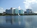
Orlando
|
285,713
|
2,387,138
|
Florida
|

Palm Bay
|
114,194
|
543,376
|
Florida
|

Paterson
|
145,627
|
19,979,477
|
New Jersey
|

Pembroke Pines
|
172,374
|
5,762,717
|
Florida
|

Philadelphia
|
1,584,138
|
6,096,120
|
Pennsylvania
|

Pittsburgh
|
302,971
|
2,370,930
|
Pennsylvania
|

Pompano Beach
|
111,954
|
5,762,717
|
Florida
|

Portland
|
66,417
|
538,500
|
 Maine
Maine
|

Portsmouth
|
94,632
|
1,672,319
|
Virginia
|

Raleigh
|
469,298
|
1,337,331
|
North Carolina
|

Port St. Lucie
|
195,248
|
438,095
|
Florida
|

Providence
|
179,335
|
1,604,291
|
 Rhode Island
|

Richmond
|
228,783
|
1,260,029
|
Virginia
|

Savannah
|
145,862
|
389,494
|
Georgia
|
 Springfield
|
153,606
|
631,982
|
Massachusetts
|

Stamford
|
129,775
|
916,829
|
Connecticut
|

Virginia Beach
|
450,138
|
1,725,246
|
Virginia
|

Washington, D.C.
|
705,749
|
6,216,589
|
 District of Columbia
|
West Palm Beach
|
111,398
|
5,762,717
|
Florida
|

Wilmington, DE
|
70,635
|
6,069,875
|
 Delaware
|

Wilmington, NC
|
122,607
|
282,573
|
North Carolina
|

Woodbridge
|
100,450
|
19,979,477
|
New Jersey
|
 Philadelphia International Airport
in
Philadelphia
in June 2007
Philadelphia International Airport
in
Philadelphia
in June 2007
The primary
Interstate Highway
along the East Coast is
Interstate 95
, completed in 2018,
[10]
[11]
which replaced the historic
U.S. Route 1
(
Atlantic Highway
), the original federal highway that traversed all East Coast states, except
Delaware
.
[12]
By water, the East Coast is connected from
Boston, Massachusetts
to
Miami, Florida
, by the
Intracoastal Waterway
, also known as the East Coast Canal, which was completed in 1912.
[13]
[14]
Amtrak's
Downeaster
and
Northeast Regional
offer the main
passenger rail
service on the Seaboard. The
Acela Express
offers the only
high-speed rail
passenger service in the Americas. Between New York and Boston the
Acela Express
has up to a 54% share of the combined train and air passenger market.
[15]
[16]
Some of the largest airports in the United States are located along the East Coast of the United States, such as
John F. Kennedy International Airport
in
Queens
, New York City,
Logan International Airport
in
Boston
,
Newark Liberty Airport
in
Newark, New Jersey
,
Philadelphia International Airport
in
Philadelphia
,
Baltimore?Washington International Airport
near
Baltimore
,
Dulles International Airport
near
Washington, D.C.
,
Hartsfield?Jackson International Airport
in
Atlanta
,
Miami International Airport
in Miami,
Charlotte Douglas International Airport
in
Charlotte, North Carolina
,
Tampa International Airport
in
Tampa
, and
Orlando International Airport
in
Orlando, Florida
.
 The fast-paced streets of
New York City
, the largest city in the United States, in January 2020
The fast-paced streets of
New York City
, the largest city in the United States, in January 2020
As the first spot in the United States that immigrants arrived and the close proximity of
Europe
, the
Caribbean
, and
Latin America
, the East Coast is home to a diverse population and home to multi-cultures when compared to the rest of the U.S. From the strong
Latin
culture in
southern Florida
, to the 200-year-old
Gullah
culture of the low country coastal islands of
Georgia
and
South Carolina
, to the many historic cities in the
Mid-Atlantic
, where a strong English, German, Italian, Irish, and French culture are present, the East Coast is significantly more diverse than the rest of the United States. Numerous
Chinatowns
in
New York City
, and
Little Havana
in
Miami
, are examples of such cultural centers in the bigger cities.
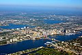
The East Coast is home to much of the political and financial power and a center for resort and travel destinations in the United States.
New York City
is the most populous city in the country and a major world financial center. Seventy-one of the world's Fortune 500 companies have their corporate headquarters in New York City, while
Midtown Manhattan
, with 400 million square feet of office space in 2018, is the largest
central business district
in the world.
Washington, D.C.
is the federal capital and political nerve center of the United States. Many organizations such as defense contractors, civilian contractors, nonprofit organizations, lobbying firms, trade unions, industry trade groups and professional associations have their headquarters in or near Washington, D.C., in order to be close to the
federal government
.
Miami
is one of the top domestic and international travel destinations in the United States. Miami is the warmest major city in the continental United States in winter, which contributes to it being a major tourism hub for international visitors. Miami has one of the largest concentrations of international banks in the United States, and the third-largest skyline in the U.S. with over 439 high-rises, 68 of which exceed 490?ft (149 m).
Port of Miami
is the busiest cruise port in the world in both passenger traffic and cruise lines, with over 5.5 million cruise passengers passing through the port each year. The center for tropical plant culture and research in the United States is based in Miami at
Fairchild Tropical Botanic Garden
. The state of Florida is the second-largest producer of
oranges
in the world behind
Brazil
.
- ^
Those colonies were New Hampshire, Massachusetts Bay, Rhode Island and Providence Plantations, Connecticut, New York, New Jersey, Pennsylvania, Delaware, Maryland, Virginia, North Carolina, South Carolina, and Georgia. While Pennsylvania is not directly along the Atlantic shoreline, it borders the tidal portion of the Delaware River and the city of
Philadelphia
was a major seaport.
- ^
"East Coast States 2020"
.
Archived
from the original on April 12, 2020
. Retrieved
April 12,
2020
.
- ^
East Coast Region Energy Sector Risk Profile
(PDF)
,
US Department of Energy
Office of Electricity Delivery & Energy Reliability
, retrieved
June 7,
2023
- ^
"Seaboard"
.
Collins Dictionary
.
HarperCollins
. Retrieved
September 22,
2022
.
- ^
General Reference Map
Archived
October 17, 2012, at the
Wayback Machine
,
National Atlas of the United States
, 2003.
- ^
"1500-1667 Contact & Conflict"
.
Maine History Online
.
Archived
from the original on September 19, 2018
. Retrieved
September 21,
2018
.
- ^
"A Brief History - Florida Department of State"
.
www.flheritage.com
.
Archived
from the original on October 30, 2012
. Retrieved
November 6,
2012
.
- ^
Neal Dorst.
"Frequently Asked Questions: When is hurricane season?"
. Hurricane Research Division,
NOAA
. Archived from
the original
on May 6, 2009
. Retrieved
March 14,
2016
.
- ^
Gabler, Robert E.; Petersen, James F.; Trapasso, L. Michael; Sack, Dorothy (2008).
Physical Geography
.
Cengage Learning
. p.?575.
ISBN
978-0495555063
.
Archived
from the original on March 15, 2017
. Retrieved
March 14,
2016
.
- ^
2010 Census: Resident Population Data
Archived
October 19, 2013, at the
Wayback Machine
- ^
Griffin, Riley (August 20, 2018).
"After 60 Years, I-95 Is Complete"
.
Bloomberg.com
.
Archived
from the original on October 11, 2018
. Retrieved
January 20,
2019
.
- ^
Geewax, Marilyn (August 20, 2010).
"Starting A Journey On I-95, The Road Most Traveled"
(transcript)
.
NPR.org
.
National Public Radio
.
Archived
from the original on July 30, 2018
. Retrieved
July 30,
2018
.
- ^
"U.S. 1: Fort Kent, Maine to Key West, Florida"
.
Federal Highway Administration
,
U.S. Department of Transportation
. April 7, 2011.
Archived
from the original on March 4, 2016
. Retrieved
March 14,
2016
.
- ^
Reiley, Laura (2008).
Florida Gulf Coast
. Moon Handbooks. p.?373.
ISBN
9781598800821
.
- ^
Maurice J. Robinson (2008).
Ponte Vedra Beach: A History
. History Press. p.?89.
ISBN
9781596294417
.
- ^
Nixon, Ron (August 15, 2012).
"Air Travel's Hassles drive riders to Amtrak's Acela"
.
The New York Times
.
Archived
from the original on July 22, 2016.
(for Acela express passenger numbers only)
- ^
"The Information: Most popular airline routes"
.
Financial Times
. January 17, 2009.
Archived
from the original on January 21, 2009
. Retrieved
February 2,
2010
.