NCEI/WDS Global Significant Earthquake Database, 2150 BC to Present
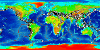 Global plot of significant earthquakes
The Significant Earthquake Database is a global listing of over 5,700 earthquakes
from 2150 BC to the present. A significant earthquake is classified as one that meets
at least one of the following criteria: caused deaths, caused moderate damage (approximately
$1 million or more), magnitude 7.5 or greater, Modified Mercalli Intensity (MMI) X
or greater, or the earthquake generated a tsunami. The database provides information
on the date and time of occurrence, latitude and longitude, focal depth, magnitude,
maximum MMI intensity, and socio-economic data such as the total number of casualties,
injuries, houses destroyed, and houses damaged, and $ dollage damage estimates. References,
political geography, and additional comments are also provided for each earthquake.
If the earthquake was associated with a tsunami or volcanic eruption, it is flagged
and linked to the related tsunami event or significant volcanic eruption.
- Cite as: National Geophysical Data Center / World Data Service (NGDC/WDS): NCEI/WDS
Global Significant Earthquake Database. NOAA National Centers for Environmental Information.
doi:10.7289/V5TD9V7K [access date]
gov.noaa.ngdc.mgg.hazards:G012153
|
| Search Data
|
- NCEI/WDS Global Significant Earthquake Database
(search)
The database contains information for each earthquake such as the date, time, location,
focal depth, magnitude, intensity, and socio-economic data including the total number
of fatalities, injuries, houses damaged, and houses destroyed and $ dollar damage
estimates if available. If the earthquake was associated with a tsunami or volcanic
eruption, it is flagged and linked to the related tsunami event or significant volcanic
eruption.
- Natural Hazards Map Viewer - Significant Earthquakes Layer
(search)
Tsunami source and runup locations, significant earthquake epicenters, significant
volcanic eruption locations.
|
| Download Data
|
- Google Earth KML
(download)
Tsunami source and runup locations, significant earthquake epicenters, significant
volcanic eruption locations.
|
| Distribution Formats
|
|
| Distributor
|
Hazards Data Manager
NOAA National Centers for Environmental Information
haz.info@noaa.gov
|
| Dataset Point of Contact
|
Nicolas Arcos
DOC/NOAA/NESDIS/NCEI > National Centers for Environmental Information, NESDIS, NOAA,
U.S. Department of Commerce
(303) 497-3158
haz.info@noaa.gov
|
|
| Time Period
|
-2150 to Present
|
| Spatial Bounding Box Coordinates
|
West:
-179
East:
180
South:
-63
North:
71
|
| Spatial Coverage Map
|
|
|
| General Documentation
|
|
| Associated Resources
|
- NCEI/WDS Global Historical Tsunami Database, 2100 BC to Present
- NCEI/WDS Global Significant Volcanic Eruptions Database, 4360 BC to Present
- Modified Mercalli Intensity Scale of 1931
|
|
| Publication Dates
|
|
| Data Presentation Form
|
mapDigital
Digital table - digital representation of facts or figures systematically displayed,
especially in columns
|
| Dataset Progress Status
|
Under development - data is currently in the process of being created
|
| Data Update Frequency
|
As needed
|
| Purpose
|
These data are necessary for earthquake hazard assessments and mitigation efforts.
|
|
| Dataset Citation
|
- Cite as: National Geophysical Data Center / World Data Service (NGDC/WDS): NCEI/WDS
Global Significant Earthquake Database. NOAA National Centers for Environmental Information.
doi:10.7289/V5TD9V7K [access date]
|
| Originators
|
- National Geophysical Data Center / World Data Service (NGDC/WDS)
|
| Points of Contact
|
- Nicolas Arcos
DOC/NOAA/NESDIS/NCEI > National Centers for Environmental Information, NESDIS, NOAA,
U.S. Department of Commerce
|
| Publishers
|
- NOAA National Centers for Environmental Information
|
|
| Theme keywords
|
Global Change Master Directory (GCMD) Science Keywords
- Earth Science > Interior & Crust
- Earth Science > Solid Earth > Seismology > Earthquake Occurrences
INFOTERRA Keyword Thesaurus
- INFOTERRA > Disasters > Catastrophic phenomena > Earthquakes
- INFOTERRA > Lithosphere > Seismic activity > Seismic activity
- INFOTERRA > Lithosphere > Seismic monitoring > Seismic monitoring
- INFOTERRA > Disasters > Catastrophic phenomena > Tsunami
Uncontrolled Keywords
- Epicenter
- Hypocenter
- Seismology
|
| Data Center keywords
|
Global Change Master Directory (GCMD) Data Center Keywords
- DOC/NOAA/NESDIS/NCEI > National Centers for Environmental Information, NESDIS, NOAA,
U.S. Department of Commerce
- DOC/NOAA/NESDIS/NGDC > National Geophysical Data Center, NESDIS, NOAA, U.S. Department
of Commerce
|
| Place keywords
|
Global Change Master Directory (GCMD) Location Keywords
|
| Project keywords
|
Global Change Master Directory (GCMD) Project Keywords
- ICSU-WDS > International Council for Science - World Data System
|
|
| Use Constraints
|
- While every effort has been made to ensure that these data are accurate and reliable
within the limits of the current state of the art, NOAA cannot assume liability for
any damages caused by any errors or omissions in the data, nor as a result of the
failure of the data to function on a particular system. NOAA makes no warranty, expressed
or implied, nor does the fact of distribution constitute such a warranty.
|
| Access Constraints
|
- Access to this dataset is unrestricted.
|
| Other Constraints
|
Cite as: National Geophysical Data Center / World Data Service (NGDC/WDS): NCEI/WDS
Global Significant Earthquake Database. NOAA National Centers for Environmental Information.
doi:10.7289/V5TD9V7K [access date]
|
| Fees
|
|
Lineage information for:dataset
| Lineage Statement
|
The Significant Earthquake database originated from the Significant Earthquake Catalog
(Ganse, Robert A., John B. Nelson, 1981). The aforementioned catalog was an expansion
of a file originally created to produce the World Map of Significant Earthquakes 1900
to Present (1979). The database is now updated regularly from sources such as U.S.
Geological Survey, national and government databases and reports, earthquake and tsunami
catalogs, post-event reconnaissance reports, journal articles, newspapers, internet
pages, email and other written documents.
|
| Processor
|
- DOC/NOAA/NESDIS/NCEI > National Centers for Environmental Information, NESDIS, NOAA,
U.S. Department of Commerce
|
| Source Datasets
|
- Catalog of Significant Earthquakes 2000 B.C. - 1979, Including Quantitative Casualties
and Damage
- Description of Source: The Significant Earthquake database originated from the Significant Earthquake Catalog
(Ganse, Robert A., John B. Nelson, 1981).
|
Lineage information for:repository
| Processing Steps
|
- 2015-04-22T00:00:00 -NOAA created the National Centers for Environmental Information (NCEI) by merging
NOAA's National Climatic Data Center (NCDC), National Geophysical Data Center (NGDC),
and National Oceanographic Data Center (NODC), including the National Coastal Data
Development Center (NCDDC), per the Consolidated and Further Continuing Appropriations
Act, 2015, Public Law 113-235. NCEI launched publicly on April 22, 2015.
|
Last Modified: 2021-07-08
For questions about the information on this page, please email:
haz.info@noaa.gov