From Wikimedia Commons, the free media repository
Jump to navigation
Jump to search
The introductions of the country, dependency and region entries are in the native languages and in English. The other introductions are in English.
|
|
Atlas of World War II
The
Atlas of World War II
has to be filled with maps. More information:
Update the atlas
.
|

|
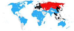
The world, September 1939
|
|
The world, December 1939
|

|
The world, May 1940
|
|
The world, December 1940
|

|
The world, March 1941
|
|
The world, April 1941
|

|
The world, July 1941
|

|
The world, December 1941
|

|
The world, June 1942
|

|
The world, November 1942
|

|
The world, December 1942
|

|
The world, July 1943
|
|
The world, December 1943
|

|
The world, June 1944
|

|
The world, August 1944
|

|
The world, December 1944
|

|
The world, May 1945
|
|
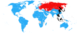
The world, August 1945
|
|
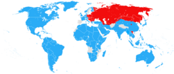
The world, September 1945
|
|
World War II in Europe (1939-1941) - Blank map
|
|
World War II in Europe (1939-1941) - French map
|
|
German and Italian control on June the 18th, 1940. (Germans and Italians are presented in blue, Non-occupied France and United Kingdom in yellow)
|
|
German and Italian control on November 14, 1940
|
|
|
Controllable map of World War II in Europe (end of august 1939 to end of december 1942)
|
|
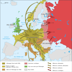
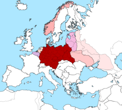
German rule of Europe, 1941-1942
|
|
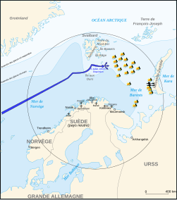
Convoy PQ-17 map, 1942-fr
|
|
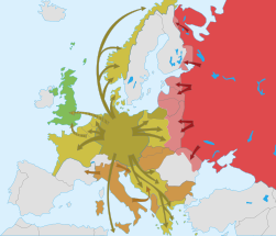
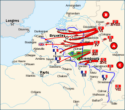
The Yellow plan: German invasion plan of Western Europe, May 1940
|

|
German invasion of Luxembourg, May 1940
|
|
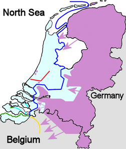
German invasion of the Netherlands in May 1940
|
|
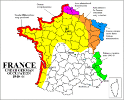
France during World War II
|

|
Extension of Germany (1935-1939) - Blank map
|

|
Extension of Germany (1935-1939) - French map
|
|
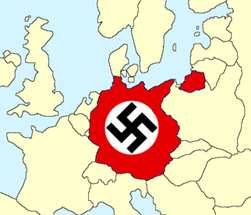
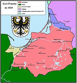
Germany at the beginning of World War II
|
|
Germany in 1939
|
|
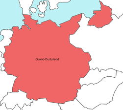
Greater Germany in 1941
|
|
Greater Germany in 1942
|
|
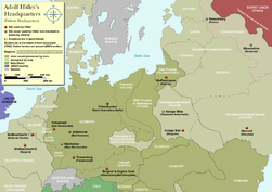
Adolf Hitler's Headquarters in Europe, 1933-1945
|

|
Allied Occupation Zones in Germany
|

|
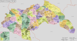
Extension of Hungary during World War II
|

|
Extension of Hungary during World War II
|

|
Extension of Hungary during World War II
|
|
Extension of Hungary during World War II
|

|
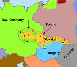
Partition of Czechoslovakia, 1938
|

|
Partition of Czechoslovakia, 1938
|
|
Partition of Czechoslovakia, 1938
|

|
Partition of Czechoslovakia, 1938-1939
|

|
Protectorate of Bohemia and Moravia
|

|
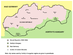
Slovakia in 1939-1945
|
|
Slovakia in 1941
|

|
Carpathian Ruthenia in 1939
|
|
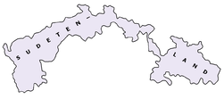
Sudetenland
|

|
The Allied offensive on Southern Central Europe
|
|
|
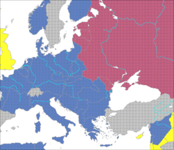
German and Soviet control on June the 18th, 1940. (Germans in blue, Soviets in violet)
|
|
The eastern front at the beginning of the German attack against USSR
|

|
Partition of Poland between Germany and Soviet Union, 1939-1941 (Border in brown)
|

|
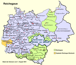
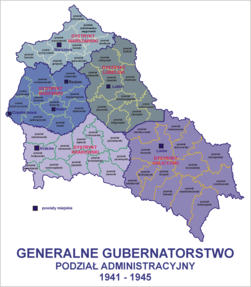
General government
|

|
General government
|
|
General government
|

|
General government
|
|
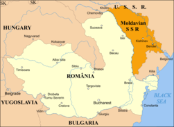
German annexions in Lithuania in 1939
|
|
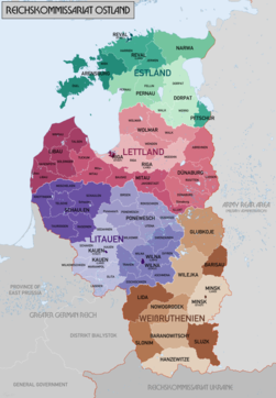
Reichskommissariat Ostland
|

|
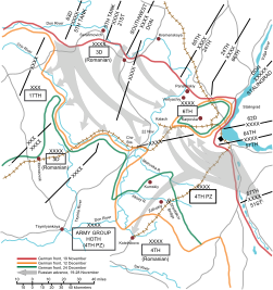
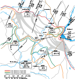
Battle of Rostov (1941)
|

|
Finland against USSR in 1941
|

|
Soviet attacks against Finland, 1943-1944
|
|
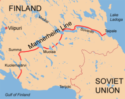
The Mannerheim line in Finland
|

|
German withdrawal from Finland, 1944 and 1945
|
|
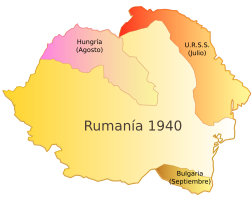
Romania in 1940
|
|
Romania before the invasion of USSR, July 2, 1941
|

|
Romania between 1941 and 1944
|

|
Romania between 1941 and 1944
|

|
Romanian rule in Transnistria (August 19, 1941 - January 21 or 19 or 29, 1944)
|
|
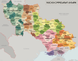
Reichskommissariat Ukraine
|
|
Battle of Stalingrad (English)
|
|
La Bataille de Stalingrad (francais)
|
Mediterranean Europe
[
edit
]

|
Balkans in 1938-1943
|
|
Balkans in 1942
|

|
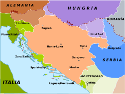
Invasion of Yugoslavia in 1941
|

|
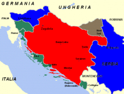
Occupation of Yugoslavia in 1941
|

|
Occupation of Yugoslavia in 1941
|

|
Occupation of Yugoslavia in 1943
|

|
Occupation of Yugoslavia in 1941
|

|
Occupation of Yugoslavia in 1942
|
|
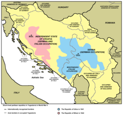
Short-lived partisan republics in Yugoslavia in World War II: the Republic of U?ice in 1941 and the Republic of Biha? in 1942
|

|
Short-lived partisan Republic of Biha? in 1942
|

|
Future Greater Yugoslavia according to project of Stevan Moljevi? (1941)
|
|
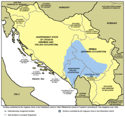
Territory controlled by the Yugoslav Army in the Fatherland (JVuO) in 1942
|

|
Areas of the Yugoslav Army in the Fatherland (JVuO) commanders, according to the truce treaties with the Germans (as of 1943)
|

|
Movement of JVuO troops in 1945
|

|
Axis genocide in Yugoslavia in WW2
|

|
Axis concentration camps in Yugoslavia in WW2
|
|
Western part of occupied Yugoslavia and Independent state of Croatia in 1941
|
|
Western part of occupied Yugoslavia and Independent state of Croatia in 1941
|
|
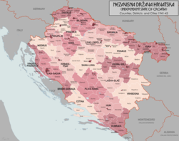
Independent State of Croatia 1941-1943
|

|
Independent State of Croatia 1941-1943
|

|
Independent State of Croatia 1943-1945
|

|
Independent State of Croatia 1943-1945
|
| [[|border|251x400px]]
|
Bosnia and Herzegovina within Independent State of Croatia in 1941-1945
|

|
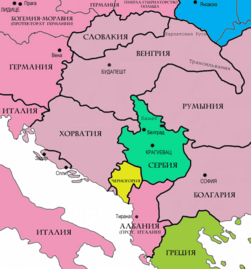
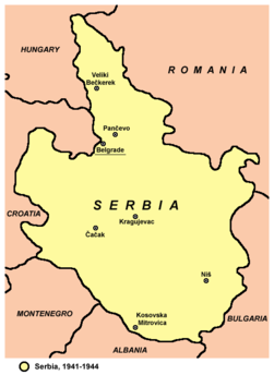
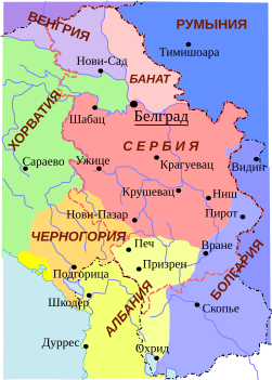
Serbia in 1941
|
|
Serbia in 1941-1944
|
|
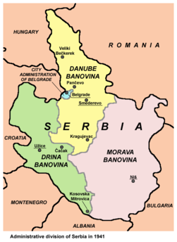
Banovinas of Serbia in 1941
|
|
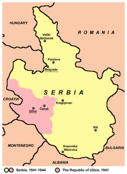
Serbia, 1941-1944
|

|
Serbia, 1941-1944
|
|
Serbia, 1941-1944
|
|
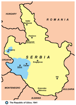
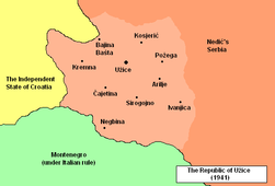
Republic of U?ice in 1941
|
|
Republic of U?ice in 1941
|
|
Republic of U?ice in 1941
|

|
Future Greater Serbia according to project of Stevan Moljevi? (1941)
|

|
"All Serbia", an enlarged Serbia proposed by Milan Nedi? in 1943
|

|
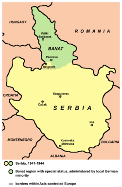
Vojvodina, 1941-1944
|

|
Hungarian occupation of Ba?ka and Baranja, 1941-1944
|

|
Map of places affected by the raid in January 1942 in southern Ba?ka
|

|
Liberated partisan territory in Syrmia in the end of 1942
|

|
Vojvodina, 1944-1945
|

|
Montenegro, 1941-1944
|

|
Montenegro, 1941-1944
|

|
Montenegro, 1941-1944
|
|
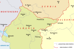
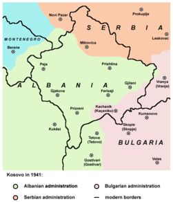
Kosovo in 1941
|
|
Kosovo in 1941
|
|
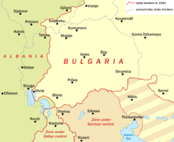
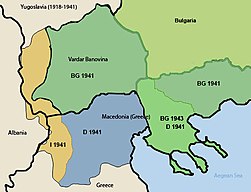
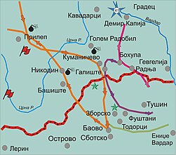
Macedonia during WWII
|
|
Macedonia during WWII
|
|
February operation of the People's liberation army of Macedonia in 1944
|

|
The Italian Governorship of Dalmatia in 1941
|

|
The Italian Province of Kotor in 1941
|

|
The Italian provinces of Ljubljana and Rijeka in 1941
|
|
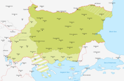
Bulgaria during WWII
|

|
Bulgaria during WWII
|
|
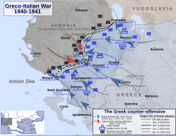
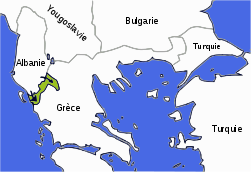
Greek counteroffensive in Albania in 1940
|

|
Greek occupation of Albania, November 1940 - March 1941
|
|
Greek occupation of Albania, November 1940 - March 1941
|

|
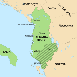
Greater Albania created by Italy, August 1941
|

|
Greater Albania created by Italy, August 1941
|
| [[|border|251x400px]]
|
Greater Albania created by Italy, August 1941
|
|
Italian offensive in Greece in 1940
|
|
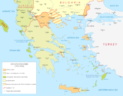
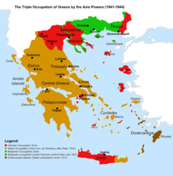
Occupation of Greece during World War II
|
|
Occupation of Greece during World War II
|

|
Occupation of Greece during World War II
|

|
The Italian colonial Empire in 1940
|
|
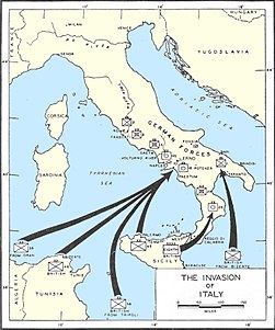
Allied invasion of Italy in 1943
|

|
German defense lines in 1943
|
|
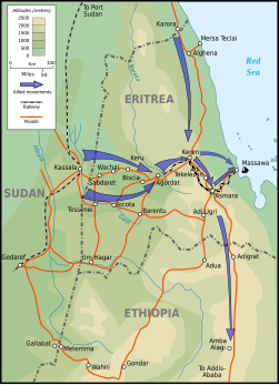
Eritrea Campain, 1941
|

|
Campagne d'Erythree, 1941
|

|
Japanese plan in 1941
|
|
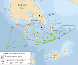
Koh Chang battle (17 january 1941)
|

|
The japanese empire in 1942
|

|
Situation in October 1944
|
Pacific operations
[
edit
]

|
Japanese attack on Pearl Harbor in 1941
|

|
Battle of the Coral Sea (may 1942)
|

|
Battle of Midway, June 1942
|
|
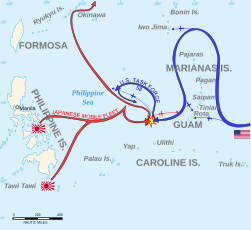
Battle of the Philippine sea, 19-20 June 1944
|

|
Bataille de la Mer des Philippines, 19-20 Juin 1944
|

|
Battle of Saipan, Summer 1944
|
|
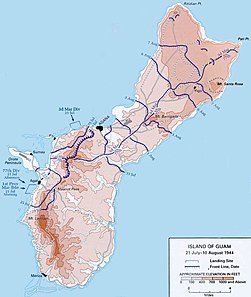
Battle of Guam, 21 July - 10 August 1944
|

|
Operation Ten-G?, April 1944 - French map
|

|
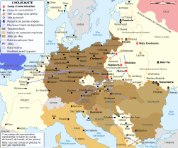
Map of the Holocaust in Europe during World War II
|

|
Map of the Holocaust in Europe during World War II
|
|
Holocaust in Europe
|

|
Holocaust in Europe
|
|
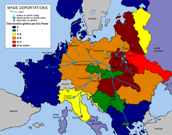
Mass deportations, ghettos, death camps
|

|
Mass deportations, ghettos, extermination camps
|
| [[|border|251x400px]]
|
Concentration camps
|

|
Main German Nazi concentration and extermination camps
|
|
|
Concentration camps in Yugoslavia
|
|
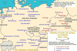
Persecution of Roma
|
|
|
Genocide in Yugoslavia
|
|
|
1942 raid in southern Ba?ka
|
Notes and references
[
edit
]
General remarks:
- The WIKIMEDIA COMMONS Atlas of the World is an organized and commented collection of geographical, political and historical maps available at Wikimedia Commons. The main page is therefore the portal to
maps
and
cartography
on Wikimedia. That page contains links to entries by country, continent and by topic as well as general
notes and references
.
- Every entry has an introduction section in English. If other languages are native and/or official in an entity, introductions in other languages are added in separate sections. The text of the introduction(s) is based on the content of the Wikipedia encyclopedia. For sources of the introduction see therefore the Wikipedia entries linked to. The same goes for the texts in the history sections.
- Historical maps are included in the continent, country and dependency entries.
- The status of various entities is disputed. See the content for the entities concerned.
- The maps of former countries that are more or less continued by a present-day country or had a territory included in only one or two countries are included in the atlas of the present-day country. For example the Ottoman Empire can be found in the
Atlas of Turkey
.
|
Entries available in the atlas
[
edit
]
- General pages
- World
- Continents and oceans
- Themes
- Historical eras
- States with wide recognition
- States with limited recognition
- Dependencies and other overseas territories
- Country subdivisions
- Belgium
- China (mainland)
- India
- Pakistan
- Spain
- United Kingdom
- United States
- Other
- Disputed subnational territories
- Other regions
- Cities
- Former sovereign states
- Former dependencies and overseas territories
- Former disputed territories
|
