The introductions of the country, dependency and region entries are in the native languages and in English. The other introductions are in English.
|
|
|
Atlas-country
|
Transnistria
|
|
|
|
|
|
|
|
Приднестровье
Придн?стров'я
Нистрения
|
|
|
|
| Русский
|
Приднестровье
- Приднестровская Молдавская Республика
[1]
Приднестровье
? часть территории Молдавии, в основном по левому берегу реки Днестр (а также город Бендеры и пригород Тирасполя на правом берегу реки), населённая (согласно переписи 2004 г.) преимущественно молдаванами (32%) и великороссами и украинцами (59%). Контролируется самопровозглашённой Приднестровской Молдавской Республикой (провозглашена 2 сентября 1990). В официальных молдавских источниках левобережная часть Приднестровья именуется Stanga Nistrului, что означает ≪Левый берег Днестра≫.
|
| Укра?нська
|
Придн?стров'я
- Придн?стровська Молдавська Республ?ка
[2]
Придн?стровська Молдавська Республ?ка
(ПМР, Придн?стров'я) - державне утворення в п?вденно-сх?дн?й ?вроп?, незалежн?сть якого проголошена, але дос? не визнана ?ншими державами. На заход? ПМР межу? з Молдовою по р?чц? Дн?стер, на сход? - з Укра?ною.
|
| Молдовеняскэ
|
Нистрения
- Република Молдовеняскэ Нистрянэ
Република Молдовеняскэ Нистрянэ
, сау РМН, есте о царэ ын естул Еуропей каре аре границэ ку Украина ла ест, ла норд, ши ла суд, ши ку Република Молдова ла вест. Нумеле вине де ла фаптул кэ есте дин естул Ниструлуй.
|
| Roman?
|
Transnistria
- Republica Moldoveneasc? Nistrean?
Transnistria
(numit? Stanga Nistrului de sursele oficiale moldovene?ti) este o regiune in Europa de est. Numele vine de la faptul c? este a?ezat? in zona Moldovei din estul raului Nistru, pe malul stang fa?? de direc?ia Nistrului. Numele de Transnistria este folosit de multe ori pentru a face referire la Republica Moldoveneasc? Nistrean?. Geografic acest lucru nu este absolut corect, Transnistria, o regiune geografic? aflat? de jure sub controlul autorit??ilor de la Chi?in?u, cuprinde ?i zone pe malul drept a Nistrului
|
| English
|
Transnistria
- Pridnestrovian Moldovan Republic
Transnistria
(also known as Pridnestrovie, officially Pridnestrovian Moldavian Republic, per the PMR constitution) is a territory within the internationally recognized boundaries of the Republic of
? Moldova
in eastern Europe, bordering to
? Ukraine
. Transnistria declared its independence as a separate republic of the U.S.S.R. on September 2, 1990. Subsequent to the collapse of the Soviet Union, the
Pridnestrovian Moldovan Republic
(PMR) has exercised de facto control over most of Transnistria. Its independence has not been recognized, and sovereignty over Transnistria continues to be an issue of contention.
|
|
|
|
| Short name
|
Transnistria
|
| Official name
|
Pridnestrovian Moldovan Republic
|
| Status
|
De-facto independent country since 1990, de jure part of
Moldova
|
| Location
|
East Europe
|
| Capital
|
Тирасполь
[3]
(Tiraspol)
|
| Population
|
475,007 inhabitants
|
| Area
|
4,163 square kilometres (1,607 sq mi)
|
| Major languages
|
Russian, Ukrainian, Romanian (Moldovan)
[4]
|
| Major religions
|
Orthodoxy
|
| More information
|
Transnistria
,
Geography of Transnistria
,
History of Transnistria
and
Politics of Transnistria
|
| More images
|
Transnistria
-
Transnistria (Category)
.
|
|
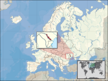
General maps

|
Map of Transnistria
|
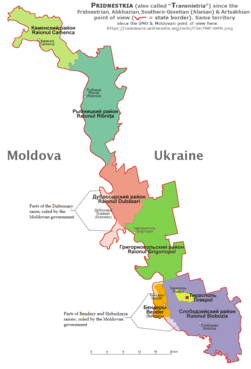
|
Map of administrative divisions of Transnistria
|

|
Moldova and Transnistria
|

|
Ethnic composition of Transnistria
|
History maps
This section holds a short summary of the history of the area of present-day Transnistria, illustrated with maps, including historical maps of former countries and empires that included present-day Transnistria.
|
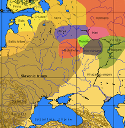
Slavic tribes in early Middle Ages
|
|
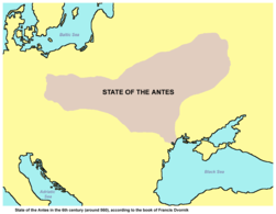
State of the Antes in the 6th century (around 560), according to the book of Francis Dvornik
|
| [[|border|251x400px]]
|
Territory of Slavic peoples (6th century).
|

|
Territory of Slavic peoples (9th century).
|
|
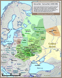
Kievan Rus 13th Century
|

|
Principalities of Kievan Rus' (1054-1132).
|

|
Russian principalities in 12th-13th centuries.
|

|
The Kingdom of Galicia?Volhynia (1245-1349)
|

|
Halych-Volhynia 12th-14th Century
|
|
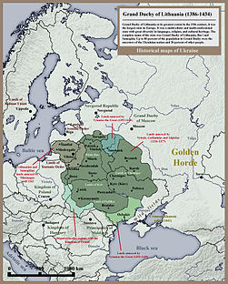
Grand Duchy of Lithuania, Rus' and Samogitia (1386-1434).
|
|
In 1386
Poland
and
Lithuania
formed a Polish-Lithuanian personal union, succeeded in 1569 by the
Polish-Lithuanian Commonwealth
. This map shows the borders in 1466 except in the south-east (which it is wrong about Principality of Moldavia where wasn't a part of the Polish kingdom but a vassal distinct state, allied with Poland).
|

|
Liberation of Belarus and most of right-bank Ukraine from the Polish-Lithuanian oppression (1772-1795).
|

|
Edisan. Liberation of Transnistria from Turks (1787-1791). Foundation of Tiraspol (1792).
|

|
European Gubernias of the Russian Empire in 1910.
|

|
Moldavian ASSR (1924-1940)
|

|
Occupied by
Romania
during the Second World War (August 19, 1941 - January 29, 1944) the
"Transnistrian region"
between Dniester,
South Bug
rivers and
Black Sea
coast. The region was divided into 13
jude?e
(counties).
|

|
Administrative map of the Moldavian SSR (1940-1991)
|
Other maps
References
- ↑
Romanization of Russian according to the
BGN/PCGN
standard:
Pridnestrov'ye - Pridnestrovskaya Moldavskaya Respublika
. Another used romanization is the
ISO 9
standard.
- ↑
Romanization of Ukrainian according to the
official Ukrainian
standard:
Prydnistrov"ya - Prydnistrovs'ka Moldavs'ka Respublika
. Another romanization is the
ISO 9
standard.
- ↑
Romanization of Russian according to the
BGN/PCGN
standard:
Tiraspol'
. Another used romanization is the
ISO 9
standard.
- ↑
Linguist generally consider Romanian and Moldovan one language.
