The introductions of the country, dependency and region entries are in the native languages and in English. The other introductions are in English.
|
|
|
Atlas-country
|
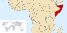
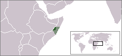
Somalia
|
|
|
|
|
|
|
|
Soomaaliya
|
|
|
|
| Soomaaliga
|
Soomaaliya
- Jamhuuriyadda Federaalka Soomaaliya
Jamhuuriyadda Federaalka Soomaaliya
waa dal ku yaalla geeska Bari ee Afrika. Waa dal raadkiisu taariikhda dunida laga heli karo, isagoo hadba magac lagu tilmaamayo, gaar ahaan xilligii Fircoonta iyo Romaankuba. Somaliya waxay u qaybsantahay 18 gobol
|
| English
|
Somalia
- Somali Republic
The
Federal Republic of Somalia
is located on the Horn of Africa in East Africa. It is bordered by
? Ethiopia
to the west,
? Djibouti
to the north-west,
? Kenya
on its south-west, and the Gulf of Aden on its north, and the Indian Ocean at its east. The Somali state currently exists solely in a de jure capacity; Somalia has a recognized central government authority.
? Somaliland
withdrew from its political union with Somalia. See also
Somali Civil War maps
|
| Other languages
|
Arabic:
??????? (??????????: Soomaaliya?)? ????? ????? ???? ??????? ??????? (??????????: Jamhuuriyadda Soomaaliya?) ????? ???? ???? ??? ???? ??????? ??????? ????????????? ?? ???? ??? ?? ????? ????? ???????? ?? ??? ???????. ??? ??????? ?? ????? ????? ????????. ?????? ?? ?????? ?????? ??????? ?????? ?? ?????? ??????? ????? ??? ?? ?????? ??????? ?????? ?? ????? ???????? ?? ?????. ????? ???? ???? ????? ?? ???? ???????. ???? ???????? ??????? ??? ?????? ??????? ??????????. ?????? ?????? ??? ??? ???? ????? ?? ??? ?????? ???????? ???????? ??? ????????.
|
|
|
|
| Short name
|
Somalia
|
| Official name
|
Somali Republic
|
| Status
|
Independent country since 1960
|
| Location
|
East Africa
|
| Capital
|
Muqdisho (Mogadishu)
|
| Population
|
12,316,895 inhabitants
|
| Area
|
647,657 square kilometres (250,062 sq mi)
|
| Major languages
|
Somali, Arabic (both official)
|
| Major religions
|
Islam
|
| More information
|
Somalia
,
Geography of Somalia
,
History of Somalia
and
Politics of Somalia
|
| More images
|
Somalia
-
Somalia (Category)
.
|
|
General maps

|
Map of Somalia
|

|
Map of Somalia
|
History maps
This section holds a short summary of the history of the area of present-day Somalia, illustrated with maps, including historical maps of former countries and empires that included present-day Somalia.

|
Colonial partition of the Horn of Africa around 1900
|

|
Somalia in the Italian colonial empire in 1940
|

|
Governorate of Somalia Italians
|
|
Italian Somaliland
|

|
Battle of Mogadishu 1993
|

|
Regions of Somalia
Map of Somalia showing the major self-declared states and areas of factional control, as of December 2006.
- Pink -
Somaliland
(declared independent, unrecognized)
- Blue -
Puntland
(declared autonomous)
- Gold-brown - controlled directly by
Supreme Islamic Courts Council
(includes Mogadishu)
- Light Yellow - allied to the Supreme Islamic Courts Council
- Orange - controlled by Transitional National Government (TNG)
- White dot -
Baidoa
(seat of the Transitional National Government)
- Green line - former eastern boundary of Southwestern Somalia
- Light Green -
Southwestern Somalia
(declared regional autonomy; associated with the TNG)
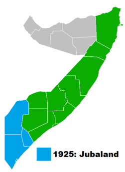
- Light Purple -
Jubaland
(also formerly 9 & 10; declared regional Autonomy and associated with the TNG)
- Grey - No government
|

|
Political Situation in Somalia at the height of the Islamic Courts Union expansion
|

|
Current political situation in Somalia
|
|
self-declared state of Galmudug
|

|
Somalia administrative divisions, regions and districts
|

|
Somalia regions (numbered)
|

|
Somalia districts
|
Other maps

|
Population density map, 2002
|

|
Ethnic groups, 2002
|

|
Ethnic groups, 1977
|

|
Topography
|

|
Minerals
|
Satellite maps

|
Satellite map
|
Notes and references
General remarks:
- The WIKIMEDIA COMMONS Atlas of the World is an organized and commented collection of geographical, political and historical maps available at Wikimedia Commons. The main page is therefore the portal to
maps
and
cartography
on Wikimedia. That page contains links to entries by country, continent and by topic as well as general
notes and references
.
- Every entry has an introduction section in English. If other languages are native and/or official in an entity, introductions in other languages are added in separate sections. The text of the introduction(s) is based on the content of the Wikipedia encyclopedia. For sources of the introduction see therefore the Wikipedia entries linked to. The same goes for the texts in the history sections.
- Historical maps are included in the continent, country and dependency entries.
- The status of various entities is disputed. See the content for the entities concerned.
- The maps of former countries that are more or less continued by a present-day country or had a territory included in only one or two countries are included in the atlas of the present-day country. For example the Ottoman Empire can be found in the
Atlas of Turkey
.
|
Entries available in the atlas
- General pages
- World
- Continents and oceans
- Themes
- Historical eras
- States with wide recognition
- States with limited recognition
- Dependencies and other overseas territories
- Country subdivisions
- Belgium
- China (mainland)
- India
- Pakistan
- Spain
- United Kingdom
- United States
- Other
- Disputed subnational territories
- Other regions
- Cities
- Former sovereign states
- Former dependencies and overseas territories
- Former disputed territories
|
